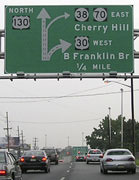
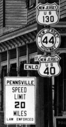
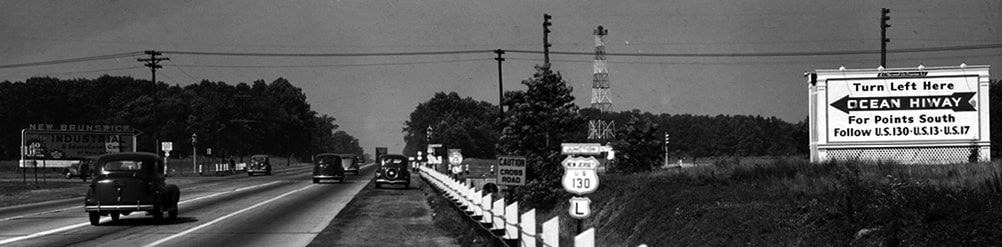
^ photo c. 1942 at what is now the north terminus of US 130 (source)
End of US highway 130 |
 |
|
1926-1934
1934-1938
|
|
1958-present
Summa
|
|
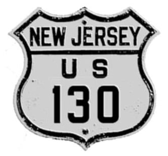
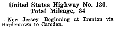
Mileage: in 1989 AASHTO listed a figure of 83 miles for US 130. That closely matches our own 2020 measurement, which yielded 83.2 miles. US 130 was an original 1926 route; this excerpt is from AASHO's Apr. 1927 route log:
|
|
|
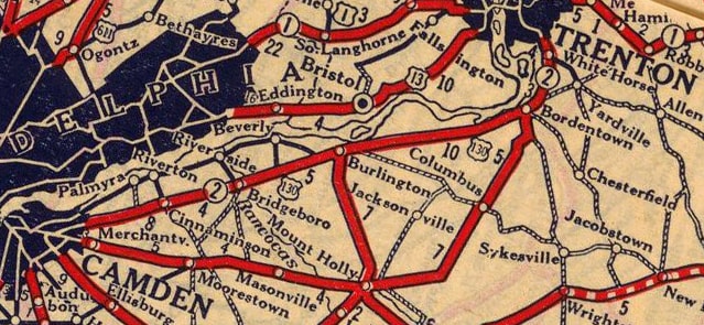
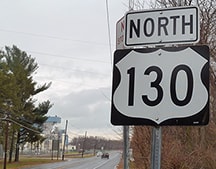
US 130 had to be given an east/west number, because originally US 30 was the only other US route with which it connected. Despite that, it has probably always been signed as a north/south route. Therefore it may have been more appropriate to number it as US x13: even though it did not connect with US 13, it did run along the opposite bank of the Delaware River, parallel to US 13, and it formed something of an alternate route between Trenton and the Philadelphia area:
|
c. 1927, Rand McNally
|
|
The junction where it ended in Trenton was probably at the current US 206 / NJ 31 intersection. US 1 used Princeton Street to the north of that intersection, and Warren Street to the south. US 130 would have begun by heading down Broad Street. This photo was looking south on Princeton:
|

Nelson, Sep. 2007
|
That was southbound US 1, which continued ahead on Warren. US 130 begin to the left on Pennington, and then turned south on Broad.
|
The south end of US 130 was originally in downtown Camden, probably at the Ben Franklin Bridge plaza. US 130 came in on Linden Street, ending at Broadway, which carried US 30 up to the bridge. That intersection no longer exists, because of I-676 and its access ramps.
|
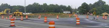
But later in 1927, the US 130 bypass around Camden was built. However, the current alignment of US 30 did not happen until about 1929, so in between US 130 would have ended at Collingswood Circle, which is now the south/east split of US 30 and US 130. Unfortunately, that area was under construction at the time of this photo:
|
Elbert, July 2006
|
|
When US 30 was rerouted in Camden, US 130 was truncated to Airport Circle. This photo was looking north on westbound US 30 / northbound US 130:
|
Elbert, July 2006
|
The two routes split there: US 30 loops around to the right and continues left past downtown Camden and across the river into Philadelphia. Straight ahead was once the south beginning of US 130.
|
|
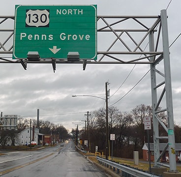
In 1934, US 130 was extended south from Camden to Pennsville. By then US 40 was already using the Pennsville-New Castle ferry to cross the Delaware River (instead of its original routing, which used the Penns Grove-Wilmington ferry), and that would remain the case until the Delaware Memorial Bridge was built:
|
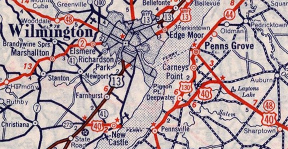
c. 1939, Rand McNally
|
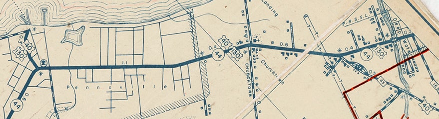
However, when US 130 was extended, it did not end at its junction with US 40 near Deepwater; instead the routes overlapped down to the ferry landing:
|
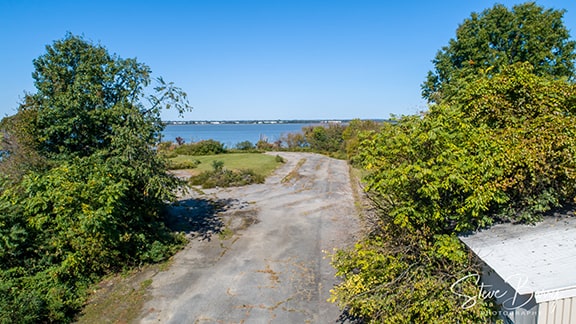
This image was looking west on Ferry Road in Pennsville. US 130 ended at this crossroad (Enlow Place). Visible ahead is the old concrete driveway to the ferry landing:
|
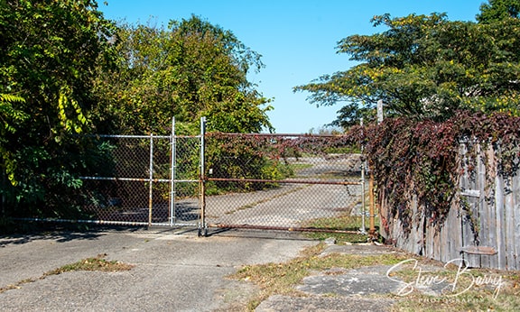
Barry, Jan. 2022
|
The old access road is no longer open to the public, but this photographer used a drone to capture the historic roadway that US 40 traffic used to get to the ferry landing:
Barry, Jan. 2022
|
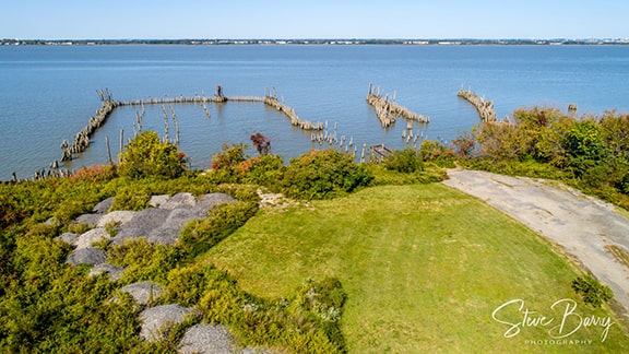
Barry, Jan. 2022
|
|
Drivers exiting the ferry there and heading the opposite direction (eastbound US 40 / northbound US 130) went north on what is now NJ hwy. 49 (but was historically NJ 44):
|
c. 1939 (linked to source)
|
|
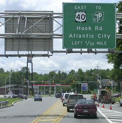
The two routes diverged right about where I-295 is now, with US 40 following the now-separated segments of Old Pennsville-Auburn Road. This scene was approaching that area from the south via NJ 49 (Broadway), but historically this was US 40-130, and eastbound US 40 continued by making a slight curve to the right via Old Pennsville-Auburn Rd (signposted here as Hook Road):
|
Karners, Dec. 2016
|
At Danceys Corner US 40 joined the pre-1929 alignment (now NJ 48). Today's Bridge opened in 1951, and US 40 traffic was directed to use it (instead of the Pennsville-New Castle ferry). So then the south end of US 130 was truncated to its current terminus. In the photo above, historic US 130 (NJ 49) continued by making a slight curve to the left, to what is now the south beginning of US 130:

Karners, Dec. 2016
|
The most distant of those green signs is shown close-up below:
Karners, Dec. 2016
|
|
One half-mile further north is the first northbound confirming marker...
|
Karners, Dec. 2016
|
...and directly across Broadway from that assembly is the last southbound trailblazer:
|
Karners, Dec. 2016
|
|
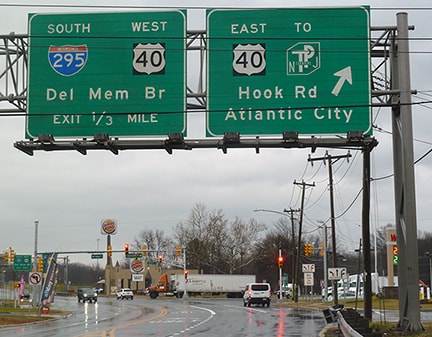
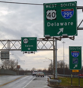
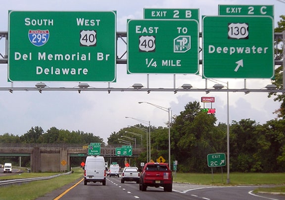
Continuing a half-mile in that direction (south), drivers reach the array of sign bridges at I-295 interchange, where the US 130 designation ends:
Karners, Dec. 2016
|
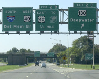
Straight ahead is now designated NJ 49, but historically the US 130 designation continued further ahead, where it joined with US 40:
Elbert, July 2006
To the left is now a connection to eastbound US 40, to the NJ Turnpike, and to Hook Rd. But before the Bridge was built, US 130 and US 40 joined at the traffic signal in the background.
|
|
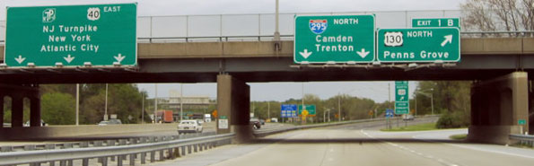
The following photos show the beginning of US 130 from the perspective of I-295; these first two were taken while heading west on southbound I-295...
Buchanan/Nitzman, Oct. 2004
|
Morrison, Aug. 2021
|
|
...and here is a shot from the opposite direction; US 130 traffic goes under the bridge, exits right, loops around, and heads to the left on the overpass:
|
Nitzman, Apr. 2004
|
|
Also in 1934 the US 130 designation was extended north from Trenton to its junction with US 1 in North Brunswick Township (the same location as US 130's current terminus, as we will see later). That arrangement was illustrated on this 1939 NJDoT map, which showed Georges Road north of US 1 and Milltown Circle designated only as Rte. 25M (not US 130):
|
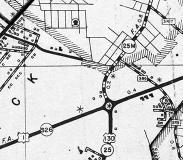
c. 1939 (used as a base for a 1950 Census Enumeration District Map)
|
This 1939 photo was taken looking south on US 1, approaching Milltown Circle. Below the US 130 marker is a smaller shield with an "L". That indicated that US 130 began to the left (south), but did not extend to the right (north on Georges Rd):
c. 1939 (linked to source)
The following photo was taken in the same year, looking the opposite direction (northbound on US 1). It does not provide any clues about whether or not US 130 terminated at the upcoming intersection, but it does provide an excellent view of the historic route markers:
c. 1939 (linked to source)
In 1938 the US 130 designation was extended a few miles, such that it ended at its junction with NJ 27 in downtown New Brunswick (although at the time of the map and photos above, that change had not yet been implemented). The 1948 photo below clearly shows that US 130 was signed north from Milltown Circle (which no longer exists, but it was located right where the north terminus of US 130 is now, at the interchange with US 1):
c. 1948 (linked to source)
|
USGS topo maps from 1942 and 1954 also showed that US 130 ended in the downtown area:
|
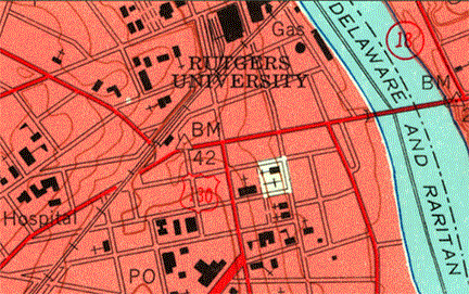
c. 1954 (USGS)
|
|
At that time US 130 ended on George Street at Albany Street, where NJ 171 now ends at NJ 27. Here are some photos from that intersection:
|
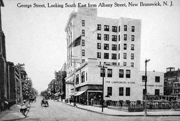
Rutgers University Libraries Special Collections and Archives
|
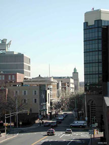
Siegel, 2002
|
The crossroad is Albany Street, which carried US 1. Straight ahead on George was the north beginning of US 130. The building shown in the historic photo still exists, but now a modern building stands just to the north, blocking it from view in the second photo. In 1958 New Jersey had US 130 truncated back to its former endpoint in North Brunswick Twp, so US 130 signage north of US 1 was removed:
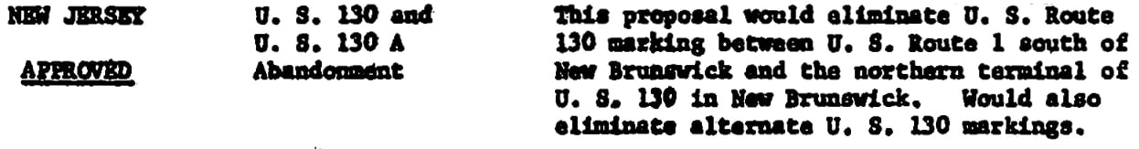
|
Thus US 130's current terminus was re-established, with Georges Rd continuing into downtown being re-designated as NJ 171. In 2003 that junction was reworked into a grade-separated interchange. This photo was taken heading north on US 130 towards its terminus, showing the sign bridge where it splits:
|
Buchanan/Nitzman, Oct. 2004
|
|
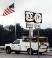
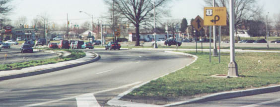
If a driver takes the right fork, they will soon be at the intersection shown in these photos, which is the actual end of the route, as noted on the signpost in the median:
|
Nasiatka, Sept. 2003
|
Nasiatka, Sept. 2003
|
|
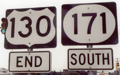
Where US 130 ends, NJ 171 begins (although that should have been a "North" tab, not "South", and it has since been changed). On the reverse of that assembly is the first southbound US 130 sign:
|
Nasiatka, Sept. 2003
|
|
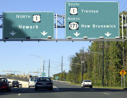
Next is a shot of the north beginning of US 130 as seen from southbound US 1:
|
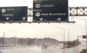
Nasiatka, Sept. 2003
|
|
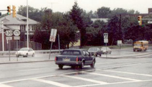
These next photos were taken before today's interchange was built. This one was taken from Georges Road, looking north at the junction with US 1:
|
Nitzman, 2000
|
|
There was some space on the post above that US 130 shield; it is likely that an "End" sign was formerly mounted there. The intersection in the distance was the actual terminus of the route; this photo shows that same junction from a closer vantage point:
|
Nitzman, 2000
|
Research and/or photo credits: Carter Buchanan; Chris Elbert; Karin and Martin Karner; Dan Moraseski; Jeff Morrison; J.P. Nasiatka; Steven Nelson; Alex Nitzman; Mike Roberson; Dale Sanderson; Mike Siegel; Michael Summa
Page originally created 2000;
last updated Jan. 4, 2024.
last updated Jan. 4, 2024.
