US Ends .com
  • Home
  • Store
    • US highway map
    • Florida US highway map
  • Endpoints
    • US 1 - US 9 >
      • 1 >
        • 201
        • 301
        • 401 [i]
        • 401 [ii]
        • 401
        • 501
        • 601
        • 701
      • 2w >
        • 102
      • 2e >
        • 202
        • 302
      • 3
      • 4 >
        • 104
      • 5
      • 6 >
        • 106
        • 206
      • 7
      • 8
      • 9 >
        • 109*
        • 209
        • 309
    • US 10 - US 19 >
      • 10 >
        • 110
        • 210
        • 310
        • 410
      • 11 >
        • 111
        • 211
        • 311
        • 411 [i]
        • 411 [ii]
        • 411
        • 511*
        • 611
        • 711*
      • 12 >
        • 112
        • 212
        • 312
      • 13 >
        • 113
        • 213
      • 14
      • 15
      • 16 >
        • 116
        • 216
      • 17 >
        • 17-1
        • 117 [i]
        • 117
        • 217
      • 18 >
        • 118
        • 218
      • 19 >
        • 119
        • 219
        • 319
    • US 20 - US 29 >
      • 20 >
        • 120
        • 220
        • 320
        • 420
      • 21 >
        • 121 [i]
        • 121
        • 221
        • 321
        • 421
        • 521
      • 22 >
        • 122 [i]
        • 122 [ii]
        • 222
        • 322
        • 422e
        • 422w
        • 522
        • 622*
      • 23 >
        • 123 [i]
        • 123
        • 223
      • 24 >
        • 124
        • 224
      • 25
      • 26 >
        • 126
      • 27 >
        • 127
        • 227
      • 28
      • 29 >
        • 129
    • US 30 - US 39 >
      • 30 >
        • 130
        • 230
        • 330
        • 430
        • 530
        • 630*
        • 730
        • 830
      • 31 >
        • 131
        • 231
        • 331 [i]
        • 331
        • 431
      • 32
      • 33
      • 34
      • 35
      • 36 >
        • 136
      • 38 >
        • 138
    • US 40 - US 49 >
      • 40 >
        • 140
        • 240
        • 340
      • 41 >
        • 141
        • 241 [i]
        • 241 [ii]
        • 341
        • 441
        • 541
        • 641
      • 42
      • 43
      • 44
      • 45
      • 46
      • 48 [i]
      • 48 [ii]
      • 48
      • 49
    • US 50 - US 59 >
      • 50 >
        • 150
        • 250
        • 350
        • 450
        • 550
        • 650
      • 51 - 55 >
        • 51 >
          • 151
        • 52 >
          • 152
        • 53
        • 54 >
          • 154
        • 55
      • 56 >
        • 156
      • 57
      • 58 >
        • 158
        • 258
      • 59 >
        • 159
        • 259
    • US 60 - US 69 >
      • 60 >
        • 160
        • 260
        • 360
        • 460
      • 61 - 65 >
        • 61 >
          • 161
        • 62
        • 63 >
          • 163 [i]
        • 64 >
          • 164 [i]
          • 164 [ii]
          • 264
        • 65 >
          • 165
      • 66 >
        • 166
        • 266
        • 366 [i]
        • 366 [ii]
        • 466
        • 566
        • 666
      • 67 >
        • 167
      • 68 >
        • 168
      • 69 >
        • 169
    • US 70 - US 79 >
      • 70 >
        • 170
        • 270 [i]*
        • 270
        • 370
        • 470
      • 71 >
        • 171
        • 271
        • 371 [i]
        • 371
      • 72 - 76 >
        • 72
        • 73
        • 74
        • 75 >
          • 175
          • 275
        • 76 >
          • 176
          • 276
      • 77 >
        • 177
        • 277
        • 377
      • 78 >
        • 178
        • 278
        • 378
      • 79
    • US 80 - US 89 >
      • 80 - 84 >
        • 80 >
          • 180 [i]
          • 180
          • 280
          • 380
        • 81 >
          • 181
          • 281
        • 82
        • 83 >
          • 183
          • 283
          • 383
        • 84
      • 85 - 89 >
        • 85 >
          • 185
          • 285 [i]
          • 285
          • 385 [i]
          • 385
          • 485
        • 87 >
          • 187
          • 287
        • 89 >
          • 189 [i]
          • 189
    • US 90 - US 99 >
      • 90 - 94 >
        • 90 >
          • 190
          • 290
        • 91 >
          • 191
          • 491
        • 92 >
          • 192
        • 93
        • 94
      • 95 -98 >
        • 95 >
          • 195
          • 295
          • 395
        • 96 [i]
        • 96
        • 97 >
          • 197
        • 98
      • 99 >
        • 199
        • 299
        • 399
    • Anomalies >
      • 101
      • 163
      • 400
      • 412
      • 425
  • Places
    • A-L >
      • A >
        • Aberdeen
        • Albuquerque
        • Amarillo
        • Apalachicola
        • Astoria
        • Atlantic
      • B >
        • Baltimore
        • Baton Rouge
        • Bay Area
        • Bishop
        • Boone
        • Brady
        • Bristol
        • Brownsville
        • Brunswick
      • C >
        • Charleston
        • Chattanooga
        • Chicago
        • Cincinnati
        • Cleveland
        • Cody
        • Corpus
        • Cortez
        • Council Bluffs
        • Covington
        • Crescent
        • Cumberland Gap
      • D-E >
        • Dallas
        • Des Moines
        • Detroit
        • Dothan
        • Douglas
        • El Paso
        • Eugene
        • Erie
      • F >
        • Farmington
        • Flagstaff
        • Florence
        • Fox Valley
        • Franklin
      • G >
        • Gallup
        • Grand Junction
        • Grand Portage
        • Grayling
        • Great Falls
        • Greeley
      • H-I >
        • Hardeeville
        • Harrisburg
        • Holbrook
        • Idaho Falls
        • Int'l Falls
      • J-K >
        • Jacksonville
        • Joplin
        • Junction
        • Kansas City
        • Keokuk
        • Key West
        • Kingman
      • L >
        • Laredo
        • Lewiston
        • Long Beach
        • Los Angeles
        • Louisville
        • Lubbock
    • M-R >
      • M >
        • Mackinaw
        • Madison
        • Maryhill
        • Maysville
        • Miami
        • Midway
        • Miles City
        • Milford
        • Milwaukee
        • Minneapolis
        • Mobile 31
        • Mobile 31-43-45
        • Montgomery
        • Monticello
        • Mount Vernon
      • N-O >
        • Nags Head
        • Naples
        • Natchez
        • New Castle
        • New Orleans
        • Niagara
        • Norlina
        • Ocean City
        • Oklahoma City
      • P >
        • Pee Dee
        • Pembina
        • Pensacola
        • Petersburg
        • Philadelphia
        • Piegan
        • Pineville
        • Port Arthur
        • Portsmouth
      • Q-R >
        • Quad Cities
        • Rapid City
        • Raton
        • Reading
        • Richmond
        • Rockingham
        • Rouses Point
    • S-Z >
      • S >
        • San Antonio
        • San Antonio NM
        • San Diego
        • Santa Fe
        • Savannah
        • Sioux
        • Springer
        • Springfield
        • St. Ignace
        • St. John
        • St. Paul
        • St. Pete
      • T-U-V >
        • Tallahassee
        • Tampa
        • Toledo
        • Trinidad
        • Ucolo
        • VA Beach
      • W >
        • Walterboro
        • Waverly
        • West Memphis
        • Wilmington
        • Wilson
        • Wrightsville
      • Y >
        • Yellowstone E
        • Yellowstone N
        • Yellowstone NE
        • Yellowstone S
        • Yellowstone W
  • Highways
    • Map of all endpoints
    • Sources
    • History
    • 1926 almost-routes
    • Intra-state routes
    • Numbering
    • Colors
    • Blog
  • Bonus
    • Colorado >
      • Lowest point
      • Antipodes
      • Toponymy >
        • Roots
      • Colloquialisms
      • Populations
      • Denvers
    • Washington Meridian
    • Watersheds >
      • Headwaters Hill
      • Three Waters Mtn.
      • Parting of the Waters
    • Geo-centers >
      • 48 states
      • 50 states
      • North America
    • State corners >
      • AZ-CO-NM-UT
      • CO-UT-WY
      • CO-NE-WY
      • CO northeast
      • CO-KS-NE
      • CO-KS-OK
      • CO-NM-OK
      • NM-OK-TX
      • NM southeast
      • TX northwest
    • ooss.space
  • Connect
    • Author/history
    • Rationale
    • Contact
    • Contributors
    • Submissions

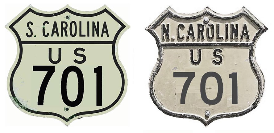
End of US highway 701

View a map showing this route.
Get your very own map showing all current and historic US routes!
Picture
Summa
1932-1992
  • North: Four Oaks, NC
  • South: Charleston, SC
1992-present
  • North: Four Oaks, NC
  • South: Georgetown, SC

Mileage: in 1989 AASHTO listed a figure of 247 miles for US 701... however, that included the mileage of US 701's associated business routes.  According to the state subtotals on AASHTO's 1989 spreadsheet, mainline US 701's actual end-to-end total at the time was 231 miles... but at the time the route still ended in Charleston.  US 701 has since been truncated to Georgetown, and our own 2020 measurement yielded 172.6 miles.

US 701 was commissioned in 1932; its north end has always been at the edge of Four Oaks:
Picture
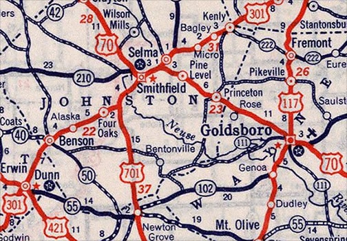
c. 1939, Rand McNally
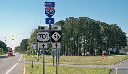
US 701 has never connected with its implied "parent" route (US 1), but here at Four Oaks it connects with its "sibling", US 301.  These photos show the end of US 701; straight ahead becomes northbound US 301, while southbound US 301 is to the left:
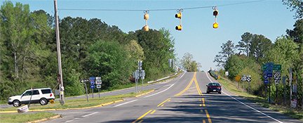
Picture
Karners, Apr. 2014
Picture
Karners, Apr. 2014
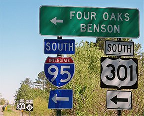
The I-95 overpass is just behind the camera, but access to the southbound on-ramp is to the left on US 301.  This shot was looking north on US 301; that designation continues along the road in the distance curving to the left, while off to the right is the north beginning of US 701, and access to northbound I-95:
Picture
Karners, Apr. 2014 (essentially unchanged since at least 2000)
This perspective is from southbound US 301, which continues by curving to the right, while straight ahead becomes the north beginning of US 701 (the red truck at far left is at the north end of that route):
Picture
Karners, Apr. 2014

Originally US 701 extended southward into Charleston; it was the first US route to serve the coast between there and Wilmington NC (originally US 17 went through Florence SC to get between those two cities).  Although the US 701 designation was not officially truncated to Georgetown until 1992, it was not given much respect during its latter years in the area; here is an eyewitness recollection:

"In the late 1980s, US 701 was only signed as such on the Pearman Bridge over the Cooper River in Charleston.  This bridge also carried US 17 across the river.  [This gave the impression that] US 701 ended at the North (East) end of the bridge, and never actually entered Charleston proper.  In any case, I don't remember any guide signs for US 701 from US 52, US 78, or even I-26.  US 701 was poorly-signed between Georgetown and Charleston."
Signage at the current terminus in Georgetown is painfully dismal too; this photo was looking south on Fraser Street:
Picture
Karners, Apr. 2014
The north beginning of US 17 Alt. is to the right on Exchange Street.  But there was no mention of the fact that straight ahead on Fraser is southbound US 17, nor that northbound US 17 should turn left on Church Street.  The south terminus of US 521 is one block ahead (or travelers could take a shortcut by turning right, but there was no mention of that route, either).  The 1992 AASHTO minutes specify that US 701 was truncated to the junction with US 521, but signage in the field has always indicated that US 701 ends at the junction with US 17.
In the background is a side-view of a large sign assembly: we will see a face-on view of that below, but first, these next photos were taken heading the opposite direction (north on Fraser, or northbound US 17):
Picture
Cozart/Nitzman, Nov. 2006 (slightly different as of 2014)
Picture
Cozart/Nitzman, Nov. 2006 (essentially the same as of 2014)
US 17 traffic curves right on Church, while straight ahead on Fraser is the south beginning of US 701.  This photo shows signage for traffic heading east on Exchange: 
Picture
Cozart/Nitzman, Nov. 2006 (essentially unchanged as of 2014)
That is the north end of US 17A, and the south beginning of US 701 is to the left on Fraser.  These next photos were from southbound US 17, which at this point is actually heading northwest on Church:
Picture
Prince, 2000
Picture
Cozart/Nitzman, Nov. 2006
It is interesting that the "Alt US 17" sign was replaced, but its neighbor was not replaced at the same time... and that one actually should have been replaced: while it is true that US 701 historically turned left here and extended southwest out of Georgetown, that has not been the case since 1992.  (And as of 2019, there was no longer any reference to US 701 there.)  Today the south beginning of US 701 is to the right... yet that is not mentioned at all.  However, signage at the actual intersection is better:
Picture
Cozart/Nitzman, Nov. 2006 (unchanged as of 2014)
(That is the same assembly visible in the first Georgetown photo above.)  US 17 continues left on Fraser, while US 701 begins right on Fraser.  Straight ahead on Exchange is the north beginning of US 17A.  In about a block, Exchange meets Highmarket Street and US 521, the terminus for which is just one block to the left on Fraser.

Research and/or photo credits: Justin Cozart; Stuart Davis; Karin and Martin Karner; Jeff Morrison; Alex Nitzman; Adam Prince; Mike Roberson; Dale Sanderson; Michael Summa; Morgan Younce
Page originally created 2000;
last updated Nov. 28, 2021.
Copyright © 1998-2023
Picture