US Ends .com
  • Home
  • Store
    • US highway book
    • US highway map
    • Florida US highway map
  • Endpoints
    • US 1 - US 9 >
      • 1 >
        • 201
        • 301
        • 401 [i]
        • 401 [ii]
        • 401
        • 501
        • 601
        • 701
      • 2w >
        • 102
      • 2e >
        • 202
        • 302
      • 3
      • 4 >
        • 104
      • 5
      • 6 >
        • 106
        • 206
      • 7
      • 8
      • 9 >
        • 109*
        • 209
        • 309
    • US 10 - US 19 >
      • 10 >
        • 110
        • 210
        • 310
        • 410
      • 11 >
        • 111
        • 211
        • 311
        • 411 [i]
        • 411 [ii]
        • 411
        • 511*
        • 611
        • 711*
      • 12 >
        • 112
        • 212
        • 312
      • 13 >
        • 113
        • 213
      • 14
      • 15
      • 16 >
        • 116
        • 216
      • 17 >
        • 17-1
        • 117 [i]
        • 117
        • 217
      • 18 >
        • 118
        • 218
      • 19 >
        • 119
        • 219
        • 319
    • US 20 - US 29 >
      • 20e >
        • 120
        • 220
        • 320
        • 420
      • 20w
      • 21 >
        • 121 [i]
        • 121
        • 221
        • 321
        • 421
        • 521
      • 22 >
        • 122 [i]
        • 122 [ii]
        • 222
        • 322
        • 422e
        • 422w
        • 522
        • 622*
      • 23 >
        • 123 [i]
        • 123
        • 223
      • 24 >
        • 124
        • 224
      • 25
      • 26 >
        • 126
      • 27 >
        • 127
        • 227
      • 28
      • 29 >
        • 129
    • US 30 - US 39 >
      • 30 >
        • 130
        • 230
        • 330
        • 430
        • 530
        • 630*
        • 730
        • 830
      • 31 >
        • 131
        • 231
        • 331 [i]
        • 331
        • 431
      • 32
      • 33
      • 34
      • 35
      • 36 >
        • 136
      • 38 >
        • 138
    • US 40 - US 49 >
      • 40 >
        • 140
        • 240
        • 340
      • 41 >
        • 141
        • 241 [i]
        • 241 [ii]
        • 341
        • 441 >
          • 441n
          • 441s
        • 541
        • 641
      • 42
      • 43
      • 44
      • 45
      • 46
      • 48 [i]
      • 48 [ii]
      • 48
      • 49
    • US 50 - US 59 >
      • 50 >
        • 150
        • 250
        • 350
        • 450
        • 550
        • 650
      • 51 - 55 >
        • 51 >
          • 151
        • 52 >
          • 152
        • 53
        • 54 >
          • 154
        • 55
      • 56 >
        • 156
      • 57
      • 58 >
        • 158
        • 258
      • 59 >
        • 159
        • 259
    • US 60 - US 69 >
      • 60 >
        • 160
        • 260
        • 360
        • 460
      • 61 - 65 >
        • 61 >
          • 161
        • 62
        • 63 >
          • 163 [i]
        • 64 >
          • 164 [i]
          • 164 [ii]
          • 264
        • 65 >
          • 165
      • 66 >
        • 166
        • 266
        • 366 [i]
        • 366 [ii]
        • 466 [i]*
        • 466 [ii]
        • 566
        • 666
      • 67 >
        • 167
      • 68 >
        • 168
      • 69 >
        • 169
    • US 70 - US 79 >
      • 70 >
        • 170
        • 270 [i]*
        • 270
        • 370
        • 470
      • 71 >
        • 171
        • 271
        • 371 [i]
        • 371 [ii]
        • 371
      • 72 - 76 >
        • 72
        • 73
        • 74
        • 75 >
          • 175
          • 275
        • 76 >
          • 176
          • 276
      • 77 >
        • 177
        • 277
        • 377
      • 78 >
        • 178
        • 278
        • 378
      • 79
    • US 80 - US 89 >
      • 80 - 84 >
        • 80 >
          • 180 [i]
          • 180
          • 280
          • 380
        • 81 >
          • 181
          • 281
        • 82
        • 83 >
          • 183
          • 283
          • 383
        • 84
      • 85 - 89 >
        • 85 >
          • 185
          • 285 [i]
          • 285
          • 385 [i]
          • 385
          • 485
        • 87 >
          • 187
          • 287n
          • 287s
        • 89n
        • 89s >
          • 189 [i]
          • 189
    • US 90 - US 99 >
      • 90 - 94 >
        • 90 >
          • 190
          • 290
        • 91 >
          • 191 >
            • 191n
            • 191s
          • 491
        • 92 >
          • 192
        • 93
        • 94
      • 95 -98 >
        • 95 >
          • 195
          • 295
          • 395
        • 96 [i]
        • 96
        • 97 >
          • 197
        • 98
      • 99 >
        • 199
        • 299
        • 399
    • Anomalies >
      • 101
      • 163
      • 400
      • 412
      • 425
  • Places
    • A-L >
      • A >
        • Aberdeen
        • Albuquerque
        • Amarillo
        • Apalachicola
        • Astoria
        • Atlantic
      • B >
        • Baltimore
        • Baton Rouge
        • Bay Area
        • Bishop
        • Boone
        • Brady
        • Bristol
        • Brownsville
        • Brunswick
      • C >
        • Charleston
        • Chattanooga
        • Chicago
        • Cincinnati
        • Cleveland
        • Cody
        • Corpus
        • Cortez
        • Council Bluffs
        • Covington
        • Crescent
        • Cumberland Gap
      • D-E >
        • Dallas
        • Des Moines
        • Detroit
        • Dothan
        • Douglas
        • El Paso
        • Erie
        • Eugene
      • F >
        • Farmington
        • Flagstaff
        • Florence
        • Fox Valley
        • Franklin
      • G >
        • Gallup
        • Georgetown
        • Grand Junction
        • Grand Portage
        • Grayling
        • Great Falls
        • Greeley
      • H-I >
        • Hardeeville
        • Harrisburg
        • Holbrook
        • Idaho Falls
        • Int'l Falls
      • J-K >
        • Jacksonville
        • Joplin
        • Junction
        • Kansas City
        • Keokuk
        • Key West
        • Kingman
      • L >
        • Laredo
        • Lewiston
        • Long Beach
        • Los Angeles
        • Louisville
        • Lubbock
    • M-R >
      • M >
        • Mackinaw
        • Madison
        • Maryhill
        • Maysville
        • Miami
        • Midway
        • Miles City
        • Milford
        • Milwaukee
        • Minneapolis
        • Mobile 31
        • Mobile 31-43-45
        • Montgomery
        • Monticello
        • Mount Vernon
      • N-O >
        • Nags Head
        • Naples
        • Natchez
        • New Castle
        • New Orleans
        • Niagara
        • Norlina
        • Ocean City
        • Oklahoma City
      • P >
        • Pee Dee
        • Pembina
        • Pensacola
        • Petersburg
        • Philadelphia
        • Piegan
        • Pineville
        • Port Arthur
        • Portsmouth
      • Q-R >
        • Quad Cities
        • Rapid City
        • Raton
        • Reading
        • Richmond
        • Rockingham
        • Rouses Point
    • S-Z >
      • S >
        • San Antonio
        • San Antonio NM
        • San Diego
        • Santa Fe
        • Savannah
        • Sioux
        • Springer
        • Springfield
        • St. Ignace
        • St. John
        • St. Paul
        • St. Pete
      • T-U-V >
        • Tallahassee
        • Tampa
        • Toledo
        • Trinidad
        • Tuba City
        • Ucolo
        • VA Beach
      • W >
        • Walterboro
        • Waverly
        • West Memphis
        • Wilmington
        • Wilson
        • Wrightsville
      • Y >
        • Yellowstone E
        • Yellowstone N
        • Yellowstone NE
        • Yellowstone S
        • Yellowstone W
  • Highways
    • Map of all endpoints
    • Sources
    • History
    • 1926 almost-routes
    • Intra-state routes
    • Numbering
    • Colors
    • Gaps
    • Blog
  • Bonus
    • Colorado >
      • Lowest point
      • Antipodes
      • Toponymy >
        • Roots
      • Colloquialisms
      • Populations
      • Denvers
    • Washington Meridian
    • Watersheds >
      • Headwaters Hill
      • Three Waters Mtn.
      • Parting of the Waters
    • Geo-centers >
      • 48 states
      • 50 states
      • North America
    • State corners >
      • AZ-CO-NM-UT
      • CO-UT-WY
      • CO-NE-WY
      • CO northeast
      • CO-KS-NE
      • CO-KS-OK
      • CO-NM-OK
      • NM-OK-TX
      • NM southeast
      • TX northwest
  • Connect
    • Author/history
    • Rationale
    • Contact
    • Contributors
    • Submissions

Historic US highway endpoints in Montgomery, AL

1927-1990
Get your very own map showing all current and historic US routes!

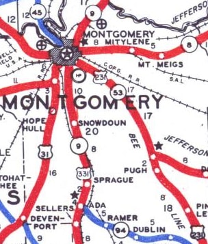
When the US routes were first commissioned in 1926, the north end of US 231 was in Montgomery.  The earliest map I have seen (below) shows US 231 coming in on Woodley Road, which becomes Fairview Avenue.  At Perry Street, US 231 junctioned US 31-80 coming from the opposite direction on Fairview:
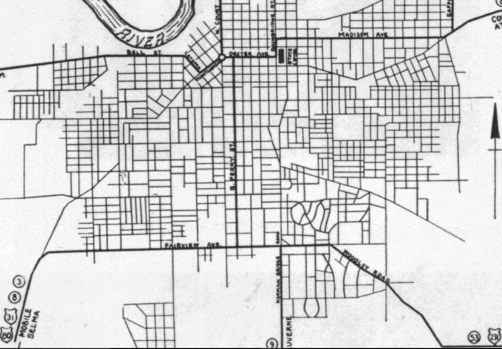
Picture
c. 1936, AL DoT
So US 231 could have ended at that intersection... but that is unlikely.  For reasons explained in more detail below, US 231 probably continued north on Perry with US 31-80, ending at Dexter Avenue.  The perspective in this postcard photo was looking east on Dexter, with the Court Square fountain in the foreground, and the State Capitol visible in the distance:
Picture
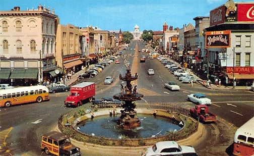
c. 1950s, attribution unknown
Historically, drivers heading toward the Capitol were on southbound US 31, while traffic coming towards the fountain was on westbound US 80.  At the next block ahead (Perry), both routes were directed south (viewer's right).  That intersection also marked the north beginning of US 231.

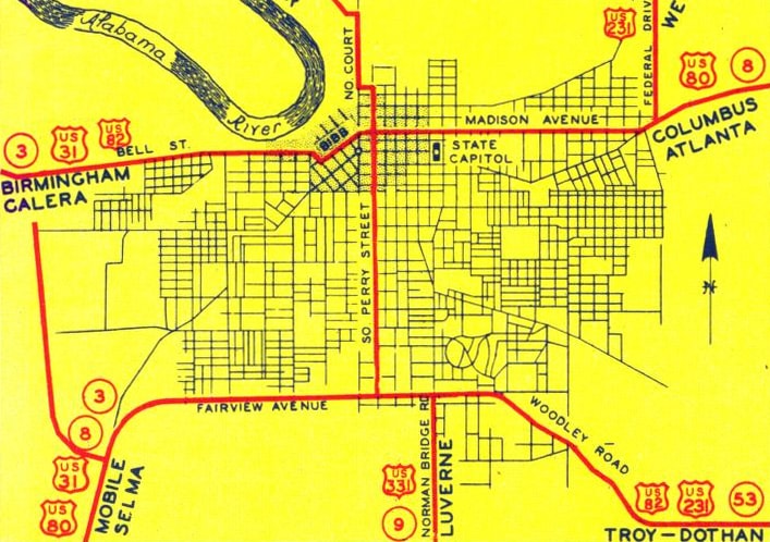
The map above shows that US 80 traffic could go only as far as the Capitol before having to jog north and then resume east on Madison Avenue.  ​That situation was fixed in about 1938, when traffic flow was changed to stay on Madison all the way through to Court Street.  Once that happened, the north end of US 231 was moved two blocks north on Perry, to its junction with Madison:
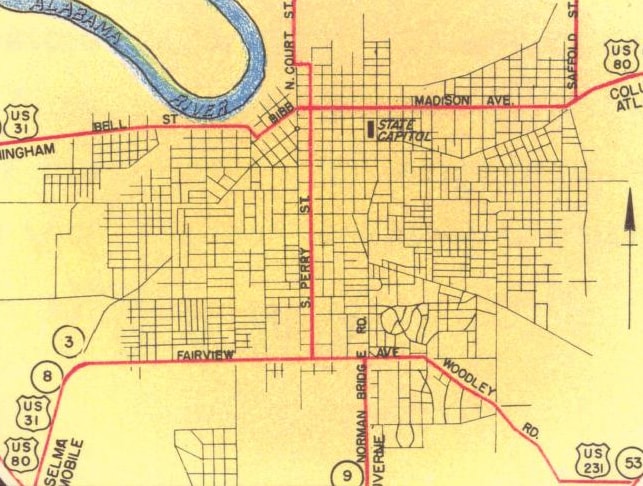
Picture
c. 1939, AL DoT
The last issue of the official state highway map to show US 231 ending in Montgomery was 1952.  The map from the following year showed that US route designations had been applied to the AL hwy. 9 corridor.  US 231 was extended north from Montgomery, while to the south was the brand-new US 331 designation:
Picture
c. 1952, AL DoT
Picture
c. 1953, AL DoT
By that time, nothing had really changed in terms of intra-city highway routes, except for a couple new US route designations, and a bypass around the southwest side of the city:
Picture
c. 1954, AL DoT
Like the earlier maps' lack of clarity with respect to US 231, that one was not explicit in terms of how far north the US 331 designation went into the city.  However, a contemporary USGS map sheds some light on that question.  It indicated that US 331 came in from the south on Norman Bridge Road, then jogged west a couple blocks on Fairview, and then continued north on Perry with several other route designations:
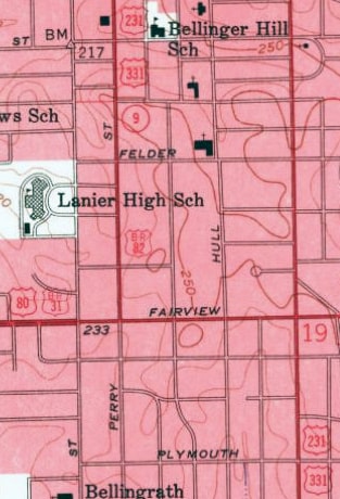
Picture
c. 1958, USGS
During the early years of the US route system, highway designations were commonly overlapped to the central area of the cities they served.  If AL DoT considered it important to do that with US 331 in 1952, then we can be reasonably certain that they had already been doing the same thing with US 231 up until that year.  This photo was taken looking north on Perry at Madison; this was the north end of US 231 from about 1938 to 1952, and then the north end of US 331 starting in 1952, and for about the next 30 years:
Picture
Karners, Apr. 2014
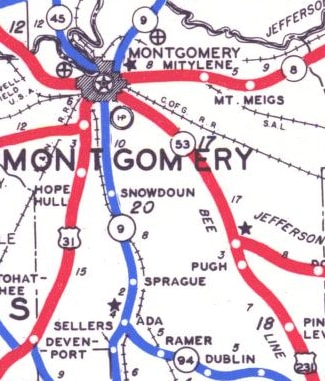
But during those years, highway planners were changing their thinking: bypasses became more common, as cities attempted to keep through traffic out of their congested business districts.  It was not long before all of the Mongomery US routes except US 331 had been moved off Perry and onto bypass routes in order to avoid downtown.  In about 1960, Hull Street became the southbound counterpart to Perry, so US 331 kept the same endpoint, but its north beginning was three blocks east of Perry.  
Get your copy of this epic book that commemorates the first century of the US route system!

In 1979, US 331 was rerouted onto Court Street south of town, but the designation did not end at South Blvd (as it does today).  Rather, US 331 continued east on South Blvd and then north via its old route along Norman Bridge.  The 1983 map showed US 331 still using Fairview to connect between Norman Bridge and Perry/Hull, but the 1985 map was the first to show northbound traffic following Union Street into downtown:
An eyewitness recalls that during that timeframe an "End US 331" sign was posted on Union at Madison... and in fact, until early 2010 there was still a remnant US 331 sign on Union, just north of Washington Avenue:
Picture
Nelson, Sep. 2006
​Decatur Street (two blocks west of Union) carried southbound US 331 traffic.  US 331 was truncated to its current endpoint in 1990, and accordingly the 1991 DoT map was the first issue to clearly indicate that.  Incidentally, as of 2009, most of Norman Bridge Road between Court and Seibles Road was closed to traffic (apparently because its eponymous bridge over Catoma Creek got washed out).  That was still the case as of 2014, so it is unclear whether this former alignment of US 331 is expected to reopen.  If repairing the bridge is deemed unnecessary, then it is likely that segment of Norman Bridge will eventually be vacated.
main US 231 page
main US 331 page
Research and/or photo credits: Adam Froehlig; Karin and Martin Karner; John Lucas; Steven Nelson; Dale Sanderson
Page originally created 1999;
last updated Dec. 18, 2017.

Copyright © 1998-2025
Picture