US Ends .com
  • Home
  • Store
    • US highway map
    • Florida US highway map
  • Endpoints
    • US 1 - US 9 >
      • 1 >
        • 201
        • 301
        • 401 [i]
        • 401 [ii]
        • 401
        • 501
        • 601
        • 701
      • 2w >
        • 102
      • 2e >
        • 202
        • 302
      • 3
      • 4 >
        • 104
      • 5
      • 6 >
        • 106
        • 206
      • 7
      • 8
      • 9 >
        • 109*
        • 209
        • 309
    • US 10 - US 19 >
      • 10 >
        • 110
        • 210
        • 310
        • 410
      • 11 >
        • 111
        • 211
        • 311
        • 411 [i]
        • 411 [ii]
        • 411
        • 511*
        • 611
        • 711*
      • 12 >
        • 112
        • 212
        • 312
      • 13 >
        • 113
        • 213
      • 14
      • 15
      • 16 >
        • 116
        • 216
      • 17 >
        • 17-1
        • 117 [i]
        • 117
        • 217
      • 18 >
        • 118
        • 218
      • 19 >
        • 119
        • 219
        • 319
    • US 20 - US 29 >
      • 20 >
        • 120
        • 220
        • 320
        • 420
      • 21 >
        • 121 [i]
        • 121
        • 221
        • 321
        • 421
        • 521
      • 22 >
        • 122 [i]
        • 122 [ii]
        • 222
        • 322
        • 422e
        • 422w
        • 522
        • 622*
      • 23 >
        • 123 [i]
        • 123
        • 223
      • 24 >
        • 124
        • 224
      • 25
      • 26 >
        • 126
      • 27 >
        • 127
        • 227
      • 28
      • 29 >
        • 129
    • US 30 - US 39 >
      • 30 >
        • 130
        • 230
        • 330
        • 430
        • 530
        • 630*
        • 730
        • 830
      • 31 >
        • 131
        • 231
        • 331 [i]
        • 331
        • 431
      • 32
      • 33
      • 34
      • 35
      • 36 >
        • 136
      • 38 >
        • 138
    • US 40 - US 49 >
      • 40 >
        • 140
        • 240
        • 340
      • 41 >
        • 141
        • 241 [i]
        • 241 [ii]
        • 341
        • 441
        • 541
        • 641
      • 42
      • 43
      • 44
      • 45
      • 46
      • 48 [i]
      • 48 [ii]
      • 48
      • 49
    • US 50 - US 59 >
      • 50 >
        • 150
        • 250
        • 350
        • 450
        • 550
        • 650
      • 51 - 55 >
        • 51 >
          • 151
        • 52 >
          • 152
        • 53
        • 54 >
          • 154
        • 55
      • 56 >
        • 156
      • 57
      • 58 >
        • 158
        • 258
      • 59 >
        • 159
        • 259
    • US 60 - US 69 >
      • 60 >
        • 160
        • 260
        • 360
        • 460
      • 61 - 65 >
        • 61 >
          • 161
        • 62
        • 63 >
          • 163 [i]
        • 64 >
          • 164 [i]
          • 164 [ii]
          • 264
        • 65 >
          • 165
      • 66 >
        • 166
        • 266
        • 366 [i]
        • 366 [ii]
        • 466
        • 566
        • 666
      • 67 >
        • 167
      • 68 >
        • 168
      • 69 >
        • 169
    • US 70 - US 79 >
      • 70 >
        • 170
        • 270 [i]*
        • 270
        • 370
        • 470
      • 71 >
        • 171
        • 271
        • 371 [i]
        • 371
      • 72 - 76 >
        • 72
        • 73
        • 74
        • 75 >
          • 175
          • 275
        • 76 >
          • 176
          • 276
      • 77 >
        • 177
        • 277
        • 377
      • 78 >
        • 178
        • 278
        • 378
      • 79
    • US 80 - US 89 >
      • 80 - 84 >
        • 80 >
          • 180 [i]
          • 180
          • 280
          • 380
        • 81 >
          • 181
          • 281
        • 82
        • 83 >
          • 183
          • 283
          • 383
        • 84
      • 85 - 89 >
        • 85 >
          • 185
          • 285 [i]
          • 285
          • 385 [i]
          • 385
          • 485
        • 87 >
          • 187
          • 287
        • 89 >
          • 189 [i]
          • 189
    • US 90 - US 99 >
      • 90 - 94 >
        • 90 >
          • 190
          • 290
        • 91 >
          • 191
          • 491
        • 92 >
          • 192
        • 93
        • 94
      • 95 -98 >
        • 95 >
          • 195
          • 295
          • 395
        • 96 [i]
        • 96
        • 97 >
          • 197
        • 98
      • 99 >
        • 199
        • 299
        • 399
    • Anomalies >
      • 101
      • 163
      • 400
      • 412
      • 425
  • Places
    • A-L >
      • A >
        • Aberdeen
        • Albuquerque
        • Amarillo
        • Apalachicola
        • Astoria
        • Atlantic
      • B >
        • Baltimore
        • Baton Rouge
        • Bay Area
        • Bishop
        • Boone
        • Brady
        • Bristol
        • Brownsville
        • Brunswick
      • C >
        • Charleston
        • Chattanooga
        • Chicago
        • Cincinnati
        • Cleveland
        • Cody
        • Corpus
        • Cortez
        • Council Bluffs
        • Covington
        • Crescent
        • Cumberland Gap
      • D-E >
        • Dallas
        • Des Moines
        • Detroit
        • Dothan
        • Douglas
        • El Paso
        • Eugene
        • Erie
      • F >
        • Farmington
        • Flagstaff
        • Florence
        • Fox Valley
        • Franklin
      • G >
        • Gallup
        • Grand Junction
        • Grand Portage
        • Grayling
        • Great Falls
        • Greeley
      • H-I >
        • Hardeeville
        • Harrisburg
        • Holbrook
        • Idaho Falls
        • Int'l Falls
      • J-K >
        • Jacksonville
        • Joplin
        • Junction
        • Kansas City
        • Keokuk
        • Key West
        • Kingman
      • L >
        • Laredo
        • Lewiston
        • Long Beach
        • Los Angeles
        • Louisville
        • Lubbock
    • M-R >
      • M >
        • Mackinaw
        • Madison
        • Maryhill
        • Maysville
        • Miami
        • Midway
        • Miles City
        • Milford
        • Milwaukee
        • Minneapolis
        • Mobile 31
        • Mobile 31-43-45
        • Montgomery
        • Monticello
        • Mount Vernon
      • N-O >
        • Nags Head
        • Naples
        • Natchez
        • New Castle
        • New Orleans
        • Niagara
        • Norlina
        • Ocean City
        • Oklahoma City
      • P >
        • Pee Dee
        • Pembina
        • Pensacola
        • Petersburg
        • Philadelphia
        • Piegan
        • Pineville
        • Port Arthur
        • Portsmouth
      • Q-R >
        • Quad Cities
        • Rapid City
        • Raton
        • Reading
        • Richmond
        • Rockingham
        • Rouses Point
    • S-Z >
      • S >
        • San Antonio
        • San Antonio NM
        • San Diego
        • Santa Fe
        • Savannah
        • Sioux
        • Springer
        • Springfield
        • St. Ignace
        • St. John
        • St. Paul
        • St. Pete
      • T-U-V >
        • Tallahassee
        • Tampa
        • Toledo
        • Trinidad
        • Ucolo
        • VA Beach
      • W >
        • Walterboro
        • Waverly
        • West Memphis
        • Wilmington
        • Wilson
        • Wrightsville
      • Y >
        • Yellowstone E
        • Yellowstone N
        • Yellowstone NE
        • Yellowstone S
        • Yellowstone W
  • Highways
    • Map of all endpoints
    • Sources
    • History
    • 1926 almost-routes
    • Intra-state routes
    • Numbering
    • Colors
    • Blog
  • Bonus
    • Colorado >
      • Lowest point
      • Antipodes
      • Toponymy >
        • Roots
      • Colloquialisms
      • Populations
      • Denvers
    • Washington Meridian
    • Watersheds >
      • Headwaters Hill
      • Three Waters Mtn.
      • Parting of the Waters
    • Geo-centers >
      • 48 states
      • 50 states
      • North America
    • State corners >
      • AZ-CO-NM-UT
      • CO-UT-WY
      • CO-NE-WY
      • CO northeast
      • CO-KS-NE
      • CO-KS-OK
      • CO-NM-OK
      • NM-OK-TX
      • NM southeast
      • TX northwest
    • ooss.space
  • Connect
    • Author/history
    • Rationale
    • Contact
    • Contributors
    • Submissions

Philadelphia

Historic US highway endpoints in Philadelphia, PA

1927-1985
Get your very own map showing all current and historic US routes!

In addition to the main US routes that pass through Philadelphia (US 1, 13, and 30), historically some shorter branch routes terminated in the city.  None of these routes extended outside of Pennsylvania.  By 1972 all but one of them had been decommissioned, and in 1985 the last one was truncated to a point outside of Philadelphia city limits.
US 120 was among the routes in the original 1926 plan, and its east terminus was listed as Philadelphia.  However, it was never actually signposted there, because by 1927 its easternmost segment had already been replaced by US 422.  US routes were probably not signed at all in Pennsylvania until 1928, and (according to the original caption accompanying this photo) not in Philadelphia itself until 1931:
Picture
c. 1931 (attribution unknown)
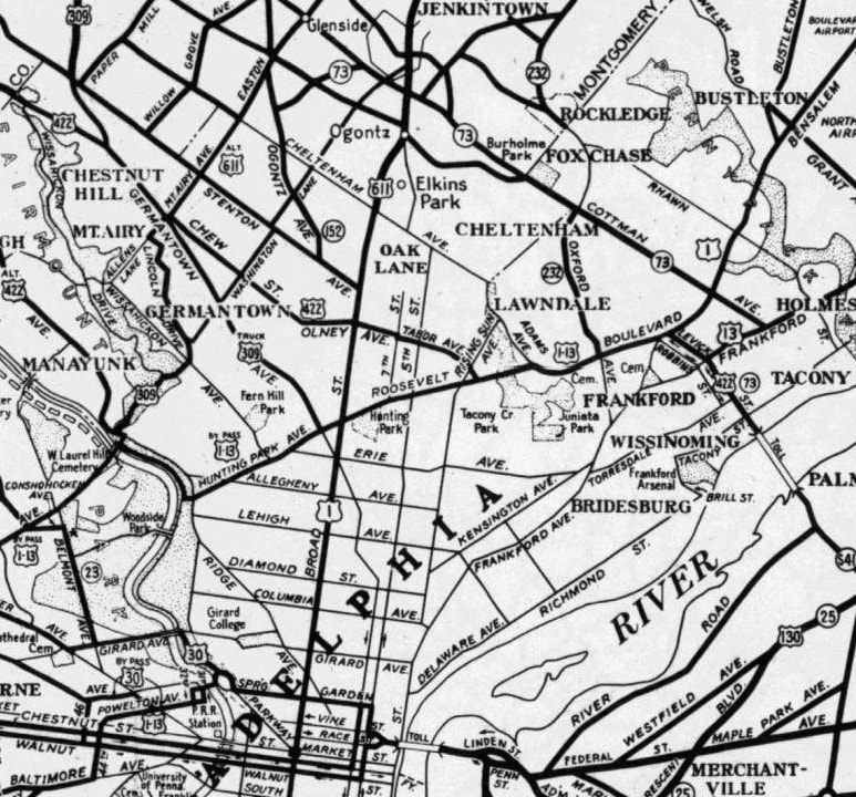
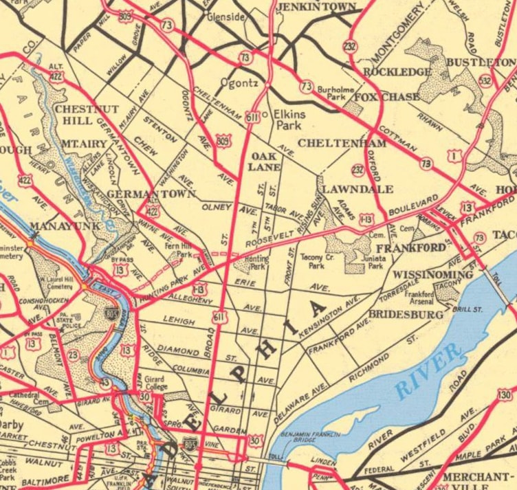
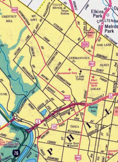
The remaining three routes were all shown on the following map: US 611 and US 309 came in from the north edge, and US 422 is visible at upper left.  But notice that the thick lines (indicating signed highway routes) all became thinner right around the point where they entered the city limits.  That may reflect the fact that PennDoT did not maintain any Philadelphia routes until 1937, and any signs posted during those early years would have been the responsibility of the City.  This makes it a challenging task to identify the specific locations of early endpoints:
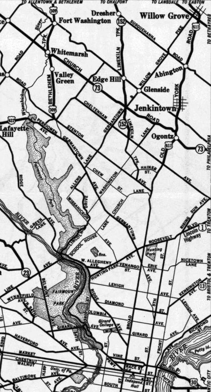
Picture
c. 1930, Penn DoT
We will start with US 611, since it is quite certain that its south end was originally at Penn Square in Philadelphia.  For a time, that appears to have been true even after all other US highways had been rerouted away from the Square (as is shown on other maps below).  Penn Square was a fitting place to end a US route -- it essentially functions as a giant rotary encircling the massive city hall building, and it thus forms the cynosure of Philadelphia:
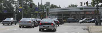
That interactive image is looking south on Broad Street, at the historic south end of US 611.  This photo was heading westbound; Broad exits the Square to the right:
Picture
Field/Nitzman, Aug. 2005
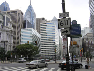
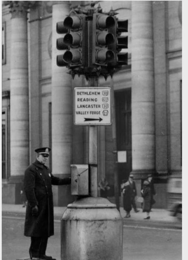
Straight ahead was once southbound US 1-13; northbound was to the right on Broad.  That direction was also the south beginning of US 611.  Until recently, drivers turning that direction would see the first northbound sign:
Picture
Nitzman, May 2007
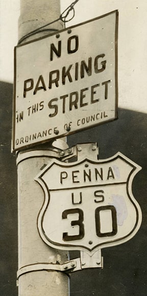
​PA 611 follows historic US 611 northward all the way up through the Poconos.  ​​By the time US 611 was decommissioned in 1972, apparently it had been truncated by a few blocks.  At least according to this agenda item from AASHO's Dec. 1971 meeting minutes, US 611 had been cut back to its junction with US 30, which ran along Vine Street, about five blocks north of City Hall:
Picture
​The other two routes (US 309 and US 422) are harder to determine from maps, although this next photo is very illuminating.  It was taken in 1932 at what was then a six-way intersection of 16th Street, Arch Street, and Ben Franklin Parkway (historically the Parkway extended through what is now Love Park to City Hall).  This sign shows that US 309 and US 422 were initially signed to City Hall (as were US 30 and PA 23).  It was a common practice during the early years of the US highway system to sign all routes to an important building in the city center, and in Philadelphia the obvious choice would have been City Hall:
Picture
c. 1932, attribution unknown
However, it appears that US 309 and US 422 were not signed all the way to City Hall for very long.  I have never seen a map that shows either of those routes going to City Hall.  I suspect this is because Philadelphia was experiencing traffic problems, and already by the early 1930s they were trying to mitigate the issue.  They designated a route along Hunting Park Avenue and City Line Avenue as a bypass for US 1 and US 13, as shown on this next sign.  But notice that it did not even inform drivers that mainline US 1-13 was straight ahead on Broad, providing more evidence of an effort to keep through traffic out of the city center:
Picture
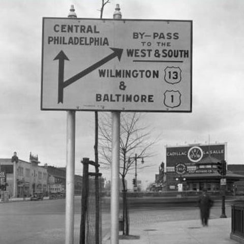
c. 1932 (linked to source)
Maps from the mid-1930s and later suggest that both the US 309 and US 422 designations had been truncated to their intersection with the new US 1-13 bypass:
Picture
c. 1940, Rand McNally (linked to source)
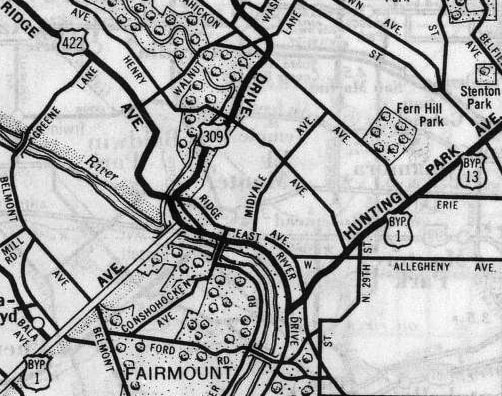
At the intersection of Ridge Avenue and Lincoln Drive, they joined for a brief concurrency, before both routes ended at City Line Avenue.  This is now known as City Av, and the historic junction was located approximately where that intersects Kelly Drive today.  This photo is from roughly that location; it was looking north on City Av, or north on Byp 1-13, which continued via Kelly Dr to Ridge Av South.  US 309 went up Lincoln Dr, while US 422 used Ridge Av North:
Further to the east, that map showed Bypass US 422 aligning with the Tacony-Palmyra Bridge.  In 1946, mainline US 422 was changed to follow that routing to the bridge:
Picture
c. 1950, Penn DoT
The US 422 designation did not enter New Jersey; it ended at the stateline over the Delaware River.  Here is a view of the Bridge from that perspective:
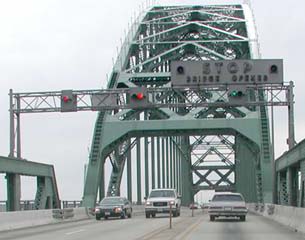
Picture
Mason
That arrangement lasted for less than a decade: in 1954, the routes of both US 422 and US 309 were changed, as illustrated on this next map:
Picture
c. 1956, Gousha (linked to source)
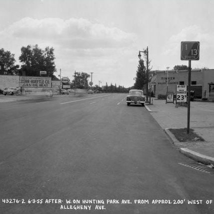
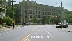
US 422 ended near the old terminus it shared with US 309, except traffic was directed a little further west on Ridge Av and Allegheny Avenue, ending at Hunting Park Avenue (which by that time had become mainline US 1-13).  This image is looking southwest on Hunting Park:
US 1-13 continued straight, but traffic angling to the right on Allegheny was at the east beginning of US 422.
Incidentally, this next photo was taken looking the same direction on Hunting Park, and it shows the area right where that McDonald's is located now.  Note the two-tone US route shield that was posted along this segment shared by US 1 and US 13.  If you have any info about the colors that were used on this sign, and/or information about whether all US routes in Philly were posted with colored shields during this timeframe, please contact US Ends:
Picture
c. 1955 (linked to source)
Meanwhile, US 309 traffic was directed southeast from Chestnut Hill via a new routing along Stenton Avenue, and it ended at its junction with US 611 on Broad:
Picture
Elbert, July 2006
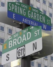
City Hall is about seven miles to the right on Broad.  Stenton is no longer a state highway, but Broad is PA hwy. 611, the number for which is obviously a nod to historic US 611.  Street signs at this intersection include the PA 611 marker...
Picture
Elbert, July 2006
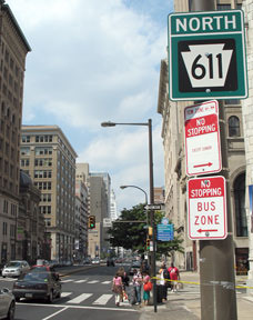
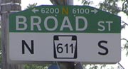
​...but compare that to the "US 611" marker on Broad Street signs about six miles to the south:
Picture
Elbert, July 2006
A map from a few years later showed the same endpoint for US 422... and also for US 309, although traffic had been directed to turn north on Ogontz Avenue (instead of staying on Stenton):
Picture
c. 1960, Penn DoT
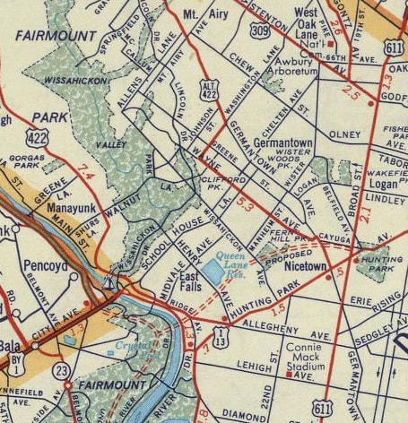
However, the year after that map was made, US 422's terminus was changed again, as illustrated on this map:
Picture
c. 1970, Penn DoT
Now the route came into the city via Germantown Avenue, transitioned to Wayne Avenue, and ended on Clarissa Avenue at Hunting Park:
Picture
Nelson, Sep. 2007
That map illustrated another change, one which AASHTO approved in Oct. 1967: US 309 was decommissioned and replaced with the PA 309 designation.  Then in 1972, US 611 was replaced with PA 611.  Finally, in 1985, US 422 was truncated to its current endpoint outside Philadelphia, and since then no US routes terminate in the city.
main US 120 page
main US 309 page
main US 422 page
main US 611 page
Research and/or photo credits: Nathan Edgars; Chris Elbert; Andy Field; Christopher Mason; Steven Nelson; Alex Nitzman; Dale Sanderson; "fdocbc"
Page originally created 1999;
last updated Feb. 13, 2020.
Copyright © 1998-2023
Picture