US Ends .com
  • Home
  • Store
    • US highway map
    • Florida US highway map
  • Endpoints
    • US 1 - US 9 >
      • 1 >
        • 201
        • 301
        • 401 [i]
        • 401 [ii]
        • 401
        • 501
        • 601
        • 701
      • 2w >
        • 102
      • 2e >
        • 202
        • 302
      • 3
      • 4 >
        • 104
      • 5
      • 6 >
        • 106
        • 206
      • 7
      • 8
      • 9 >
        • 109*
        • 209
        • 309
    • US 10 - US 19 >
      • 10 >
        • 110
        • 210
        • 310
        • 410
      • 11 >
        • 111
        • 211
        • 311
        • 411 [i]
        • 411 [ii]
        • 411
        • 511*
        • 611
        • 711*
      • 12 >
        • 112
        • 212
        • 312
      • 13 >
        • 113
        • 213
      • 14
      • 15
      • 16 >
        • 116
        • 216
      • 17 >
        • 17-1
        • 117 [i]
        • 117
        • 217
      • 18 >
        • 118
        • 218
      • 19 >
        • 119
        • 219
        • 319
    • US 20 - US 29 >
      • 20e >
        • 120
        • 220
        • 320
        • 420
      • 20w
      • 21 >
        • 121 [i]
        • 121
        • 221
        • 321
        • 421
        • 521
      • 22 >
        • 122 [i]
        • 122 [ii]
        • 222
        • 322
        • 422e
        • 422w
        • 522
        • 622*
      • 23 >
        • 123 [i]
        • 123
        • 223
      • 24 >
        • 124
        • 224
      • 25
      • 26 >
        • 126
      • 27 >
        • 127
        • 227
      • 28
      • 29 >
        • 129
    • US 30 - US 39 >
      • 30 >
        • 130
        • 230
        • 330
        • 430
        • 530
        • 630*
        • 730
        • 830
      • 31 >
        • 131
        • 231
        • 331 [i]
        • 331
        • 431
      • 32
      • 33
      • 34
      • 35
      • 36 >
        • 136
      • 38 >
        • 138
    • US 40 - US 49 >
      • 40 >
        • 140
        • 240
        • 340
      • 41 >
        • 141
        • 241 [i]
        • 241 [ii]
        • 341
        • 441 >
          • 441n
          • 441s
        • 541
        • 641
      • 42
      • 43
      • 44
      • 45
      • 46
      • 48 [i]
      • 48 [ii]
      • 48
      • 49
    • US 50 - US 59 >
      • 50 >
        • 150
        • 250
        • 350
        • 450
        • 550
        • 650
      • 51 - 55 >
        • 51 >
          • 151
        • 52 >
          • 152
        • 53
        • 54 >
          • 154
        • 55
      • 56 >
        • 156
      • 57
      • 58 >
        • 158
        • 258
      • 59 >
        • 159
        • 259
    • US 60 - US 69 >
      • 60 >
        • 160
        • 260
        • 360
        • 460
      • 61 - 65 >
        • 61 >
          • 161
        • 62
        • 63 >
          • 163 [i]
        • 64 >
          • 164 [i]
          • 164 [ii]
          • 264
        • 65 >
          • 165
      • 66 >
        • 166
        • 266
        • 366 [i]
        • 366 [ii]
        • 466
        • 566
        • 666
      • 67 >
        • 167
      • 68 >
        • 168
      • 69 >
        • 169
    • US 70 - US 79 >
      • 70 >
        • 170
        • 270 [i]*
        • 270
        • 370
        • 470
      • 71 >
        • 171
        • 271
        • 371 [i]
        • 371
      • 72 - 76 >
        • 72
        • 73
        • 74
        • 75 >
          • 175
          • 275
        • 76 >
          • 176
          • 276
      • 77 >
        • 177
        • 277
        • 377
      • 78 >
        • 178
        • 278
        • 378
      • 79
    • US 80 - US 89 >
      • 80 - 84 >
        • 80 >
          • 180 [i]
          • 180
          • 280
          • 380
        • 81 >
          • 181
          • 281
        • 82
        • 83 >
          • 183
          • 283
          • 383
        • 84
      • 85 - 89 >
        • 85 >
          • 185
          • 285 [i]
          • 285
          • 385 [i]
          • 385
          • 485
        • 87 >
          • 187
          • 287n
          • 287s
        • 89n
        • 89s >
          • 189 [i]
          • 189
    • US 90 - US 99 >
      • 90 - 94 >
        • 90 >
          • 190
          • 290
        • 91 >
          • 191 >
            • 191n
            • 191s
          • 491
        • 92 >
          • 192
        • 93
        • 94
      • 95 -98 >
        • 95 >
          • 195
          • 295
          • 395
        • 96 [i]
        • 96
        • 97 >
          • 197
        • 98
      • 99 >
        • 199
        • 299
        • 399
    • Anomalies >
      • 101
      • 163
      • 400
      • 412
      • 425
  • Places
    • A-L >
      • A >
        • Aberdeen
        • Albuquerque
        • Amarillo
        • Apalachicola
        • Astoria
        • Atlantic
      • B >
        • Baltimore
        • Baton Rouge
        • Bay Area
        • Bishop
        • Boone
        • Brady
        • Bristol
        • Brownsville
        • Brunswick
      • C >
        • Charleston
        • Chattanooga
        • Chicago
        • Cincinnati
        • Cleveland
        • Cody
        • Corpus
        • Cortez
        • Council Bluffs
        • Covington
        • Crescent
        • Cumberland Gap
      • D-E >
        • Dallas
        • Des Moines
        • Detroit
        • Dothan
        • Douglas
        • El Paso
        • Eugene
        • Erie
      • F >
        • Farmington
        • Flagstaff
        • Florence
        • Fox Valley
        • Franklin
      • G >
        • Gallup
        • Georgetown
        • Grand Junction
        • Grand Portage
        • Grayling
        • Great Falls
        • Greeley
      • H-I >
        • Hardeeville
        • Harrisburg
        • Holbrook
        • Idaho Falls
        • Int'l Falls
      • J-K >
        • Jacksonville
        • Joplin
        • Junction
        • Kansas City
        • Keokuk
        • Key West
        • Kingman
      • L >
        • Laredo
        • Lewiston
        • Long Beach
        • Los Angeles
        • Louisville
        • Lubbock
    • M-R >
      • M >
        • Mackinaw
        • Madison
        • Maryhill
        • Maysville
        • Miami
        • Midway
        • Miles City
        • Milford
        • Milwaukee
        • Minneapolis
        • Mobile 31
        • Mobile 31-43-45
        • Montgomery
        • Monticello
        • Mount Vernon
      • N-O >
        • Nags Head
        • Naples
        • Natchez
        • New Castle
        • New Orleans
        • Niagara
        • Norlina
        • Ocean City
        • Oklahoma City
      • P >
        • Pee Dee
        • Pembina
        • Pensacola
        • Petersburg
        • Philadelphia
        • Piegan
        • Pineville
        • Port Arthur
        • Portsmouth
      • Q-R >
        • Quad Cities
        • Rapid City
        • Raton
        • Reading
        • Richmond
        • Rockingham
        • Rouses Point
    • S-Z >
      • S >
        • San Antonio
        • San Antonio NM
        • San Diego
        • Santa Fe
        • Savannah
        • Sioux
        • Springer
        • Springfield
        • St. Ignace
        • St. John
        • St. Paul
        • St. Pete
      • T-U-V >
        • Tallahassee
        • Tampa
        • Toledo
        • Trinidad
        • Ucolo
        • VA Beach
      • W >
        • Walterboro
        • Waverly
        • West Memphis
        • Wilmington
        • Wilson
        • Wrightsville
      • Y >
        • Yellowstone E
        • Yellowstone N
        • Yellowstone NE
        • Yellowstone S
        • Yellowstone W
  • Highways
    • Map of all endpoints
    • Sources
    • History
    • 1926 almost-routes
    • Intra-state routes
    • Numbering
    • Colors
    • Gaps
    • Blog
  • Bonus
    • Colorado >
      • Lowest point
      • Antipodes
      • Toponymy >
        • Roots
      • Colloquialisms
      • Populations
      • Denvers
    • Washington Meridian
    • Watersheds >
      • Headwaters Hill
      • Three Waters Mtn.
      • Parting of the Waters
    • Geo-centers >
      • 48 states
      • 50 states
      • North America
    • State corners >
      • AZ-CO-NM-UT
      • CO-UT-WY
      • CO-NE-WY
      • CO northeast
      • CO-KS-NE
      • CO-KS-OK
      • CO-NM-OK
      • NM-OK-TX
      • NM southeast
      • TX northwest
    • ooss.space
  • Connect
    • Author/history
    • Rationale
    • Contact
    • Contributors
    • Submissions

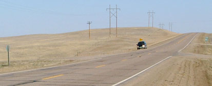
End of US highway 14

View a map showing this route.
Get your very own map showing all current and historic US routes!
Picture
Summa
Picture
Summa
1926-1928
  • East: Winona, MN
  • West: Philip Jct. SD
1928-1934
  • East: Winona, MN
  • West: Rapid City, SD
1934-1938
  • East: Chicago, IL
  • West: Cody, WY
1938-present
  • East: Chicago, IL
  • West: Yellowstone, WY
Mileage: in 1989 AASHTO listed a figure of 1546 miles for US 14... however, that included the mileage of US 14's alternate routes.  According to the state subtotals on AASHTO's 1989 spreadsheet, mainline US 14's actual end-to-end total at the time was 1398 miles.  That closely matches our own 2020 measurement, which yielded 1395.1 miles (reroutings and realignments likely explain the difference).  At US 14's maximum historical extent (when it continued to downtown Chicago) it was 1402.6 miles long.

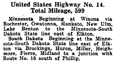
US 14 was an original 1926 route, but at the time it was significantly shorter than it is today.  This excerpt is from AASHO's April 1927 route log:
Picture

Initially the east end of US 14 was at its junction with US 61 in Winona:
Picture
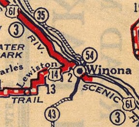
c. 1927, Rand McNally
This photo is looking south on modern US 61, ​and although this junction serves as today's functional equivalent, this is a newer bypass of sorts around Winona, and it had not yet been built back when US 14 ended here:
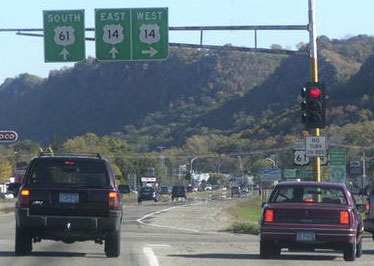
Picture
Teresco, Oct. 2004
Originally US 61 followed what is now CR 32 through Goodview, but shortly after entering Winona it curved to head east on 6th Street (or Broadway).  That curve has since been vacated, but most of the old concrete roadway still exists.  Meanwhile, US 14 split off today's route by going east on Gilmore Street (via a bridge that no longer exists), then north on Vila, ending at Broadway (US 61).  This photo was looking south on Vila: 
Picture
Grier, July 2006
US 61 traffic used the crossroad (Broadway/6th), and the east beginning of US 14 was straight ahead.  (Incidentally, the bluffs visible in the background mark the edge of the Mississippi River floodplain, in which Winona is situated.)  That lasted only about two years; in 1929 the remainder of today's CR 32 was built: Junction Street down to Gilmore.  US 61 was rerouted to follow that, then east on Gilmore, and then 13th Street (or Sarnia Street).  So US 14 was truncated by about a mile, ending on Gilmore at Junction.  This photo was looking west on Gilmore:
Picture
Munsch, Oct. 2007
That was northbound US 61, which curved to the right on Junction.  Straight ahead was the east beginning of US 14 until 1933.  After that, US 14 was extended eastward via southbound US 61.  The two routes do not diverge again until Readstown WI (about 76 miles distant).  
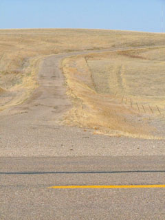
Early maps make it look like no one quite knew what to do with the west end of US 14: it was not until 1934 that it was assigned a routing through the Black Hills distinct from US 16 (or more accurately, US 16 was rerouted to go through the Hills, while US 14 was given US 16's old path around the north edge of the Hills).  But before that, US 14 ended at a lonely junction with US 16 outside Philip:
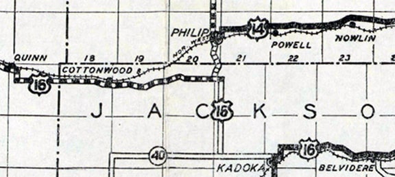
Picture
c. 1927, SDDoT
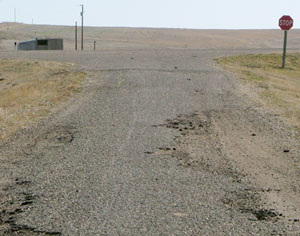
This photo was looking south on today's SD hwy. 73, about 5 miles south of Philip, at an intersection which on some maps is marked as "Philip Junction":
Picture
Sanderson, Mar. 2004
That was the original west end of US 14 -- straight ahead was eastbound US 16, and westbound US 16 was to the right.  Next we are looking the opposite direction:
Picture
Sanderson, Mar. 2004
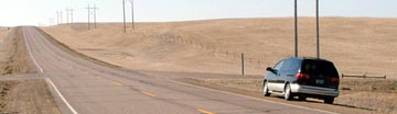
A "North SD 73" marker is just visible on the right edge.  Westbound US 16 continued to the left here, while US 14 began straight ahead.  Some maps make it look like old US 16 west from here is a good quality road, but that is actually not the case:
Picture
Sanderson, Mar. 2004
That was looking west; the yellow center stripe in the foreground is on SD 73 (US 16 was to the left and straight ahead; US 14 was to the right).  The raised roadbed serves as evidence that this was once a highway.  But it is in pretty lousy condition now; the road sign was decaying in the borrow ditch along the right side:
Picture
Sanderson, Mar. 2004
Here is what old US 16 looked like heading the opposite direction; eastbound US 16 continued to the right, and US 14 began to the left:
Picture
Sanderson, Mar. 2004

That lasted only a couple years.  Already by about 1928 US 14 had been extended west with US 16 to a new endpoint in Rapid City.  ​In 1934 the west end of US 14 was extended to Cody.  In 1938 US 14 was extended west again, this time to the east entrance of Yellowstone National Park, where the terminus remains to this day. 
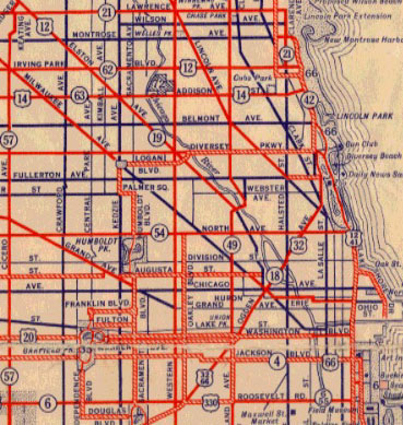
Also in 1934 the east end of US 14 was extended to Chicago.  Traffic came in on Addison Street, and state highway maps from 1934 through 1938 indicate that US 14 ended at its junction with US 12-41 (Lake Shore Drive):
Picture
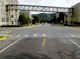
This photo was looking east on Addison at Lake Shore, at the original Chicago endpoint of US 14 :
Picture
Hargraves
This shot is a view up westbound Addison, at the former beginning of US 14:
Picture
Hargraves
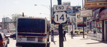
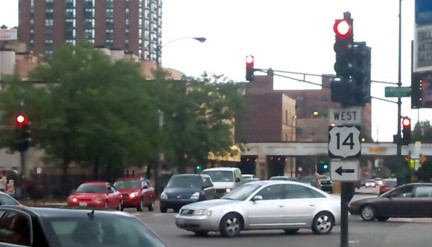
However, that was the arrangement for only about four years.  The 1939 map shows US 14 coming in on Broadway and ending at Foster Avenue:  same intersection where US 14 ends today.  But it should be noted: that junction has not been a continuous endpoint since 1939.  The first time, US 14 ended there only until 1952.  The 1953 map shows that US 14 had been extended down to a common endpoint with US 54 (photos and more info on the Chicago page).  ​That was the case until 1978, which is when AASHTO approved the truncation of US 14 back to its Broadway/Foster endpoint, where it remains to this day:
Picture
Picture
Osbaldeston, Jun. 2000 (removed in 2016)
Picture
Morrison, Oct. 2016
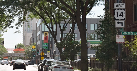
That was looking south on Broadway at Foster.  This photo was taken looking east on Foster...
Picture
Majewski, Aug. 2011
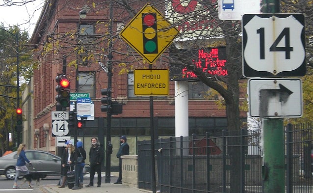
...but that sign was removed in 2018.  As of 2022, the only indication that US 14 begins to the left on Broadway was a sign posted a block before the intersection:
Picture
Nitzman, Jun. 2022
Next we are heading the opposite direction (west on Foster):
Picture
Morrison, Oct. 2016
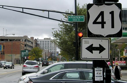
If a driver turns right there on Broadway, they are at the east beginning of US 14, and they are greeted with the sign shown in these photos:
Picture
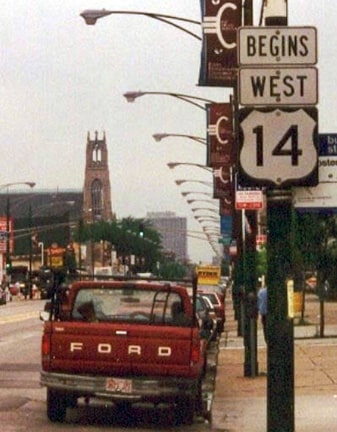
Mortell, summer 1996
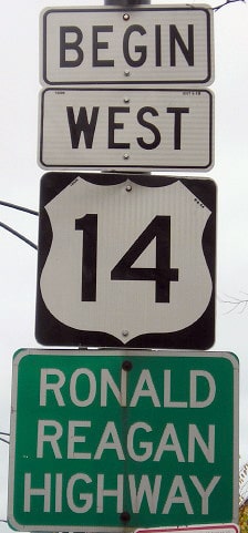
Picture
Morrison, Oct. 2016
That is kind of an odd US highway intersection, because at that point the north-south US 41 runs east-west, while the east-west US 14 runs north-south.  Also, if a driver keeps following US 14 from there, they will intersect US 41 again in a couple miles. 

Research and/or photo credits: Monte Castleman; Tom Grier; Don Hargraves; Matt Majewski; Jeff Morrison; Robert Mortell; Andrew Munsch; Alex Nitzman; Greg Osbaldeston; Dale Sanderson; Michael Summa; Jim Teresco
Page originally created 2001;
last updated Jul. 22, 2022.
Copyright © 1998-2023
Picture