End of US highway 13 |
 |
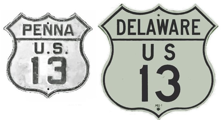
Summa
|
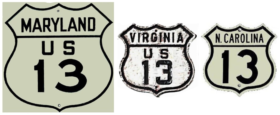
Summa
|
|
1926-1943
|
1943-1951
|
1951-1956
|
1956-1961
|
1961-present
|
|
Mileage: in 1989 AASHTO listed a figure of 569 miles for US 13... however, that included the mileage of US 13's associated business/bypass/alternate routes. According to the state subtotals on AASHTO's 1989 spreadsheet, mainline US 13's actual end-to-end total at the time was 526 miles. That closely matches our own 2020 measurement, which yielded 527 miles.
|
|
|
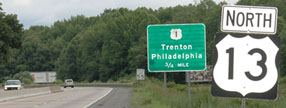
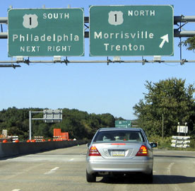
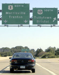
US 13 has been around since the beginning, and its north end has always been in Morrisville, just across the river from Trenton NJ. However, originally the endpoint was at a slightly different location: US 13 was formerly routed into town via the Bristol Pike, then Pennsylvania Avenue, ending at US 1, which was on Bridge Street. This shot was looking south on Pennsylvania; the crossroad is Bridge, so straight ahead was the north beginning of US 13 for 37 years:
|
walmond217, Aug. 2002
|
|
Today both US 1 and US 13 have been rerouted. Shown in this photo is the last northbound US 13 marker:
|
Watkins, June 2006
|
|
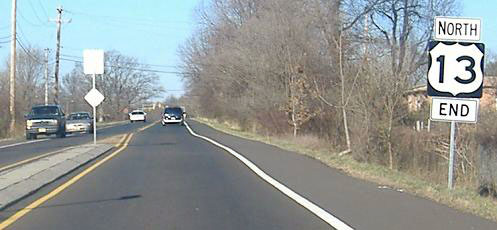
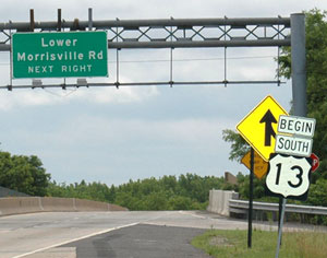
The US 13 designation ends at US 1, just ahead. Signage at that junction is shown here:
|
*, October 2004
|
|
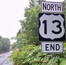
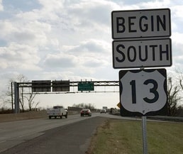
After the exit to southbound US 1, the "End" assembly pictured here was formerly posted beyond the merge point where westbound Lincoln Highway traffic merges onto northbound Pine Grove Road...
|
Alpert, Dec. 2006
|
|
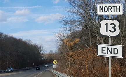
...but later it was moved a bit further south, such that traffic from westbound Lincoln Hwy no longer sees it:
|
Karners, Jul. 2010
|
Ivy/Nitzman, Dec. 2017
|
|
It appears the oversized US 13 shield was replaced with a standard size shield, but the gap left between the tab signs was allowed to remain.
Here we are on northbound US 1 (which is actually heading east at this point), at the exit for the north beginning of US 13: |
*, October 2004
|
The end of that ramp to US 13 is visible in this photo:
Watkins, June 2006
|
|
That was looking south on Pine Grove Road, which becomes US 13 at the US 1 interchange. Here again, the oversized US 13 shield has since been replaced:
|
Ivy/Nitzman, Dec. 2017
|
|
Originally southbound US 13 dead-ended in Cape Charles. It followed the routing of today's VA hwy. 184, coming in on Randolph Avenue, then dropping south one block on Fig Street and continuing west again on Mason Avenue (which is shown at the bottom of this map). At Bay Avenue, US 13 went north, and then back east on Washington Avenue, ending at the next intersection (Pine Street):
|
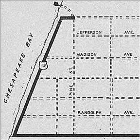
c. 1936, VADoT
|
|
It is unclear why US 13 followed that routing, considering that the ferry to Norfolk likely would have been on the south side of town. This photo shows the historic endpoint:
|
Roberson, Apr. 2007
|
|
That was looking east on Washington; Pine is to the right, and US 13 ended at this intersection. This photo was looking the opposite direction, showing the original beginning of US 13. The route turned to the left on Bay and spiraled around the town before ultimately heading to the right (north) a few miles behind the camera:
|
Roberson, Apr. 2007
|
|
In 1943 the US 13 designation was extended south to Norfolk via the ferry (which continued to operate until 1964), and from the landing at Little Creek, it circled around on Military Highway, ending in Bowers Hill at a grade-separated interchange with US 58. That arrangement was illustrated on this map, although US 13 was incorrectly labeled as SH 13:
|
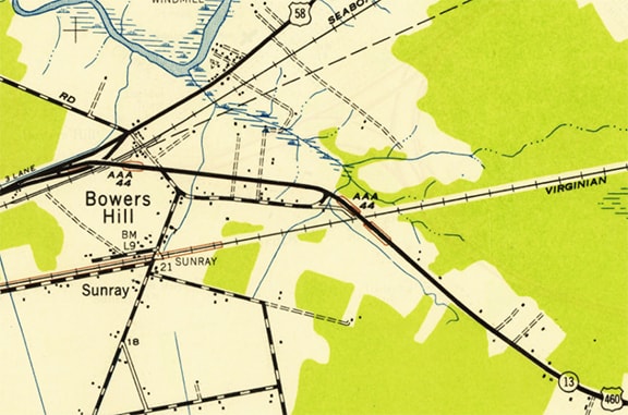
c. 1952, USGS
|
|
Although this photo was taken a few years after US 13 had been extended further south from Bowers Hill, it effectively illustrates how signage looked during the time that US 13 began there. This was looking east on US 58-460, along what is now called West Military Highway. At this fork, the routes diverged, with US 58 keeping to the right (which allowed traffic to continue straight ahead along the railroad, aligning with what is now called Airline Boulevard). The left fork led to a bridge approach, which in the background curved to the right and crossed over both US 58 and the railroad. That fork was also the south beginning of US 13:
|
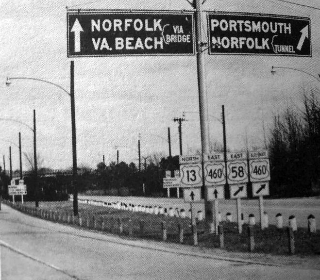
c. 1957, Virginia Highways Bulletin
|
|
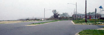
Bowers Hill is now within the city limits of Chesapeake, and the road fork shown above no longer exists. I-664 was built just to the north, and West Military Hwy. was slightly realigned just to the south. That historic junction, situated between the two modern roadways, was completely erased. Today, just to the east of the historic junction is an intersection that marks a turn in the current routings of US 13 and US 460. This current junction serves as the functional equivalent of the historic junction, and directional signage posted for traffic heading eastbound is the current version of the historic sign assembly shown above. To the right on South Military Highway was essentially the historic south beginning of US 13:
|
Karners, Jan. 2017
|
|
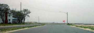
At far left a section of the I-664 overpass is visible. It would be more accurate if that sign said "TO US 58", since straight ahead is how one connects not only to westbound, but to eastbound as well.
Looking the opposite direction (west on West Military), to the left was essentially the south beginning of US 13 for about a decade, but a little further in the distance is where the historic terminus was actually located: |

Karners, Jan. 2017
|
|
This perspective was taken looking west on South Military, showing the junction that represents the historic south end of US 13:
|
Karners, Jan. 2017
|
|
That was the case until 1951, when the US 13 designation was extended south to US 17 at Windsor:
c. 1956, Gousha
|
In this photo, we are looking southeast on King Street at Granville Street. Straight ahead was northbound US 17, while southbound was to the right, so this intersection marked the south end of US 13...
Karners, Jan. 2017
...but only for three years. In 1956, US 13 was extended again, this time to Goldsboro. Traffic then (as today) was directed into town via Berkeley Boulevard, and then west on the bypass...
|
|
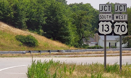
...but until 1961, US 13 ended at its junction with US 117. At the time, US 117 had an at-grade intersection with the bypass. The current grade-separated partial interchange was completed in 1972, and it is not accessible to westbound traffic (which instead must use the William Street exit), so today there is not much to photograph at the historic endpoint. This photo was taken looking south on US 117, which continues to the right. Historically US 13 began to the left, concurrent with eastbound US 70:
|
Sanderson, Jun. 2019
|
|
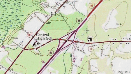
Finally, after I-95 was built, US 13 was extended to interchange 58 at Eastover (which is just north of Fayetteville, but US 13 has never been extended as far south as that city). The topo map in this animated image shows how the interchange was configured prior to the Fayetteville Outer Loop (FOL), while the aerial photo shows how it changed after the northern segment of that freeway was built:
|
|
|
Despite the changes, the US 13 designation still ends in essentially the same place, although the view at this terminus changed a lot with the completion of the FOL. Heading west on southbound US 13, historically there was no "End" sign at the I-95 interchange. But after crossing the overpass, there were no more US 13 markers; instead there was simply this "To US 301" assembly:
|
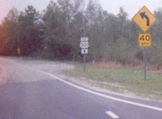
Prince, 2000
|
|
At the time, the junction with US 301 was less than 1/2 mile ahead, but for some reason the US 13 designation was never extended to that point. Instead, it was NC hwy. 1863 that connected I-95 to US 301, as can be seen in this photo:
|
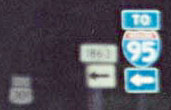
Nitzman, 2001
|
|
That was looking south on US 301. If a driver turned left, they would soon reach the I-95 interchange, as well as the south beginning of US 13, and there the first northbound US 13 sign was posted:
|
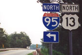
Nitzman, 2001
|
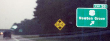
The I-95 exit for the south beginning of US 13 has seen significant changes over the years:
Nitzman, 2001
|
Google Maps Street View, Jul. 2013
|

Google Maps Street View, Jul. 2015
|
|
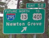
It is interesting that sign references US 401, but there are no further directions to that route. Instead, when drivers exit, they see a reference to US 301:
|

Google Maps Street View, 2012
|
US 301 closely parallels I-95 in this area, which means US 301 is actually situated to the left. And indeed, drivers were historically able to get there by turning left... but when the FOL was built, it was given a grade separation over US 301 with no access. So now if one turns left onto the FOL, they will fly right over US 301, and eventually end up at an interchange with US 401 (which for some reason is not mentioned on that off-ramp). But if a traveler wants US 301, they must first turn right on US 13, then south on Pembroke Lane, which curves back to the west, flies over I-95, and finally connects with US 301.
|
|
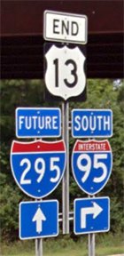
But all that is beginning to stray from the fact that this interchange also marks the south terminus of US 13, which begins to the right... and, heading the opposite direction, its endpoint is now signed:
|

Osbaldeston, May 2008
|
GMSV, Jul. 2013
|
GMSV, Jul. 2015
|
|
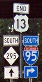
Initially the FOL was signed as "Future I-295", but in 2014 or '15 signage was changed to reference NC 295. Either way, US 13 ends where the FOL begins. Looking the opposite direction (eastbound at the end of the FOL), the beginning of US 13 is signed thus:
|

aaroads.com, May 2007
|
Starting sometime before 1968, NC and SC petitioned AASHO to extend US 13 further southwest through both of those states, but at least three times between then and 1969 the request was denied; more info on this page.
Research and/or photo credits: Steve Alpert; *Carter Buchanan; *Lou Corsaro; Brent Ivy; Karin and Martin Karner; *Doug Kerr; *Alex Nitzman; Greg Osbaldeston; Adam Prince; Mike Roberson; Dale Sanderson; Michael Summa; Mac Watkins; "walmond217"
Page originally created 2000;
last updated Dec. 15, 2023.
last updated Dec. 15, 2023.
