End of historic US highway 485
|
|
US 485 was one of the original 1926 routes, essentially serving as an alternate route for US 85 between Raton and Santa Fe. It split off from US 85 near Raton and followed what is now US 64 to Taos; NM hwy. 68 from Taos to Espanola; and modern US 84-285 to its south end in Santa Fe:
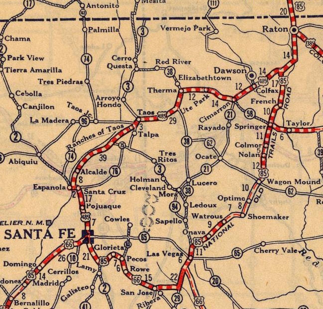
c. 1927, Rand McNally
|
The north end of US 485 was in or near Raton. Today, I-25 follows a direct route southward from there to Maxwell. But US 85 did not always follow that alignment -- originally it was routed along what is now US 64 south and west of Raton, and then modern NM hwy. 445 due south to Maxwell. In fact, a historical marker in the area has a map that still shows US 85 on its historic routing:
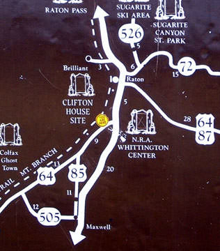
Sanderson, Mar. 2005
|
|
New Mexico has decommissioned US 85 throughout the entire state, and for years now, the junction shown above as US 64 / US 85 has actually been the junction of US 64 / NM 445. It is referred to as "Hoxie Jct" on some maps -- there is nothing there, but it is an interesting place because the former highway alignments are still visible. This photo was heading out of Raton, looking west on US 64:
|
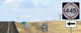
Sanderson, Mar. 2005
|
|
Historically that was southbound US 85, which curved to the left via NM 445. Looking that direction, the curve that US 85 formerly followed is visible:
|
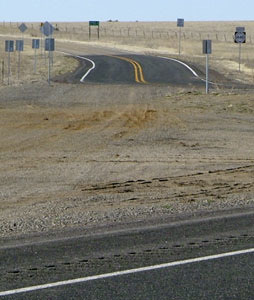
Sanderson, Mar. 2005
|
Southbound US 85 continued that direction, while US 485 either began or split off to the right via today's westbound US 64. This view was at the north end of NM 445:
|
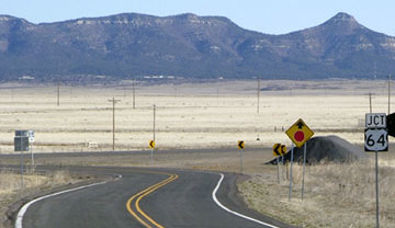
Sanderson, Mar. 2005
|
|
That was formerly northbound US 85, which continued on the curve to the right until it joined what is now eastbound US 64. But it is clear that US 64 is the mainline today, and NM 445 curves back to the left to meet it at a perpendicular angle. Here, we are looking east on US 64:
|
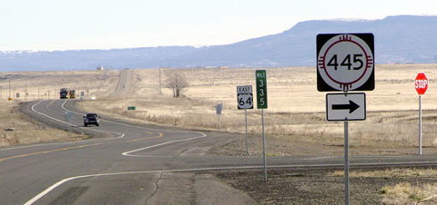
Sanderson, Mar. 2005
|
That was once northbound US 485. Southbound US 85 came towards the camera, and then continued on the curve to the right onto what is now NM 445. I have not seen a map detailed enough to answer whether US 485 ended here at its junction with US 85, or if it overlapped with US 85 ahead into Raton. If it did continue ahead, then it would have shared a common terminus with historic US 385 [i]; more info on the Raton page. US 485 was decommissioned when US 64 was signed along its route in 1931.
Research and/or photo credits: Dale Sanderson; Michael Summa
Page originally created 2002;
last updated Dec. 29, 2021.
last updated Dec. 29, 2021.
