|
The original US routes were officially adopted on November 11, 1926. The main purpose of this page is to explain why some of the routes approved at that time were almost certainly never signposted by the states.
|
|
More broadly, this page also reviews the source material available for the study of US routes during the nascent years of the system. And it demonstrates that the 1926 list was by no means "final". Rather, ongoing changes and refinements continued to be made, some of which were implemented within just weeks or months after the inaugural routes were approved.
Sources
In October 1925 the Bureau of Public Roads (a division of the Department of Agriculture) published a list of proposed US route designations (available here). In some cases it is instructive to refer to that 1925 preliminary list, even though several significant changes took place prior to November 1926, when the final list was approved. To my knowledge at the time of this writing, there is no publicly-accessible list of the US routes that were approved in Nov. 1926. However, we do have a map (full version available here).
|
This map was created with the involvement of the American Association of State Highway Officials, the Department of Agriculture, and the Bureau of Public Roads (now the Federal Highway Administration). The cartographer started with a USGS basemap of the 48 states, and overlaid in red the US routes that were approved in Nov. 1926, as indicated in the map title:
|
The pre-existing basemap already included the names of each state capital, as well as some of the major cities. However, the roman font used for those cities was different than the italic font used for the majority of placenames on the map. Also, some of the toponyms that were included would not normally have been shown on a map of such small scale, indicating that they were important only for the specific purpose of the map. Some examples include Ft. Kent ME (north terminus of US 1), Van Horn TX (west terminus of US 90), Midland SD (west terminus of US 14), Belfield ND (junction of US 10 and US 85), and Armington MT (where US 87 split into US 87E and US 87W). All of this suggests that most placenames were added by the cartographer who produced the AASHO map (in addition to the red highway lines and US route numbers). Although we have only this map (and not a list) of the US routes that were approved in Nov. 1926, we do have a list that was printed about five months later in this publication:
Comparison
The full 1927 list can be viewed here. When comparing this list to the 1926 AASHO map, one finds that the two match almost perfectly. Only a few highways were different. The majority of those were in Pennsylvania, and that is likely explained by the late objections and requests from officials in that state (as detailed here).
Pennsylvania
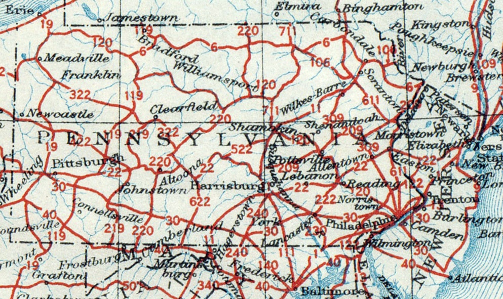
Below is a clip from the 1926 map, showing the US routes that were originally approved in Pennsylvania:
Differences between that 1926 map and the 1927 list:
- US 6 and US 120: the 1926 map showed US 120 between Philadelphia and Erie. US 6 was shown between Matamoras and Kane, where it ended at its junction with US 120. But the 1927 list had US 6 extending both east (to Kingston NY) and west (to Erie). And the west end of US 120 had been truncated to Ridgway, at its junction with "US 119" (which was actually US 219; see next entry).
- US 119 and US 219: the 1926 map showed US 119 from Morgantown WV, through DuBois PA, to the NY state line near Bradford. US 219 was shown between Grantsville MD and DuBois, where it ended at its junction with US 119. But the 1927 list had US 119 ending in DuBois at its junction with US 219. And it was US 219 that continued north to Bradford.
- US 222 and US 230: the 1926 map showed US 222 only between Reading and Lancaster, where it ended at US 230. US 230 was shown from Harrisburg to Conowingo MD via Lancaster. But the 1927 list had US 230 only between Harrisburg and Lancaster, where it ended at its junction with US 222. And it was US 222 that continued south from Lancaster to Conowingo. (However it is possible that the US 230 label south of Lancaster was simply an error on the 1926 map, because even the 1925 preliminary list had US 230 only between Lancaster and Harrisburg.)
- US 15 and US 240: the 1926 map showed US 15 only between Rockingham NC and South Hill VA (via Clarksville VA). US 240 was shown from Washington DC to Harrisburg via Frederick MD. But the 1927 list had US 240 only between DC and Frederick, while the road between Frederick and Harrisburg had become part of an extended US 15. (Incidentally, this extension went north from Clarksville VA [instead of east to South Hill]. So the 1927 list indicated that the road between Clarksville and South Hill had become US 401.)
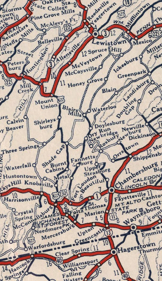
...but the 1927 list showed US 522 all the way between Selinsgrove and Hancock (via Lewistown and Mt. Union). "US 622" was not listed, as it would have been entirely redundant with US 522. However, "US 622" had already been published on some early maps (such as the one above). That same map also showed another US route that never actually existed:
|
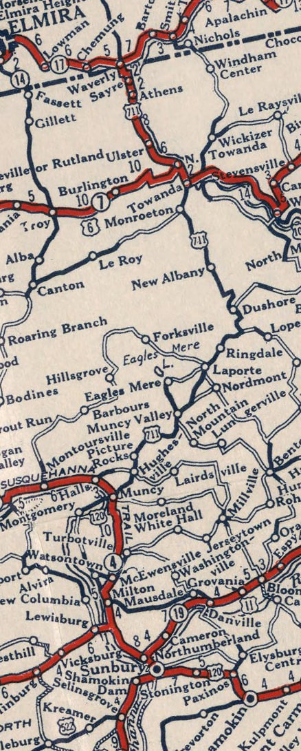
US 111, US 220, and "US 711": the 1926 map showed US 111 only between Harrisburg and Baltimore. US 220 was shown heading north from Williamsport (along what became US 111, and later US 15), ending at Lawrenceville. A "US 711" was shown along what became US 220, from the NY state line at Waverly to Muncy...
|
...but the 1927 list had US 220 following its current route east from Williamsport up to Waverly (replacing the entirety of "US 711"). US 111 had been extended north from Harrisburg up to Lawrenceville.
- US 611: it should be noted that US 611 was shown on the 1926 map, but not on the 1927 list. I suspect this route was inadvertently omitted from the 1927 list.
All of the discrepancies listed above involved Pennsylvania, which did not signpost its US routes at all until 1928. There were just a few additional differences in other states.
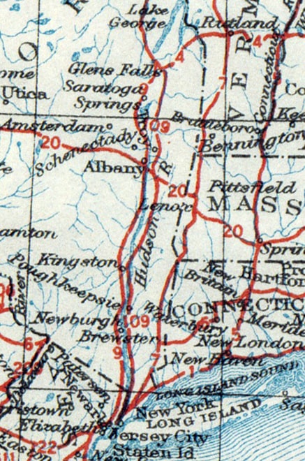
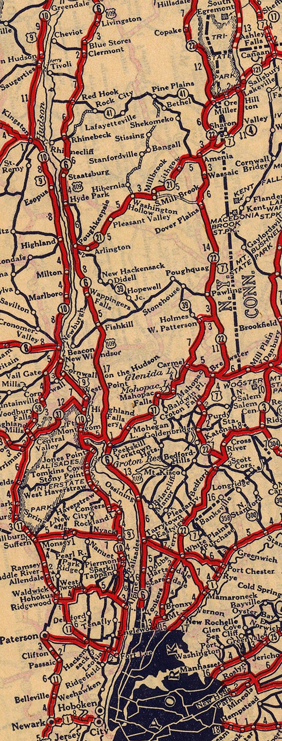
New YorkThe image below is a clip from the 1926 AASHO map, showing two discrepancies involving New York. Note there was a "US 109" along the east bank of the Hudson River; and instead of going through western Connecticut, US 7 was shown going into New York City:
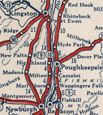
Both of those anomalies were also shown on some early commercial maps, even though probably no US 109 shield ever saw the light of day, and US 7 was probably never actually signed anywhere in New York state. As an example, this next map showed both US 109 and US 7 in NY.
|
|
...but the 1927 list indicated that Norwalk CT was the south terminus of US 7 (not NYC).
|
Idaho/Oregon
|
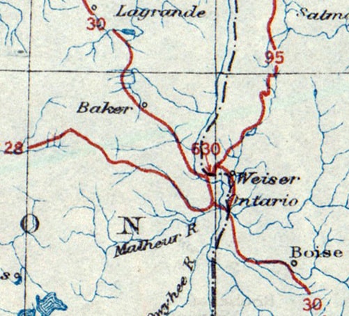
That leaves only one more US route that differed between the two sources, and this one was in the west. The 1926 map showed a "US 630" connecting with US 95 in Weiser ID and running across the Snake River to its junction with US 30:
|
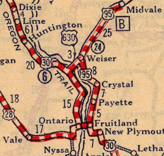
"US 630" was also shown on some early commercial maps - some even as late as 1932. This one shows the arrangement in more detail:
|
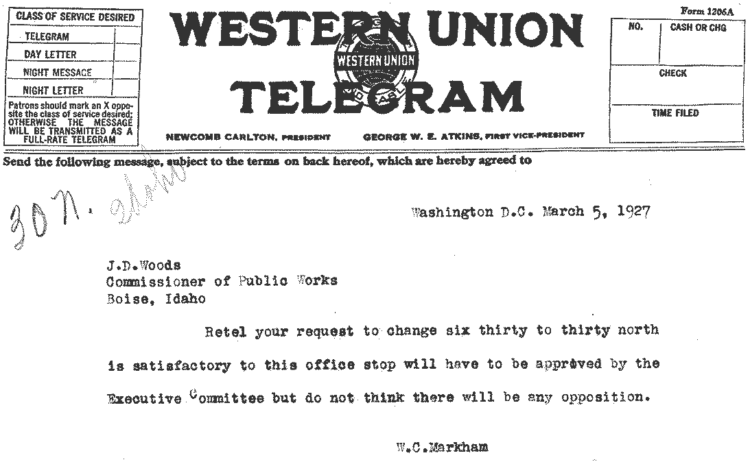
US 95 was shown heading south to Weiser, then continuing along the east bank of the Snake River, ending in Fruitland at its junction with US 30. US 30 crossed from Fruitland to Ontario, then continued north along the west bank of the Snake. At Weiser Junction OR, one could use "US 630" to cross the river into Weiser ID. This route was only three miles in length, meaning US 630 would have been the shortest-ever mainline US highway. But it is almost certain that the designation did not last long enough to ever be signposted. Already by February 1927, the Idaho state legislature had passed a resolution to adopt the US 30N designation, which made the US 630 designation superfluous. The Idaho Commissioner of Public Works forwarded this memorial to AASHO, which responded in early March via the telegram reproduced below:
I have not seen any similar correspondence from Oregon, but it is certain the two states were in agreement, or else AASHO would not have authorized the change. Already by the time of the April 1927 list, US 630 was no longer shown, US 95 was said to end in Weiser, and a new US 30N designation had been added. US 30N went north from Fruitland to Weiser, along what was originally planned as US 95. From there, US 30N crossed over into Oregon via what had been planned as US 630, and ended where it re-connected with US 30. By September 1927, Idaho reported to AASHO that it had signposted only 60% of its US routes, so it is extremely doubtful that US 630 would have been included among those that had actually been signed in the field by early 1927.
Signposting
A few other routes were included on both the 1926 map and the 1927 list, but were nonetheless never posted in the field. We know this because some states did not signpost their US routes immediately. As mentioned previously, Pennsylvania was one such state. Now we will turn our attention to another: Tennessee. Following is an excerpt from a Feb. 1929 letter from Tennessee to AASHO, stating at that time none of its US routes had been signed:
The routes "in question" included US 241, US 270, and US 511. AASHO had assigned those numbers based on the fact each of those relatively short routes functioned as an alternate to US 41, US 70, and US 11, respectively. But as of early 1929 Tennessee had still not signposted its US route numbers, in large part because they wanted the alternate routes to be designated instead as equal split routes (i.e. US 41E and US 41W; US 70N and US 70S; US 11E and US 11W). AASHO finally acquiesced to Tennessee's preferences, and accordingly Tennessee began signposting its US routes later in 1929. But the result is that three of Tennessee's US routes -- which appeared not only on AASHO's 1926 map, but also on several other early maps -- were never actually signed. One such example is this 1928 commercial map from Gallup, which showed all three: US 241 (upper left), US 270 (lower center), and US 511 (at right):
Research and/or photo credits: Nathan Edgars; Mike Roberson; Dale Sanderson
Page originally created 2019;
last updated Oct. 6, 2023.
last updated Oct. 6, 2023.


