Historic US highway endpoints in Grand Junction, CO
|
1927-1975
|
 |
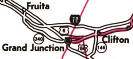
When the US routes were originally commissioned in 1926, US 24 went only as far west as Kansas City. West from Manhattan KS, US 40 was split into two routes: today's US 40 was signed as "US 40-S", and modern US 24 was known as "US 40-N". The two routes joined again in Limon CO. West of there US 40 followed essentially the same route as today. But US 40-S also continued west of Limon, following the path of today's US 24 through Colorado Springs and Minturn CO. From there, US 40S followed what would later become US 6 (better known today as I-70) to Grand Junction, where the designation ended at its junction with US 50. In other words, the west segment of US 40-S did not reconnect with mainline US 40.
In 1936, the US 24 designation was extended west from Kansas City, replacing US 40-N from Manhattan to Limon, and replacing US 40-S from Limon to Grand Junction (US 40-S from Manhattan to Limon became part of mainline US 40). The next year, US 6 was extended through the Rockies and all the way to California. Originally it met US 24 at Leadville CO and overlapped with it to Grand Junction. A few years later, after Vail Pass was built, US 6 did not meet US 24 until Minturn. This US 6-24 multiplex between Minturn and Grand Junction lasted for nearly 40 years, until 1975, when the US 24 designation was truncated to its present terminus at Minturn (where it junctions US 6). So today no US routes end in Grand Junction.
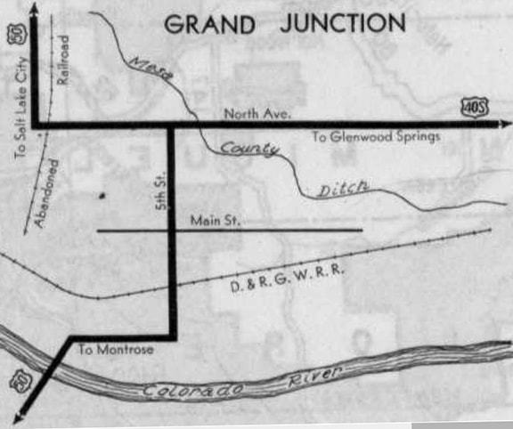
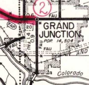
It is logical to assume US 40-S (and later US 6-24) would have followed the railroad all the way into downtown Grand Junction: dropping south to Pitkin Avenue before angling northward again. In other words, one would think the original highways followed today's Business Loop 70. However, in this particular case that would be an incorrect assumption. CDoT maps as early as 1931 indicate that US 40-S was actually routed across town on North Avenue (just as US 6 still uses North Av today). US 50 was shown heading north of Pitkin on 5th Street, then turning west on North Av. So US 40-S (and later US 24) ended on North Av at 5th:
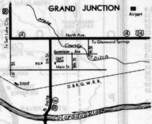
In 1936, the US 24 designation was extended west from Kansas City, replacing US 40-N from Manhattan to Limon, and replacing US 40-S from Limon to Grand Junction (US 40-S from Manhattan to Limon became part of mainline US 40). The next year, US 6 was extended through the Rockies and all the way to California. Originally it met US 24 at Leadville CO and overlapped with it to Grand Junction. A few years later, after Vail Pass was built, US 6 did not meet US 24 until Minturn. This US 6-24 multiplex between Minturn and Grand Junction lasted for nearly 40 years, until 1975, when the US 24 designation was truncated to its present terminus at Minturn (where it junctions US 6). So today no US routes end in Grand Junction.
It is logical to assume US 40-S (and later US 6-24) would have followed the railroad all the way into downtown Grand Junction: dropping south to Pitkin Avenue before angling northward again. In other words, one would think the original highways followed today's Business Loop 70. However, in this particular case that would be an incorrect assumption. CDoT maps as early as 1931 indicate that US 40-S was actually routed across town on North Avenue (just as US 6 still uses North Av today). US 50 was shown heading north of Pitkin on 5th Street, then turning west on North Av. So US 40-S (and later US 24) ended on North Av at 5th:
c. 1931, CDoT
|
c. 1937, CDoT
|
|
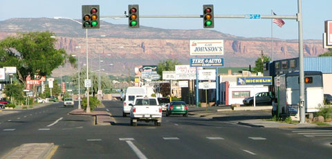
This photo was looking west on North Av at 5th, where today there is no interesting signage remaining, nor anything else that hints at this intersection's historical importance:
Sanderson, July 2004
|
That was the west terminus of US 40-S (and later US 24). Westbound US 50 took over straight ahead, while eastbound US 50 was to the left (south) on 5th. The cliffs in the distance are part of Colorado National Monument. Next we are looking north on 5th:
Sanderson, July 2004
|
|
That was westbound US 50, which continued to the left on North Av. To the right was the west beginning of US 40-S, and later the west beginning of US 24.
One more perspective: this shot was looking east on North Av (with a nice view of Grand Mesa in the background): |
Sanderson, May 2023
|
Historically that was eastbound US 50, which continued to the right on 5th; straight ahead was the west beginning of US 40-S and US 24.
|
US 24 continued to end on North Av. at 5th through at least 1955; that was the year CDoT petitioned AASHO to have US 24 extended west to St. George UT, and the map in their application illustrated that intersection as the east beginning of the proposed US 24 extension (which, incidentally, was never approved):
|
c. 1955, CDoT
|
|
Historic CDoT maps indicate that 1958 was the year of completion for the diagonal highway which heads northwest from downtown GJ, connecting the intersection of 1st and Grand to North Av (and forming a segment of today's US 50 and Business 70). Unlike many surface highways that pass through urban areas, this particular highway does not have a local road name; instead it is referred to simply as "US 6 and 50". The partial interchange at the junction with North Av. was shown on the USGS 1962 topo:
|
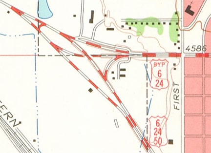
c. 1962, USGS
|
|
So around 1960 US 50 would have been rerouted off 5th and North Av, and instead along its current alignment through town. At that time, the US 24 designation was extended further west along North Av to its junction with the new US 50... but did you notice anything else interesting on that map? According to USGS (both the 1962 and 1973 editions), mainline US 6-24 was changed to follow today's Business 70 through downtown, while the original routing along North Av. was changed to Bypass 6-24. This next map shows the other end of that split, out towards Clifton and Fruitvale:
|
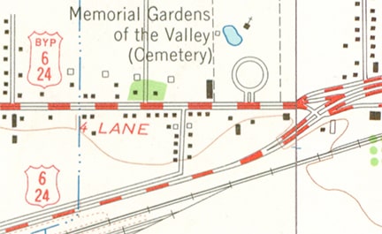
c. 1962, USGS
|
|
I have not found any evidence that CDoT ever petitioned AASHO to approve the Bypass 6-24 designation, nor the rerouting of mainline US 6-24. But in 1975, when CDoT sought AASHTO's permission to delete the US 24 designation between GJ and Minturn, the map in their application confirmed the fact that US 24 did indeed split into two forks at its western terminus:
|
c. 1975, CDoT
|
|
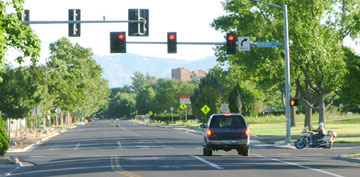
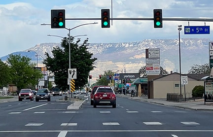
Today, heading southeast on US 6-50, the designations diverge, with US 6 traffic directed to head due east on North Av...
|
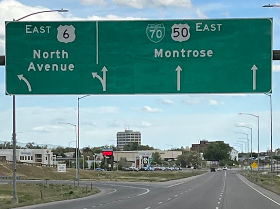
Sanderson, May 2023
|
...but during the 1960s and '70s the US 24 designation was also marked there. Straight ahead was US 50, mainline US 6, and the west beginning of mainline US 24. To the left on North Av. was the west beginning of Bypass 6-24.
|
|
Heading the opposite direction (northwest on US 50/Business 70), this was the west end of mainline US 24:
|
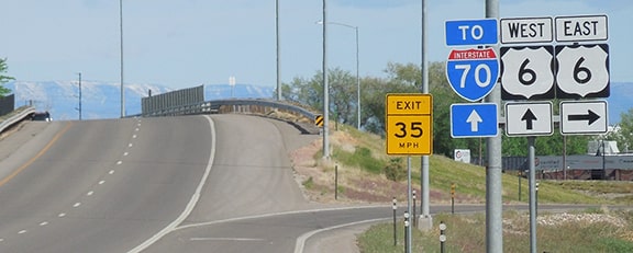
Sanderson, May 2023
|
To the right on North Av. was the west beginning of Bypass 6, which was also marked as Bypass 24.
|
|
These photos were looking west on North Av where it merges with the diagonal highway, heading northwest with US 50 and Business 70. This was the west end of US 24 Bypass until 1975, when US 24 was truncated to Minturn.
|
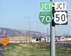
Sanderson, July 2004
|
Sanderson, May 2023
|
Research and/or photo credits: Matt Salek; Dale Sanderson
Page originally created 2004;
last updated May 8, 2023.
last updated May 8, 2023.
