US Ends .com
  • Home
  • Store
    • US highway map
    • Florida US highway map
  • Endpoints
    • US 1 - US 9 >
      • 1 >
        • 201
        • 301
        • 401 [i]
        • 401 [ii]
        • 401
        • 501
        • 601
        • 701
      • 2w >
        • 102
      • 2e >
        • 202
        • 302
      • 3
      • 4 >
        • 104
      • 5
      • 6 >
        • 106
        • 206
      • 7
      • 8
      • 9 >
        • 109*
        • 209
        • 309
    • US 10 - US 19 >
      • 10 >
        • 110
        • 210
        • 310
        • 410
      • 11 >
        • 111
        • 211
        • 311
        • 411 [i]
        • 411 [ii]
        • 411
        • 511*
        • 611
        • 711*
      • 12 >
        • 112
        • 212
        • 312
      • 13 >
        • 113
        • 213
      • 14
      • 15
      • 16 >
        • 116
        • 216
      • 17 >
        • 17-1
        • 117 [i]
        • 117
        • 217
      • 18 >
        • 118
        • 218
      • 19 >
        • 119
        • 219
        • 319
    • US 20 - US 29 >
      • 20e >
        • 120
        • 220
        • 320
        • 420
      • 20w
      • 21 >
        • 121 [i]
        • 121
        • 221
        • 321
        • 421
        • 521
      • 22 >
        • 122 [i]
        • 122 [ii]
        • 222
        • 322
        • 422e
        • 422w
        • 522
        • 622*
      • 23 >
        • 123 [i]
        • 123
        • 223
      • 24 >
        • 124
        • 224
      • 25
      • 26 >
        • 126
      • 27 >
        • 127
        • 227
      • 28
      • 29 >
        • 129
    • US 30 - US 39 >
      • 30 >
        • 130
        • 230
        • 330
        • 430
        • 530
        • 630*
        • 730
        • 830
      • 31 >
        • 131
        • 231
        • 331 [i]
        • 331
        • 431
      • 32
      • 33
      • 34
      • 35
      • 36 >
        • 136
      • 38 >
        • 138
    • US 40 - US 49 >
      • 40 >
        • 140
        • 240
        • 340
      • 41 >
        • 141
        • 241 [i]
        • 241 [ii]
        • 341
        • 441 >
          • 441n
          • 441s
        • 541
        • 641
      • 42
      • 43
      • 44
      • 45
      • 46
      • 48 [i]
      • 48 [ii]
      • 48
      • 49
    • US 50 - US 59 >
      • 50 >
        • 150
        • 250
        • 350
        • 450
        • 550
        • 650
      • 51 - 55 >
        • 51 >
          • 151
        • 52 >
          • 152
        • 53
        • 54 >
          • 154
        • 55
      • 56 >
        • 156
      • 57
      • 58 >
        • 158
        • 258
      • 59 >
        • 159
        • 259
    • US 60 - US 69 >
      • 60 >
        • 160
        • 260
        • 360
        • 460
      • 61 - 65 >
        • 61 >
          • 161
        • 62
        • 63 >
          • 163 [i]
        • 64 >
          • 164 [i]
          • 164 [ii]
          • 264
        • 65 >
          • 165
      • 66 >
        • 166
        • 266
        • 366 [i]
        • 366 [ii]
        • 466
        • 566
        • 666
      • 67 >
        • 167
      • 68 >
        • 168
      • 69 >
        • 169
    • US 70 - US 79 >
      • 70 >
        • 170
        • 270 [i]*
        • 270
        • 370
        • 470
      • 71 >
        • 171
        • 271
        • 371 [i]
        • 371
      • 72 - 76 >
        • 72
        • 73
        • 74
        • 75 >
          • 175
          • 275
        • 76 >
          • 176
          • 276
      • 77 >
        • 177
        • 277
        • 377
      • 78 >
        • 178
        • 278
        • 378
      • 79
    • US 80 - US 89 >
      • 80 - 84 >
        • 80 >
          • 180 [i]
          • 180
          • 280
          • 380
        • 81 >
          • 181
          • 281
        • 82
        • 83 >
          • 183
          • 283
          • 383
        • 84
      • 85 - 89 >
        • 85 >
          • 185
          • 285 [i]
          • 285
          • 385 [i]
          • 385
          • 485
        • 87 >
          • 187
          • 287n
          • 287s
        • 89n
        • 89s >
          • 189 [i]
          • 189
    • US 90 - US 99 >
      • 90 - 94 >
        • 90 >
          • 190
          • 290
        • 91 >
          • 191 >
            • 191n
            • 191s
          • 491
        • 92 >
          • 192
        • 93
        • 94
      • 95 -98 >
        • 95 >
          • 195
          • 295
          • 395
        • 96 [i]
        • 96
        • 97 >
          • 197
        • 98
      • 99 >
        • 199
        • 299
        • 399
    • Anomalies >
      • 101
      • 163
      • 400
      • 412
      • 425
  • Places
    • A-L >
      • A >
        • Aberdeen
        • Albuquerque
        • Amarillo
        • Apalachicola
        • Astoria
        • Atlantic
      • B >
        • Baltimore
        • Baton Rouge
        • Bay Area
        • Bishop
        • Boone
        • Brady
        • Bristol
        • Brownsville
        • Brunswick
      • C >
        • Charleston
        • Chattanooga
        • Chicago
        • Cincinnati
        • Cleveland
        • Cody
        • Corpus
        • Cortez
        • Council Bluffs
        • Covington
        • Crescent
        • Cumberland Gap
      • D-E >
        • Dallas
        • Des Moines
        • Detroit
        • Dothan
        • Douglas
        • El Paso
        • Eugene
        • Erie
      • F >
        • Farmington
        • Flagstaff
        • Florence
        • Fox Valley
        • Franklin
      • G >
        • Gallup
        • Grand Junction
        • Grand Portage
        • Grayling
        • Great Falls
        • Greeley
      • H-I >
        • Hardeeville
        • Harrisburg
        • Holbrook
        • Idaho Falls
        • Int'l Falls
      • J-K >
        • Jacksonville
        • Joplin
        • Junction
        • Kansas City
        • Keokuk
        • Key West
        • Kingman
      • L >
        • Laredo
        • Lewiston
        • Long Beach
        • Los Angeles
        • Louisville
        • Lubbock
    • M-R >
      • M >
        • Mackinaw
        • Madison
        • Maryhill
        • Maysville
        • Miami
        • Midway
        • Miles City
        • Milford
        • Milwaukee
        • Minneapolis
        • Mobile 31
        • Mobile 31-43-45
        • Montgomery
        • Monticello
        • Mount Vernon
      • N-O >
        • Nags Head
        • Naples
        • Natchez
        • New Castle
        • New Orleans
        • Niagara
        • Norlina
        • Ocean City
        • Oklahoma City
      • P >
        • Pee Dee
        • Pembina
        • Pensacola
        • Petersburg
        • Philadelphia
        • Piegan
        • Pineville
        • Port Arthur
        • Portsmouth
      • Q-R >
        • Quad Cities
        • Rapid City
        • Raton
        • Reading
        • Richmond
        • Rockingham
        • Rouses Point
    • S-Z >
      • S >
        • San Antonio
        • San Antonio NM
        • San Diego
        • Santa Fe
        • Savannah
        • Sioux
        • Springer
        • Springfield
        • St. Ignace
        • St. John
        • St. Paul
        • St. Pete
      • T-U-V >
        • Tallahassee
        • Tampa
        • Toledo
        • Trinidad
        • Ucolo
        • VA Beach
      • W >
        • Walterboro
        • Waverly
        • West Memphis
        • Wilmington
        • Wilson
        • Wrightsville
      • Y >
        • Yellowstone E
        • Yellowstone N
        • Yellowstone NE
        • Yellowstone S
        • Yellowstone W
  • Highways
    • Map of all endpoints
    • Sources
    • History
    • 1926 almost-routes
    • Intra-state routes
    • Numbering
    • Colors
    • Gaps
    • Blog
  • Bonus
    • Colorado >
      • Lowest point
      • Antipodes
      • Toponymy >
        • Roots
      • Colloquialisms
      • Populations
      • Denvers
    • Washington Meridian
    • Watersheds >
      • Headwaters Hill
      • Three Waters Mtn.
      • Parting of the Waters
    • Geo-centers >
      • 48 states
      • 50 states
      • North America
    • State corners >
      • AZ-CO-NM-UT
      • CO-UT-WY
      • CO-NE-WY
      • CO northeast
      • CO-KS-NE
      • CO-KS-OK
      • CO-NM-OK
      • NM-OK-TX
      • NM southeast
      • TX northwest
    • ooss.space
  • Connect
    • Author/history
    • Rationale
    • Contact
    • Contributors
    • Submissions

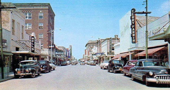
^photo above pre-1969, Johnson (source)

Current and historic US highway endpoints in Brownsville, TX

1927-present
Get your very own map showing all current and historic US routes!

This page was originally published in 2000, after several photos from Brownsville were submitted.  At that time, highway signage in the city was quite a mess.  This page pointed out all of the errors, and provided specific details about how each assembly should be changed.  At some point prior to 2008, nearly every erroneous sign in town was replaced to match exactly what was suggested on this page.  

​This animation gives an overview of how the highway configuration in Brownsville has changed over the years:
Picture

We will now discuss each of those steps in more detail.  In 1927, only one US route served Brownsville, and it no longer exists.  US 96 [i] was originally signed along what is now US 281 from Alice to Pharr, and from there along today's Business US 83 through Harlingen to Brownsville.  (The direct road between Kingsville and Harlingen -- today's US 77/I-69E -- did not exist at the time.)
Picture
c. 1927, Rand McNally
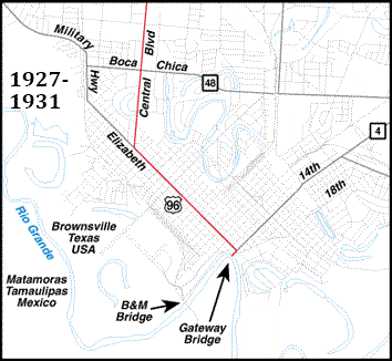
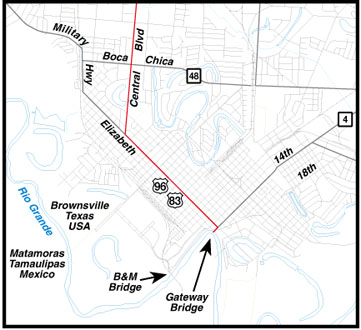
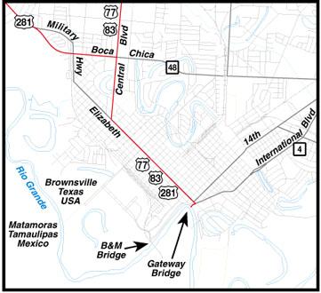
Concerning the exact routing of US 96 through Brownsville: the original bridge to Matamoros Mexico was built in 1909; it is known today as the B&M Bridge or Puente Viego ("old bridge").  Obviously it was there when US 96 was commissioned, so it is possible that the US 96 designation could have been routed to this bridge.  However, it is also possible that the B&M Bridge never served as a US route, because the second bridge (known as the Gateway Bridge or Puente Nuevo) was built in 1927.  This early Brownsville highway map does show the Gateway Bridge as the southern terminus of US routes serving the city, so presumably highways in Brownsville have always been routed onto Gateway rather than B&M:
Picture
c. 1940, TXDoT
As US 83-281 was shown to do on the map above, US 96 probably also used Central Boulevard, Elizabeth Street (which ran both ways then), and a short segment of 14th Street, ending at the Gateway Bridge:
Picture
1927-1931
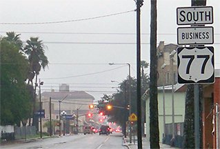
These photos were looking southeast on Elizabeth; these were the last shields posted along the route.  This was once US 96, and later US 83, 281, and 77.  Now it is officially Business US 77:
Picture
Taylor, 2000
Picture
Karners, Dec. 2014
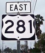
Note the odd-shaped shield on the 281 sign: that probably hailed from a time long ago.  Apparently when the route was truncated, the local DoT left the signs up, and in the intervening years they may have been replaced in-kind.  But as of 2008, it appears all references to Business 83-281 were finally removed; Elizabeth is now signed only as Business 77.  ​Several blocks ahead from there is International Boulevard...
Picture
Karners, Dec. 2014
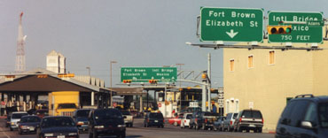
...but just before International, traffic originally was directed to the right on 14th, and historically there was a cool sign pointing Mexico-bound traffic in that direction:
Picture
c. 1970s, attribution unknown
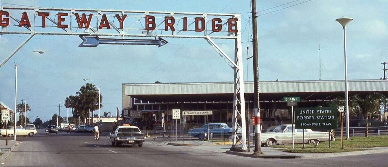
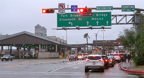
To the right on 14th was the original bridge approach.  Historically, if one were to turn that direction, they would have a view of the scene shown at the very top of this page (the original Gateway Bridge was replaced in 1969).  Here is a modern view looking south on 14th from Elizabeth:
Picture
Karners, Dec. 2014
14th has long since been closed to auto traffic, but even today it is plain to see how it formerly aligned with the Gateway Bridge in the background.  That border crossing originally marked the south end of US 96.  And in later years Gateway Bridge was the south end of US 83, US 281, and US 77.  This photo was taken looking the opposite direction:
Picture
Karners, Dec. 2014
​The segment of 14th to the north of Elizabeth is also vacated.  US 96 (and soon US 83 and US 281) began by turning left here onto Elizabeth.  Here are a couple views looking that direction: 
Picture
Haney, c. 1948
Picture
Taylor, 2000
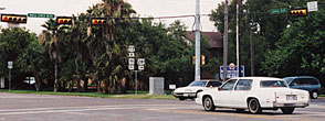
That first photo confirms that Elizabeth has been one-way southeastbound for several decades now, but historically it carried both directions of traffic.  Its northwestbound counterpart is Washington Street, one block to the north (right).  ​Formerly the first trailblazer was posted at 4th Street, which is a half-mile from International:
Picture
Taylor, 2000
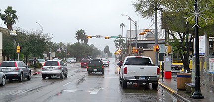
That assembly has since been removed; Washington is now signed as "Business 77" only.  The building in the distance is on Palm Blvd, which is the city's "zero" street.  Washington is discontinuous at that point, so traffic is routed over to Elizabeth (one block to the left), where that street begins to serve both directions.  

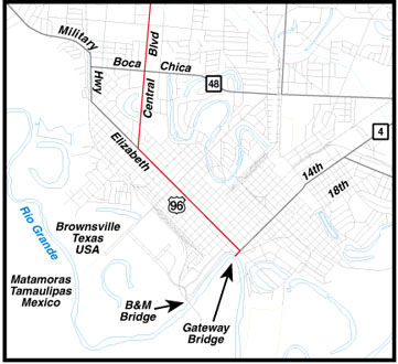
​In 1931, the US 83 designation was extended into Texas, essentially along its modern route.  US 83 came into Pharr from McAllen (as it does today), and at the time it overlapped with US 96 from there to Brownsville:
Picture
1931-1934
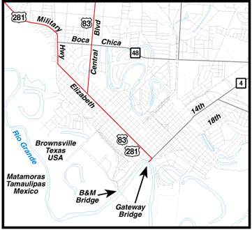
The two highways continued to follow the same route through town, ending at the Gateway Bridge.  US 96 was already done serving Brownsville by 1934 (it was completely decommissioned by 1939).  The original route of US 96 between Alice and Pharr became part of a newly-commissioned southern segment of US 281.  However -- instead of being overlapped with US 83 west from Pharr to Harlingen and Brownsville, as US 96 had been -- US 281 went south from Pharr (as it does today) to the Rio Grande.  Where the highway began to follow the river eastward, "North/South" signage ended and "East/West" signage began (more info on the US 281 page).  In Brownsville, US 281 was routed down the Military Highway (a different alignment than modern 281), which curved to become Elizabeth.  It met US 83 at Central Blvd, and the two routes were likely co-signed down Elizabeth to a common terminus on 14th at the Gateway Bridge:
Picture
1934-1945
It should be noted that the early TXDoT map indicates that the US 83 designation ended at Central and Elizabeth, and that it was only US 281 that continued to Gateway.  However, that seems unlikely, since US 83 had been signed all the way to the border before the US 281 designation was extended into Brownsville.  

​In 1945 the direct highway between Kingsville and Harlingen was built, and the US 77 designation was extended southward onto this road.  As it does today, US 77 met US 83 in Harlingen, and overlapped with it down to Brownsville.  In the city, the routes continued to use Central and Elizabeth:
Picture
1945-1950s
Note also a few other changes that probably took place somewhere around this time period: 18th Street was used as a segment of the new International Blvd, which was built to serve as a bypass for 14th.  The Gateway Bridge approach was modified to connect with International, and 14th no longer provided direct access to the bridge.  These photos were looking southwest on today's International Boulevard at the Gateway Bridge to Mexico:
Picture
Taylor, 2000 (same as of 2008)
Picture
Karners, Dec. 2014
Elizabeth is the next block, so that was the perspective of a driver at the south end of US 77-83.  That was also the perspective of someone at the "east" end of US 281... or at least the "signed" end of US 281.  At some point Boca Chica Boulevard was extended west (across Military Hwy and the railroad) and it became the new alignment for US 281.  When this happened, the US 281 designation was apparently truncated to the intersection with Central.  Or more accurately: while TXDoT may have officially truncated the route on paper, it appears the district DoT office never got around to taking down the signs.  It is possible that many of the US 281 signs that were still posted in the early 2000s were supposed to have been removed fifty years prior to that, but instead they had simply been replaced in-kind.
Here, the white car was heading south on Central Blvd; that was originally US 96, and later US 83 and US 77.  Today it is officially Business US 77.  The cross street is Boca Chica.  In the 1940s or '50s, when US 281 was realigned onto Boca Chica, its "east" terminus was truncated such that it began to the right:
Picture
Taylor, 2001
Picture
(detail)
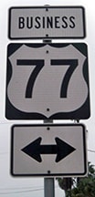
Note the word "BUSINESS" on the US 77 shield.  Ahead on Business 77 many signs for US 83, Business 83, US 281, and Business 281 were posted formerly, but those were removed by 2008.  ​Here is more recent signage from southbound Central Blvd, and from northbound as well:
Picture
Karners, Dec. 2014
Picture
Karners, Dec. 2014
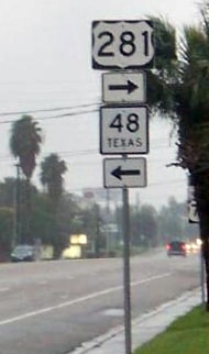
The photos below were taken looking west on Boca Chica at the Central Blvd intersection.  From this perspective, TX hwy. 48 ends; US 281 begins straight ahead; and Central is "Business US 77" both right and left.  But check out the signage that was once posted here:
Picture
Taylor, 2001
Picture
(detail)
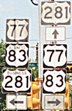
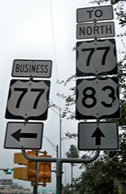
In 2001 this page commented that the top 281 sign was ok, and so was the left US 77 sign (assuming it said "Business").  "Business 83" was questionable, and "Business 281" was a complete fabrication.  To the right is certainly not mainline US 77-83; it should have said either "TO US 77-83" or else those shields should have said "Business" as well.  By 2008, that assembly had been replaced, and it matched our suggestions remarkably well:
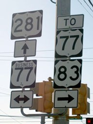
Picture
Straub, 2010
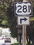
According to TXDoT info, since the 1940s or '50s, straight ahead has been the official east beginning of US 281.  This was the first westbound marker:
Picture
Taylor, 2001
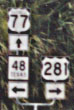
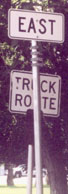
These next photos were taken from the opposite direction: east on Boca Chica, approaching Central.  This is the actual east end of US 281 since about 1948.  But instead of an "End US 281" assembly, drivers were told the route continues to the right on Central!  Looks like they recycled an older 281 shield.  And in the shadows behind this sign, there were a couple more cryptic signs:
Picture
Taylor, 2001
Picture
Taylor, 2001
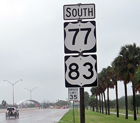
That could have been a US 281 shield under the "East" sign, perhaps with a right turn arrow below that (similar to the first photo).  But then, why would there have been two of the same assemblies?  Seems more likely that would have been a TX 48 marker (which was on this segment of Boca Chica before US 281).  And why they used three separate posts is beyond me.  Stephen commented, "Signage is haphazard in south Texas".  I had to laugh at the understatement... but to TXDoT's credit, this had all been cleaned up by 2008.  Here is the last eastbound marker, which was posted about three miles prior to the end of the route:
Picture
Karners, Dec. 2014
Picture
Karners, Dec. 2014
Also shown there is the corrected signage at the east end of US 281.

​Sometime during the 1950s the modern US 77-83 freeway was built between Harlingen and Brownsville.  At the time, the southern terminus of this freeway was at International Blvd.  The US 77-83 designations were routed onto this freeway, and then down International to the same old end at the Gateway Bridge.  A new Business Loop designation began where the freeway veers away from Central Blvd (off the north edge of this map), running from there along the original route (Central/Elizabeth), reconnecting with mainline 77-83 at International:
Picture
1950s-1999
According to TXDoT literature, the business loop is officially "Business US Highway 77".  According to TXDoT minute orders, there is no "Business US 83" here.  But that is where apparently there was a pretty radical departure from what the central DoT office decided and what the district DoT office actually did.  For one thing, it appears that -- instead of adding "BUSINESS" tabs above US 77 shields -- in many cases the district DoT made a non-standard decision to simply add the word "BUSINESS" directly onto the existing US 77 shields.  And worse: instead of taking down the US 83 and US 281 shields along Central and Elizabeth, they added the word "BUSINESS" to those signs as well.  So the map above reflects signage that was actually posted in the field, not the TXDoT official route designations.
The notion of "Business 83" worked fine, even if it was not official.  But the "Business 281" signs were a problem.  When US 77-83 was rerouted, the US 281 designation should have either been a.) extended east along Boca Chica to the new US 77-83, or b.) extended down Central and Elizabeth to the Gateway Bridge.  But apparently TXDoT did neither, nor did they check to see that the district office re-signed the routes correctly.

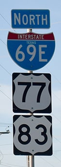
​In about 1999, the US 77-83 freeway was extended through International Blvd, to its modern border crossing: Veterans Memorial Bridge at Los Tomates:
Picture
1999-present
Again, that map reflected signage as of 2001, not official route descriptions (nor signage after 2008).  The routing problems were compounded, partly because Business US 77 has become a "Spur" instead of a "Loop".  Normally that would be acceptable, but it did not work well in this particular case, because the quickest way to get from Gateway to the US 77-83 freeway is not via Business 77, but rather via International (which is no longer a US route).  That resulted in double-take signage such as that shown here:
Picture
Taylor, 2000
That was looking northeast on International, just after entering the country from the Gateway Bridge.  It would have been a little less confusing if there was a "Business" modifier on the left assembly (which directs traffic up Washington), even though it was technically only Business 77 that direction.  The right assembly probably dated back to a time when International actually was mainline US 77-83, and the "TO" was added after the freeway was extended.  As of 2008, this particular assembly has been changed accordingly:
Picture
Karners, Dec. 2014
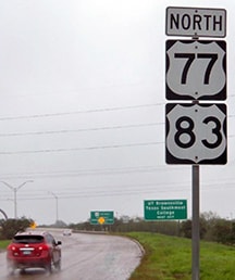
These photos were taken at the modern south terminus of US 77-83 at Veterans Bridge.  There was no "End" sign, but this is the last southbound US 77-83 sign.  The entrance for Brownsville's newest border crossing is visible in the background:
Picture
Taylor, 2000
Picture
Karners, Dec. 2014
These shots show the view at the south beginning of US 77-83, as one enters Texas from Mexico:
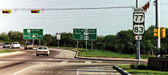
Picture
Taylor, 2000
Picture
Karners, Dec. 2014
Picture
Ivy/Nitzman, Aug. 2019
main US 77 page
main US 83 page
main US 96 page
main US 281 page
Research and/or photo credits: Jolene Haney; Brent Ivy; Baker Johnson; Karin and Martin Karner; Alex Nitzman; Dale Sanderson; Jason Straub; Stephen Taylor
Page originally created 2000;
last updated May 28, 2020.
Copyright © 1998-2023
Picture