Historic US highway endpoints in New Orleans, LA |
 |
It has not been a simple matter to determine where US routes historically ended in New Orleans. Several maps are shown below, but as you will see, most of them do not conclusively answer the question. This is because most do not differentiate US routes from other arterials, and/or because it is impossible to see where one designation ends when it is overlapped with another. What would be really helpful are historic photographs from the intersections in question, with posted highway shields visible.
|
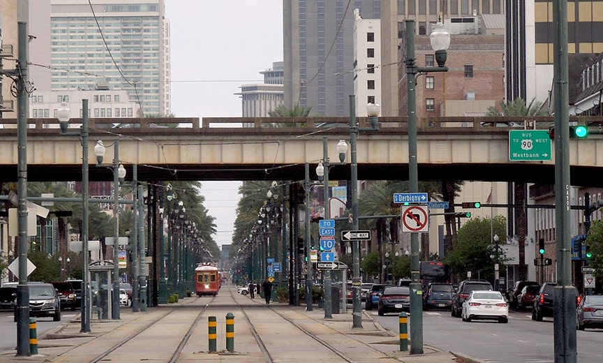
Reportedly US 90 originally crossed the Mississippi River via the Jackson Avenue/Gretna ferry, then continued up Jackson to rejoin its current routing at Claiborne Avenue. US 51 and US 61 came in together on today's US 90 (Claiborne), and ended at Jackson (the junction with old US 90). If so, then this photo (taken looking northeast on Claiborne) shows the original south end of US 51-61. Straight ahead was eastbound US 90, and westbound was to the right on Jackson:
|
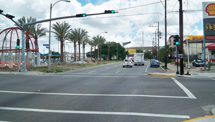
Karner, Jun. 2013
|
|
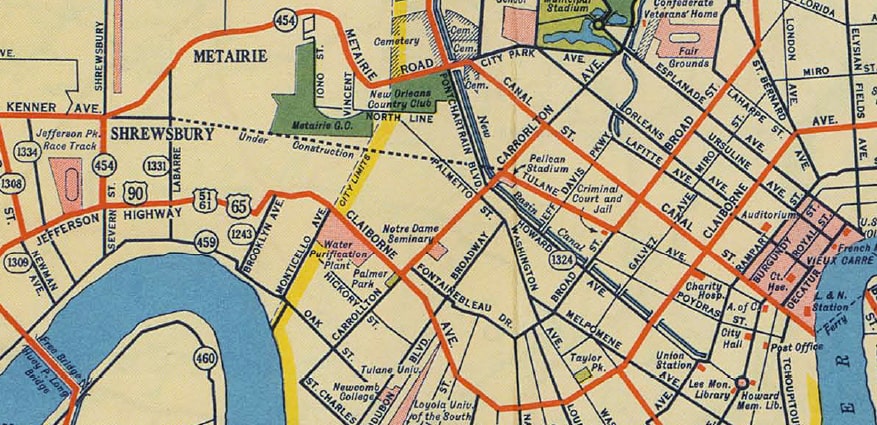
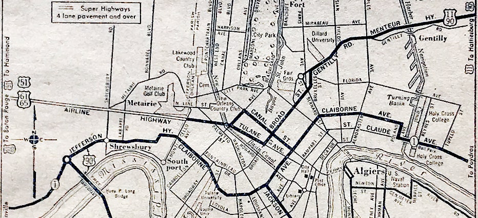
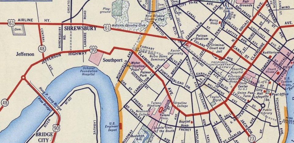
I have not seen anything that confirms or disproves that terminus, but if the following map was accurate, then already by 1928 US 90 was using the Walnut Street/Westwego ferry to get across the river. Beyond there, the map is not clear about what routing US 90 followed through the city, but regardless it seems likely that traffic would have somehow ended up at the intersection of Canal Street and Broad Street before continuing downriver to Gentilly Road. US 51-61 used Metairie Road, and then most likely Canal, so those designations could have ended at Broad (junction US 90). However, it was customary during the early years of the US route system to signpost routes to a point in the city center, so I would not be surprised if there was a US 51-61-90 overlap on Canal down to St. Charles Avenue:
|
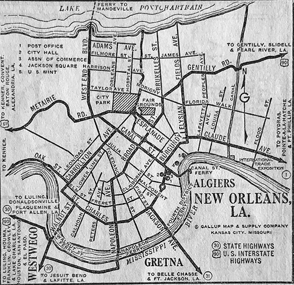
c. 1928, Gallup
|
|
This next map (1934) corroborates US 90's Westwego ferry crossing, and again suggests that US 51-61 ended either on Canal at Broad, Canal at Claiborne, or Canal at St. Charles:
|
c. 1934, Gallup
|
|
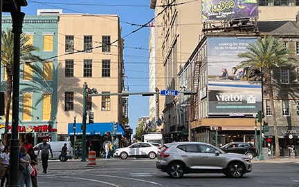
Photos from Canal/Broad can be seen below, but here is a photo looking downriver on St. Charles at Canal. It is possible that US 51-61 began to the left on Canal...
|
Sanderson, Mar. 2023
|
|
...or it is also possible that US 90 was already using Claiborne, in which case US 51-61 may have ended on Canal at Claiborne. That perspective is shown here:
|
Sanderson, Mar. 2023
|
The following year (1935), the Huey Long Bridge was opened to traffic, so that is when US 90 assumed its present routing. That same year the US 65 designation was extended into the New Orleans area (where it overlapped with US 51-61). Then in 1937, the US 11 designation was extended into the city as well (overlapped with US 90). All of those changes were shown on the following map (although the US 11 shield has been cropped out). Cartography was by Gousha, but this map was used for the 1939 official state publication for tourism:
c. 1939, Gousha
|
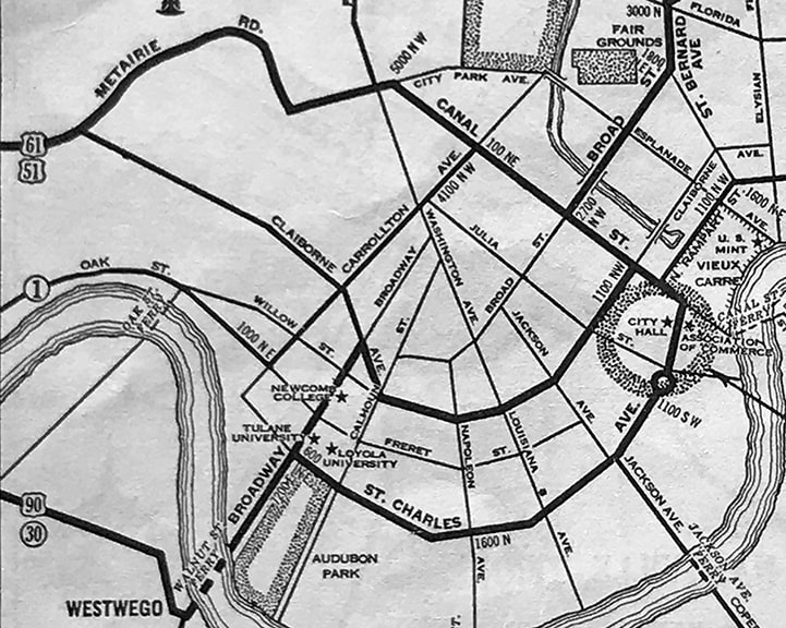
That map is not clear in terms of which red roads the US highways followed through the city, but it does show an interim routing for US 51-61-65, which joined US 90 while the Tulane Avenue - Airline Drive connection was under construction.
|
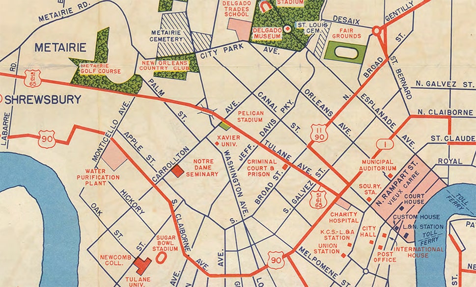
The USGS topo map from that same year (1939) shows something interesting: four US routes on Carrollton Avenue. US 51-61-65 were all shown to end at Canal, but US 90 continued riverbound on Canal to Broad, where it then resumed heading downriver while also picking up US 11:
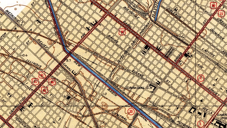
c. 1939, USGS
|
Route designations shown on USGS maps cannot always be considered reliable, although US 11 ending on Broad at Canal was probably accurate. The use of Carrollton as a temporary routing for US 51-61-65 does seem plausible, but it is perplexing why US 90 traffic wouldn't have simply remained on Claiborne. And indeed, this commercial map from the following year (1940) did show US 90 still on Claiborne:
|
c. 1940, Rand McNally
That map suggests that US 51-61-65 ended in Jefferson Parish, but we know from the maps above that those designations actually continued into the city with US 90. My understanding is later that same year (1940), the Airline - Tulane connection was completed. That alignment was shown on this 1947 map:
c. 1947, Rand McNally
However, the NOLA inset from the same year (1947) of LADoTD's official highway map is the earliest I have seen that is detailed enough to clearly illustrate the endpoints, and it showed a slightly different arrangement. It seems quite evident from this map that US 11, 51, 61, and 65 shared a common endpoint at Tulane and Claiborne. That was a short-lived situation though; the 1949 issue was the last to show it:
c. 1949, LADoTD
|
Here is a modern photo looking down Tulane at Claiborne (which has now been subsumed by an elevated portion of I-10). According to the map above, this intersection briefly served as the endpoint of US 51, 61, and 65:
|
Sanderson, Mar. 2023
|
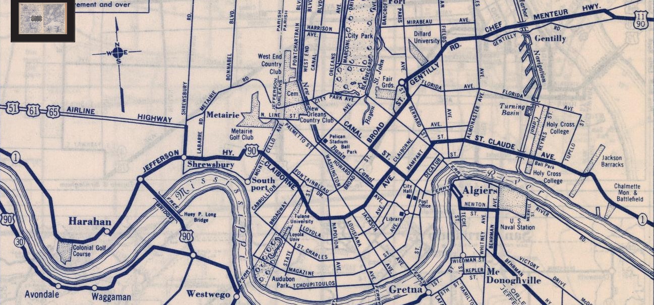
The following year, the 1950 map shown below was the first to plainly illustrate that the US 11, 51, 61, and 65 common terminus had been moved to the intersection of Broad and Canal:
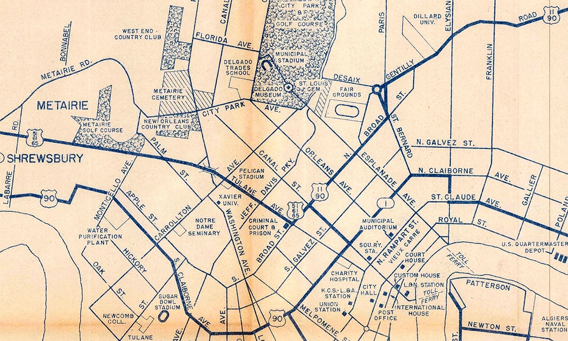
c. 1950, LADoTD
Two different 1950s editions of USGS topo maps continued to show the same arrangement as the 1939 topo (described previously). But it is highly doubtful those maps were correct, partly because I have not seen that arrangement corroborated on any other map, and additionally because in 1951 LADoTD removed several unnecessary highway overlaps, and as a result US 11, US 51, and US 65 were all truncated out of New Orleans. That left only US 61 and US 90, as shown on the LADoTD 1953 map, as well as this 1956 commercial map:
c. 1956, Gousha
|
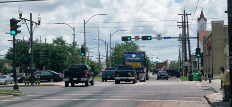
On that map (and also on contemporary LADOTD maps), we see a clear endpoint for US 61: it came in on Tulane, then turned onto Broad and ended at Canal, at a bend in US 90. This photo was taken looking downriver on Broad, where US 51-61-65 ended at US 90 (eastbound was straight ahead; westbound was to the right on Canal). Also straight ahead was the beginning of US 11:
|
Karner, Jun. 2013
|
|
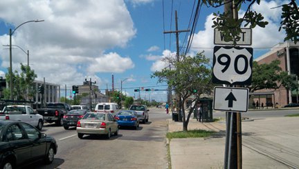
This next photo is looking the opposite direction (upriver on Broad), which was (and still is) westbound US 90. Until 1951 this was also US 11, which ended here. Today US 90 continues straight ahead, but until about 1957 it turned left on Canal, and straight ahead was the south beginning of US 51-61-65:
|
Karner, Jun. 2013
|
As we have seen on the maps above, originally US 90 traffic was directed to use Canal as the connection between Claiborne and Broad, but at some point things were changed such that Tulane was used as the connector (instead of Canal). Orleans Parish maps indicate that it was 1956-57 when this change was implemented, but LADoTD inset maps suggest it was more like the mid-1960s. Regardless, whenever the change took place, the four blocks straight ahead (which had been US 61) became US 90, so US 61 was truncated to its current terminus on Tulane at Broad. However, some maps were slow to catch up: it should be noted that several editions of USGS topos (from 1963-1989) showed US 61 ending on Tulane at Claiborne, with US 90 still using Canal. My only explanation is that was simply an error: all other contemporary maps show that highway traffic was originally routed along Canal, and then later along Tulane, but never both at the same time. Photos from the Broad/Tulane endpoint can be viewed on the main US 61 page.
Research and/or photo credits: Martin Karner; Dale Sanderson; "Urban Prairie Schooner"
Page originally created 2008;
last updated Apr. 4, 2023.
last updated Apr. 4, 2023.
