US Ends .com
  • Home
  • Store
    • US highway book
    • US highway map
    • Florida US highway map
  • Endpoints
    • US 1 - US 9 >
      • 1 >
        • 201
        • 301
        • 401 [i]
        • 401 [ii]
        • 401
        • 501
        • 601
        • 701
      • 2w >
        • 102
      • 2e >
        • 202
        • 302
      • 3
      • 4 >
        • 104
      • 5
      • 6 >
        • 106
        • 206
      • 7
      • 8
      • 9 >
        • 109*
        • 209
        • 309
    • US 10 - US 19 >
      • 10 >
        • 110
        • 210
        • 310
        • 410
      • 11 >
        • 111
        • 211
        • 311
        • 411 [i]
        • 411 [ii]
        • 411
        • 511*
        • 611
        • 711*
      • 12 >
        • 112
        • 212
        • 312
      • 13 >
        • 113
        • 213
      • 14
      • 15
      • 16 >
        • 116
        • 216
      • 17 >
        • 17-1
        • 117 [i]
        • 117
        • 217
      • 18 >
        • 118
        • 218
      • 19 >
        • 119
        • 219
        • 319
    • US 20 - US 29 >
      • 20e >
        • 120
        • 220
        • 320
        • 420
      • 20w
      • 21 >
        • 121 [i]
        • 121
        • 221
        • 321
        • 421
        • 521
      • 22 >
        • 122 [i]
        • 122 [ii]
        • 222
        • 322
        • 422e
        • 422w
        • 522
        • 622*
      • 23 >
        • 123 [i]
        • 123
        • 223
      • 24 >
        • 124
        • 224
      • 25
      • 26 >
        • 126
      • 27 >
        • 127
        • 227
      • 28
      • 29 >
        • 129
    • US 30 - US 39 >
      • 30 >
        • 130
        • 230
        • 330
        • 430
        • 530
        • 630*
        • 730
        • 830
      • 31 >
        • 131
        • 231
        • 331 [i]
        • 331
        • 431
      • 32
      • 33
      • 34
      • 35
      • 36 >
        • 136
      • 38 >
        • 138
    • US 40 - US 49 >
      • 40 >
        • 140
        • 240
        • 340
      • 41 >
        • 141
        • 241 [i]
        • 241 [ii]
        • 341
        • 441 >
          • 441n
          • 441s
        • 541
        • 641
      • 42
      • 43
      • 44
      • 45
      • 46
      • 48 [i]
      • 48 [ii]
      • 48
      • 49
    • US 50 - US 59 >
      • 50 >
        • 150
        • 250
        • 350
        • 450
        • 550
        • 650
      • 51 - 55 >
        • 51 >
          • 151
        • 52 >
          • 152
        • 53
        • 54 >
          • 154
        • 55
      • 56 >
        • 156
      • 57
      • 58 >
        • 158
        • 258
      • 59 >
        • 159
        • 259
    • US 60 - US 69 >
      • 60 >
        • 160
        • 260
        • 360
        • 460
      • 61 - 65 >
        • 61 >
          • 161
        • 62
        • 63 >
          • 163 [i]
        • 64 >
          • 164 [i]
          • 164 [ii]
          • 264
        • 65 >
          • 165
      • 66 >
        • 166
        • 266
        • 366 [i]
        • 366 [ii]
        • 466 [i]*
        • 466 [ii]
        • 566
        • 666
      • 67 >
        • 167
      • 68 >
        • 168
      • 69 >
        • 169
    • US 70 - US 79 >
      • 70 >
        • 170
        • 270 [i]*
        • 270
        • 370
        • 470
      • 71 >
        • 171
        • 271
        • 371 [i]
        • 371 [ii]
        • 371
      • 72 - 76 >
        • 72
        • 73
        • 74
        • 75 >
          • 175
          • 275
        • 76 >
          • 176
          • 276
      • 77 >
        • 177
        • 277
        • 377
      • 78 >
        • 178
        • 278
        • 378
      • 79
    • US 80 - US 89 >
      • 80 - 84 >
        • 80 >
          • 180 [i]
          • 180
          • 280
          • 380
        • 81 >
          • 181
          • 281
        • 82
        • 83 >
          • 183
          • 283
          • 383
        • 84
      • 85 - 89 >
        • 85 >
          • 185
          • 285 [i]
          • 285
          • 385 [i]
          • 385
          • 485
        • 87 >
          • 187
          • 287n
          • 287s
        • 89n
        • 89s >
          • 189 [i]
          • 189
    • US 90 - US 99 >
      • 90 - 94 >
        • 90 >
          • 190
          • 290
        • 91 >
          • 191 >
            • 191n
            • 191s
          • 491
        • 92 >
          • 192
        • 93
        • 94
      • 95 -98 >
        • 95 >
          • 195
          • 295
          • 395
        • 96 [i]
        • 96
        • 97 >
          • 197
        • 98
      • 99 >
        • 199
        • 299
        • 399
    • Anomalies >
      • 101
      • 163
      • 400
      • 412
      • 425
  • Places
    • A-L >
      • A >
        • Aberdeen
        • Albuquerque
        • Amarillo
        • Apalachicola
        • Astoria
        • Atlantic
      • B >
        • Baltimore
        • Baton Rouge
        • Bay Area
        • Bishop
        • Boone
        • Brady
        • Bristol
        • Brownsville
        • Brunswick
      • C >
        • Charleston
        • Chattanooga
        • Chicago
        • Cincinnati
        • Cleveland
        • Cody
        • Corpus
        • Cortez
        • Council Bluffs
        • Covington
        • Crescent
        • Cumberland Gap
      • D-E >
        • Dallas
        • Des Moines
        • Detroit
        • Dothan
        • Douglas
        • El Paso
        • Erie
        • Eugene
      • F >
        • Farmington
        • Flagstaff
        • Florence
        • Fox Valley
        • Franklin
      • G >
        • Gallup
        • Georgetown
        • Grand Junction
        • Grand Portage
        • Grayling
        • Great Falls
        • Greeley
      • H-I >
        • Hardeeville
        • Harrisburg
        • Holbrook
        • Idaho Falls
        • Int'l Falls
      • J-K >
        • Jacksonville
        • Joplin
        • Junction
        • Kansas City
        • Keokuk
        • Key West
        • Kingman
      • L >
        • Laredo
        • Lewiston
        • Long Beach
        • Los Angeles
        • Louisville
        • Lubbock
    • M-R >
      • M >
        • Mackinaw
        • Madison
        • Maryhill
        • Maysville
        • Miami
        • Midway
        • Miles City
        • Milford
        • Milwaukee
        • Minneapolis
        • Mobile 31
        • Mobile 31-43-45
        • Montgomery
        • Monticello
        • Mount Vernon
      • N-O >
        • Nags Head
        • Naples
        • Natchez
        • New Castle
        • New Orleans
        • Niagara
        • Norlina
        • Ocean City
        • Oklahoma City
      • P >
        • Pee Dee
        • Pembina
        • Pensacola
        • Petersburg
        • Philadelphia
        • Piegan
        • Pineville
        • Port Arthur
        • Portsmouth
      • Q-R >
        • Quad Cities
        • Rapid City
        • Raton
        • Reading
        • Richmond
        • Rockingham
        • Rouses Point
    • S-Z >
      • S >
        • San Antonio
        • San Antonio NM
        • San Diego
        • Santa Fe
        • Savannah
        • Sioux
        • Springer
        • Springfield
        • St. Ignace
        • St. John
        • St. Paul
        • St. Pete
      • T-U-V >
        • Tallahassee
        • Tampa
        • Toledo
        • Trinidad
        • Tuba City
        • Ucolo
        • VA Beach
      • W >
        • Walterboro
        • Waverly
        • West Memphis
        • Wilmington
        • Wilson
        • Wrightsville
      • Y >
        • Yellowstone E
        • Yellowstone N
        • Yellowstone NE
        • Yellowstone S
        • Yellowstone W
  • Highways
    • Map of all endpoints
    • Sources
    • History
    • 1926 almost-routes
    • Intra-state routes
    • Numbering
    • Colors
    • Gaps
    • Blog
  • Bonus
    • Colorado >
      • Lowest point
      • Antipodes
      • Toponymy >
        • Roots
      • Colloquialisms
      • Populations
      • Denvers
    • Washington Meridian
    • Watersheds >
      • Headwaters Hill
      • Three Waters Mtn.
      • Parting of the Waters
    • Geo-centers >
      • 48 states
      • 50 states
      • North America
    • State corners >
      • AZ-CO-NM-UT
      • CO-UT-WY
      • CO-NE-WY
      • CO northeast
      • CO-KS-NE
      • CO-KS-OK
      • CO-NM-OK
      • NM-OK-TX
      • NM southeast
      • TX northwest
  • Connect
    • Author/history
    • Rationale
    • Contact
    • Contributors
    • Submissions

End of historic US highway 240

View a map showing this route.
Get your very own map showing all current and historic US routes!
Picture
Summa
1926-1927
  • North: Harrisburg, PA
  • South: Washington, DC
1927-1972
  • North: Frederick, MD
  • South: Washington, DC
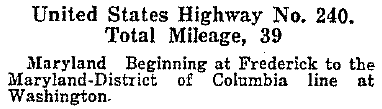
One alignment of US 240 measured 43.3 miles, and the other routings through DC did not significantly alter the total length.
Get your copy of this epic book that commemorates the first century of the US route system!

The US 240 designation had a sketchy early history in Pennsylvania.  The map that AASHO approved in 1926 showed US 240 not only from Washington DC to Frederick, but also from there up to Harrisburg.  That was because at the time US 15 was planned to go only as far north as Virginia.  However, already by the time of AASHO's April 1927 route log, US 15 was in Harrisburg.  Thus there was no need for US 240 to extend north of Frederick, so it was never signposted anywhere in Pennsylvania:
Picture
Picture
c. 1939, Rand McNally
The route served the Frederick-DC corridor until it was decommissioned in 1972.

​
This map of Frederick suggests that US 240 ended at its junction with US 15 south of town...
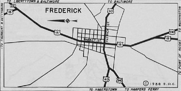
Picture
c. 1938, MD DoT
...however, it is more likely that US 240 would have been dual-signed with US 15, ending at its "parent" route (US 40).  This photo was taken looking north on Market Street; US 240 probably ended here at Patrick Street:
Picture
Brooks, Aug. 2019
That intersection is known as Frederick Square Corner; interpretive markers there attest to the historic importance of that crossroads. 

​This photo was taken looking west on Patrick, which today carries MD hwy. 144 traffic, but historically served as US 40
.  To the left on Market was the north beginning of US 240:
Picture
Mortell, Aug. 2007
I-70S (now I-270) was complete by 1959, and US 240 traffic was rerouted to follow this faster road.  At that time (according to a historic list of route numbering changes in Maryland), the designation was changed such that it ended at the same interchange where I-270 ends today.  This photo shows signage at the north end of I-270, and at what was the north end of US 240 until it was decommissioned in 1972:
Picture
aaroads.com, Aug. 2013

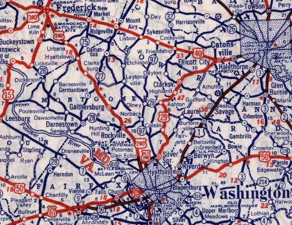
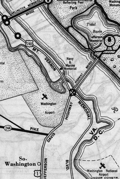
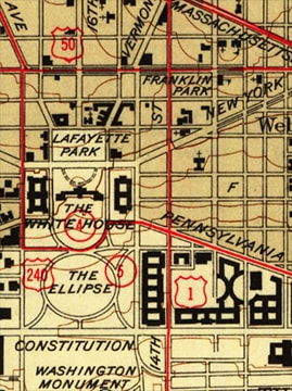
From Frederick, US 240 originally followed what is now MD 355 into the District, entering on Wisconsin Avenue, then turning onto Massachusetts Avenue.  But from there the D.C. routing changed over the years.  The earliest map I have seen with detail about US 240's route (1937) shows that the route actually crossed into Virginia before ending at US 1.  These slightly-later maps showed that same arrangement...
Picture
c. 1940, Rand McNally
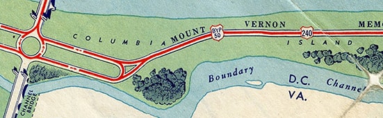
Picture
c. 1942, Esso
...but then there was a brief time during the mid-1940s when US 240 ended at the White House (or, more accurately, the Zero Milestone on the Ellipse south of the White House).  Apparently US 240 went south on 17th Street, then east on "E" Street to its terminus.  Even though this USGS map suggests it ended on Pennsylvania Avenue at jct. US 1 (14th Street)...
Picture
c. 1945, USGS

...the District's 1946 application to AASHO expressly noted the Zero Milestone as the terminus:
Picture
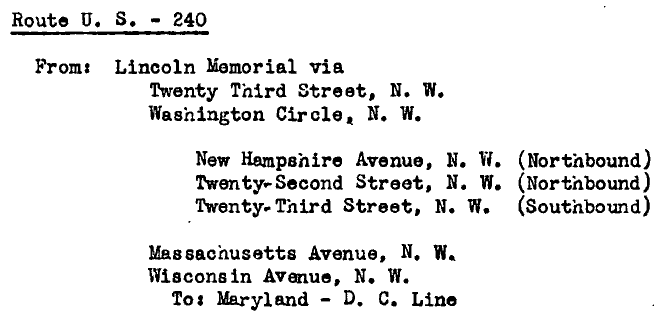
That also described US 240's new endpoint (17th at Independence Avenue), but there are reasons to doubt it was ever signposted that way.  For one thing, DC's 1946 application seems to have included two different maps showing proposed changes to US route alignments.  One illustrated US 240 ending as described above, but the other showed US 240 ending at the Lincoln Memorial.  And a few months after AASHO approved DC's proposed changes, they asked the District Dept. of Highways for a route log, and the one they received defined US 240's terminus as the Lincoln Memorial:
Picture
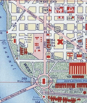
So most maps throughout the 1950s show US 240 back on its older alignment, but instead of crossing the Arlington Memorial Bridge, the route ended at its junction with US 50 at the Lincoln Memorial:
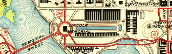
Picture
c. 1951, USGS
Picture
c. 1956, Gousha
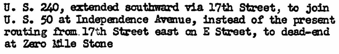
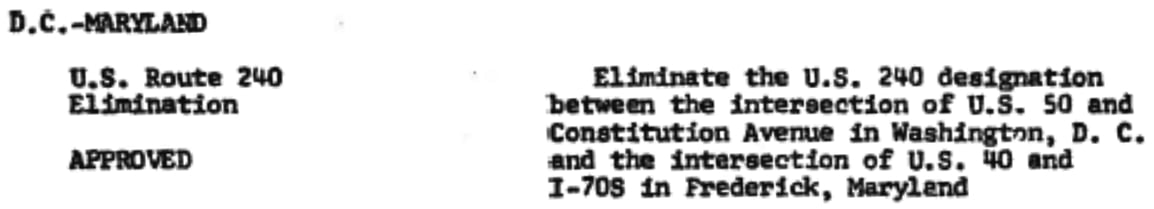
By the time of AASHO's 1969 route log, US 240 was back to using Connecticut and 17th; but this time the designation continued past "E", ending instead on 17th at Constitution Avenue, which had recently become the route of US 50 (that happened when the Theodore Roosevelt Bridge opened in about 1960, and US 50 traffic stopped using the Arlington Memorial Bridge).  That was its final routing at the time of its decommissioning in 1972; following is that agenda item from the minutes of AASHO's meeting in June of that year:
Picture
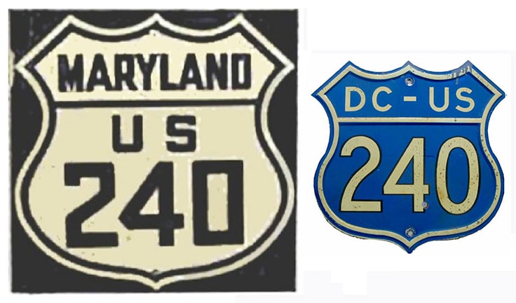
​In addition to all of these variations in its route, another interesting thing about US 240 is that, for a brief period, it was signposted with colored shields in DC (this photo was taken at the Lincoln Memorial, when US 240's terminus was there):
Picture
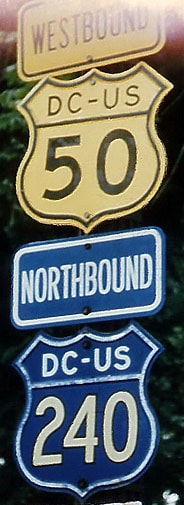
c. 1957, Lindsay (linked to source)

Research and/or photo credits: Robert Brooks; Jim Lindsay; Robert Mortell; Alex Nitzman; Mike Roberson; Dale Sanderson; Michael Summa
Page originally created 2005;
last updated Dec. 20, 2021.
Copyright © 1998-2025
Picture