Corner of Colorado-Utah-Wyoming
|
According to the Congressional definition of the boundary of Colorado, this point is theoretically where the 41st parallel north latitude intersects 32 degrees west longitude as measured from the Washington Meridian*. The south line of Wyoming was surveyed by A.V. Richards in 1873, but he was not tasked with locating this corner. This location was fixed and monumented by Rollin Reeves in 1879 when surveying the west line of Colorado. Due to the technological limitations of that age, it is not in exactly the right spot (although these surveys do define the official boundaries, regardless of their accuracy).
|
|
* Many American surveys between 1850-1884 were based on the Washington Meridian, which was officially abolished by Congress in favor of the Greenwich Prime Meridian in 1912. "32 degrees west of Washington" is a few miles away from the 109th degree of longitude west of Greenwich.
Note: The book "Colorado Mapology" (Erl H. Ellis, 1983, Jende-Hagan Book Corporation) is an excellent resource, from which I obtained much of the information presented on these pages. The black-and-white photos below were taken by him, and are published in that book.
Note: The book "Colorado Mapology" (Erl H. Ellis, 1983, Jende-Hagan Book Corporation) is an excellent resource, from which I obtained much of the information presented on these pages. The black-and-white photos below were taken by him, and are published in that book.
|
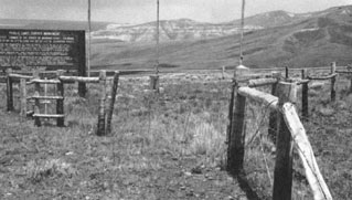
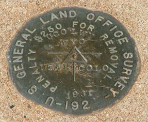
According to Reeves' field notes, he monumented this corner by placing a large red sandstone that had the names of the three states and the coordinates of the location chiseled into it. On top of this was a pile of rocks about five feet high. About 50 years later (in 1931), this monument was found disturbed, so it was replaced with a standard benchmark set in concrete. In 1966, a large wooden interpretive sign was erected adjacent to the tri-state marker. It is visible at far left in this photo:
|
|
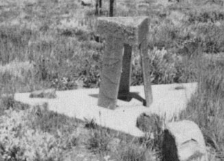
The fence in the foreground runs due north/south along the Utah/Colorado border, but just shy of the Wyoming line it splits into a triangle-shaped enclosure, which perhaps was built at the same time the sign was added. If one were to continue north along that fenceline, they would reach the actual tri-state corner, visible in the distance, and shown close-up here:
|
|
The bronze disk sits in the center of that concrete apron. I am not sure what to call that, um... that "tripod-umbrella thing" that sort of protected the disk (it is gone now, as shown in the photos that follow). The top of the large sign shown in the first photo is enlarged here:
|
|
When Mr. Ellis visited in 1969, he noticed the longitude given on this sign was incorrect: it should be 109 degrees (plus minutes and seconds). His correspondence with the BLM resulted in a correction to the sign in 1972. Here is an enlargement of the text that was at the bottom of the sign:
|
|
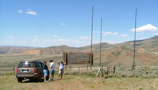
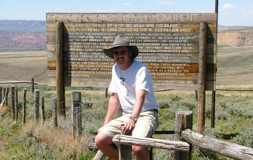
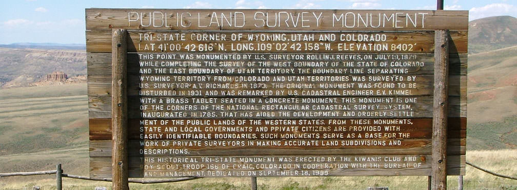
It is unclear whether those service clubs were the ones responsible for embedding some of the original stones in the concrete, or if they were simply pointing out the significance of the stones that were already there (perhaps since 1931). I tend to believe the former (more on that later). I have reproduced those parts of the sign because they were the only parts that differed from the text on the sign as it appeared in 2006 (shown in its entirety below). I am not sure what happened to the original sign. I assume it was damaged or destroyed, but at any rate it was replaced in 1999 with the sign that was still there at the time of my visit. Shown here is an overview of the site:
|
|
That was looking north. The camera was in Utah, but just off to the right is a fence that marks the Colorado border. The fence visible ahead is the Wyoming line, so everything in the background is in that state. On the far right is part of Pine Mountain, and to the left is all part of the Red Creek Basin. Presumably those three poles originally bore the flags of the three states that meet here -- but, although the poles were visible in Ellis' 1969 photos, he did not mention any flags in his text. The triangle-shaped enclosure was still there. Built into the fence was a metal turnstile intended to let people in but keep critters out. It made for an amusing merry-go-round...
|
...and it is usually windy enough that one does not even need a push from a friend. Here is a close-up of the sign:
|
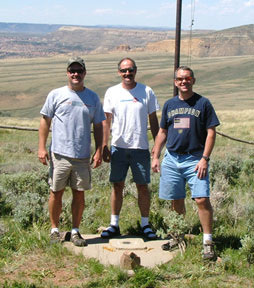
That was looking northwest: the camera was in Colorado, but the guy wearing gray was in Utah, and the guy in white was in Wyoming. So was the guy wearing blue, but if he took one step forward, he would cross into Colorado. At their feet is the brass tablet. It was set in a small, square concrete base, which was surrounded by a larger triangle base. Possibly the square base was the one set in 1931, and the triangle base was added in 1966 (the same time other improvements were made to this site). Just outside the square base are marks where two of the three "tripod" legs were once set in the concrete. The disk itself is shown close-up here:
|
Now for some info on how to find this tri-state corner. It is quite remote, and getting there is no trivial matter. The first time I tried, I got lost because I didn't have a detailed map along. The second time, I knew how to get there, but still couldn't, because I didn't have a four-wheel-drive. Third time was a charm...
|
The closest interstate access is from I-80's exit 99 in Wyoming. Heading south from Rock Springs on US 191, many maps indicate that one can take Sweetwater County Road 34* east for a few miles, and then CR 27** south to within a few miles of the tri-state corner...
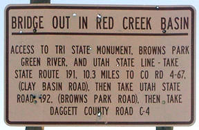
*Some maps label this "Ramsey Ranch Rd", while others refer to it as "Salt Wells Creek Rd". **Some maps label this "Aspen Mountain Rd", while others refer to it as simply "Aspen Rd". ...however, when I turned off US 191 onto CR 34, I was greeted with this sign: |
|
That was also there during my first attempt in 1999, so it does not appear that repairing the bridge is a high priority. The directions are helpful, but pay close attention to the "10.3 miles", because the road you want is not marked as "CR 4-67" or "Clay Basin Rd"... it is actually signed as CR 62:
|
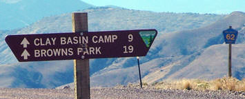
When you leave US 191 there, you won't see another paved road for a long time. CR 62 heads south, through a gap in the Tepee Mountains -- shortly beyond that, you cross into Utah. It's also a little confusing once you get to Clay Basin -- there are several roads around there, and it's unclear which is the "main" one that leads to Browns Park Rd.
|
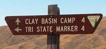
You're looking for a fairly well-traveled road that runs east-west, along the south side of the settlement. I don't believe it's marked as CR 192 (as the sign in the photo above indicates), or anything else for that matter, but all roads in the area connect to it eventually. Once you've reached it, go east for a couple miles, until you see this sign:
|
|
That turnoff is a road that essentially follows a small valley northward along the west side of Bender Mountain (this is the road which -- according to maps -- becomes CR 27 in Wyoming, but I'm not sure how far north you can actually go on it). About five miles into it, you cross a cattle guard and enter Wyoming. Not far beyond that, the road begins a fairly steep climb. When I was there, it was deeply rutted and badly eroded in spots -- this is where you'll begin to be glad you have a 4WD. After about a mile, the road crests a ridge, where the sign shown here was posted:
|
(That was actually for drivers heading southbound. There was no similar sign heading north -- perhaps it was removed because it referenced something ahead in Wyoming that you can no longer reach due to the bridge closure.) Anyway, the road east from there to the marker doesn't get any better. It was a bit foolhardy going even this far in my little Civic, and if something would've happened, it would've been a long hike back to find some help. I considered hiking the rest of the way to the monument, but I didn't have any way to carry water, nor was I prepared for three hours of sun exposure. So I reluctantly turned back...
...but fortunately I have some good buddies who own 4WDs and are always up for an adventure. We actually approached from the Colorado side: US 40 to Colorado 318. Where that highway crosses into Utah, it becomes the unpaved "Browns Park Rd", going up through Jesse Ewing Canyon towards Clay Basin. But the turnoff to the tri-state marker is just before you reach Clay Basin -- it's marked with a BLM sign similar to the ones shown above.
...but fortunately I have some good buddies who own 4WDs and are always up for an adventure. We actually approached from the Colorado side: US 40 to Colorado 318. Where that highway crosses into Utah, it becomes the unpaved "Browns Park Rd", going up through Jesse Ewing Canyon towards Clay Basin. But the turnoff to the tri-state marker is just before you reach Clay Basin -- it's marked with a BLM sign similar to the ones shown above.
Research and/or photo credits: Dale Sanderson
Page originally created 2003;
last updated Nov. 17, 2016.
last updated Nov. 17, 2016.
