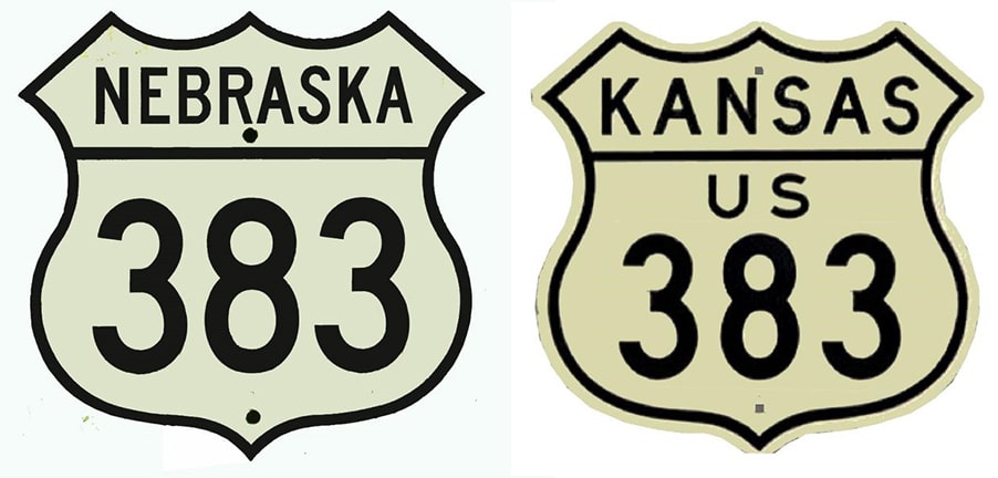
End of historic US highway 383 |
 |
Summa
|
|
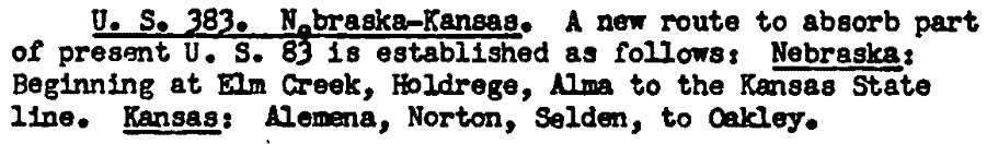
In 1941 some big changes were made to the routes of US 83 and 183 in SD, NE, and KS (that is all covered in detail on this blog post). As a result of those changes, a 73.9 mile segment of former US 83 needed a new designation. Back then AASHO was typically pretty meticulous about ensuring that former US route segments remained a part of the network; thus the new US 383 designation was born.
|
Here is that agenda item from the minutes of AASHO's 1941 meeting:
|
|
|
US 383 went from US 30 in Nebraska to US 40 in Kansas, for a total of 165.9 miles, but 92 of those miles were overlapped with other US routes.
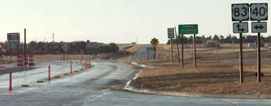
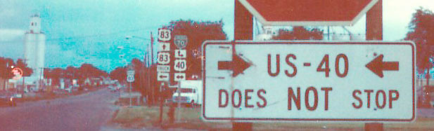
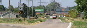
During its lifespan of nearly four decades, the south end of US 383 was in Oakley. Today US 83 traffic is directed onto US 40 for one mile, and it bypasses Oakley to the west. But when US 383 was around, highway traffic was routed right through town (383 was dual-signed with US 83): |
c. 1950, Gousha
|
|
These photos were taken looking south on Freeman Avenue (the former alignment of US 83-383) at US 40. The US 383 designation ended here, but US 83 continued ahead on its own:
|

Summa, 1985
|
Sanderson, Nov. 2001
|
|
This shot was on westbound US 40 at Freeman. Historically northbound US 83 turned to the right, and northbound US 383 began here with it:
|
Sanderson, Nov. 2001
|
|
The signage at far right was for traffic on northbound US 83. This photo shows the assembly that was formerly posted there:
|
Summa, 1985
|
Interesting how many things have changed: at the time, mainline US 83 still ran through town (straight ahead, and historically that was the south beginning of US 383 as well). Today's northbound US 83 (to the west, or left) was signed as "Truck 83". And finally, a "Business I-70" was formerly signposted through town as well.
|
The original north end of US 383 was in Elm Creek. For its entire length through Nebraska (50 miles), 383 was overlapped with US 183; the two routes did not split until just south of the Kansas line:
|
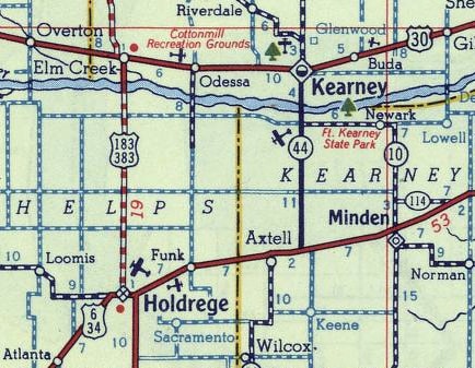
c. 1949, Gousha
|
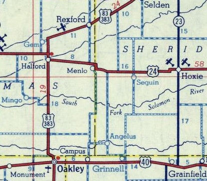
From there, US 183 went more or less due south, serving Phillipsburg and Hays. US 383 headed southwest to Norton, and at Selden joined with US 83, with which it was overlapped for another 40 miles south to US 40 at Oakley. So it is clear why US 383 was eventually decommissioned: it was dual-signed with other US highways for over half of its total length, and its solo segment was a Kansas intra-state route.
|
|
The north end of US 383 was not where US 183 meets US 30 today. This map illustrates the historic road alignments in Elm Creek:
|
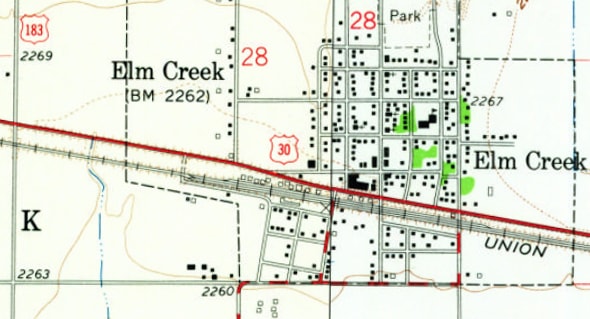
c. 1961, USGS
|
At the time of that map (and for many years before that) US 183 came in from the south on the red dashed road at bottom center. It turned due east on Clark Avenue, then north again to connect with US 30 via one of the two roads shown in red (the left road is Church Street, and the right road is Mill Street. If you know which one was signed for highway traffic, please contact US Ends .com).
|
|
Things have changed quite a bit in Elm Creek since that map was made. Today the road marked US 183 at upper left continues south, bypassing town to the west, and then curving to connect with the original US 183 off to the south. In 2000, US 183's junction with US 30 was a standard four-way at-grade intersection. But by 2005 there was a new viaduct carrying US 183 traffic over US 30 and the railroad. Here is a view looking north on US 183:
|
Sanderson, Aug. 2005
|
|
Today US 183 curves left here to its junction with US 30 on the west side of town. But originally it went straight ahead... and until 1964, that was also northbound US 383. Right in front of the red and white truck in the distance, the route turned right on Clark. The map above is not conclusive as to whether US 183-383 used Church or Mill to get to US 30 (although Church seems more likely). At any rate, the railroad crossings on both of those roads have been vacated now, making it difficult to get relevant photos. This shot was looking south from US 30 where Church historically connected across the railroad:
|
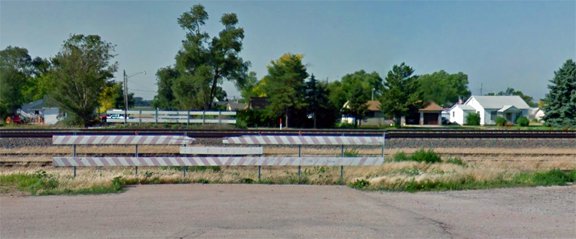
Google Maps Street View, June 2012
|
|
The former crossing is now barricaded, but it is likely that was looking along what was formerly the north beginning of US 383. Today the only RR crossing is at Tyler Street, which runs between Church and Mill. Heading east on Clark, an unusual sign was posted at Tyler...
|
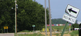
Sanderson, Aug. 2005
|
...but I am not aware of any evidence to support the notion that Tyler ever carried US 183-383. Rather, it is more likely that sign simply referenced the fact that today Tyler is the only road that provides access to the businesses along US 30. Church is one block behind the camera, and Mill is at the "T" intersection in the distance. Regardless of which road the highway used, northbound US 383 ended where it joined US 30. Northbound US 183 continued by turning left with westbound US 30 for about a mile, and then went north via its current route.
By 1960, Nebraska realized they had no use for the US 383 designation, so they truncated it to Alma (just north of the Kansas line). These photos were taken looking north on US 183 at US 136 (7th Avenue):
By 1960, Nebraska realized they had no use for the US 383 designation, so they truncated it to Alma (just north of the Kansas line). These photos were taken looking north on US 183 at US 136 (7th Avenue):
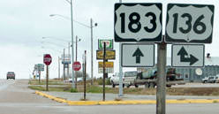
Sanderson, Nov. 2001
|
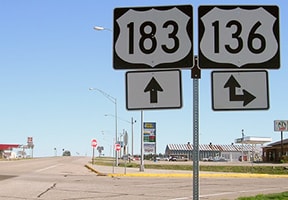
Morrison, Apr. 2017
|
Today US 183 skirts the west edge of town. Originally US 183-383 went right through town, using Church Avenue and Division Street. But when Harlan County Reservoir was built in the 1950s (just south of town), a new road had to be built to carry 183-383 traffic. So US 383 never ended right in town -- by the time it had been truncated to Alma, the highway had been rerouted to the new alignment shown there.
|
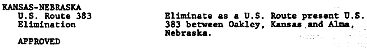
That intersection marked the north end of US 383 until its decommissioning. Here is that agenda item from the minutes of AASHTO's Oct. 1979 meeting (although reportedly KDoT did not remove signage until 1982):
Page originally created 2000;
last updated Dec. 7, 2023.
last updated Dec. 7, 2023.
