Historic US 60-70 endpoints in Los Angeles, CA
|
1927-1966
|
 |
Note: US 66 briefly had endpoints in Los Angeles too, but that is all covered on the main US 66 page.
The US 60 designation was extended west to California in 1932, ending in L.A. The map below shows it coming in along Valley Boulevard and Alhambra Avenue...
The US 60 designation was extended west to California in 1932, ending in L.A. The map below shows it coming in along Valley Boulevard and Alhambra Avenue...
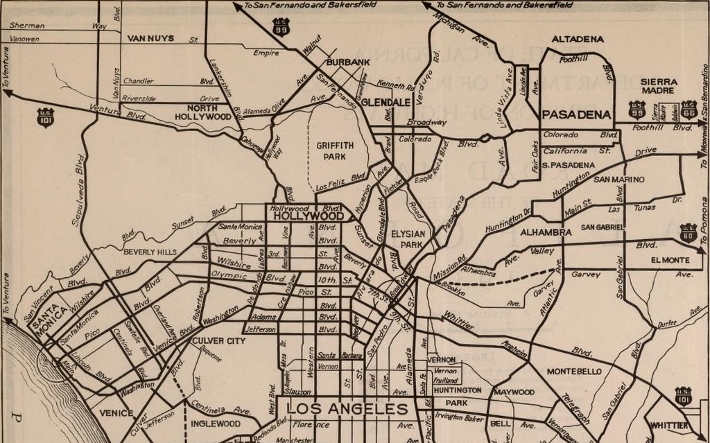
c. 1934, Caltrans
...but unfortunately there was no distinction between signed highways and average arterials. At any rate, wherever US 60 ended at that time, that would not have been the arrangement for long, as things had already changed by the time of the 1936 map:
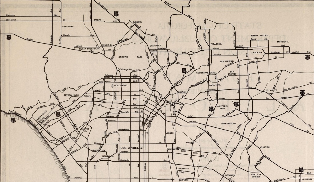
c. 1936, Caltrans
|
By 1934, US 70 too had been extended further west, also ending in L.A. Traffic came into town overlapped with US 60 and US 99, along what was then called Ramona Boulevard. US 60-70-99 passed under Macy Street, then turned west on Aliso Street, and then north on Mission Road, approaching Macy from the south. That was more clearly illustrated on this map from a few years later:
|
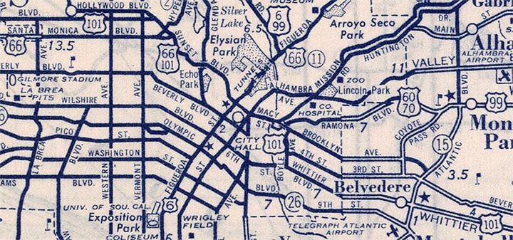
c. 1940, Rand McNally
|
|
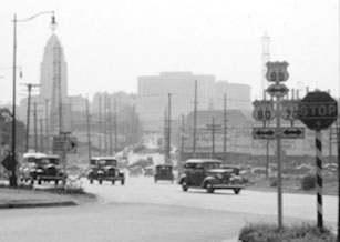
This photo was taken looking west from that final curve in Ramona Blvd. To the right was Macy (which carried US 101 at the time). But there was a grade separation with no access between the two roads, so US 60-70-99 continued ahead on Aliso (the landmark building in the distance is Los Angeles City Hall) and then intersected Mission. There, all three routes were directed north (right) to Macy. US 60-70 ended there, but US 99 continued along an overlap with US 101:
|
c. 1940, Automobile Club of Southern California; digitally reproduced and hosted by University of Southern California
|
|
Today most people would not even recognize the names of those roads. Macy is now called Cesar Chavez Avenue. Ramona was upgraded to a freeway -- initially it was called the "Ramona Freeway", but already by the 1960s it was known by today's moniker: the "San Bernardino Freeway", which now carries I-10. In fact, it would not be possible to take a photo from the same location as the photo above -- that intersection was completely erased by the interchange where the Hollywood, San Bernardino, and Santa Ana freeways converge. The Aliso corridor straight ahead is now occupied by an eastbound freeway ramp. In the opposite direction, Aliso continued east all the way to Pleasant, but today, all that is left of that segment of Aliso is a short stub (now called Summit Avenue), which branches off Pleasant and quickly dead-ends at the interchange. This interactive image is looking east on Chavez (nee Macy):
|
|
|
In 1926, this ornate bridge over the Los Angeles River replaced an earlier wooden structure: just in time to serve the US highway system that was soon to be commissioned. Macy became US 101, and just ahead at the traffic signal, the west beginning of US 60-70 was to the right on Mission. Traffic went south a block or two, then turned east, then north on Ramona, which passed underneath Macy about four blocks ahead.
Next we are looking north on Mission at Chavez: |
|
|
US 60-70 ended there, but US 99 continued to the left with northbound US 101; southbound US 101 was to the right.
That situation lasted for only 20 years at the most; the freeway interchange was already complete by the time of the aerial photo shown here: |
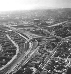
c. 1955, Caltrans Library
|
That was looking roughly north; the expressway coming from the bottom and curving off to the left over the Los Angeles River is modern US 101. The expressway coming in from the right is the San Bernardino. So that interchange marked the west end of US 60-70 for another 10 years or so, until those routes were truncated out of Los Angeles in the 1960s.
|
The other (smaller) bridge over the river was Macy (today's Cesar Chavez). Just this side of the San Bernardino, a road branches off Macy and comes toward the camera, parallel to the Santa Ana. That is Pleasant Avenue; US 101 traffic was routed along Macy and Pleasant until these freeways were built.
This photo shows the historic west beginning of US 60-70 from what is now the Santa Ana (northbound US 101): |
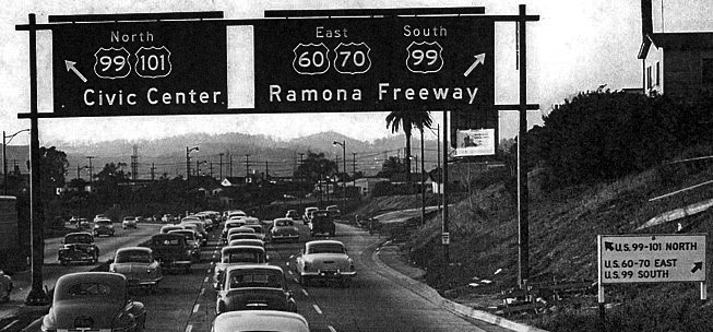
c. 1958 (attribution unknown)
|
|
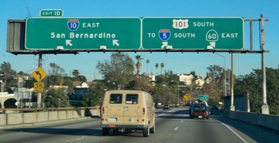
US 60-70 began to the right. Within a few years, the "Ramona" was renamed the "San Bernardino", and I-10 traffic was routed along it. This photo shows a more recent view from roughly the same location:
|
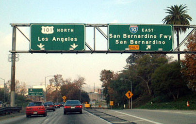
Field, Dec. 2001
|
|
These photos were taken from the opposite direction (south on US 101):
|
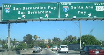
Field, Dec. 2001
|
Karners, Jan. 2012
|
|
To the left was the final Los Angeles beginning of US 60-70. US 70 was truncated out of California in 1964; US 60 was co-signed with I-10, and continued to end at that interchange until about 1966.
This last photo inspires us to reflect on transportation history in Los Angeles. It was taken from the aforementioned Cesar Chavez bridge (which carried historic US 101), whereas the downtown skyline provides a nice backdrop for the modern US 101 freeway in the middleground: |
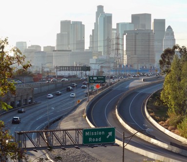
Karners, Jan. 2012
|
Research and/or photo credits: Jake Bear; Casey Cooper; Nathan Edgars; Tom Fearer; Andy Field; Karin and Martin Karner; Steve Riner; Mike Roberson; Dale Sanderson
Page originally created 1999;
last updated Feb. 14, 2023.
last updated Feb. 14, 2023.
