End of US highway 171 |
 |
|
Mileage: in 1989 AASHTO listed a figure of 179 miles for US 171. That closely matches our own 2020 measurement, which yielded 178 miles. At its maximum historical extent, US 171 was 182 miles long.
|
|
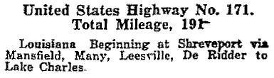
US 171 has been around since the beginning in Nov. 1926; here is its description from AASHO's Apr. 1927 route log:
|
|
|
Although US 171 has always run between Shreveport and Lake Charles, the specific endpoints in both cities have changed over the years. In Shreveport, US 171 originally connected with its "parent" route (US 71), as illustrated on this map:
|
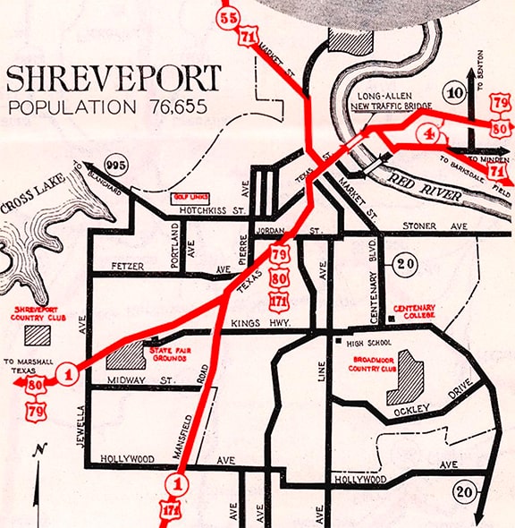
c. 1936, LADoTD
|
|
At the bottom of that map, US 171 was shown coming into the city via Mansfield Road. At the time, US 171 was overlapped with US 79-80 along Texas Avenue, then Texas Street past the courthouse, ending at Market Street, where it junctioned US 71. This photo was taken looking southwest on Texas in downtown Shreveport:
|

Karners, Apr. 2014
|
|
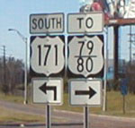
Southbound US 71 was to the left on Market; northbound was to the right; and US 171 began straight ahead. This next photo (a detail from the one at the very top of this page) was taken from roughly the same perspective, but a block further ahead. It shows the confirming assembly for traffic turning off US 71, including the first southbound US 171 marker:
|
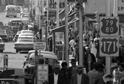
c. 1962, Shreveport Times Collection, LSUS Noel Memorial Library
|
(Note that was during the brief timeframe when Louisiana used white-on-green US route shields.) At the time, US 171 traffic was still following Mansfield (instead of veering off onto Hearne Avenue, as it does today). I suspect that change happened in about 1965, concurrent with the opening of I-20 through town, because of its interchange with Hearne. But by then US 171's overlap with US 79-80 had already been eliminated, by cutting 171 back to its current terminus at its junction with US 79-80. These photos were looking north on Hearne, at the intersection with Greenwood (US 79-80):

Morrison, Dec. 2001
|

Karners, Apr. 2014
|
|
Although there was no sign to indicate it, the US 171 designation ends there. The assembly visible at far left is shown close-up here:
|

Taylor, Mar. 2011
|
|
So US 171 no longer connects to its parent route, US 71. But there is no apparent reason why the US 171 designation does not continue straight ahead on Hearne, along what is now LA 3094, to the intersection with Market (US 71). In fact, in 2012 an LADoTD official explained that LA 3094 in Shreveport was the temporary route number assigned to the staged construction of the US 171 extension to US 71 in north Shreveport. Construction was completed in 1970, and in 1978 Louisiana sought AASHTO's approval to extend the US 171 northward along that road, but the proposal was denied. At last report, that entire northbound stretch of 3094 was signed as "TO US 71", and the southbound stretch had "TO US 171" shields. Heading the opposite direction, this shot shows the first southbound US 171 sign on Hearne:
|

Taylor, Mar. 2011
|
This photo shows the sign at the bottom of westbound I-20's exit 16 to Hearne:
Morrison, Dec. 2001
Note that US 171 is signed only to the south on Hearne. But actually it also goes north (right) for another quarter-mile to its terminus at Greenwood (US 79-80).
|
|
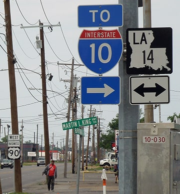
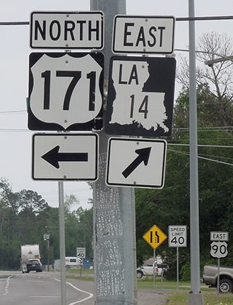
The south end of US 171 has always been in Lake Charles; this photo was looking south on Gerstner Memorial Drive (or MLK Highway) at Fruge Street:
|
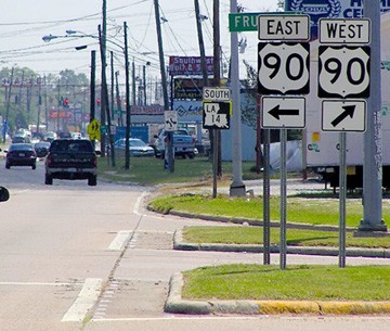
Taylor, Mar. 2011
|
Sanderson, Mar. 2023
|
|
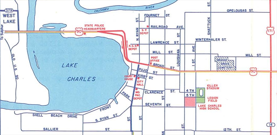
Today US 171 ends there, at its junction with US 90, while ahead the designation becomes LA hwy. 14. But US 90 traffic has been directed to use Fruge Street only since about 1965; prior to that US 90 ran along Broad Street, as shown on these next two maps:
|
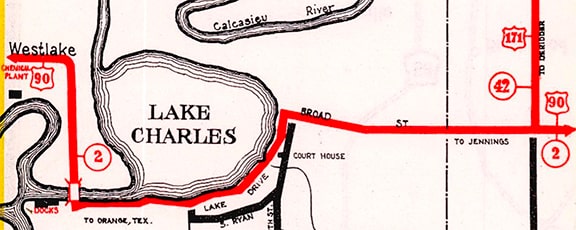
c. 1936, LADoTD
|
c. 1960, LADoTD
|
(Incidentally, on the left edge of that 1965 map, note the label for "Old US 90", which was illustrated on the 1936 map: it ran along Shell Beach Drive and "Front Street", which is now vacated, essentially replaced by today's Lakeshore Drive). So historically US 171 continued about a half-mile further south from Fruge. This image was looking west on Broad; historically US 171 began to the right on Gerstner/MLK. Originally LA 14 began to the left, but around 1965 it was extended to the right via former US 171 to the new US 90 on Fruge:
|
Sanderson, Mar. 2023
|
|
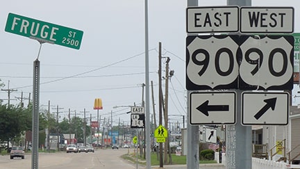
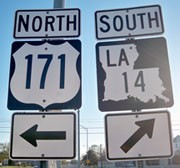
Heading the opposite direction (north on Gerstner/MLK), these views show the current south beginning of US 171 at Fruge:
|
Allen, 2000
|
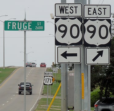
Sanderson, Mar. 2023
|
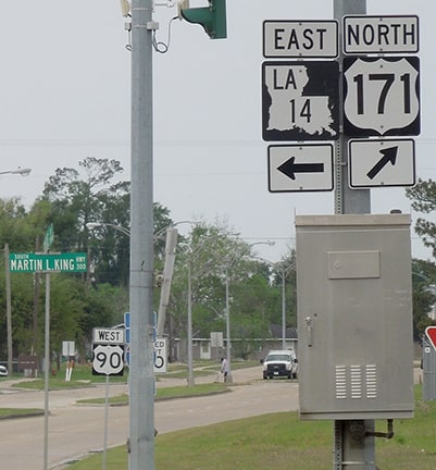
Drivers at that point are on LA hwy. 14, but the road ahead becomes US 171. These shots were taken looking east and west on Fruge (respectively):
Karners, Dec. 2009
|
Sanderson, Mar. 2023
|

Allen, 2000
|
Sanderson, Mar. 2023
|
|
Drivers turning to the north from there are immediately greeted with the first confirming assembly:
|
Karners, Dec. 2009
|
Research and/or photo credits: James Allen; Josh Bumgardner; Karin and Martin Karner; Andrew McDonald; Jeff Morrison; Dale Sanderson; Michael Summa; Stephen Taylor; "Urban Prairie Schooner"
Page originally created 2000;
last updated Feb. 7, 2024.
last updated Feb. 7, 2024.
