End of US highway 431 |
 |
Summa
|
1953-present
|
*US 431 was commissioned in July 1953 -- a relative latecomer to the US route system. Technically its south end was in Fayetteville TN for four months, as it was not extended to Dothan until Nov. 1953 (this article has much more of that history). Since then its endpoints have been in the same cities ever since, although in both cases the exact locations of the termini have changed.
Mileage: in 1989 AASHTO listed a figure of 556 miles for US 431. That closely matches our own 2020 measurement, which yielded 556.5 miles. Historically, when it went to downtown Owensboro, US 431 was 559.8 miles long.
Mileage: in 1989 AASHTO listed a figure of 556 miles for US 431. That closely matches our own 2020 measurement, which yielded 556.5 miles. Historically, when it went to downtown Owensboro, US 431 was 559.8 miles long.
|
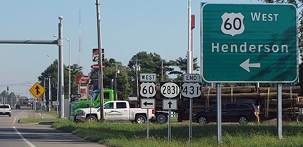
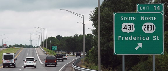
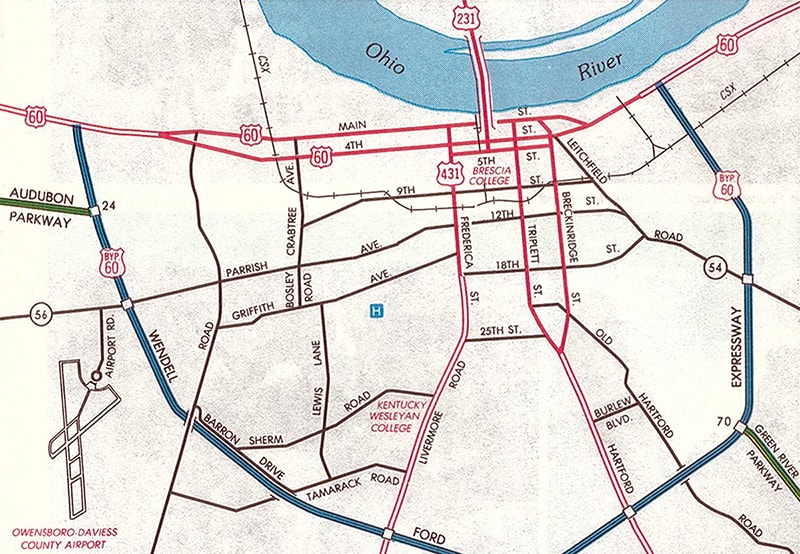
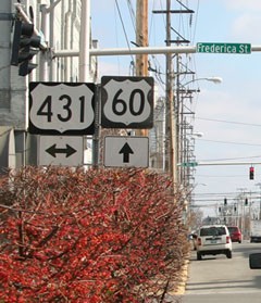
The north end of US 431 is in Owensboro; the route approaches town from the south on Frederica Street. In 2010 the designation was truncated such that it ends at the Wendel Ford Bypass (US 60). This interactive image is looking north on Frederica:
|
|
Elkins, Oct. 2016
By 2011 an "End" assembly had been posted just beyond the US 60 overpasses...
|

(detail)
...and by 2017 those references to US 60 had been removed and/or posted elsewhere:
|
Sweeney, June 2017
|
|
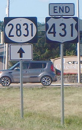
Hwy. 2831 is the current designation for the former US 431 to the north. This photo was taken from westbound US 60; US 431 traffic exits here and the route begins to the south (left):
|
Lintz, Aug. 2019 (sign for eastbound US 60 traffic is essentially the same)
|
|
Formerly the Wendell Ford Expressway was signed as "Bypass US 60", and mainline US 60 still ran through downtown Owensboro. When that was the case (and of course before the Expressway was built), US 431 continued north about three miles, to its junction with the original US 60 downtown:

c. 1957, KY DoT
|
c. 1988, KY DoT
|
|
There, US 60 split into the one-way pair of 2nd Street (westbound) and 4th Street (eastbound). This photo was looking north on Frederica where US 431 ended at westbound US 60 (2nd):
|
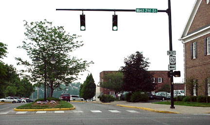
Elkins, 2000 (removed in 2011)
|
|
Eastbound US 60 (4th) is two blocks behind the camera. This shot was looking west on 2nd at Frederica, back when US 431 began to the left:
|
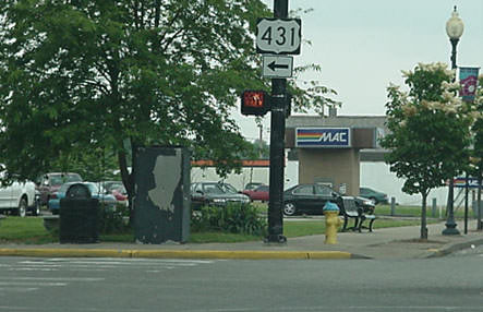
Elkins, 2000 (removed in 2011)
|
|
Drivers taking that turn to the left would junction with eastbound US 60 in two blocks, at 4th St. Just beyond that intersection was the first southbound confirming marker:
|
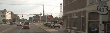
Google Maps Street View, Sep. 2007
|
|
Approaching that intersection from the west represented the north beginning of US 431 for traffic on eastbound US 60...
|
Kasprzyk, Dec. 2010
|
...although technically, yes, US 431 also continued to the left (for another two blocks). No US route traffic is directed through the central part of town anymore; US 431 now begins about three miles to the right (south).
|
|
The Dothan terminus, too, was in a different location until Ross Clark Circle was built (the bypass around that city). Photos and more info can be found on the Dothan page. Today US 431 comes in on the Headland Highway and then follows the Circle around to the south side of Dothan. Here, we are on southbound US 431, heading west at the intersection with US 231:
|
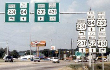
Nasiatka, Sep. 2003
|
Nasiatka, Sep. 2003
|
|
No "End" sign, but that is the end of US 431 (and that intersection also marks the south end of Business 431). Next, we are heading the opposite direction (east) on the Circle, or southbound on US 231:
|
Nitzman, Sep. 2006
|
|
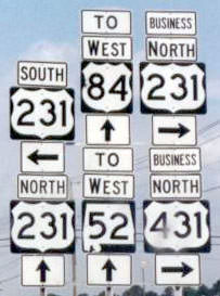
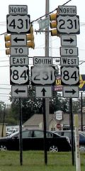
US 231 goes right (south) from there, while US 431 begins ahead on the Circle. Drivers continuing ahead on US 431 will see its first confirming marker; many assemblies in this area changed when AL 210 signage was added (that is ALDoT's designation for the entire Circle):
|
Nasiatka, Sep. 2003
|

Ivy/Nitzman, Sep. 2008
|
|
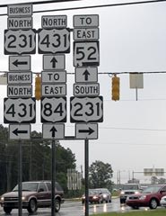
Next we are looking south on Business 231/Business 431; northbound US 431 begins to the left, heading east on the Circle...
|
Nitzman, Sep. 2006
...and here is the perspective for travelers heading the opposite direction (north on US 231):
|
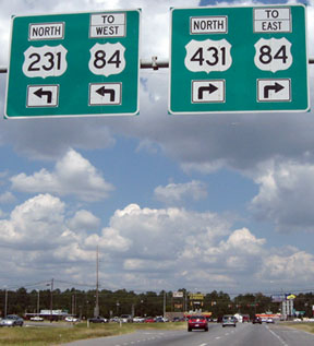
Ivy/Nitzman, Sep. 2008
|
|
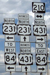
Those overhead signs have not weathered very well, as can be seen in the following more recent photo. Also note the directional ground signage, which includes one control city for each of the four US routes one can follow from this junction: Ozark is north on 231; Enterprise is west on 84; Ashford is east on 84; and Headland is north on 431. (However, no towns either direction on AL hwy. 52 are mentioned.)
|
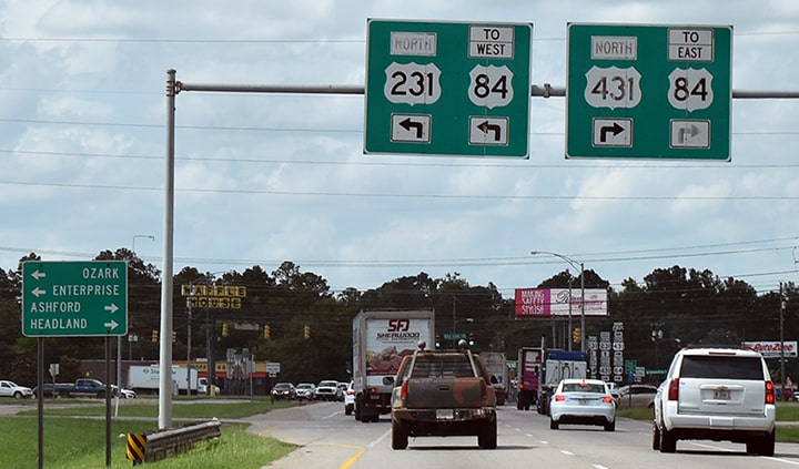
Nasiatka, Jun. 2021
|
|
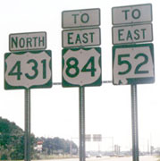
Off in the distance at far right is visible an assembly located at the junction itself; here are some close-up shots:
|

Nasiatka, Sep. 2003
|
Ivy/Nitzman, Sep. 2008
|
Research and/or photo credits: H.B. Elkins; Brent Ivy; Bruce Kasprzyk; Josh Lintz; J.P. Nasiatka; Alex Nitzman; Dale Sanderson; Michael Summa; Collin Sweeney
Page originally created 1999;
last updated Mar. 17, 2023.
last updated Mar. 17, 2023.
