Current and historic endpoints of US highway 4 in Portsmouth, NH
|
1927-present
|
 |
|
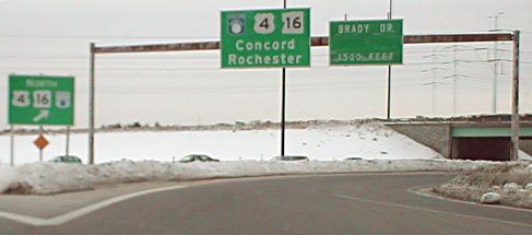
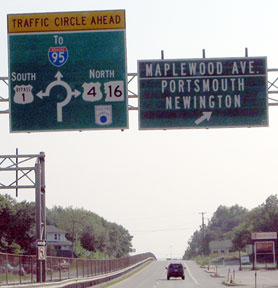
US 4 was commissioned along with the original routes of 1926. Its south terminus has always been in Portsmouth, although the exact location has changed. In 1940 the US 1 Bypass was built, but prior to designating it as such, NHDoT had to obtain AASHO's approval. Included in the material that NHDoT sent to AASHO was this map, which illustrates what was likely the original routing of US 4 south and east from Maplewood Avenue. Between North Mill Pond and the railroad, US 4 apparently split into a one-way couplet, with westbound traffic using what is now Vaughn Street and eastbound traffic staying on Maplewood. Both directions converged again along what is now Portwalk Place and Vaughn Mall. At Congress Street, US 4 was directed south, then east again on Middle Street, ending at its junction with US 1 (State Street):
|
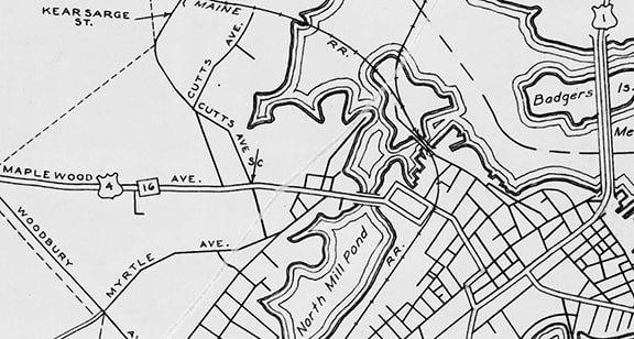
c. 1940, NHDoT
|
|
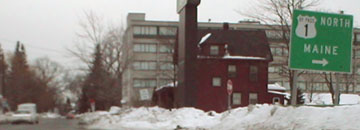
Mainline US 1 still uses State, and as of Sep. 2019 an interesting reference to the route was still posted there. In fact this was the only US 1 marker heading either direction through the downtown area; this image was looking north on Middle at State:
|
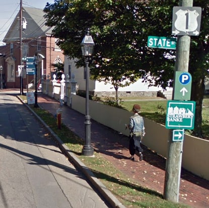
Google Maps Street View, Oct. 2017
|
|
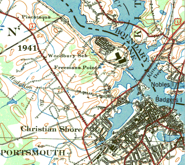
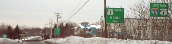
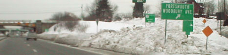
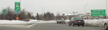
The bypass around Portsmouth Center was not signed as US 1 until 1941. At that time US 4 was realigned to follow Woodbury Avenue (instead of Maplewood), ending at Bypass US 1:
|
|
|
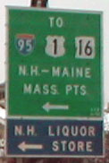
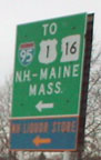
Today US 4 ends at the rotary in the center of the map, but it once ended just north and east of there. The following photos show that location; it is not clear if the interchange is original or was built in 1950. This first one shows the signage heading southeast on Woodbury at BYP US 1 (once mainline US 1) at the former east end of US 4:
|
Moraseski, Jan. 2003
|
|
To the right are connections with I-95 and the Spaulding Turnpike, or modern US 4; interesting how that is signed only as NH hwy. 16 but not US 4. Also, in order to go north on BYP US 1, one must turn right, then loop back around (behind the camera and to the left):
|
Moraseski, Jan. 2003
|
Here we are heading the opposite direction (northwest on Woodbury) at BYP US 1. (Likewise here one must go left and then loop back to the right in order to go north.) Straight ahead was once the east beginning of US 4:
Moraseski, Jan. 2003
|
Moraseski, Jan. 2003
|
Moraseski, Jan. 2003
|
Below are photos from old US 1 (now BYP US 1), both northbound and southbound, at the former east beginning of US 4:
Moraseski, Jan. 2003
|

Moraseski, Jan. 2003
|
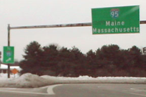
Between 1941 and 1956, US 1 was moved back to the old (and current) route and the bypass became BYP US 1. The New Hampshire Turnpike (now I-95) was built in 1950. This tied into BYP US 1 just south of US 4 (modern I-95 heading into Maine was not built until later). In about 1956, the Spaulding Turnpike was built, and US 4 traffic was moved onto it. A rotary (Portsmouth Circle) was built (probably in 1950) at the intersection of the two turnpikes and BYP US 1. From 1970-1972, current I-95 bypassing and north of Portsmouth Circle was built. Prior to that, I-95 traffic used BYP US 1 between the NH and Maine Turnpikes. Direct ramps from both directions of I-95 to US 4 west and US 4 east to I-95 south were built; traffic from US 4 east to I-95 north still has to use Portsmouth Circle but it is a right turn. Around 1992, NH 16 was moved onto the Spaulding, so US 4 and 16 both end at the same interchange. So US 4 has ended at Portsmouth Circle since probably 1956... at least officially. However, actual signage at the Circle currently indicates otherwise, and signage elsewhere suggests a couple other endpoints.
|
The road heading southwest from the Circle is an onramp serving both directions of I-95:
|
Moraseski, Jan. 2003
|
|
Southeast from the Circle is southbound BYP US 1...
|
Moraseski, Jan. 2003
|
...while northbound BYP US 1 heads northeast from the Circle:
|
Moraseski, Jan. 2003
|
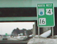
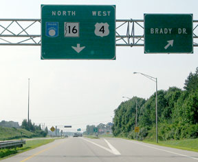
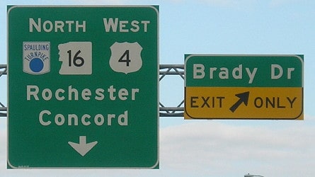
The road to the northwest from the Circle was formerly signed as if it was the east beginning of US 4, but for a time signage was changed to read that it is NH hwy. 16, leading TO Spaulding Tpk and TO US 4:
Moraseski, Jan. 2003
|

Field/Nitzman, Aug. 2007
|
|
In the past, if one went that direction, under the green I-95 bridges, the first westbound US 4 sign was posted immediately, but now it has been removed. The first confirming assembly is now further ahead:
|
Moraseski, Jan. 2003
|
Field/Nitzman, Aug. 2007
|
Morrison, Oct. 2016
|
|
Ahead traffic pinches into a single lane, in advance of the merging traffic lane coming in from I-95. It is at that point where signage changed to indicate that one is indeed on US 4 now (as well as the Spaulding):
|
Field/Nitzman, Aug. 2007
|
Morrison, Oct. 2016
|
|
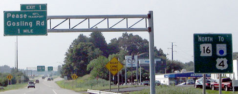
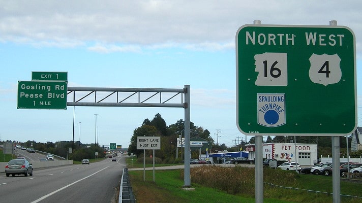
For a few years signage seemed to suggest that US 4 was no longer routed to the Circle, but rather that it hitches a ride with the portion of the Spaulding that provides a direct connection from here to I-95's exit 4. Signage from northbound I-95 backs up that theory:
|
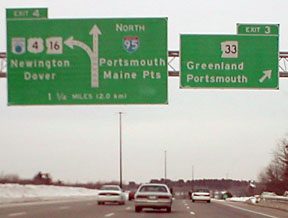
Moraseski, Jan. 2003
|
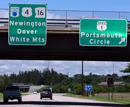
Note in these photos how the left-hand exit to the Spaulding is also referred to as if it is mainline US 4. (But then again, it is also referred to as mainline NH 16, which contradicts the signage shown above.) Control points for US 4 alternate between "Newington/Dover" and "NH Lakes/White Mountains":
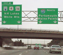
Moraseski, Jan. 2003
|
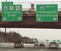
Moraseski, Jan. 2003
|
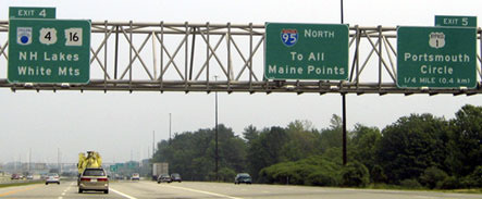
Buchanan/Nitzman, June 2005
|
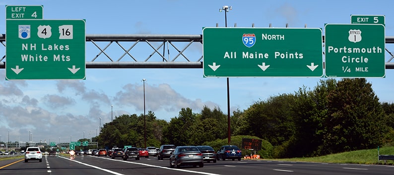
Nitzman, Aug. 2021
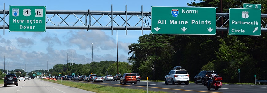
Nitzman, Aug. 2021
|
Direct access to US 4 is to the left, but we will exit right to Portsmouth Circle, just to see what signage is there:
|
Moraseski, Jan. 2003
|
|
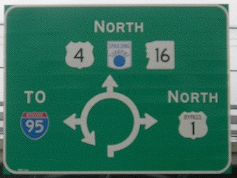
The map diagram posted on the off-ramp formerly indicated that it was mainline US 4 to the north...
|
Moraseski, Jan. 2003
|
|
...but later its replacement (along with all other signage here) was changed as well, to indicate "TO US 4". All these signs so far suggest that US 4 is now concurrent with the Spaulding, so now we will see whether signage on southbound Spaulding/eastbound US 4 backs that up. The BGS approaching the split is inconclusive...
|
Dienhart, Oct. 2015
|
|
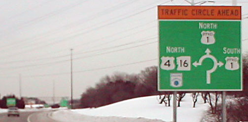
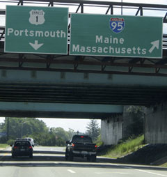
...but ground signage just ahead (at the physical gore) is interesting. Unfortunately I do not have any good photos, but the left-hand sign says "South NH 16 to North I-95", while the sign on the right says "South Spaulding Tpk to South I-95". No mention of US 4 whatsoever. So the east terminus of US 4 is somewhat ambiguous, at least in terms of how it is signed.
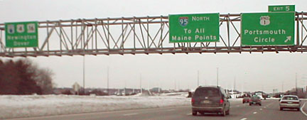
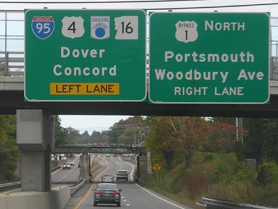
Following are some other approaches to US 4. Southbound I-95 must use exit 5 to access US 4:
|

Buchanan/Nitzman, June 2005
|
|
Drivers taking that exit must merge with traffic using the flyover from northbound I-95, and the first signage after that is shown here:
|
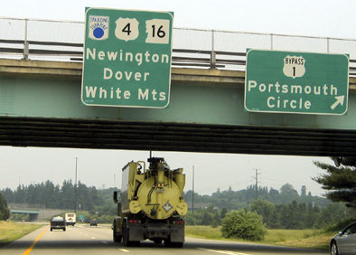
Buchanan/Nitzman, June 2005
|
Nitzman, Aug. 2021
|
|
The bridge in the distance carries southbound NH 16 traffic heading for the Circle. The right exit ahead connects northbound traffic to that road, taking it back south to the Circle. If one were to go that way, they would see this assembly:
|
Buchanan/Nitzman, June 2005
|
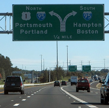
These next shots show US 4 signage posted for the benefit of drivers on northbound Bypass 1:
Morrison, Oct. 2016
|
Morrison, Oct. 2016
|
|
These last two photos show the approach to the rotary from southbound BYP US 1:
|
Field/Nitzman, Aug. 2007
|
Field/Nitzman, Aug. 2007
|
Research and/or photo credits: Carter Buchanan; Paul Dienhart; Andy Field; Dan Moraseski; Alex Nitzman; Dale Sanderson
Page originally created 2003;
last updated Sep. 10, 2021.
last updated Sep. 10, 2021.
