Geographic center(s) of North America |
 |
I have been interested in geographic centers since 1992, which is when I first visited the geographic center of the 48 states (a site near Lebanon, Kansas). Since then (nearly 30 years ago at the time of this writing) I have been aware of the purported geographic center of North America in Rugby, North Dakota, but until recently I had not journeyed to that part of the country. Now I'm glad that I waited, because in 2016 the geographic center of North America was recalculated using methodology that yields greater accuracy. As it turns out, the true geographic center of North America is indeed located in North Dakota, but it is over 100 miles away from Rugby. So by the time I finally had an opportunity in 2021 to get up that way, I had become aware of both sites, and I took the opportunity to visit both of them.
|
The Rugby site
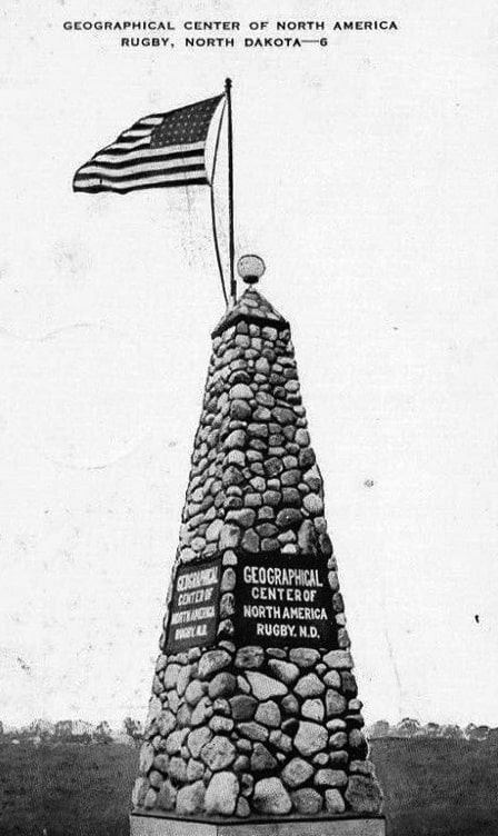
In the late 1920s/early '30s, someone with the U.S. Geological Survey used the rudimentary tools that were available at the time to determine that the geographic center of North America was about six miles west of Balta, ND. That was (and is) a very small town, which may explain why no one there appears to have made a serious attempt to capitalize on their newfound claim to fame. But some residents of Rugby (a larger town about 16 miles to the north) quickly grasped the potential for attracting tourists, and by 1932 they had erected a monument proclaiming its location as the geographic center of the continent. This image is from a 1940s postcard, so it likely shows the monument in its original form:
|
|
|
The fieldstones shown there appear to be more tightly-fitted than the ones on the current monument (as can be seen in some of the photos below).
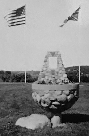
Today the term "North America" is understood to include Canada, the U.S., Mexico, the Central American countries down through Panama, and the Caribbean Islands. But for several decades, it appears that Rugby officials considered "North America" to refer only to Canada and the U.S., at least based on historic images of the geographic center monument. This 1938 photo shows another object (possibly a planter or a fountain) that was placed near the main obelisk. In the background only two flags are visible (Canada's national flag was the Union Jack until its current flag was adopted in 1965): |
|
|
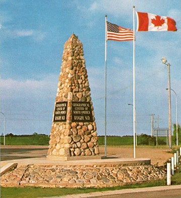
I have seen several historic photos (including one as late as 1985) that showed only the two flags. I did not find a date on this next image, but it was obviously post-1965:
|
|
|
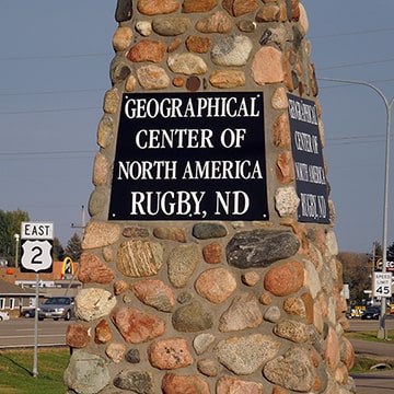
Incidentally, the precise location of the geographic center had always been something that Rugby preferred to de-emphasize (after all, it was known from the outset that the actual center was calculated to be in Balta, not Rugby). And this obfuscation of the details benefited Rugby in another way: it gave them the freedom to erect the monument at whatever location they deemed to be optimal for tourists. That was determined to be the town's main highway junction (where the east-west US Route 2 intersects the north-south state highway 3). So in the 1970s, when US 2 was widened to four lanes, there were no qualms about simply moving the monument a few yards away from its original location.
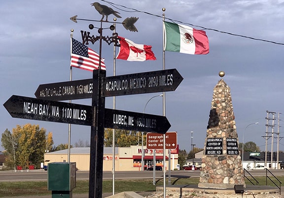
Back to the flags: I do not know when the flag of Mexico was added to the site, but it was definitely there by 2016, and it was there at the time of my 2021 visit: |
|
The placenames on that guidepost in the foreground merit some commentary:
- Lubec, Maine, is the easternmost settlement in the 50 states (not far from the easternmost point, which is Quoddy Head). But many parts of Canada extend much farther east than Lubec.
- Neah Bay, Washington, is the westernmost settlement in the 48 states. It lies just east of Cape Flattery, which forms the northwest tip of Washington State. But Cape Flattery is not the westernmost point in the 48 states; that honor goes to Cape Alava (which is about 15 miles south of Flattery). And of course there are many parts of Canada - not to mention everywhere in Alaska - that are much farther west than either of those capes.
Here is a closer view of the signage on the obelisk: |
|
It should be noted that there is no single, universally-accepted method of calculating geographic centers. There is no official agency with a need to calculate geographic centers, and the USGS has long since stopped involving itself with debates over those kinds of trivial matters. That was probably a good decision on their part, but one drawback is that it leaves the door open to spurious claims and misinformation.
The boat gets rocked
For over 80 years, Rugby maintained an uncontested claim to the geographic center. But starting in 2015, a couple different challenges to Rugby's claim began to surface.
For one thing, the mayor of Robinson (another tiny settlement in North Dakota) unilaterally decided that the geo-center of North America was actually right in his town. In fact - despite having no formal training in any relevant field of study - he was somehow able to determine that the precise location of the geo-center was occupied by a bar in town... which he just happened to own. I mean, what are the odds, right? Obviously it was just a joke, and it wouldn't even be worthy of mention here... except then it became more than a joke, with results that were more far-reaching.
The mayor/bar owner/geography expert decided to check with the US Patent and Trademark office to see who had rights to the term "Geographical Center of North America". As it turned out, Rugby did. Or more accurately: Rugby did formerly. Seems they had gotten a little careless and forgotten to renew their claim after 2009. So the mayor of Robinson plunked down a nominal sum, and by 2016 the coveted term had been officially registered to his proprietorship. When Rugby heard the news, they were understandably quite upset. Their lawyer contacted the mayor of Robinson, leading to a dispute that finally ended in 2018 with the trademark back in Rugby's hands.
During roughly the same timeframe, Dr. Peter Rogerson, a professor of geography, had published a couple relevant scientific works. One was a 2015 academic paper about how to define and calculate geographic centers, and the other was a 2016 article on his university's news site explaining how, when applying his methods, the true center of North America is actually just outside the town of - get this - Center, North Dakota.
The Center site
As the crow flies, Center is 102 miles southwest of Rugby (or 142 miles as the car drives). The town's name is entirely coincidental (it was named for its location near the center of Oliver County), but it is also amazingly serendipitous.
|
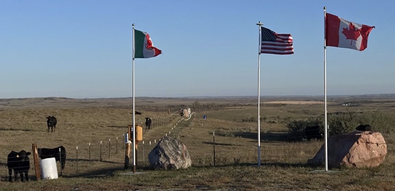
Officials from Center quickly began planning an appropriate response to their sudden and unexpected appearance in the spotlight. Rather than locating their monument at a commercially-strategic spot in town, Center decided to be more precise about it. The exact coordinates place the geographic center about four miles north of the town. Center has worked with the landowner to develop a small parking area just off state highway 48; this photo was taken from there:
|
|
|
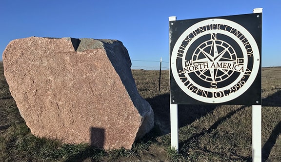
Note that Center has imitated Rugby by flying the three national flags. Visible behind the Mexico flag is an approx. 50-yard long corridor (fenced off to keep the cattle out) that allows geo-pilgrims to walk right up to the exact spot. A 15-ton boulder has been placed there, and right next to it a sign that explains the significance of this location. Center, not wanting to create animosity with Rugby, did not attempt to hijack the exact wording of Rugby's claim to fame. Instead, they have chosen the term "Scientific Center of America", which in my opinion was a very well-reasoned solution:
|
|
This is still a relatively new geographical point of interest, and this whole saga with the Geographic Center(s) of North America continues to unfold, so I am curious about what additional developments might take place over the next few years.
References and further reading:
More geographic centers:
- North America's Geographical Center May Be in a North Dakota Town Called Center (New York Times, Jan. 2017)
- The Debate Over the Geographical Center of North America (CBS News, May 2021)
- New Calulations Reposition the Geographical Center of North America (Smithsonian, Jan. 2017)
- Journey to the Geographical Center of North America (Afar, Jun. 2020)
More geographic centers:
Research and/or photo credits: Dale Sanderson
Page originally created 2021;
last updated Dec. 12, 2021.
last updated Dec. 12, 2021.
