US highway endpoints in the San Francisco Bay Area, CA
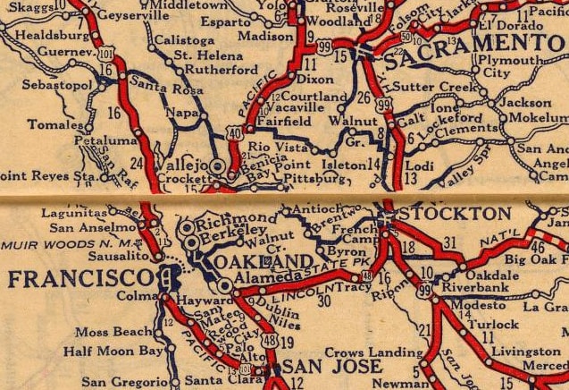
Northbound US 101 traffic departed San Francisco from the Hyde Street Pier. That is now part of a National Historic Site, and an old US 101 sign is posted at the old ferry landing. US 48 [i] began in San Jose and served the East Bay as far as Hayward before turning inland towards Stockton. US 50 ended in Sacramento.
|
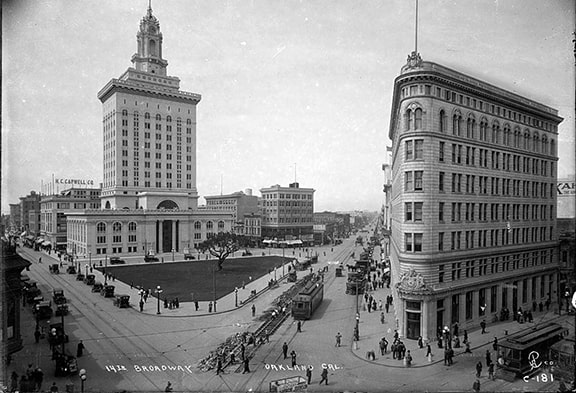
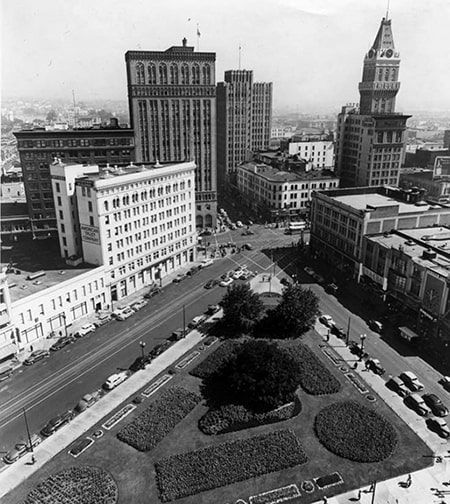
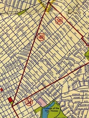
US 40 continued west from Sacramento into the Bay Area. However -- while this route did provide a connection to the Berkeley-Hyde Street ferry -- US 40 itself was not directed into San Francisco. Rather, its terminus was in the center of Oakland. It was routed down San Pablo Avenue, ending essentially at the City Hall. This photo was taken a few years before the US route system was commissioned, but it provides a good impression of how US 40's original western terminus looked:
|
That was looking northwest, with 14th at lower left and Broadway at lower right. At the time, San Pablo (and US 40) began at this five-way intersection, continuing straight ahead. (Those first two blocks of San Pablo are no longer open to vehicle traffic, as they are now part of Ogawa Plaza.)
|
|
Note that, although that was the west terminus of US 40, it was not the westernmost point on the route. San Pablo Av extends mostly north, but also a bit west, until it reaches the city of San Pablo. At that point, US 40 reached its westernmost point and began a gradual curve to head more easterly.
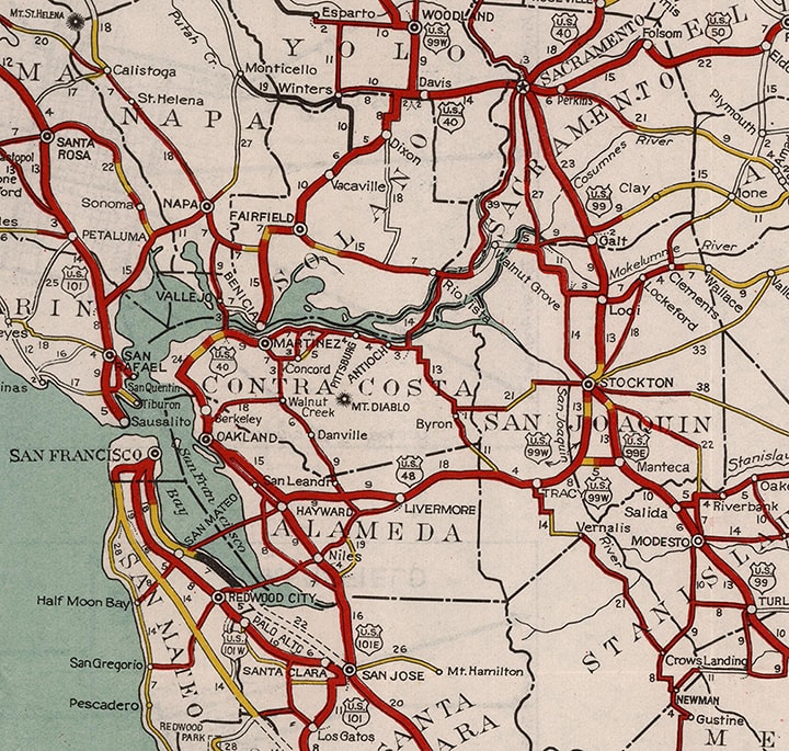
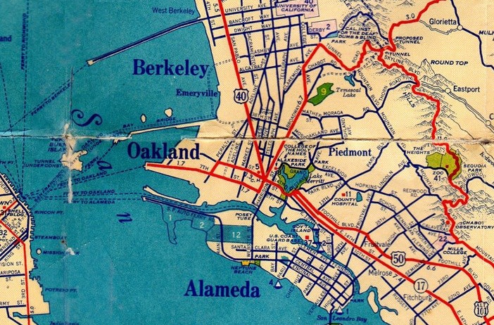
In about 1929, US 101 was changed to a split route. North from San Jose, the original mainline US 101 serving the Peninsula became US 101W. US 48 was truncated to Hayward; its former route between there and San Jose was replaced by US 101E, which then continued further north to Oakland, crossed the Bay via ferry, and reconnected with US 101W in San Francisco: |
In 1930, AASHO approved an extension of US 50 to the west; here is that item from the minutes of their meeting in Nov. of that year:
|
Here is another view of the five-way junction that now served as the west end of both US 40 and US 50. The view here is to the southeast, from a vantage point in City Hall. Traffic coming from the lower right corner was heading east on 14th. Drivers coming from the lower left were heading south on San Pablo, which carried westbound US 40:
|
Those two roads joined at a third road, Broadway (which runs across the photo). US 40 ended there, but drivers taking an easy left onto eastbound 14th (away from the camera) would have found themselves at the west beginning of US 50 (until 1936, which was a few years before that photo was taken).
|
|
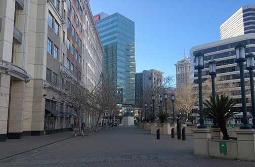
Next is a modern ground-level photo looking south along what was formerly San Pablo, before it was closed to vehicle traffic (City Hall is off the right edge of the photo). This was the original westernmost segment of US 40, which terminated at the intersection visible in the distance:
|
|
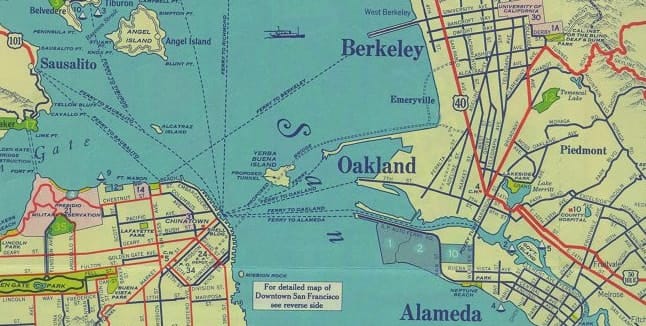
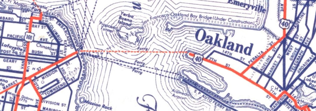
The preceding 1935 map indicated that was still the case, except US 101E may have briefly been re-designated as US 101 Alt. However, it should be noted that there is much uncertainty about how US highways were routed and signposted in the Bay Area prior to the mid-1930s (for more information and research, please see this Gribblenation blog post). For example, this next map (also dated 1935) indicated that US 40 traffic was instead directed off San Pablo via Peralta Street to 7th Street, and then via ferry across to San Francisco. The implied endpoint was on Market Street at Van Ness Avenue:
|
|
Note that 7th east of Peralta was also shown to be a signed highway route, and a US 50 label (outside the cropped area of that map) implies that junction marked the west beginning of US 50. But then this next map, from just one year later, indicated that US 40 still went to Oakland City Hall, while US 50 was rerouted along a corridor approximating what would later become MacArthur Boulevard. This not only would have allowed traffic to bypass downtown Oakland, but it also provided a logical approach to the foot of the new bridge that was about to open:
|
CalTrans did not assume maintenance of highways within Bay Area cities until 1935, so US route endpoints prior to that are questionable at best, if not unknowable. What is known is that construction on the Bay Bridge began in 1933, and it opened to traffic in 1936. So I consider the endpoints of US 40 and US 50 during the early 1930s to be a footnote, because whatever the arrangement was, it was very temporary...
|
|
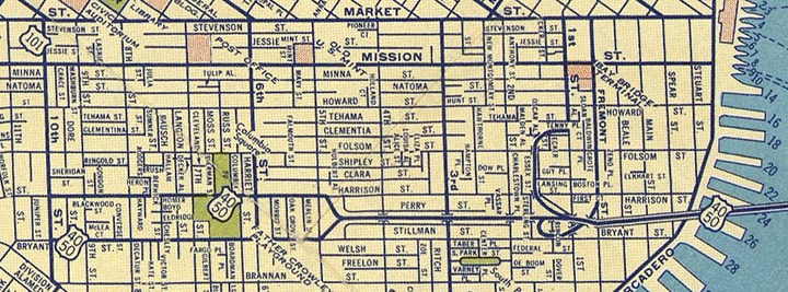
...as soon as the Bridge was opened, both US 40 and US 50 traffic was directed onto it, and both routes were extended to San Francisco. Originally the roadway was elevated only to about 4th Street; west of there traffic coming into the city dropped down to the surface, aligned with Harrison Street:
|
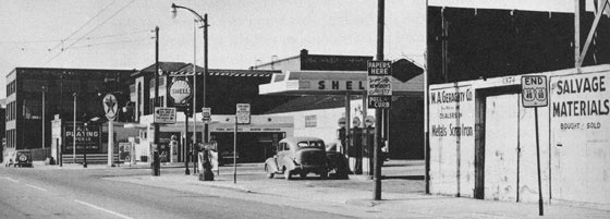
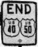
This historic photo of that endpoint was taken by George R. Stewart, and published in his 1953 book U.S. 40: Cross Section of the United States of America (Riverside Press, Cambridge MA). At far right is an "End" marker, and slightly left of center are two more highway signs:
The shape of that "California US 101" marker looks a little unorthodox (but it could be that the quality of the photo and the print job caused some object distortion). The other sign gives destinations both ways along US 101. The arrow to the right says "Civic Center", and the cities indicated by the left (or south) arrow are:
San Mateo - 18
San Jose - 47
Los Angeles - 441 (the distance is significantly less now via I-5, but 441 is the correct mileage if one were to follow US 101 all the way.)
Some of Mr. Stewart's comments on his page containing that photo are relevant to the purpose of this website, and are thus reproduced below:
U.S. 40 ends in San Francisco, on Harrison Street at the corner of Tenth.
After the beauty of fields and forests, after the grandeur of mountain and desert, after the dignity and power of the city as seen from the Bay Bridge itself - here, after three thousand miles, in full anticlimax, is the end, in a scene that is devoid of beauty or grandeur or power. Even the sign announcing the end of the two great highways is slightly knocked askew.
Others, before, have noted the anomaly, and have commented upon the irony of a great highway that crosses the whole of the United States, to end at a junk yard. To be a little more charitable, and also more accurate, we may at least say that U.S. 40 ends, characteristically, at a service-station, or even two service-stations.
Or, we may also say, it ends from the highway-planners' point of view, where it meets U.S. 101, as the sign here shows. This in itself may be considered no bad ending, for U.S. 101, a Canada-to-Mexico route, is another great highway.
By being carried only a few miles farther, over already paved streets, U.S. 40 could be made to end at some magnificent location overlooking the Golden Gate and the Pacific Ocean. The transcontinental tourist could thus be made to feel that he had been brought to a climactic ending. By being carried only a half mile to the north, the highway could end at the Civic Center, in a scene of considerable urban grandeur.
Yet perhaps the present end is the most fitting of all. U.S. 40 is no swank boulevard, no plush parkway. If there is a romance about it, this is the romance of the modern world, busy with its own affairs. U.S. 40 is the thoroughfare of a hundred thousand trucks and buses, and of a million undistinguished coupes and sedans, convertibles, and station-wagons - driven east, driven west - for business or for pleasure, twenty-four hours a day, in a seven-day week. Most of all, U.S. 40 is a working road, and when it dead-ends into U.S. 101, its job is finished. Why should we seek an artificial climax? Work done, why should such a road - or a man - make heroic gestures? End - U.S. 40.
|
Stewart's book is full of the same kind of musings and observations from all the way across the country -- made all the more fascinating when one considers the timeframe during which it was written and compares that to the way things are today.
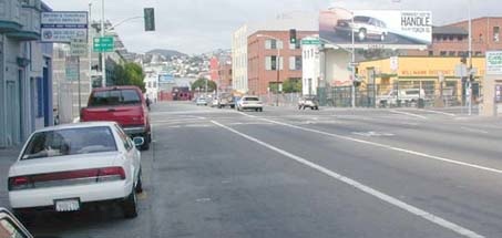
This next photo was taken looking the same direction as the one above: |
|
Note that the yellow, white, and brown buildings visible on the right side of that photo were also shown in the historic photo above. However, as of 2010, the yellow building (the historic Shell gas station) had been replaced with an office building. But that is generally what this old endpoint of US 40-50 looks like today. The green sign in the middleground (mounted on the signal mast) directs drivers to the route that once ran along 10th -- it says "US 101 south; San Jose: left 2 lanes". Harrison is one-way westbound, so the west beginning of US 40-50 was one block to the left, on Harrison's eastbound counterpart: Bryant Street. The view here is to the south on 10th at Bryant:
|
|
|
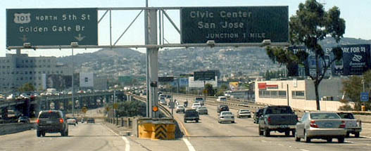
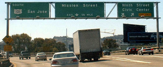
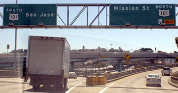
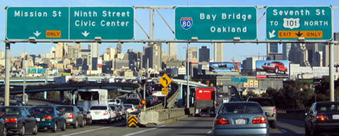
That was southbound US 101, which at the time continued straight ahead, but is now routed along the Central Skyway (an overpass for which is visible in the distance, and the road angling to the left is an on-ramp). US 40-50 began to the left on Bryant. Traffic was routed along this one-way pair until about 1954 (or one year after Stewart's book was printed). That was when the freeway coming off the Bay Bridge (now known as the James Lick Skyway, or I-80) was extended to the new US 101 (which in turn had been moved off Portero Avenue and onto the Bayshore Freeway). Here is a series of photos from westbound I-80...
|
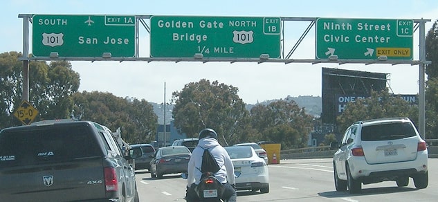
...although this freeway was built a few years before there was such a thing as I-80, so it was originally signed as US 40-50. As was illustrated on the map above, originally traffic had no option other than to drop down to Harrison at 5th, a movement represented now by the left-hand exit shown above. (Incidentally, that is not really US 101, but it is the shortest way to get there -- if not the fastest, depending on Skyway traffic.) The freeway ahead is the extension built in 1954. When that happened, US 40-50 was extended along with it, probably ending at the next exit, shown here:
|
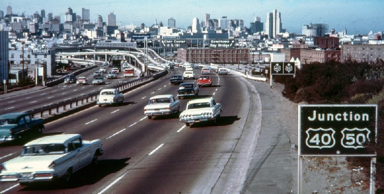
Despite the signage, US 101 actually continues to the left there via the Central Frwy. I-80 begins to the right, and that was the final west beginning of US 40-50 before those designations were truncated out of San Francisco in about 1971. This image shows the same perspective, as photographed in 1962:
|
Research and/or photo credits: Chris Elbert; Tom Fearer; Andy Field; Laurence Maller; Dan Moraseski; Jeff Morrison; Alex Nitzman; Mike Roberson; Dale Sanderson; George R. Stewart; Mike Wiley
Page originally created 2000;
last updated Aug. 17, 2023.
last updated Aug. 17, 2023.
