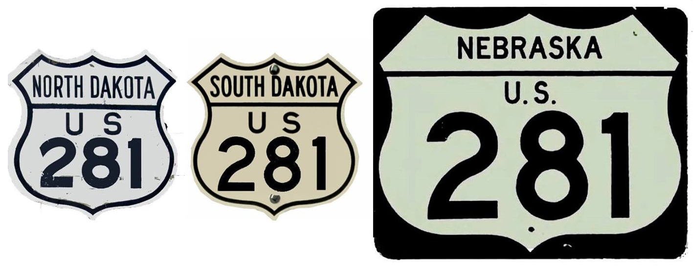
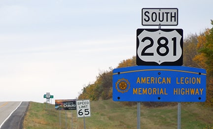
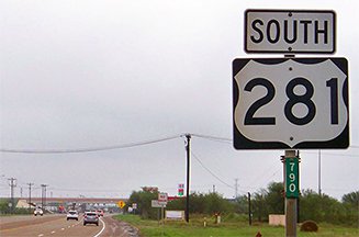
End of US highway 281 |
 |
Summa
|

Summa
|
|
1931-1932
|
1932-1935
|
1935-1939 (north segment)
|
|
1934-1939 (south segment)
|
1939-1964 (joined segments)
|
1964-present
|
Claim to fame: it is a bit misleading to refer to Brownsville as the "south" terminus of US 281, because Texas signs US 281 as a north-south route only from Pharr northward. At Pharr, US 281 heads eastward to Brownsville, and Texas signs that segment as an east-west route. Not only that, but US 281 Spur heads west from Pharr to the border crossing at Hidalgo. But Texas does not sign that segment as a Spur; rather they sign it as if it is mainline US 281. What this means for traffic coming into the U.S. from the Pharr-Reynosa International Bridge is this: drivers soon come to an interchange where the signs indicate they can head three directions on US 281! Right (east) to Brownsville; left (west) to Hidalgo; or straight (north) through downtown Pharr to I-2 and I-69C.
|
Mileage: US 281 is the longest continuous three-digit US route (that is an important distinction, because adding the two segments of US 287 yields a greater length, but those segments are non-contiguous). In 1989 AASHTO listed a figure of 1901 miles for US 281... however, that included the mileage of US 281's associated business/spur/alternate routes. According to the state subtotals on AASHTO's 1989 spreadsheet, mainline US 281's actual end-to-end total at the time was 1872 miles.
|
That is reasonably close to our own 2020 measurement, which yielded 1865.6 miles (reroutings and realignments likely explain the difference). That puts the midway point about 5.5 miles north of Medicine Lodge, Kansas.
|
|
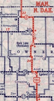
US 281 was commissioned in 1931. At the time its north terminus was in Rocklake, not far south of the Canada border. Documents in the AASHO archives indicate this was because there was not yet a Canada port of entry at Hansboro. Instead of bypassing the town and the lake to the west (as it does today), US 281 ran along the east shore of the lake, wound its way through Rocklake, and ended at ND state hwy. 5 (which at the time skirted the east and north sides of town). This image was looking west on Main Street, approaching where the road crossed a no-longer-extant railroad. This was westbound ND 5, which continued to the right on what is now 67th Avenue NE. Straight ahead on Main was the north beginning of US 281:
|
Sanderson, Oct. 2021
|
|
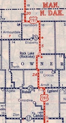
The next year (1932) AASHO's route log indicated that US 281 had been extended north of Rocklake to the border. But for some reason, according to the following maps, the road between Rocklake and the Canada border was designated only as ND hwy. 4 until 1939, when the US 281 designation was added:
|
US 281 was extended to the Canada border by turning left from the intersection pictured above. ND 5 split off by heading due west through Elsberry (a now-abandoned railroad siding) to join its current route near Armourdale, but US 281 continued due north until it reached what is now CR 43. There it went west to Hansboro, and then north to the port of entry (which is also called Hansboro; the Canadian counterpart is known as Cartwright). Below is a photo of the Hansboro border crossing:

Slaathaug, Nov. 2005
It was sometime in the 1950s when US 281 bypassed Rocklake to the west, and joined with ND 5 on a new diagonal alignment between Rocklake and Armourdale. This photo was looking west on northbound US 281/westbound ND 5, just south of Armourdale:
|

Slaathaug, Nov. 2005
Today US 281 continues ahead, but it once turned north here, via what is now ND 4, through Armourdale and Hansboro. Its terminus continued to be at the port of entry north of Hansboro until 1964, which is when US 281 was rerouted along its current path: west from Armourdale with ND 5, through Rolla and Belcourt, all the way to Dunseith before finally resuming northward. This image shows the last northbound US 281 marker, which was posted about 10 miles north of Dunseith at the east terminus of ND hwy. 43:
|
Sanderson, Oct. 2021
|
|
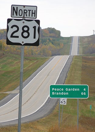
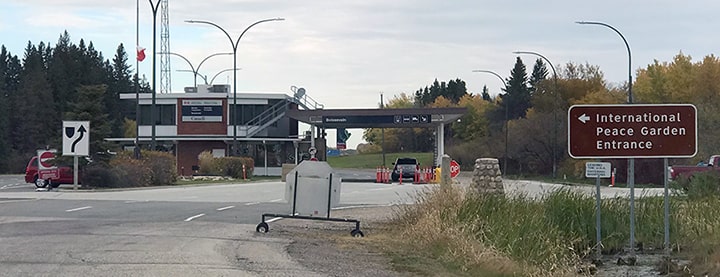
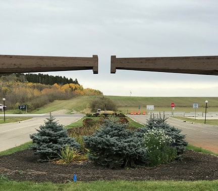
US 281 continues four more miles north to the Canada border (right at the entrance to the International Peace Garden). These shots were taken approaching the north end of US 281 at the Peace Garden (aka Dunseith) port of entry:
Taylor, 2000
|
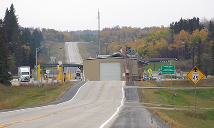
Sanderson, Oct. 2021
|
|
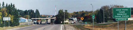
Perhaps the landscape is not what one would expect to find in the middle of the Great Plains. US 281 runs through an isolated outcropping of hills known as the Turtle Mountains. It continues north as Manitoba hwy. 10, bound for Brandon. The Canadian port of entry just ahead is called Boissevain; it is shown here:
|
Sanderson, Oct. 2021
|
|
The photo below was taken from the Peace Garden, looking east along the US-Canada border. The stop sign visible in the background is at US 281, where...
Sanderson, Oct. 2021
|
...one can look north at the end of the route...
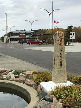
Sanderson, Oct. 2021
|
...or south towards the beginning of US 281:
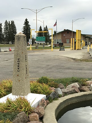
Sanderson, Oct. 2021
|
|
These photos show the first southbound US 281 sign:
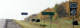
Taylor, 2000
|
Sanderson, Oct. 2021
|
|
On its south end, US 281 through South Dakota was originally directed east at Wolsey to Huron, then south via modern SD 37 through Mitchell, ending at its junction with an older alignment of US 18 near Tripp. AASHO would not allow the route to extend any farther south because of a privately-owned toll bridge south of Tripp:
|
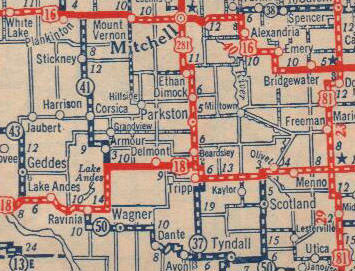
c. 1932
|
|
The road designated SD hwy. 41 at the time of the map above now carries US 281 traffic. Within about a year, South Dakota had changed US 281 to follow that routing, so that the designation could be extended further south through Nebraska; at that time its south terminus was at Red Cloud (the last town before the Kansas line). US 136 did not yet exist; rather the reason 281 ended in Red Cloud is because the Kansas segment of the route was mostly unimproved dirt, and AASHO did not yet consider it to be of sufficient quality for interstate traffic. This photo was taken looking west on US 136; starting in 1932 the south beginning of US 281 was to the right:
|
Sanderson, Jun. 2022
|
|
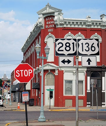
In 1934 or '35 Kansas extended the US 281 designation south (apparently without AASHO approval) to its junction with US 36 in Lebanon, where it remained for the next three years:
|
c. 1936, KSDoT
|
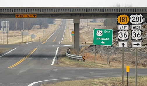
Sanderson, Mar. 2018
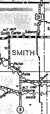
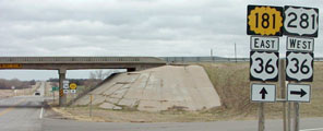
Today the US 281 designation continues south from there via westbound US 36 to Smith Center. But during the 1930s, US 281 ended there (of course the view has changed a bit; there was no grade separation at the time).
|
|
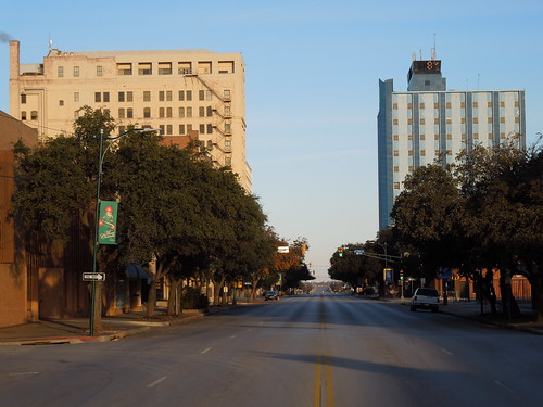
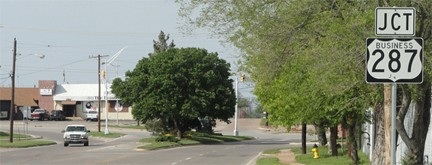
In 1934 AASHO commissioned a separate southern segment of US 281, running through Texas from Wichita Falls to Brownsville (it was in 1939 that the two segments of US 281 were joined between Wichita Falls and Lebanon). In Wichita Falls, US 281 came in on Old Jacksboro Highway (now Loop 473). But originally -- instead of curving to the northeast -- traffic continued due north on Holliday Road. At Holliday Street, drivers were directed northwest to 10th Street, and the junction with the original US 82-277. Most likely all three routes were co-signed northeast on 10th, and US 281 ended at Scott Avenue, which carried US 370 (today's US 287). This image is looking northwest on Scott (now Business 287):
|
 |
|
To the left on 10th was Wichita Falls' original terminus of US 281. But in 1938 Old Jacksboro's bridge over Holliday Creek opened, and US 281 was redirected to use that route. 1938 was the last issue of the official TXDoT travel map to show US 281 using Holliday and 10th (compare the relevant maps). The 1939 issue shows US 281 traffic had been redirected along Old Jacksboro, ending at Scott. This photo was looking north on Old Jacksboro:
|
Sanderson, Mar. 2012
|
For a short time, the north end of the south segment of US 281 was at the intersection ahead. The white pickup had just turned off from eastbound Scott; historically the driver would have been traveling on eastbound US 370, turning onto the north beginning of US 281. (Here is another image from that junction.) Maps from the next year (1940) show a couple changes: US 281 was extended north out of Wichita Falls, and US 370 had been subsumed by 287. So US 281's Wichita Falls endpoint was always at its junction with US 370; by the time that route had been renumbered to US 287, US 281 had been extended north. A bit south of town, Old Jacksboro Road connects with modern US 281, which leads all the way down to Brownsville...
|
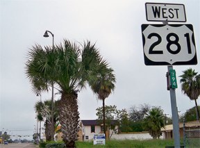
...however, based on the majority of actual posted signs, the "south" end of US 281 is not in Brownsville. It is actually at Fays Corner TX (which is technically within Pharr city limits, although quite a ways south of downtown, and actually closer to Hidalgo, which is just to the west). Officially, the highway heading west from Fays Corner to Hidalgo is "Spur US 281", whereas mainline 281 goes east to Brownsville. However, signage in the area tells a different story. Heading south out of Pharr on Cage Boulevard, this is the last US 281 shield marked "south":
|
Karners, Dec. 2014
|
|
Barely visible in the distance is an overpass running perpendicular; that is called Military Highway. According to official route definitions, at that junction US 281 traffic should be directed left (east) towards Brownsville. Drivers heading right (west) towards Hidalgo are supposedly on Spur US 281...
|
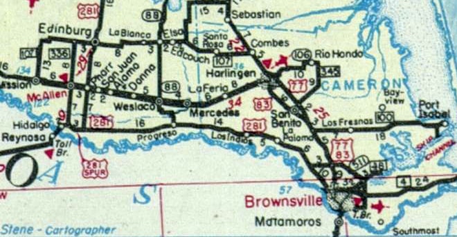
c. 1950, TXDoT (maps prior to this showed US 281 was incomplete between Fays Corner and Progreso)
|
|
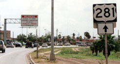
...however, these roads are actually signposted as if mainline US 281 goes three directions from Fays Corner. It is a very irregular situation (although it is not unusual for highway signage in the Rio Grande Valley to be non-standard and haphazard). Here is how the junction was formerly signed:
|
Taylor, 2000
|
|
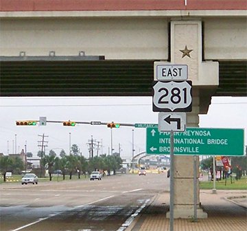
That was taken before the overpass was built, back when the north-south segment of US 281 ended at a "Y" junction with the east-west segment. The right turn towards Hidalgo was marked as "West" US 281, and the left turn to "East" US 281 was up ahead (although that was actually one of the few places in the Valley where US 281 was signed with any directional tab). At the time there was no road continuing straight ahead (south) from here, but since that photo, a highway has been extended ahead to a new border crossing known as the Pharr-Reynosa International Bridge (the arms of the old "Y" junction have been vacated, but their historic alignments are still clearly visible on aerial photos). Here is a more recent photo from essentially that same perspective:
|
Karners, Dec. 2014
|
|
The new customs station is visible in the background. According to signage, that junction is the terminus of the north-south portion of US 281, which ends at its junction with the east-west segment of US 281... very strange. If one turns to the right there, they will soon see that the trailblazers do include directional tabs; here is an example from Coma Avenue in Hidalgo...
|
Karners, Dec. 2014
|
|
...but then look what happens when drivers reach the west end of Coma at International Boulevard (aka TX Spur 115):
|
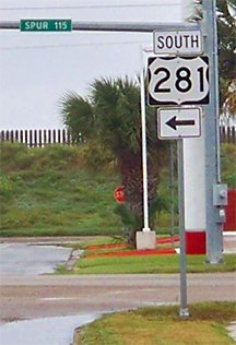
Karners, Dec. 2014
|
|
Great, so the final stretch to the border crossing is back to a north-south route. Look, TXDoT, this is absurd: you don't change the signed direction of travel every time a highway makes a turn. If you think people are going to get confused, just forgo the directionals, like you did in the past:
|
Taylor, 2000 (gone as of 2015)
|
|
That was looking south on International, but now that stretch has been signed as "South US 281". Despite that, just ahead is technically the "west" end of Spur US 281, shown close-up here:
|
Karners, Dec. 2014
|
|
Heading the opposite direction, the first US 281 sign in Hidalgo was formerly signed "North":
|
Taylor, 2000
|
|
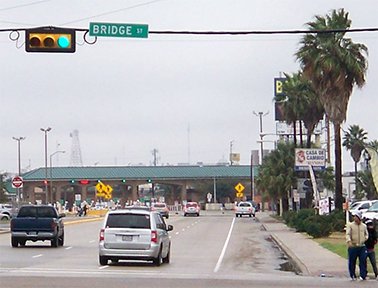
That was at the wide turn to Esperanza Avenue (which incidentally, until 1979, was used by 281 traffic to the east, and then Bridge Street to the north). But as of 2015 there was no longer any reference to US 281 there. Now there is no signage until the junction where traffic is directed to turn east on Coma:
|

Karners, Dec. 2014
|
|
Note that none of these signs mark this route as "Spur US 281". We will take that right turn and go back towards Fays Corner. In a couple miles we encounter this sign:
|
Karners, Dec. 2014
|
|
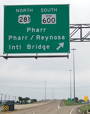
Based on signage behind us, we are ostensibly already on US 281, and this sign suggests that we need to exit here in order to continue on that route. But when we do that, here is what we see on the off-ramp:
|

Karners, Dec. 2014
|
So US 281 is not only behind us, but also to the left and straight ahead... meaning: if we had simply wanted to stay on eastbound US 281, then we should not have exited at all. Signage heading the opposite direction (west on US 281) is the same. This is a situation in dire need of renumbering. One obvious solution would be to have the US 281 designation continue south from Fays Corner (replacing what is currently TX 600), ending at the border crossing. The TX 48 designation could then be extended west from Brownsville all the way to Hidalgo, replacing the entire east-west segment of US 281.
Research and/or photo credits: Nathan Edgars; Chris Geelhart; Karin and Martin Karner; Jeff Morrison; Dale Sanderson; Kenneth Slaathaug; Michael Summa; Stephen Taylor
Page originally created 2001;
last updated Dec. 3, 2023.
last updated Dec. 3, 2023.
