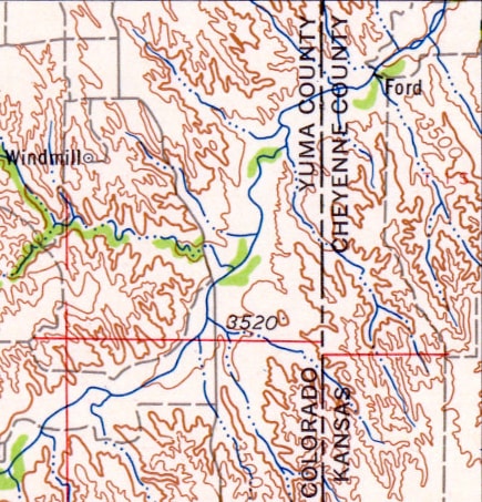
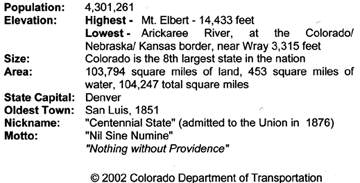
Arikaree River: the lowest elevation in Colorado
|
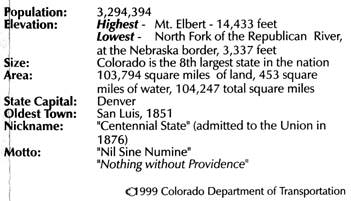
Despite an abundance of information to the contrary, the lowest point in Colorado is not where the Arkansas River flows out of the state (3,350 feet above sea level). Neither is it where the North Fork of the Republican exits (3,337 feet). No, the lowest point in the state of Colorado is 3,315 feet: where the Arikaree River flows into the northwest corner of Kansas.
|
|
1941: Beginning with this issue of their official state highway map, the Colorado Dept. of Transportation included information about Colorado's lowest point:

1963: This was the first issue of CDoT's state highway map on which the elevation was changed to 3350', but the location was still described as "near Holly".
|
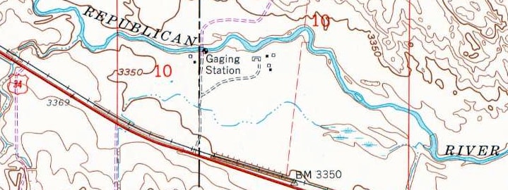
c. 1980s: In 2000 a USGS representative informed me that this was the timeframe during which they created their list of the lowest points in each state. For their research, they used the smaller-scale 1:250K map series, not the largest-scale 1:24K maps. (Perhaps that was because, at the time, there was not nationwide coverage at the 1:24K scale. Or maybe they thought it would be an unnecessary waste of time to look at so many 1:24k maps.) So, following are the portions of the 1:250k maps that show where the three Colorado rivers with the lowest elevations flow out of the state. Each of these maps have 100-foot contour intervals. We begin with the "Sterling" quad, illustrating where the North Fork of the Republican River flows into Nebraska. The thicker brown line is the 3500' contour, so, using this map, all one can say for certain is that the elevation of this river at the state line is "less than 3400 feet":
|

c. 1976
|
|
The point where the Arikaree River flows into Kansas is just to the south, on the adjacent "Limon" quad. Note that here, too, all one can be sure of is that the Arikaree is less than 3400 feet...
c. 1958
|
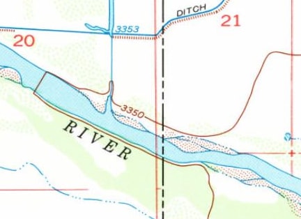
...but then compare this portion of the "Lamar" quad that shows where the Arkansas River flows out of the state. Notice that the cartography includes "supplemental" (dashed) contour lines for both 3450' and 3350'... which allows one to be certain that the Arkansas River is under 3350' where it exits the state:

c. 1958
So, based on the 1:250k map series, it is easy to see how someone might come to the conclusion that the Arkansas River has the lowest elevation at the state line. And that is the information that both USGS and CDoT publicized for several years.
|
|
c. 1995: CDoT's official state highway maps begin listing a different spot as Colorado's lowest: the point where the North Fork of the Republican River flows out of the state, at 3,337 feet. It is unknown how CDoT discovered that the Republican is lower than the Arkansas, but one possibility is this: there is a USGS stream gauge located where that river crosses the state line. Those gauges have published elevations, so it is possible that someone came across that figure and realized that it was lower than the Arkansas:
|
|
|
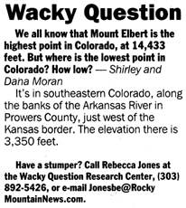
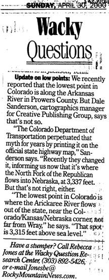
April 13, 2000: One of Denver's newspapers (the Rocky Mountain News, now defunct) printed a feature called "Wacky Questions", where readers could submit questions to the columnist, who was an expert at tracking down obscure information. On this date, someone wanted to know, "Where is the lowest point in Colorado?"
|
|
|
April 15, 2000: Because the CDoT map had been listing the North Fork Republican as the state's lowest point, I knew her answer was wrong. But, before I replied to the columnist with that information, I checked to see whether the Republican was indeed the low point. This was before USGS maps were available online, so I went to the library and used 1:24k maps to check all of the possibilities. The corresponding quads show that the Arkansas is actually at about 3347' where it flows out of Colorado...
|
c. 1953, "Holly East" quadrangle
|
|
...and the North Fork of the Republican is indeed about 3337'...
|
c. 1961, "Laird" quadrangle
|
|
...but the Arikaree River is clearly shown to flow out of Colorado between the 3310' and 3320' contours:
|
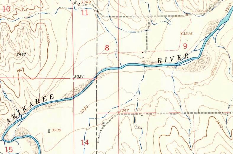
c. 1963, "Willow Creek Ranch" quadrangle
|
|
So I discovered that the Arikaree is lower at the state line than both the Arkansas and the Republican. I e-mailed a response to the columnist, and was pleased to find, a few weeks later, that she essentially reprinted my letter:
|
|
|
May 2, 2000: Jack Parsell, author of a book on lowest elevations, responded to the posts referenced above, and came to the same conclusion. Around this time, he also may have contacted USGS about their inaccuracy (see "October 2000", below).
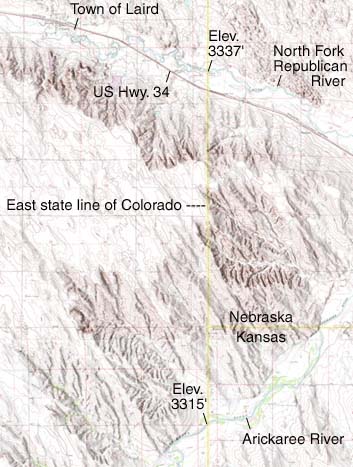
May 15, 2000: The "America's Basement" website becomes the first source to acknowledge the true lowest point in Colorado. (This material has since been absorbed by the excellent Highpointers Club website.) June 8, 2000: Adam Roddy went to find the newly-discovered lowest point in Colorado. Meanwhile, I finished my map of the area, and posted it on this website. A quick note on spelling: the river is "Arikaree", but the community is "Arickaree". I did not notice the difference initially, and when I was first making these pages, I was spelling the river with a "c". I have since corrected the text, but my map retains the incorrect spelling: |
Sanderson, 2000
|
August 2000: I finally became aware of the "America's Basement" site and the "U.S. and World Highpoints" forum. I corresponded with Roger Rowlett, who provided some of the information on this timeline.
September 2000: Ed Quillen published an article in Colorado Central Magazine about the "new" lowest point in Colorado, referencing my web pages. That article is archived here, but following is a copy of the html:
The Lowest Point isn't on the Arkansas, after allBrief by Central StaffColorado Geography - October 2000 - Colorado Central Magazine - No. 80 - Page 4Copyright © 2000 by Central Colorado Publishing Co. All rights reserved.Some of us who live along the Arkansas River have boasted that its drainage includes both the highest point in Colorado (14,433-foot Mt. Elbert in Lake County) and the lowest (3,350 feet, where the Arkansas crosses the Kansas line a few miles east of Lamar). It turns out that we were wrong. We were in good company, since that's what the U.S. Geological Survey has listed as Colorado's lowest point for as long as anyone can remember. It probably came about because someone theorized that the lowest point had to be where a major river (like the Arkansas, South Platte, Colorado, or Rio Grande) left the state, and upon checking those, the Arkansas turned out to have the lowest exit point. Enter Dale Sanderson, a cartographer for Qwest in Denver (small world, though; Colorado Central is produced in a Salida house that we bought from his uncle John in 1989). He noticed that the 1999-2000 official map from the Colorado Department of Transportation listed a new lowest Colorado point. The CDOT low point -- 3,337 feet -- is at the Colorado-Nebraska border, in Yuma County where the Republican River leaves the state east of Wray. Sanderson wondered how that had been missed for all the years, and also wondered if an even lower point might have escaped notice. So he delved into the USGS maps, and he found one, also in Yuma County. It's at 3,315 feet, where the Arickaree River flows into Kansas (Yuma County borders both Kansas and Nebraska; geographic trivia buffs might take note of Cimarron County in the Oklahoma panhandle, which holds the record for U.S. counties by bordering four states: Texas, Colorado, Kansas, and New Mexico). Both the Republican and the Arickaree rivers have their headwaters out on the plains, and neither is tributary to the Arkansas. The Arikaree just crosses the northwest corner of Kansas and joins the North Fork of the Republican in southen Nebraska. The North and South Forks unite about 30 miles east of that, and flow east, then south into the Kansas River, which joins the Missouri at Kansas City. So Colorado's real low point isn't on Arkansas River drainage, and we'll have to settle for having the three highest points in Colorado (Elbert, Massive, and Harvard) all on Arkansas drainage. We might also note that even though Colorado's lowest point has dropped by 35 feet, Colorado still has the highest low point of the 50 states. The runner-up is Wyoming, at 3,099 feet where the Belle Fourche flows into South Dakota -- or so says the USGS. |
July 24, 2001: I checked the USGS page on this day, and I found it had been updated with the new low point... well, sort of: they had the county and the elevation correct, but instead of "Arikaree River", it read simply "Alikaree". I e-mailed a correction and received a reply that it would be fixed.
August 6, 2001: The USGS page was corrected to list "Arikaree River" as the lowest point in Colorado. Over the next year, I contacted several government organizations and webmasters, asking them to correct their info.
|
May 2002: This was the first issue of CDoT's state highway map to list the Arikaree as the state low point. Note the similarity to my letter to the editor (above), including the misspelling of "Arickaree":
|
|
|
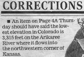
September 2003: It is hard to kill misinformation, and once it is published on the web it seems to spread exceptionally fast. And apparently newspaper writers sometimes opt to do a quick web search rather than researching their own archives:
|

|
After reading that, I e-mailed the editor for that page, and the next day a correction was printed:
|
|
|
September 10, 2005: up until then, the Wikipedia page "List of US States by Elevation" listed the incorrect Colorado lowpoint, but on this date it was corrected, and my webpage was cited as the source.
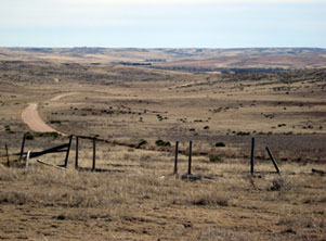
February 2009: Scott Smith visited the site and took some photos. This first one was taken from County Road RR south of Laird, looking south and a little east: |
Smith, Feb. 2009
|
|
That gives a good feel for what this part of the country looks like in general: virtually no trees, except along the creekbeds. In the distance, a darker area is visible: those are trees lining the valley of the Arikaree River. Beyond that are the Arikaree Breaks in the northwest corner of Kansas (this is the same road that provides access to the tri-state corner of Colorado, Kansas, and Nebraska). Travelers can drive pretty much right up to that point, but there is no public access to the lowest point in Colorado.
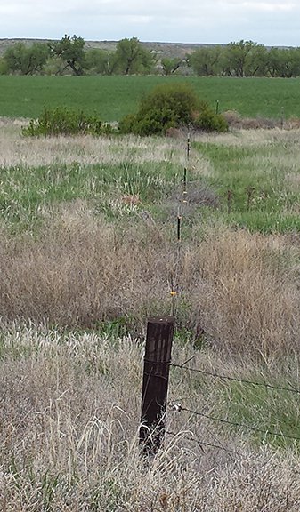
May 2015: Ron Michaels visited the area. This photo was taken looking due south along the CO-KS stateline: |
Michaels, May 2015
|
|
The fenceline in the middleground runs along the state border, so if you visually extend that line to the riverbed in the background (marked by the cottonwood trees), that is the Colorado lowpoint, where the Arikaree flows out of the state. The following shots show what the river looks like in that area; these first two were taken at the stateline looking downstream (northeast):
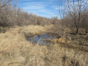
Smith, Feb. 2009
March 2019: David Alexander visited the area. These photos illustrate the fact that water in the Arikaree valley does not always flow on the surface; there are many segments where the surface is dry while the water flows underground:
|
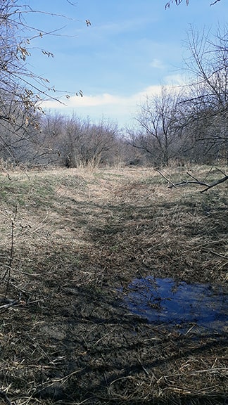
Alexander, Mar. 2019
|
|
This photo was also taken from the stateline, but looking in the upstream direction (southwest):
|
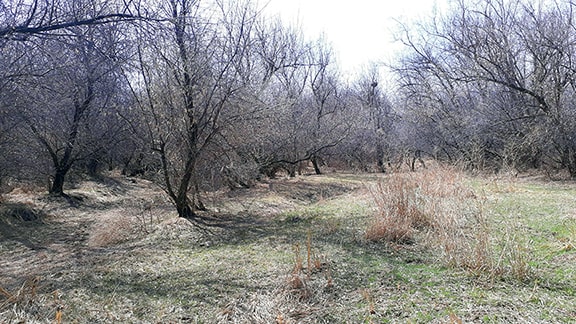
Alexander, Mar. 2019
|
But what is perhaps even more remarkable is the fact that the Arikaree manages to get down to this elevation by the time it exits Colorado... because if one follows the Arikaree upstream, its source is located a few miles northwest of Limon, at an approximate elevation of 5900 feet. This land forms the western edge of a "table" that is tilted ever-so-slightly to the east. This table sits about 500 feet above both Big Sandy Creek (a tributary of the Arkansas) and Bijou Creek (a tributary of the South Platte). So, how does the Arikaree manage not only to make up that 500 feet, but also to get to an even lower elevation than both of those rivers by the time it reaches the stateline, which is only about 100 miles to the east? Does it pass through land that is perhaps more subject to erosion? That seems like a possibility when one considers that this lowpoint is in an area known as the Arikaree Breaks: a small, scenic region with canyon-like characteristics that can come as a surprise to people passing through here who were not expecting anything other than the level land typical of most high plains locations.
last updated Mar. 27, 2019.
