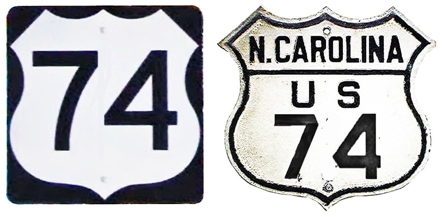
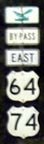
End of US highway 74 |
 |
|
1926-1934
|
1934-1938
|
1938-1986
|
1986-1994
|
1994-present
|
Summa
|
Mileage: in 1989 AASHTO listed a figure of 577 miles for US 74... however, that included the mileage of US 74's associated business routes. According to the state subtotals on AASHTO's 1989 spreadsheet, mainline US 74's actual end-to-end total was 524 miles. As of 2020, the signposted portion of US 74 (to Cleveland TN) measured 496.9 miles. The distance between defined endpoints (including the 19.1-mile unsigned segment between Cleveland and Chattanooga) was 516.0 miles.
|
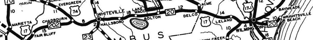
The east end of US 74 was originally at Chadbourn:
c. 1930, NCDoT
|
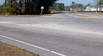
This photo shows the spot, looking south on Old Highway 74. Running across the photo is US 76. But originally it was southbound US 17 to the right. Northbound was straight ahead on Strawberry Boulevard (which immediately curves to the left towards downtown Chadbourn). US 74 ended here at its junction with US 17:
|

Watkins, Jan. 2008
|
|
Here, we are looking the opposite direction (north on Strawberry). This would have been southbound US 17, which turned to the left on today's US 76. Straight ahead was the east beginning of US 74 (modern US 76 to the right did not exist at the time):
|
Watkins, Jan. 2008
|
|
In 1934 US 74 was extended to Wilmington, and then by 1938 US 74 was extended out of Wilmington to Wrightsville Beach, where it initially shared a common terminus with US 76 (more info and photos on the Wrightsville page).
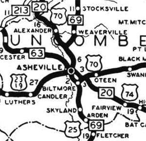
For the first 60 years of its existence, the west end of US 74 was in Asheville: |
c. 1930, NCDoT
|
|
Originally US 74 came in on Old Charlotte Highway, becoming Fairview Road, which connected with today's Brook and Lodge streets. The designation ended at its junction with US 25, which ran along Biltmore Avenue at the time. This photo was taken looking north on Biltmore:
|
Stanton, July 2008
|
|
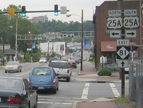
Today US 25A crosses there on Lodge, and ends one block to the left (at mainline 25 on McDowell Street). But originally that was northbound US 25, and US 74 began to the right. It was 1933 when US 25 traffic was shifted over to McDowell, and that same year US 74 traffic was redirected as well. From Charlotte Hwy, US 74 used Swannanoa River Road, then went through the Beaucatcher Tunnel, and ended up on College Street. The designation continued to end at its junction with US 25:
|
Karners, Apr. 2014
|
|
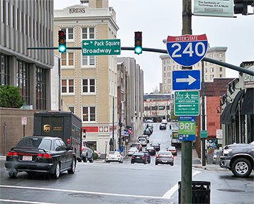
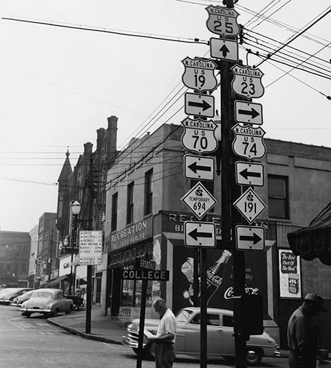
That was looking west on College; US 74 ended there at Broadway (US 25). Today there is an interchange with I-240 about a quarter-mile to the north (right). Both of these next photos were taken looking south on Broadway; US 74 began to the left on College:
Stanton, July 2008
|
c. 1950, National Archives Catalog (linked to source)
|
|
That was the situation until around 1955. The photo below shows the third (and last) Asheville terminus:
|
Karners, Apr. 2014
|
That was looking south on Tunnel Road, or US 70, which curves to the left. For about 30 years US 74 began by splitting off straight ahead (along what is now a sidewalk). The road configurations have since changed a bit, and the historic alignment has been vacated. But if one were to follow that alignment, they would run right into South Tunnel Road (which is now designated Alternate US 74). Behind the camera about a mile is the Beaucatcher Tunnel, from which these roads get their name.
Until the 1980s, US 64 was the only east-west route that spanned the entire width of North Carolina. But US 64 is not a heavily-traveled route, particularly in the western part of the state. To the north of US 64, a corridor to Asheville was gradually being upgraded to four lanes. However, travel along that corridor between Asheville and I-75 (in Tennessee) involved five different designations (US 64, US 19, US 441, US 23, and I-40). Note that the majority of those were north-south routes, so it makes sense that NCDoT would want to unify that corridor under a single east-west designation. Perhaps that is what motivated the changes that took place in the latter part of the decade.
Until the 1980s, US 64 was the only east-west route that spanned the entire width of North Carolina. But US 64 is not a heavily-traveled route, particularly in the western part of the state. To the north of US 64, a corridor to Asheville was gradually being upgraded to four lanes. However, travel along that corridor between Asheville and I-75 (in Tennessee) involved five different designations (US 64, US 19, US 441, US 23, and I-40). Note that the majority of those were north-south routes, so it makes sense that NCDoT would want to unify that corridor under a single east-west designation. Perhaps that is what motivated the changes that took place in the latter part of the decade.
|
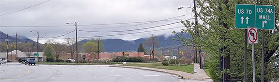
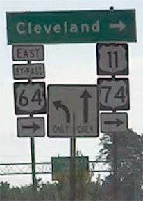
In a 1986 meeting, AASHTO approved an extension of the west end of US 74 from Asheville, explicitly to the junction with I-24 in Chattanooga... officially, that is. But since 1994, US 74 signage ends in Cleveland, well short of Chattanooga. The last westbound sign is posted on the US 64 bypass, just west of the US 11 interchange:
|
Sanderson, Aug. 2018
|
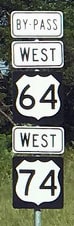
Continuing west on US 74, there is no "End" signage, but there are no more references to US 74, so the signed portion of US 74 ends at its junction with I-75:
|
Bermudez, July 2006
|
Sanderson, Aug. 2018
|
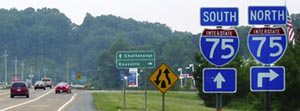
That is the apparent end of US 74. But TN DoT maps indicate that US 74 still runs concurrently with I-75 about 19 miles to the left (southwest) from there, ending in Chattanooga at exit 2 (which is the same interchange where I-24 begins):
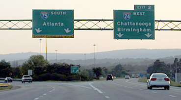
Cozart/Nitzman, Aug. 2003
|
|
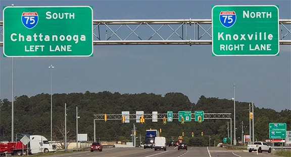
That is the official west end of US 74. Heading north on I-75 or east on I-24, the west beginning of US 74 is to the north with northbound I-75, but there is no reference to US 74 on signage in the area:
|
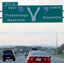
Cozart/Nitzman, Aug. 2003
|
Sanderson, Aug. 2018
|
|
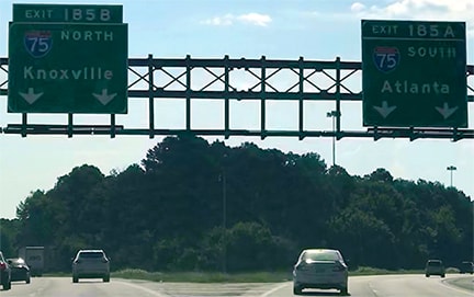
In fact, US 74 is not even signed where it splits off from I-75 at exit 20 in Cleveland...
|

Cozart/Nitzman, Aug. 2003 (unchanged as of 2018)
|
|
So the signed west beginning of US 74 is in Cleveland.
|

Research and/or photo credits: Andrew Bermudez; Justin Cozart; Karin and Martin Karner; Alex Nitzman; Mike Roberson; Dale Sanderson; Francis Stanton; Michael Summa; Mac Watkins
Page originally created 2000;
last updated Dec. 17, 2023.
last updated Dec. 17, 2023.
