Historic US highway endpoints in Milwaukee, WI
|
1927-1989
|
 |
|
At the time the US routes were commissioned in 1926, two of them had termini in Milwaukee: US 18 and US 141. Sources for this page include:
|
However, more information is needed for a complete picture. I am interested in seeing anything that might shed light on the historic routes of US 18 and US 141 in Milwaukee:
|
|
For the first couple years, US 18 traffic heading east from Waukesha was directed along Arcadian Avenue/Greenfield Avenue, and then National Avenue, to somewhere in downtown Milwaukee. At least one map illustrating Milwaukee's nascent US highway system showed US 18 staying on National all the way to 1st Street, or maybe even a couple blocks beyond...
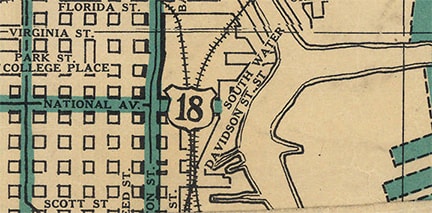
c. 1927, Milwaukee Journal
|
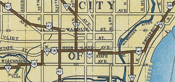
...however, a map published the same year by a presumably more reliable source showed US 18 on National only as far east as 27th Street (labeled "Kilbourn"), where it turned north and joined US 16 at Highland Avenue (labeled "Prairie"):
c. 1927, Wisconsin DoT
|
|
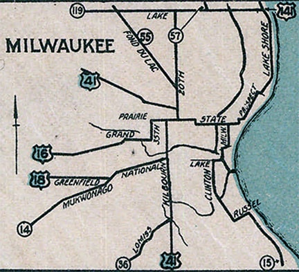
Also, the very next year's issue of the Milwaukee Journal map no longer showed US 18 on National. So one may well conclude that the Journal's 1927 map was in error, and that US 18 actually joined with US 16, following Highland and State Street into the downtown area. In fact, the next issue of the DoT map showed that US 16 and US 18 were twinned well to the west of the city:
|
c. 1928, Wisconsin DoT
|
Whereas those DoT maps do seem to disprove the idea that US 18 ended on National, they are not at all explicit about where US 18 actually did end... nor about where US 141 ended. We can draw some conclusions from later maps, and we can also do some speculating, but I am not aware of any maps from the late 1920s or early 1930s that conclusively answer the question.
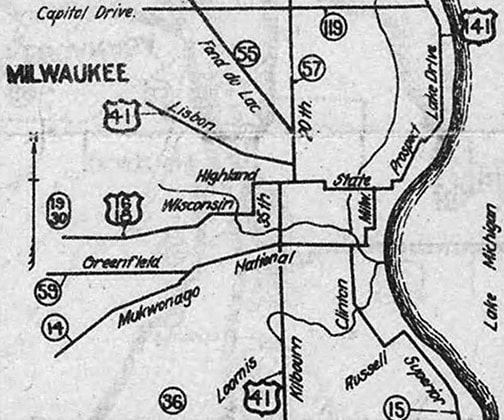
As far as US 141's endpoint, it is worth keeping in mind that the US 141 designation was originally set up as a shortcut, or alternate route, for US 41 traffic between Milwaukee and Green Bay. Therefore, it makes sense that US 141 would have had to connect with its parent route. US 41 skirted the edge of the downtown area via 27th. But as shown on the preceding map, originally 27th did not go all the way north to Lisbon Avenue. Instead, connecting traffic was directed to use Highland and 20th. |
|
Meanwhile, US 141 came into Milwaukee from the north via today's WI 32 (formerly WI 42) on Prospect Avenue, turning west onto State. At Milwaukee Street, WI 42 turned southward, but in order to connect with US 41, US 141 would have continued west to 10th, where it jogged north for one block before resuming westward on Highland. The US 141 designation ended at 20th Street, where northbound US 41 was to the north, and southbound was straight ahead (west on Highland):
|
Enslin, 2001
|

(detail)
|

(detail)
|
|
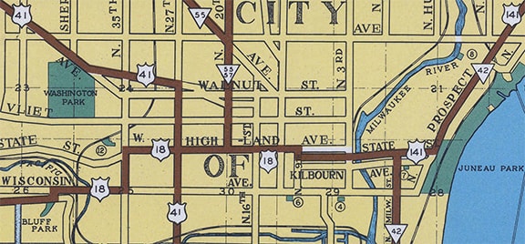
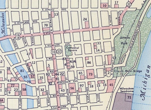
In 1930, US 16 was removed from downtown Milwaukee, instead running across the north side via Capitol Drive. In 1935, the jog in US 41 (via Highland and 20th) was removed; instead traffic was directed to use 27th straight through its intersection with Highland. That is the arrangement depicted on this map, which also supports the notion that US 141 did not end in the downtown area, but rather extended west to a junction with US 41:
c. 1936, Milwaukee Co. Highway Dept.
|
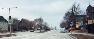
This photo was taken looking west on Highland at 27th. This intersection marked the south end of US 141 after 1935:
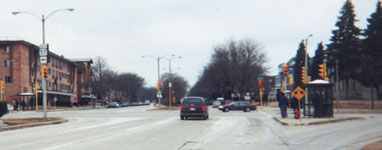
Enslin, 2001
US 41 ran across that photo, and westbound US 18 was straight ahead. In fact, the preceding map suggests that straight ahead was the east beginning of US 18, but was that really the case?
|
|
East of Waukesha, US 18 essentially ran along today's corridor (Moreland Boulevard/Bluemound Road/Wisconsin Avenue). In the downtown area, traffic was directed north a few blocks to Highland, where it resumed eastward. US 18 junctioned US 41 at 27th, where it could have ended. But consider that, especially during the early years, it was a common practice to sign routes to a central location in the destination city, even if that meant overlapping with other routes. So it is likely that US 18 continued west from 27th, dual-signed with US 141, ending at a location in the downtown area. That idea is supported by multiple maps, including this later edition of the preceding map:
|
c. 1946, Milwaukee Co. Highway Dept.
|
|
This commercial map from the following year also showed a US 18 marker east of US 41:
|
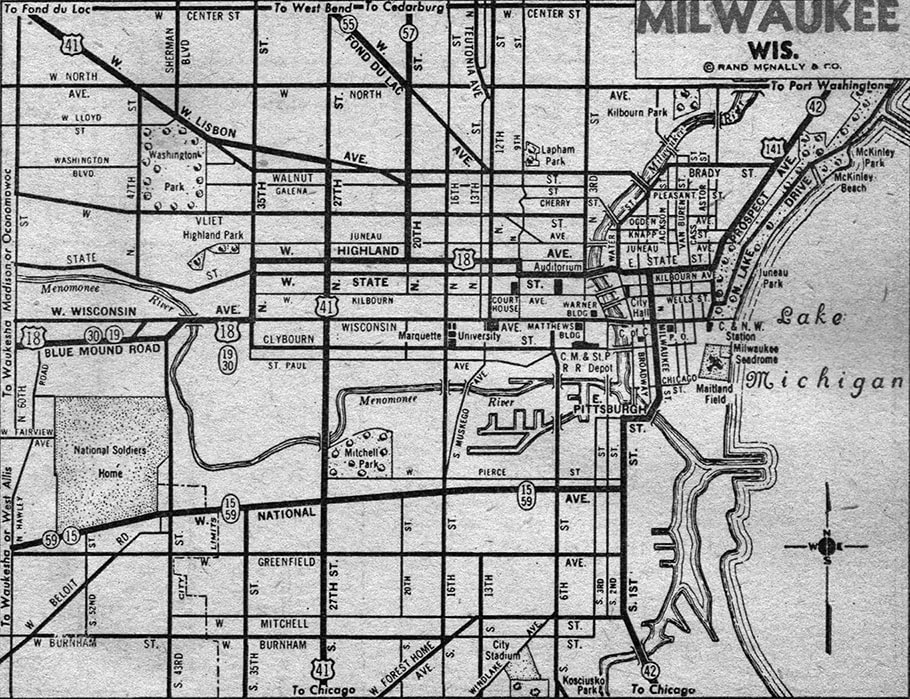
c. 1947, Rand McNally
|
|
But where exactly did US 18 end? We will come back to that, but first it should be noted that was the last map to show US 141 coming in on Prospect: in 1947 it was changed to go south on Port Washington Avenue, Capitol Drive west, and then 20th Street south to Highland (US 18). It could have ended there, but was possibly dual-signed west with US 18 to 27th, in order to maintain a connection with US 41. Either way, US 141 terminated at one of its previous endpoints, although it approached from a different direction. Regardless, that lasted only a few years, because in about 1950, US 141 was truncated such that it ended on Pt. Washington at Capitol:
|

Enslin, 2001
|
|
By the time of this next map, an additional change had taken place: US 16 traffic had been redirected back into the downtown area. Also, US 18 was clearly shown ending on State at Milwaukee Street, where WI 32 traffic made a turn. In my opinion, it is likely that this was the same intersection where US 18 had ended since the late 1920s:
|
c. 1956, Gousha
|
|
This photo was taken looking north on Milwaukee at State. Currently this is the perspective of a driver on westbound US 18, and traffic is directed to turn left (west) on State. However, at the time of the map shown above, it was US 16 traffic which made a turn at this intersection, and to the left on State was also the west beginning of US 18:
|
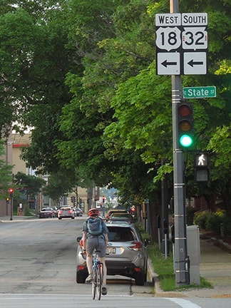
Sanderson, Jun. 2022
|
|
From the area shown on that map, US 16 continued south on Milwaukee, then southeast on Erie Street, connecting with the ferry that carried it across Lake Michigan to Muskegon MI, as shown on these maps:
|
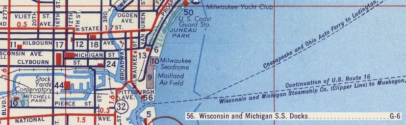
c. 1956, Gousha
|
c. 1959, Gousha
|
|
Here is an historic photo from that location, back when US 16 traffic was directed to the ferry landing:
|
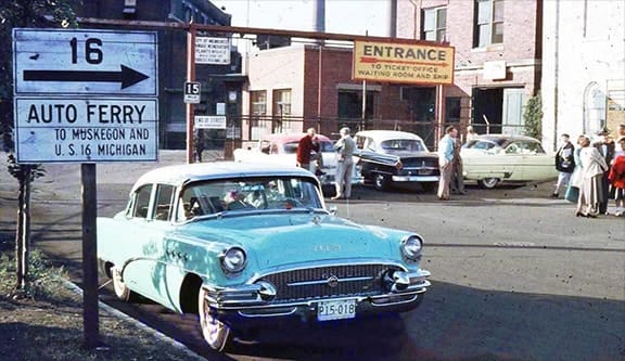
attribution unknown; reportedly dated 1956
|
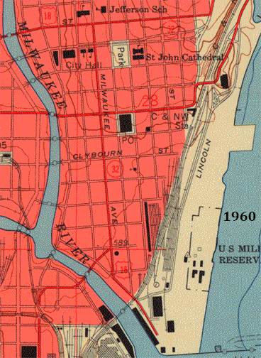
USGS
|
That US 16 routing was corroborated on the 1960 USGS quad, but the 1988 revision showed that US 16 had been truncated, and that US 18 had been extended to end at the ferry dock. Today there is not much left of the old ferry landing, but the City had a nice little park built in the same approximate location (Erie Street Plaza):
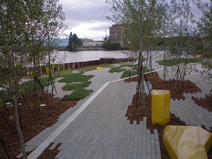
Reid, Jun. 2010 (linked to original)
|
|
Here is another view of the former ferry landing, looking across from the other side of Milwaukee's harbor:
|
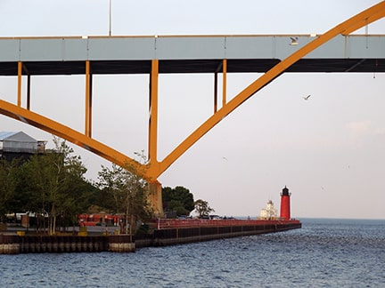
Sanderson, Jun. 2022
|
|
That change actually took place in 1963, which is when US 16 was truncated to Waukesha. But apparently Wisconsin thought the ferry should still be served by a US route, so the US 18 designation was extended to US 16's former terminus. That US 18 endpoint was also shown on this map (along with a bonus "Alternate US 18" route):
|
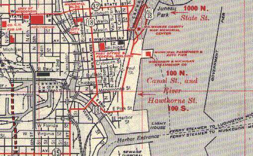
c. 1967
|
|
Meanwhile, the south end of US 141 was in constant flux: today's I-43 to the north of Milwaukee was completed in stages from north to south, and it was initially signed as US 141. In 1963 US 141's terminus was shifted a few blocks east of its previous endpoint (on Port Washington at Capitol), such that it ended on what is now I-43 at Capitol Drive. Over the next few years, the North-South Freeway was extended south incrementally, until in 1969 it reached the Marquette interchange downtown:
|

Morrison, May 2010
|
Research and/or photo credits: Chris Bessert; Nathan Edgars; Jon Enslin; Jeff Morrison; Dave Reid; Dale Sanderson
Page originally created 2001;
last updated Jun. 8, 2022.
last updated Jun. 8, 2022.
