US Ends .com
  • Home
  • Store
    • US highway map
    • Florida US highway map
  • Endpoints
    • US 1 - US 9 >
      • 1 >
        • 201
        • 301
        • 401 [i]
        • 401 [ii]
        • 401
        • 501
        • 601
        • 701
      • 2w >
        • 102
      • 2e >
        • 202
        • 302
      • 3
      • 4 >
        • 104
      • 5
      • 6 >
        • 106
        • 206
      • 7
      • 8
      • 9 >
        • 109*
        • 209
        • 309
    • US 10 - US 19 >
      • 10 >
        • 110
        • 210
        • 310
        • 410
      • 11 >
        • 111
        • 211
        • 311
        • 411 [i]
        • 411 [ii]
        • 411
        • 511*
        • 611
        • 711*
      • 12 >
        • 112
        • 212
        • 312
      • 13 >
        • 113
        • 213
      • 14
      • 15
      • 16 >
        • 116
        • 216
      • 17 >
        • 17-1
        • 117 [i]
        • 117
        • 217
      • 18 >
        • 118
        • 218
      • 19 >
        • 119
        • 219
        • 319
    • US 20 - US 29 >
      • 20e >
        • 120
        • 220
        • 320
        • 420
      • 20w
      • 21 >
        • 121 [i]
        • 121
        • 221
        • 321
        • 421
        • 521
      • 22 >
        • 122 [i]
        • 122 [ii]
        • 222
        • 322
        • 422e
        • 422w
        • 522
        • 622*
      • 23 >
        • 123 [i]
        • 123
        • 223
      • 24 >
        • 124
        • 224
      • 25
      • 26 >
        • 126
      • 27 >
        • 127
        • 227
      • 28
      • 29 >
        • 129
    • US 30 - US 39 >
      • 30 >
        • 130
        • 230
        • 330
        • 430
        • 530
        • 630*
        • 730
        • 830
      • 31 >
        • 131
        • 231
        • 331 [i]
        • 331
        • 431
      • 32
      • 33
      • 34
      • 35
      • 36 >
        • 136
      • 38 >
        • 138
    • US 40 - US 49 >
      • 40 >
        • 140
        • 240
        • 340
      • 41 >
        • 141
        • 241 [i]
        • 241 [ii]
        • 341
        • 441 >
          • 441n
          • 441s
        • 541
        • 641
      • 42
      • 43
      • 44
      • 45
      • 46
      • 48 [i]
      • 48 [ii]
      • 48
      • 49
    • US 50 - US 59 >
      • 50 >
        • 150
        • 250
        • 350
        • 450
        • 550
        • 650
      • 51 - 55 >
        • 51 >
          • 151
        • 52 >
          • 152
        • 53
        • 54 >
          • 154
        • 55
      • 56 >
        • 156
      • 57
      • 58 >
        • 158
        • 258
      • 59 >
        • 159
        • 259
    • US 60 - US 69 >
      • 60 >
        • 160
        • 260
        • 360
        • 460
      • 61 - 65 >
        • 61 >
          • 161
        • 62
        • 63 >
          • 163 [i]
        • 64 >
          • 164 [i]
          • 164 [ii]
          • 264
        • 65 >
          • 165
      • 66 >
        • 166
        • 266
        • 366 [i]
        • 366 [ii]
        • 466
        • 566
        • 666
      • 67 >
        • 167
      • 68 >
        • 168
      • 69 >
        • 169
    • US 70 - US 79 >
      • 70 >
        • 170
        • 270 [i]*
        • 270
        • 370
        • 470
      • 71 >
        • 171
        • 271
        • 371 [i]
        • 371
      • 72 - 76 >
        • 72
        • 73
        • 74
        • 75 >
          • 175
          • 275
        • 76 >
          • 176
          • 276
      • 77 >
        • 177
        • 277
        • 377
      • 78 >
        • 178
        • 278
        • 378
      • 79
    • US 80 - US 89 >
      • 80 - 84 >
        • 80 >
          • 180 [i]
          • 180
          • 280
          • 380
        • 81 >
          • 181
          • 281
        • 82
        • 83 >
          • 183
          • 283
          • 383
        • 84
      • 85 - 89 >
        • 85 >
          • 185
          • 285 [i]
          • 285
          • 385 [i]
          • 385
          • 485
        • 87 >
          • 187
          • 287n
          • 287s
        • 89n
        • 89s >
          • 189 [i]
          • 189
    • US 90 - US 99 >
      • 90 - 94 >
        • 90 >
          • 190
          • 290
        • 91 >
          • 191 >
            • 191n
            • 191s
          • 491
        • 92 >
          • 192
        • 93
        • 94
      • 95 -98 >
        • 95 >
          • 195
          • 295
          • 395
        • 96 [i]
        • 96
        • 97 >
          • 197
        • 98
      • 99 >
        • 199
        • 299
        • 399
    • Anomalies >
      • 101
      • 163
      • 400
      • 412
      • 425
  • Places
    • A-L >
      • A >
        • Aberdeen
        • Albuquerque
        • Amarillo
        • Apalachicola
        • Astoria
        • Atlantic
      • B >
        • Baltimore
        • Baton Rouge
        • Bay Area
        • Bishop
        • Boone
        • Brady
        • Bristol
        • Brownsville
        • Brunswick
      • C >
        • Charleston
        • Chattanooga
        • Chicago
        • Cincinnati
        • Cleveland
        • Cody
        • Corpus
        • Cortez
        • Council Bluffs
        • Covington
        • Crescent
        • Cumberland Gap
      • D-E >
        • Dallas
        • Des Moines
        • Detroit
        • Dothan
        • Douglas
        • El Paso
        • Eugene
        • Erie
      • F >
        • Farmington
        • Flagstaff
        • Florence
        • Fox Valley
        • Franklin
      • G >
        • Gallup
        • Grand Junction
        • Grand Portage
        • Grayling
        • Great Falls
        • Greeley
      • H-I >
        • Hardeeville
        • Harrisburg
        • Holbrook
        • Idaho Falls
        • Int'l Falls
      • J-K >
        • Jacksonville
        • Joplin
        • Junction
        • Kansas City
        • Keokuk
        • Key West
        • Kingman
      • L >
        • Laredo
        • Lewiston
        • Long Beach
        • Los Angeles
        • Louisville
        • Lubbock
    • M-R >
      • M >
        • Mackinaw
        • Madison
        • Maryhill
        • Maysville
        • Miami
        • Midway
        • Miles City
        • Milford
        • Milwaukee
        • Minneapolis
        • Mobile 31
        • Mobile 31-43-45
        • Montgomery
        • Monticello
        • Mount Vernon
      • N-O >
        • Nags Head
        • Naples
        • Natchez
        • New Castle
        • New Orleans
        • Niagara
        • Norlina
        • Ocean City
        • Oklahoma City
      • P >
        • Pee Dee
        • Pembina
        • Pensacola
        • Petersburg
        • Philadelphia
        • Piegan
        • Pineville
        • Port Arthur
        • Portsmouth
      • Q-R >
        • Quad Cities
        • Rapid City
        • Raton
        • Reading
        • Richmond
        • Rockingham
        • Rouses Point
    • S-Z >
      • S >
        • San Antonio
        • San Antonio NM
        • San Diego
        • Santa Fe
        • Savannah
        • Sioux
        • Springer
        • Springfield
        • St. Ignace
        • St. John
        • St. Paul
        • St. Pete
      • T-U-V >
        • Tallahassee
        • Tampa
        • Toledo
        • Trinidad
        • Ucolo
        • VA Beach
      • W >
        • Walterboro
        • Waverly
        • West Memphis
        • Wilmington
        • Wilson
        • Wrightsville
      • Y >
        • Yellowstone E
        • Yellowstone N
        • Yellowstone NE
        • Yellowstone S
        • Yellowstone W
  • Highways
    • Map of all endpoints
    • Sources
    • History
    • 1926 almost-routes
    • Intra-state routes
    • Numbering
    • Colors
    • Gaps
    • Blog
  • Bonus
    • Colorado >
      • Lowest point
      • Antipodes
      • Toponymy >
        • Roots
      • Colloquialisms
      • Populations
      • Denvers
    • Washington Meridian
    • Watersheds >
      • Headwaters Hill
      • Three Waters Mtn.
      • Parting of the Waters
    • Geo-centers >
      • 48 states
      • 50 states
      • North America
    • State corners >
      • AZ-CO-NM-UT
      • CO-UT-WY
      • CO-NE-WY
      • CO northeast
      • CO-KS-NE
      • CO-KS-OK
      • CO-NM-OK
      • NM-OK-TX
      • NM southeast
      • TX northwest
    • ooss.space
  • Connect
    • Author/history
    • Rationale
    • Contact
    • Contributors
    • Submissions

History

Phases in the history of the US route system

Get your very own map showing all current and historic US routes!

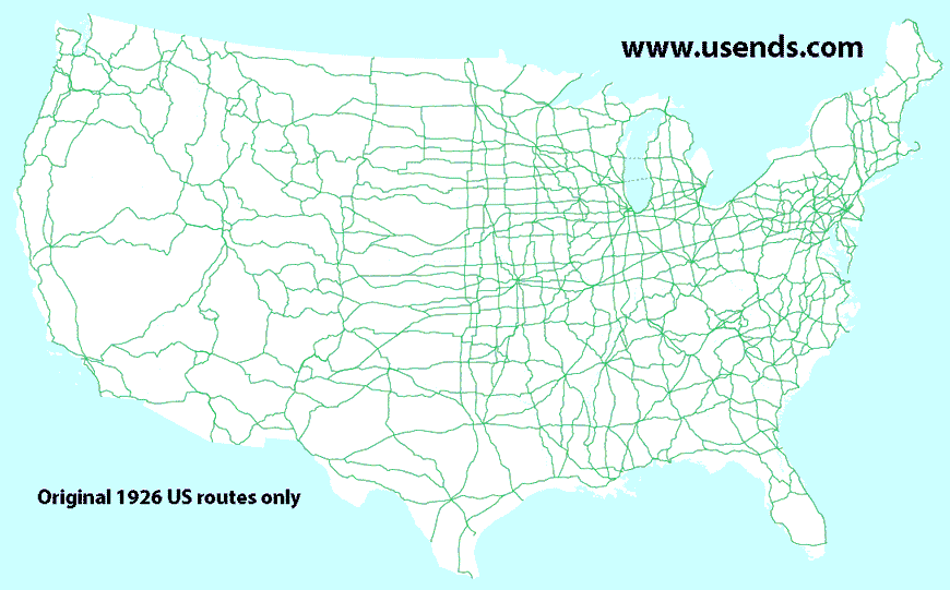
Most US routes were commissioned in late 1926, but some were not created until later.  And while some highways have existed continuously ever since 1926, others have come and gone in just a few short years.  For quite some time I wondered how it would look to graph all of the US highways on a timeline, and when I finally had an opportunity to create one, I was surprised about some of the patterns that showed up in the data.  Below I share the data along with some conclusions; please contact me if the following charts reveal anything to you.

Methodology

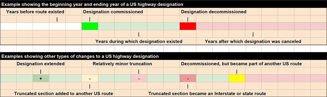
The colors and symbolization used on the timeline are as follows:
  • Each cell represents one year, starting on the left with 1926, and moving forward in time to the right.
  • White (or no color): the years before a particular US route existed. 
  • Bright green: the year a US route was commissioned. 
  • Pale green: the subsequent years during which the route existed. 
  • Bright yellow: the year a route was decommissioned (if the route became part of a different US highway).
  • Bright red: the year a route was decommissioned (for any other reason). 
  • Light red: the years after a route was decommissioned. 
Picture
​Route extensions and truncations were handled in the following manner:
  • Medium green with a + (plus) symbol: years in which route extensions took place. 
  • Light yellow with a - (minus) symbol: the route was shortened, but the truncated segment was added to a different US route. 
  • Light red with a - (minus) symbol: relatively minor truncations. 
  • Medium red with a - (minus) symbol: route was truncated either because it was replaced with a state route designation, or else because its functionality had been replaced by an Interstate highway.

Using this methodology, each of the nearly 300 current and historic US routes were added to the timeline.  The chart was then sorted numerically by route number (with US 1 at the top and US 830 at the bottom).  A horizontal black line was placed about one-third of the way down, dividing the "main" routes (1- and 2-digit numbers) from the "branch" routes (3-digit numbers).  The resulting chart reveals some interesting groupings in the data.  This first image is only a low-resolution overview of the entire chart...
Picture
...yet despite the high level of granularity in that timeline, we can still recognize some patterns:
  • Lots of bright green years in the far left column.  That is because the majority of US routes were commissioned the same year: 1926.
  • White horizontal lines along the left edge indicate routes that were not commissioned until sometime after 1926.
  • Light red horizontal lines along the right edge represent all of the routes that have been decommissioned.  It is clear from this chart that very few 1- and 2-digit US routes have been canceled, whereas a far greater percentage of 3-digit routes have been decommissioned.

​Based on the more detailed data in that chart (which can be viewed using the links below), the timeline was divided into four vertical columns, representing four distinct phases in the history of the US route system.  These time periods are referred to as follows:
The Refinement Years (1926-1941) 
  • [chart for "main" routes]  
  • [chart for "branch" routes]
The Golden Age (1942-1960)  
  • [chart for "main" routes]  
  • [chart for "branch" routes]
The Years of Decline (1961-1993)  
  • [chart for "main" routes]  
  • [chart for "branch" routes]
The Marginal Years (1994-present)  
  • [chart for "main" routes]  
  • [chart for "branch" routes]

The Refinement Years

These charts show the years 1926-1941 in greater detail: 
  • [chart for "main" routes]  
  • [chart for "branch" routes]
Although the inaugural map showing approved US routes was released in November 1926, that list was by no means "final".  Rather, within literally the first weeks and months after that route log was published, various state highway departments were already requesting changes.  And changes continued taking place at a rapid rate over the next 15 years, right up until the U.S. became involved in World War II.  ​
Picture
The Refinement Years were characterized by the following:
  • Several new two-digit US route designations.  Not all two-digit numbers were assigned to routes in 1926; 18 numbers were left available for future additions to the system.  Five of those 18 have never been used (37, 39, 47, 86, 88).  But out of the remaining 13 numbers, 11 were assigned during the Refinement Years (33, 35, 43, 44, 46, 58, 59, 62, 79, 82, 98).  Only two other 2-digit numbers would be assigned in later years (56 and 57).
  • Several new three-digit US route designations.  60 additional three-digit branch routes were assigned during the 15-year period following 1926.
  • Many US route extensions.
  • Decommissionings of various US route designations.  In 1937 AASHO released a document which included the statement: "US routes, less than 300 miles in length, heretofore established and located wholly in one state, shall be eliminated either by consolidation with other US routes or by reverting to state routes..." [reference]  Several routes were deleted during the Refinement Years, many probably in response to that document.  42 designations were retired because their routes were appended to other, longer US highways.  And ten additional routes were eliminated and replaced by state route designations.  Of those ten, nine were short intra-state routes.
  • Some US route truncations, but again, the majority of these shortened segments were simply transferred to other US routes.
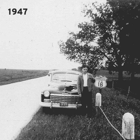
Scheduled airline service would not begin until the late 1950s, and the cost of airfare remained out of reach for most people through the 1960s or '70s.  However, automobile travel had started to become more affordable decades earlier, especially after WWII.  Bridging the Refinement Years and the Golden Age, there was a period (from roughly the 1930s through the '50s) during which the US route shield was a symbol of status for people who had the means and enough leisure time to drive their car across the country.  It was quite common for vacationers to document their journey by pulling over and posing for photographs along with a US route signpost:

The Golden Age

These charts show the years 1942-1960 in greater detail:
  • [chart for "main" routes]  
  • [chart for "branch" routes]
Since Pearl Harbor was attacked in Dec. 1941, one could easily conclude that the reason why US highway-related activity dropped off sharply in 1942 was because so much attention had been diverted to the war effort.  Undoubtedly that was a factor, but if WWII were the only reason for the dropoff, then one would expect activity to increase again after the war ended in 1945.  Yet that did not happen, so there must have been additional influences.  I believe another contributing factor was the aforementioned document that AASHO released in 1937.  With respect to US routes, the state highway departments were now operating under new lines of thought, such as "the U.S. numbering system needs perfecting rather than expansion", and "additional routes for U.S. numbering will be greatly limited" [reference].  These new guidelines ushered in what I consider to be the "Golden Age" of the US highway system.  During these two decades, the US routes were still the nation's elite, primary highways, carrying the bulk of interstate traffic, and they did not yet face competition from the modern Interstate Highway System.  The Golden Age was characterized by the following:
  • ​A decline in the amount of new US routes.  Only 16 new routes were commissioned during the Golden Age (compared to more than 70 during the preceding Refinement Years).
  • A decline in the amount of changes to existing US routes.  But the changes that did take place consisted almost entirely of extensions (rather than truncations).
  • A decline in the amount of US route eliminations.  During the Golden Age, only five routes were decommissioned (compared to 52 during the Refinement Years).  In all five of those cases, their mileages were simply transferred to other US routes.
Today in most states, the standard US highway shield includes only the route number.  But historically the standard shield also included "U.S." and the state name.  The person shown in the following photos took several vacations by car during the late 1940s and early '50s.  He used US highway shields for his photographic record, documenting his first visit to each state.  He was probably from somewhere in the northeast part of the country, because the states without photos are all in the south and west:
Picture

The Years of Decline

These charts show the years 1961-1993 in greater detail:
  • [chart for "main" routes]  
  • [chart for "branch" routes]
In 1956 the Federal Aid Highway Act was passed, and this paved the way for construction to begin on the nation's Interstate Highway System.  In most cases, the Interstates were built along essentially the same corridors as the most heavily-traveled US routes.  In fact, some of the limited-access roads that eventually became segments in the Interstate system were constructed years earlier as improvements to existing US highways.  But when an Interstate was completed and opened to traffic, any parallel US routes became redundant, and in some cases, irrelevant.  The Years of Decline were characterized by the following:
  • ​​General loss of favor.  Three decades earlier, during the Refinement Years, proposed US highway alignments were challenged by people whose cities would not be located on the route in question, and defended by others who did not want the route to be moved away from their area [reference].  During the Golden Age, officials in towns that had been left out of the US highway system strove to have highways through their area recognized as US routes.  But during the Years of Decline a marked change in mindset began to settle in.  The bulk of interstate travel was now handled by the Interstate highways, and the old US highways began to seem like nothing more than state routes, except they were signposted with a different shield.  In fact, some state departments of transportation seemed eager to rid themselves of US routes wherever possible.
  • Severe reduction in US highway mileage due to truncations in favor of parallel interstates.  Michigan was an early leader in this movement, and US 112 was the first casualty.  When I-94 was completed across that state, it replaced the functionality of US 12.  But instead of truncating US 12, Michigan moved that designation to what had been the US 112 corridor, and eliminated the US 112 designation.  A couple years later, when US 16 freeway was complete across Michigan, it was re-christened as I-96, and the US 16 designation was removed from the state.  Other states often followed suit when their own Interstates were opened to traffic.  For example, within two decades, US 16 had also been eliminated from Wisconsin, Minnesota, and most of South Dakota, because of its redundancy with I-90.
Picture
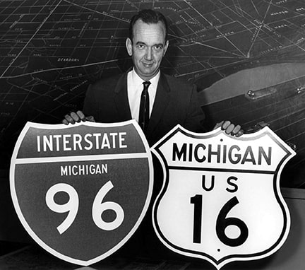
"Michigan State Highway Commissioner John C. Mackie, holds the new and old route marker signs at a press conference held in Detroit, Michigan. The new red, white, and blue Interstate Highway shields will be displayed along the Detroit-to-Muskegon freeway, which will become known as I-96, and will replace the current US-16 designation in the future." (Aug. 1959)
  • ​Massive reduction of US highway mileage in California, and subsequent collateral damage.  Starting in the mid-1960s, California deleted or severely truncated almost every US route in their state, for the reasons listed above (most of these were either intra-state routes, or else they paralleled new Interstates).  Because of its geographic location (with no other states to its west or south), California had more freedom to delete these designations than an interior state would have.  But suddenly California was devoid of several long, coast-to-coast, or border-to-border US routes, including 40, 60, 66, 70, 80, 91, and 99.  And this had a ripple effect, opening the door for neighboring states to do the same: for example, Arizona soon deleted or truncated its portions of US 60, 66, 70, and 80.  Route 66 was redundant with various Interstates all the way to its eastern terminus in Chicago, and by 1985 the entire US 66 designation had been decommissioned.
  • ​Significant reduction in US highway mileage due to eliminations of intra-state routes.  In the minutes of their June 1970 meeting, AASHO listed 20 single-state US routes.  Within the next decade, eight of the routes on that list had been decommissioned.  Altogether, about 20 intra-state US routes were decommissioned during the Years of Decline.
  • Deletion of several US route concurrencies.  Many of the truncations that took place during the Years of Decline were due to the elimination of what were considered unnecessary overlaps of two or more US route designations.
  • Extension of some US routes.  Despite losses elsewhere, some US highways that were not impacted by the Interstates continued to expand, although in general the pace of growth was slower than during the preceding Golden Age.

The Marginal Years

These charts show the years 1994-present in greater detail:
  • [chart for "main" routes]  
  • [chart for "branch" routes]
By the early 1990s, Texas had finished its truncations of US routes that were redundant with parallel interstates (US 66, 75, 80, 81, and 290).  That marked the end of the Years of Decline, and the beginning of the current phase in the history of US highways.  Today the US routes continue to serve non-interstate corridors, and in some cases they are quite heavily-traveled.  Yet despite this, in many ways the US highway system seems to have been pushed out towards the margins of transportation consciousness.  The current time period is difficult to characterize, mainly because of a pronounced lack of activity:
  • A sharp dropoff in the rate of new US route creation, and existing US route extensions.  In nearly three decades, only five new US routes have been designated (and one of those was simply a replacement for an older designation).
  • A matching decline in the rate of US route truncations and deletions.

Research and/or image credits: Jim Lindsay; Dale Sanderson; Dale Sauter
Page originally created 2019;
last updated Nov. 3, 2019.
Copyright © 1998-2023
Picture