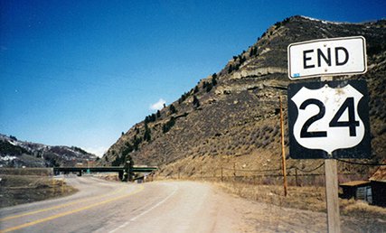
End of US highway 24 |
 |
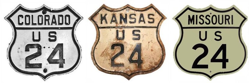
Summa
|
Summa
|
|
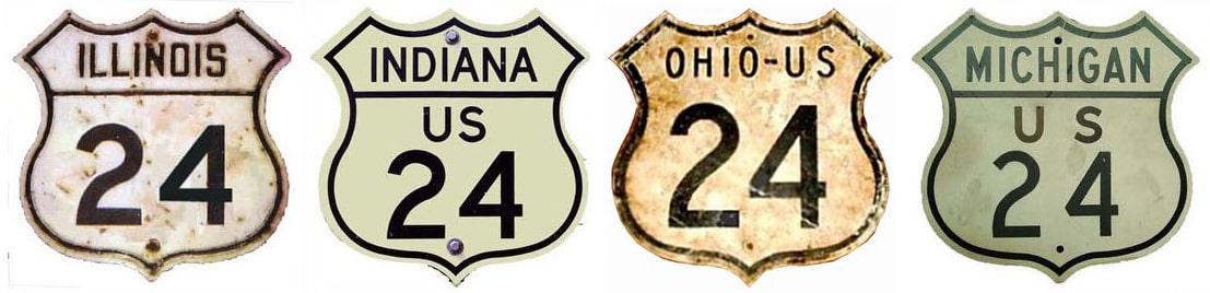
1926-1935
|
1935-1975
|
1975-1985
|
1985-present
|
|
Mileage: in 1989 AASHTO listed a figure of 1563 miles for US 24... however, that included the mileage of US 24's associated business routes. According to the state subtotals on AASHTO's 1989 spreadsheet, mainline US 24's actual end-to-end total at the time was 1540 miles. Our own 2020 measurement yielded 1549.8 miles (reroutings and realignments likely explain the difference). Historically, when US 24 went to Grand Junction, its distance was 1694.8 miles.
|
|
|
US 24 is primarily an east/west highway, but one could argue that its east "end" is at the Ohio/Michigan stateline in Toledo, because Michigan's 78-mile segment of US 24 is signposted as a north/south route. And personally, I think Colorado should sign the westernmost 67 miles of US 24 as a north/south route, too (that is, the segment between Minturn and its junction with US 285 near Buena Vista).
|
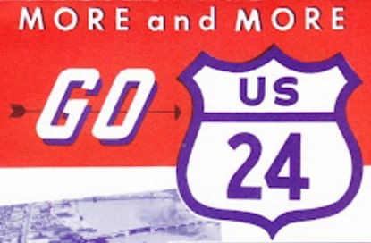
date unknown; linked to source
|
|
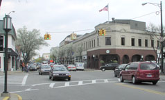
During the early years the north end of US 24 was in and around Pontiac. At first, Telegraph Road was not complete all the way north to Pontiac. So US 24 was routed west with US 16 along Grand River Avenue, and then north again on Orchard Lake Road, ending at Woodward Avenue (US 10) in Pontiac:
|
Hargraves, May 2003
|
|
That shows where Woodward would have gone, back when it still went straight. Ahead, Orchard Lake Road now leads to a parking garage, so the actual historic terminus is technically underneath the garage somewhere. In 1928, US 24 was routed east from Telegraph on Seven Mile Road, then north on Southfield Road, ending in Birmingham on Maple Road at Woodward:
|
Hargraves, May 2003
|
|
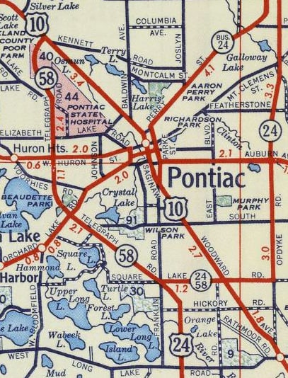
By 1930, US 24 followed Telegraph all the way up to Square Lake Road in Pontiac. From there one would think that traffic would have been directed east to end at Woodward (jct. US 10)...
Hargraves, May 2003
...but it seems that was not the case. Rather, US 24 ended oddly at a junction with two state routes (M-58 and M-24), just a mile shy of a junction with US 10, as shown on this map:
|
c. 1956, Gousha
|
|
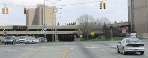
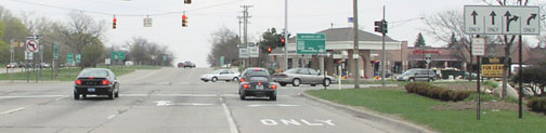
Later, US 10 was rerouted such that it overlapped US 24 into Pontiac. Someone who drove those roads regularly during the 1980s wrote with his recollection that, by then, Square Lake was signposted as Business 10, but US 24 still terminated at that same intersection. This photo, taken looking eastbound along Square Lake at Telegraph, illustrates a so-called "Michigan Left":
|
Google Maps Street View, Sep. 2019
|
For over a half-century, until 1987, the north beginning of US 24 was to the right on Telegraph. That was the year when the US 10 designation was removed from the Detroit-Bay City corridor. US 24 was extended to the left, along former US 10 and former M-58, northwest to its current terminus at I-75's interchange 93. The following photos show the exit to the north beginning of US 24 as seen from southbound I-75:
|
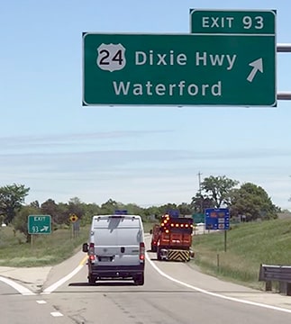
Sanderson, Jun. 2022
|
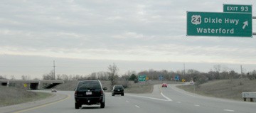
Ivy/Nitzman, 2009
At the bottom of that off-ramp, US 24 begins to the south (right) on Telegraph.
Heading the opposite direction, the final northbound trailblazer was posted on Telegraph after the intersection with White Lake Road: |
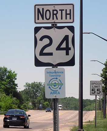
Sanderson, Jun. 2022
|
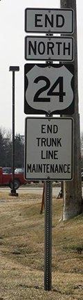
The US 24 designation ends about two miles ahead; this next shot was the author's first "End US highway" photo...
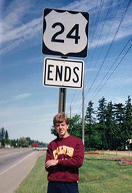
Sanderson, summer 1992
...and following are some replacement assemblies that have been posted since then:
|
attribution unknown
|
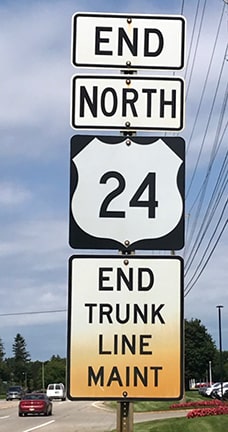
Morris, Jul. 2019
|
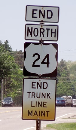
Sanderson, Jun. 2022
|
|
That "End" assembly was posted a fair distance north of the interchange. Right across the highway from there was a "Begin" sign:
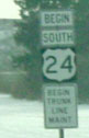
Garnell, Dec. 2002
|
Morris, Jul. 2019
|
Drivers continuing about a half-mile ahead encounter the first southbound confirming marker after the I-75 interchange:
Mortell, 2000
|
letterhead from 1937
|
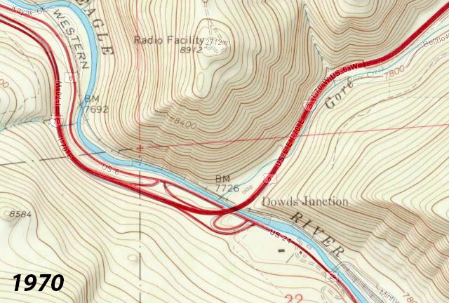
The original west end of US 24 was in Kansas City. Then in 1935, the designation was extended westward, taking over for what had until then been signed as "US 40-S". The west end of US 24 was then at US 50 in Grand Junction. That remained the case until 1975, when the US 24 designation was truncated to its current endpoint in Minturn. Here is a portion of the USGS 1:24k "Minturn" quad (with a modern basemap showing through), illustrating the interchange where US 24 ends today:
|
USGS, 1:24k series
|
|
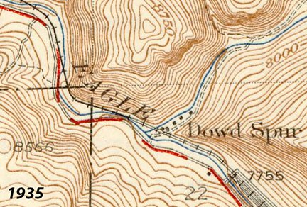
If you can imagine that map without I-70 (the thick red line) and its access ramps, you will have an idea of how things used to look here: basically there was only the road along the Eagle River (running between lower right and upper left). In 1926 this riverside highway became a segment of the newly-designated US 40-S, and that lasted for the next ten years:
|
USGS, 1:62k series
|
There was a primitive road going up Dowd Canyon (upper right) into what is now known as the Vail Valley, but it went only as far as today's East Vail. And there was no town of Vail, and there was no "Vail Pass" (now about 20 miles east).
|
At the same time that map was issued, the highway was renumbered as US 24. The next year, the US 6 designation was extended west of Denver, but Vail Pass still was not open. So US 6 traffic was routed south from "Wheeler Junction" (today's Copper Mountain) via what is now CO hwy. 91, over Fremont Pass to Leadville, where it met US 24. From there the two routes overlapped back up through here, and on to Grand Junction. That lasted only a few years: after Vail Pass was completed in about 1940, US 6 was signed along that route (roughly the same corridor as today's I-70, although the freeway was not complete through this area until the 1970s). US 6 then used Dowd Canyon to get to this point, and joined with US 24 here:
|
USGS, 1:62k series
|
|
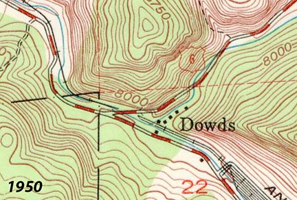
That still left the overlap between there and Grand Junction that lasted nearly 40 years; in fact it became so ingrained in western Colorado that many maps still label the road "US 6 & 24". Last time I checked, the local phone book listed a "6 & 24 Trailer Court" in Rifle; in fact official CDoT documents as recent as 2003 still refer to the road as "US 6-24"! Below is a scan of one of the last state highway maps to show the US 6-24 concurrency west of Minturn:
|
c. 1975, CDoT
|
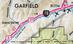
(Incidentally, note also the town of "Grand Valley", which is now known as Parachute.) The US 24 designation was officially removed from that segment in 1975; here is that agenda item from the minutes of AASHTO's meeting in November of that year:
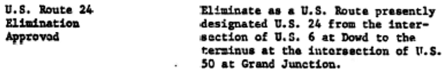
|
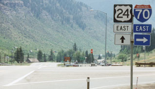
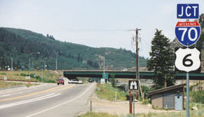
The 1977 winter CDoT map was the first to indicate the Minturn terminus. Many maps show a "Dowds" or "Dowds Junction" at the spot. That is not a town, and most Coloradoans have never heard of it; it is probably the name of the railroad siding just to the south. At any rate, it is where Gore Creek flows into the Eagle River. Today, the town of Minturn has annexed all the way up to the interchange, but "downtown" Minturn is about two miles south (or "east", since US 24 is signed as an east-west highway). We will start with photos from westbound I-70/US 6; this is the sign for the exit to the west beginning of US 24:
|
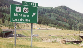
Sanderson, June 2002
|
|
The Eagle River runs across the bottom of that shot; in the lower right corner the railroad bridge over the mouth of Gore Creek is visible. The bus is on US 6-24. I-70 uses the overpass at left; the offramp is on the far side (the green exit sign in the distance is barely visible) and it curves down to US 6-24 at far right. That sign was replaced sometime before 2015; here is a more recent shot (the small "Aspen" is on a fold-up sign that is displayed only when Independence Pass is closed):
|
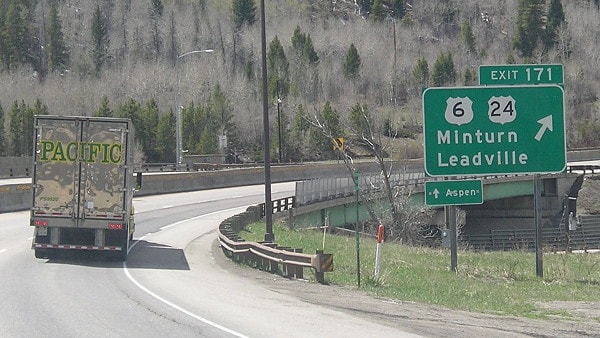
Morrison, Apr. 2017
|
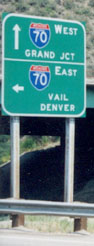
Next are some shots of what drivers have seen at the stop sign at the end of that offramp over the years:
Karners, Aug. 2010
|

Dienhart, Aug. 2022
|
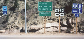
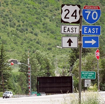
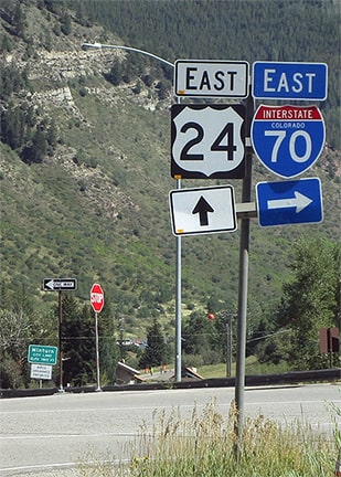
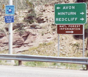
As we will see below, the information presented there is different from what one sees from the eastbound offramp. If a driver turns to the right there, towards Minturn, they will immediately see this assembly:
Sanderson, June 2002
|
Sanderson, June 2015
|
Dienhart, Aug. 2022
|
|
That is the true beginning of eastbound US 24: if a traveler is following US 6 eastbound, they must turn to the right there to join with I-70 (despite the lack of signage to that effect). But traffic exiting from eastbound I-70 does not see that sign. Instead, one must travel about five miles ahead, and well beyond Minturn, before the first confirming marker is posted:
|
Sanderson, Jun. 2015 (gone after 2016)
|
Schecter, May 2010
|
|
That was right at the first switchback, where the highway begins climbing out of the Eagle River floodplain and ascends to the so-called "Battle Mountain summit" (the roadcut visible in that photo is also part of US 24). That term does not refer to the actual summit of Battle Mountain, but rather the road's highpoint along one of its shoulders, before it drops back down to the river near Red Cliff. Right across the road from there is the last "normal" westbound US 24 trailblazer...
|
Sanderson, June 2015
|
...although there was one more reference to US 24 ahead in Minturn, prompting drivers to curve left instead of staying on Main Street:
Sanderson, June 2015
|
|
Back in 1998, if one were to continue ahead a couple miles, they would have seen this sign:
Sanderson, Apr. 1998
|
That was the I-70 overpass in the background. That sign was gone by 2002; all that was left is the assembly shown below, posted a bit further ahead, along with the green sign visible in the distance:
|
|
Signage there was incomplete (although that is not unusual for Colorado, which generally does not acknowledge US routes where they run concurrently with interstates). Motorists were not told that eastbound US 6 traffic should follow eastbound I-70, or that westbound US 6 is straight ahead. Those signs have since been replaced, but the new ones are equally uninformative:
|
Sanderson, Sep. 2021
|
|
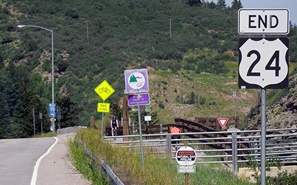
If a driver continues straight ahead, they encounter a newer "End" sign on the far side of the overpass:
|
Sanderson, June 2002
|
Sanderson, June 2015
|
|
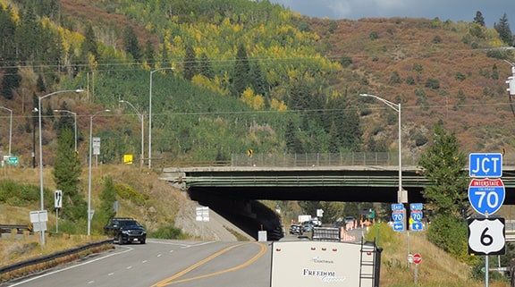
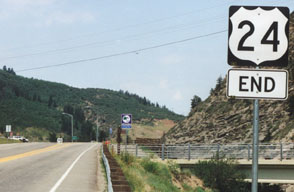
At far left is the onramp to westbound I-70, as well as the offramp from westbound I-70. The true end of US 24 is there, because that is where (implied) westbound US 6 exits I-70 and then continues straight ahead. Sometime prior to 2010 the "End" tab was moved to the top, which is generally a more common configuration for "End" assemblies. The bridge at right is for the Dowd Junction recreation trail that goes up Gore Creek to Vail. According to the 1950 1:62k USGS topo shown above, that bridge is situated at approximately the same location as the old US 6 bridge that was used before I-70 was built. So historically this is the point where US 6 and 24 joined and continued ahead together to Grand Junction. Next is signage from eastbound I-70:
|
Sanderson, June 2002
|
Sanderson, Aug. 2017
|
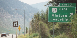
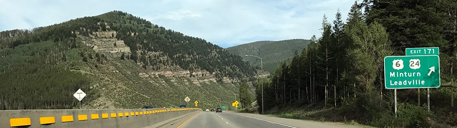
Formerly US 6 was not indicated for this direction -- probably because not many people are going to head back the way they just came from. But sometime after 2010 that sign was replaced, and now it does reference US 6. At the bottom of that offramp was the signage shown here:
|
Sanderson, Apr. 1998
|
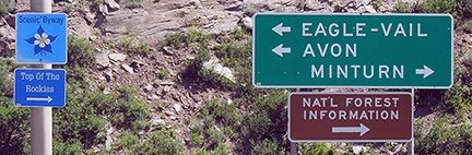
Sanderson, June 2015
|
That info was essentially the same as what was presented at the westbound offramp, except it was not clear which way is US 24, and which is US 6. Not only that, but now the control towns on that green sign have also been changed: Red Cliff (to the right) has been replaced by Eagle-Vail (to the left), which is perplexing. It is true that at milepost 169 there is no eastbound exit for Eagle-Vail, but if that community is your destination, you would be more likely to use the previous exit (168), rather than coming all the way to this point and then backtracking. Anyway, US 24 begins to the right, and the road takes travelers past several of Colorado's 14-ers, and in general some spectacular scenery. (More photos from the westernmost ten miles of US 24.)
Research and/or photo credits: Chris Bessert; Paul Dienhart; Dan Garnell; Don Hargraves; Brent Ivy; Karin and Martin Karner; Terry Morris; Jeff Morrison; Robert Mortell; Alex Nitzman; David Outen; Paul Pinto; Dale Sanderson; James Schecter; Dave Schul; Michael Summa
Page originally created 1998;
last updated Feb. 7, 2024.
last updated Feb. 7, 2024.
