US Ends .com
  • Home
  • Store
    • US highway map
    • Florida US highway map
  • Endpoints
    • US 1 - US 9 >
      • 1 >
        • 201
        • 301
        • 401 [i]
        • 401 [ii]
        • 401
        • 501
        • 601
        • 701
      • 2w >
        • 102
      • 2e >
        • 202
        • 302
      • 3
      • 4 >
        • 104
      • 5
      • 6 >
        • 106
        • 206
      • 7
      • 8
      • 9 >
        • 109*
        • 209
        • 309
    • US 10 - US 19 >
      • 10 >
        • 110
        • 210
        • 310
        • 410
      • 11 >
        • 111
        • 211
        • 311
        • 411 [i]
        • 411 [ii]
        • 411
        • 511*
        • 611
        • 711*
      • 12 >
        • 112
        • 212
        • 312
      • 13 >
        • 113
        • 213
      • 14
      • 15
      • 16 >
        • 116
        • 216
      • 17 >
        • 17-1
        • 117 [i]
        • 117
        • 217
      • 18 >
        • 118
        • 218
      • 19 >
        • 119
        • 219
        • 319
    • US 20 - US 29 >
      • 20e >
        • 120
        • 220
        • 320
        • 420
      • 20w
      • 21 >
        • 121 [i]
        • 121
        • 221
        • 321
        • 421
        • 521
      • 22 >
        • 122 [i]
        • 122 [ii]
        • 222
        • 322
        • 422e
        • 422w
        • 522
        • 622*
      • 23 >
        • 123 [i]
        • 123
        • 223
      • 24 >
        • 124
        • 224
      • 25
      • 26 >
        • 126
      • 27 >
        • 127
        • 227
      • 28
      • 29 >
        • 129
    • US 30 - US 39 >
      • 30 >
        • 130
        • 230
        • 330
        • 430
        • 530
        • 630*
        • 730
        • 830
      • 31 >
        • 131
        • 231
        • 331 [i]
        • 331
        • 431
      • 32
      • 33
      • 34
      • 35
      • 36 >
        • 136
      • 38 >
        • 138
    • US 40 - US 49 >
      • 40 >
        • 140
        • 240
        • 340
      • 41 >
        • 141
        • 241 [i]
        • 241 [ii]
        • 341
        • 441 >
          • 441n
          • 441s
        • 541
        • 641
      • 42
      • 43
      • 44
      • 45
      • 46
      • 48 [i]
      • 48 [ii]
      • 48
      • 49
    • US 50 - US 59 >
      • 50 >
        • 150
        • 250
        • 350
        • 450
        • 550
        • 650
      • 51 - 55 >
        • 51 >
          • 151
        • 52 >
          • 152
        • 53
        • 54 >
          • 154
        • 55
      • 56 >
        • 156
      • 57
      • 58 >
        • 158
        • 258
      • 59 >
        • 159
        • 259
    • US 60 - US 69 >
      • 60 >
        • 160
        • 260
        • 360
        • 460
      • 61 - 65 >
        • 61 >
          • 161
        • 62
        • 63 >
          • 163 [i]
        • 64 >
          • 164 [i]
          • 164 [ii]
          • 264
        • 65 >
          • 165
      • 66 >
        • 166
        • 266
        • 366 [i]
        • 366 [ii]
        • 466
        • 566
        • 666
      • 67 >
        • 167
      • 68 >
        • 168
      • 69 >
        • 169
    • US 70 - US 79 >
      • 70 >
        • 170
        • 270 [i]*
        • 270
        • 370
        • 470
      • 71 >
        • 171
        • 271
        • 371 [i]
        • 371
      • 72 - 76 >
        • 72
        • 73
        • 74
        • 75 >
          • 175
          • 275
        • 76 >
          • 176
          • 276
      • 77 >
        • 177
        • 277
        • 377
      • 78 >
        • 178
        • 278
        • 378
      • 79
    • US 80 - US 89 >
      • 80 - 84 >
        • 80 >
          • 180 [i]
          • 180
          • 280
          • 380
        • 81 >
          • 181
          • 281
        • 82
        • 83 >
          • 183
          • 283
          • 383
        • 84
      • 85 - 89 >
        • 85 >
          • 185
          • 285 [i]
          • 285
          • 385 [i]
          • 385
          • 485
        • 87 >
          • 187
          • 287n
          • 287s
        • 89n
        • 89s >
          • 189 [i]
          • 189
    • US 90 - US 99 >
      • 90 - 94 >
        • 90 >
          • 190
          • 290
        • 91 >
          • 191 >
            • 191n
            • 191s
          • 491
        • 92 >
          • 192
        • 93
        • 94
      • 95 -98 >
        • 95 >
          • 195
          • 295
          • 395
        • 96 [i]
        • 96
        • 97 >
          • 197
        • 98
      • 99 >
        • 199
        • 299
        • 399
    • Anomalies >
      • 101
      • 163
      • 400
      • 412
      • 425
  • Places
    • A-L >
      • A >
        • Aberdeen
        • Albuquerque
        • Amarillo
        • Apalachicola
        • Astoria
        • Atlantic
      • B >
        • Baltimore
        • Baton Rouge
        • Bay Area
        • Bishop
        • Boone
        • Brady
        • Bristol
        • Brownsville
        • Brunswick
      • C >
        • Charleston
        • Chattanooga
        • Chicago
        • Cincinnati
        • Cleveland
        • Cody
        • Corpus
        • Cortez
        • Council Bluffs
        • Covington
        • Crescent
        • Cumberland Gap
      • D-E >
        • Dallas
        • Des Moines
        • Detroit
        • Dothan
        • Douglas
        • El Paso
        • Eugene
        • Erie
      • F >
        • Farmington
        • Flagstaff
        • Florence
        • Fox Valley
        • Franklin
      • G >
        • Gallup
        • Grand Junction
        • Grand Portage
        • Grayling
        • Great Falls
        • Greeley
      • H-I >
        • Hardeeville
        • Harrisburg
        • Holbrook
        • Idaho Falls
        • Int'l Falls
      • J-K >
        • Jacksonville
        • Joplin
        • Junction
        • Kansas City
        • Keokuk
        • Key West
        • Kingman
      • L >
        • Laredo
        • Lewiston
        • Long Beach
        • Los Angeles
        • Louisville
        • Lubbock
    • M-R >
      • M >
        • Mackinaw
        • Madison
        • Maryhill
        • Maysville
        • Miami
        • Midway
        • Miles City
        • Milford
        • Milwaukee
        • Minneapolis
        • Mobile 31
        • Mobile 31-43-45
        • Montgomery
        • Monticello
        • Mount Vernon
      • N-O >
        • Nags Head
        • Naples
        • Natchez
        • New Castle
        • New Orleans
        • Niagara
        • Norlina
        • Ocean City
        • Oklahoma City
      • P >
        • Pee Dee
        • Pembina
        • Pensacola
        • Petersburg
        • Philadelphia
        • Piegan
        • Pineville
        • Port Arthur
        • Portsmouth
      • Q-R >
        • Quad Cities
        • Rapid City
        • Raton
        • Reading
        • Richmond
        • Rockingham
        • Rouses Point
    • S-Z >
      • S >
        • San Antonio
        • San Antonio NM
        • San Diego
        • Santa Fe
        • Savannah
        • Sioux
        • Springer
        • Springfield
        • St. Ignace
        • St. John
        • St. Paul
        • St. Pete
      • T-U-V >
        • Tallahassee
        • Tampa
        • Toledo
        • Trinidad
        • Ucolo
        • VA Beach
      • W >
        • Walterboro
        • Waverly
        • West Memphis
        • Wilmington
        • Wilson
        • Wrightsville
      • Y >
        • Yellowstone E
        • Yellowstone N
        • Yellowstone NE
        • Yellowstone S
        • Yellowstone W
  • Highways
    • Map of all endpoints
    • Sources
    • History
    • 1926 almost-routes
    • Intra-state routes
    • Numbering
    • Colors
    • Gaps
    • Blog
  • Bonus
    • Colorado >
      • Lowest point
      • Antipodes
      • Toponymy >
        • Roots
      • Colloquialisms
      • Populations
      • Denvers
    • Washington Meridian
    • Watersheds >
      • Headwaters Hill
      • Three Waters Mtn.
      • Parting of the Waters
    • Geo-centers >
      • 48 states
      • 50 states
      • North America
    • State corners >
      • AZ-CO-NM-UT
      • CO-UT-WY
      • CO-NE-WY
      • CO northeast
      • CO-KS-NE
      • CO-KS-OK
      • CO-NM-OK
      • NM-OK-TX
      • NM southeast
      • TX northwest
    • ooss.space
  • Connect
    • Author/history
    • Rationale
    • Contact
    • Contributors
    • Submissions

US 340

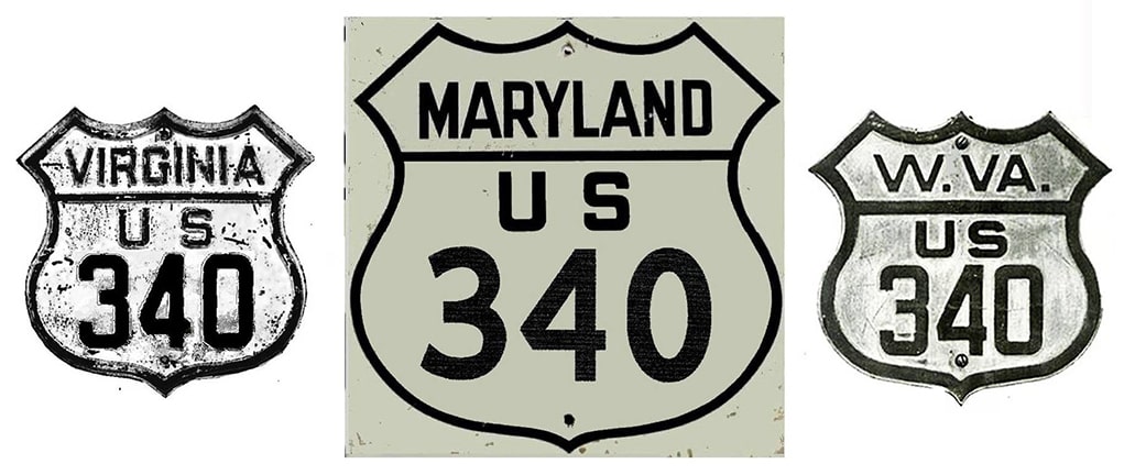
End of US highway 340

View a map showing this route.
Get your very own map showing all current and historic US routes!
1926-1935
  • East: Frederick, MD
  • West: Winchester area, VA
1935-1954
  • East: Frederick, MD
  • West: Winchester, VA
1954-present
  • East: Frederick, MD
  • South: Greenville, VA
Note: US 340 is signed east-west only in Maryland.  It is signed north-south in Virginia and West Virginia.  Mileage: in 1989 AASHTO listed a figure of 156 miles for US 340.  That closely matches our own 2020 measurement, which yielded 155.6 miles.
Picture
Summa

The east end of US 340 has always been in Frederick.  Originally it came into town on what is now MD hwy. 180, which aligned with Jefferson Street.  The route could have ended either at Patrick Street (historic US 40, current MD 144), or it may have overlapped with US 40 east a few blocks, ending at Market Street (historic US 15, current MD 355), where it would have shared a terminus with US 240:
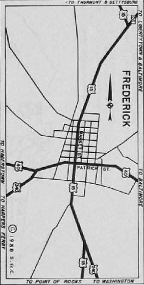
Picture
c. 1938, MD DoT

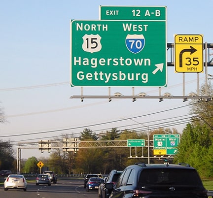
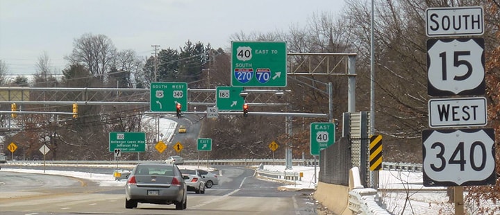
​When the freeways through town were built, US highway traffic was rerouted onto them, and now US 340 ends at its junction with the US 40 freeway.  There was no "End" sign; only directions instructing how drivers on northbound US 15 should continue:
Picture
Karners, Jan. 2017
Historically, US 340 continued ahead on Jefferson for about another mile.  These photos show the signs posted at its approach to historic US 40, as well as the distressed assembly currently posted at the actual historic terminus:
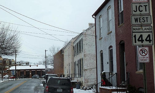
Picture
Karners, Jan. 2017
Picture
Karners, Jan. 2017
Heading west on old US 40 (Patrick), the road makes a slight curve to the right, while to the left on Jefferson was the original east beginning of US 340:
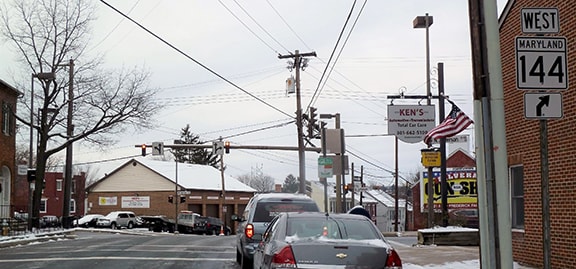
Picture
Karners, Jan. 2017
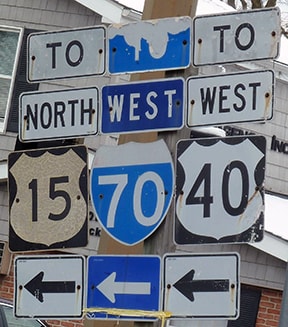
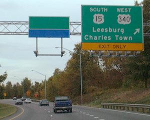
Today, if a driver turns left there and continues on Jefferson for about a mile, they will see the first reference to US 340 at the interchange with current US 40...
Picture
Karners, Jan. 2017
...and not far beyond there is the first confirming marker.  This photo not only shows how modern US 340 curves off to the left, but it also illustrates the road straight ahead: Jefferson Pike, or modern MD 180, which is the original alignment of US 340:
Picture
Karners, Jan. 2017
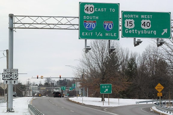
These photos were taken heading south on Frederick Freeway (which is southbound US 15 and eastbound US 40 at this point).  Southbound US 15 continues to the right, and US 340 begins at that exit as well:
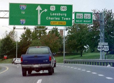
Picture
Field, Oct. 2001
Picture
Field, Oct. 2001

When US 340 was commissioned in 1926, it ran only about 40 miles southwest of Frederick, but there is some ambiguity as to where it actually ended.  AASHO's 1926 map showed it ending at either Boyce or Millwood (the junction with US 50 was not labeled).  At first glance their 1927 route log appears to indicate the west end was Berryville, but upon closer inspection they got two towns out of sequence, and they actually meant Millwood.  Meanwhile, Virginia DoT maps showed four different endpoints within a span of eight years:
  • The 1927 map showed US 340 ending in Winchester (jct. US 11).
  • The 1928 map showed US 340 ending in Millwood (jct. US 50).
  • The 1933 map showed US 340 ending in Boyce (jct. US 50).
  • The 1936 map showed US 340 ending in Winchester again.
Historical documents in the AASHO archive do not provide a satisfactory explanation, but they do offer some clues.  From what I can ascertain, the issue was that the roads between Berryville and US 50 (leading to both Boyce and Millwood) were not in satisfactory condition to be considered part of the US route system.  So instead the US 340 designation was truncated at Berryville and extended into Winchester.  The vahighways.com US 340 page is a great source of additional information. 
By 1935 most (if not all) maps agreed that US 340 went to Winchester...
Picture
c. 1939, Rand McNally
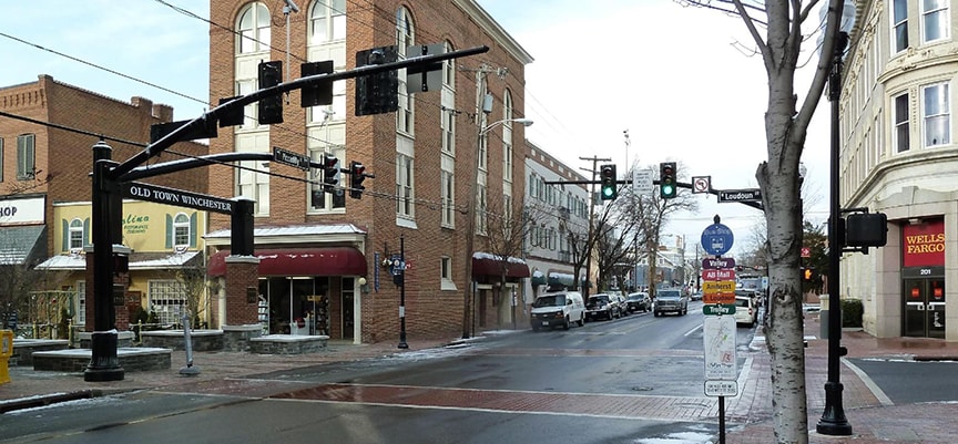
...and that remained the case for over 20 years.  This photo was taken in Winchester, looking west on Piccadilly Street: ​
Picture
Karners, Jan. 2017
Originally southbound US 11 was to the left on Loudoun Street, while northbound was straight ahead, so that photo shows the perspective of a driver at the historic west end of US 340.  ​

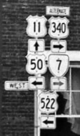
This next shot shows a sign tree that was posted one block behind the camera, looking north on Cameron at Picadilly.  It was taken in 1956, just two years after US 340 had been routed away from Winchester (more on that below).  But that was during an eight-year period during which the original US 340 into Winchester was designated "Alternate US 340".  So, except for the "alternate" tab, this is probably exactly what the west beginning of US 340 looked like:
Picture
c. 1956 (linked to source)
All during those early years, US 340 could be considered to run east-west, so its number (implying an east-west branch of US 40) made sense.  But then in about 1954, US 340 was truncated at Berryville and rerouted to go through Boyce.  But this time it was extended far to the south of US 50, essentially running all the way through the Shenandoah River valley.  It was probably at this time that signage on US 340 in Virginia was changed to north-south.  The number of the route should have been changed too -- US 115 would have been a reasonable choice.  But that did not happen, and ever since then US 340 has been one of a small percentage of US routes whose number belies its direction.
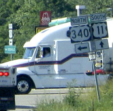
Since 1954, the south end of US 340 has been at US 11 just outside Greenville.  This photo was taken approaching the end of the route:
Picture
Nitzman, June 2005
By 2013 that assembly had been replaced, but format was identical.  Just a ways ahead, this next one shows the signage at the actual intersection where US 340 ends:
Picture
Nitzman, June 2005
Southbound US 11 is to the left; there was a sign indicating that, but it was off the left edge of the photo.  It is barely visible at far left in this shot, which was taken approaching from southbound US 11:
Picture
Nitzman, June 2005
Heading the opposite direction, the freeway overpasses are visible in the middleground, and the south beginning of US 340 is indicated thus:
Picture
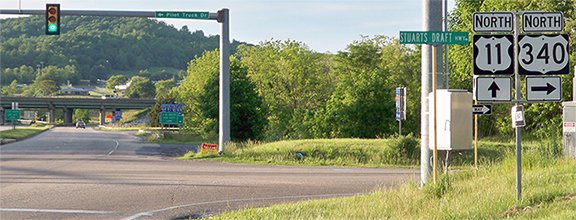
Karner, May 2013 (unchanged since at least 2005)
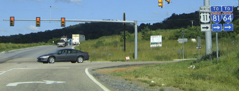
For drivers taking that right turn, the first northbound reassurance marker formerly looked like this...
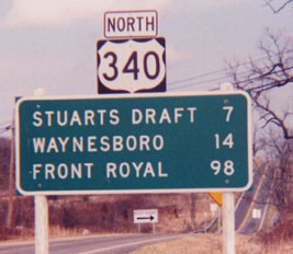
Picture
Summa, 1994
...and the unusual arrow sign in the distance said "KEEP RIGHT".  That was because, prior to a realignment that took place in about 2000, US 340 had a slight bifurcation there, and the sign was related to that.  This was very close to interchange 213 on I-64/81 (just south of Staunton).

Research and/or photo credits: Chris Elbert; Andy Field; Karin and Martin Karner; Alex Nitzman; Mike Roberson; Dale Sanderson; Ben Schumin; Dave Strong; Michael Summa
Page originally created 2004;
last updated Apr. 19, 2022.
Copyright © 1998-2023
Picture