End of US highway 178 |
 |
Summa
|
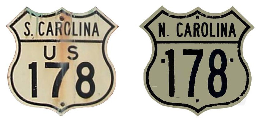
Note: US 178 is signed east-west in South Carolina, but north-south in North Carolina.
|
|
Mileage: in 1989 AASHTO listed a figure of 249 miles for US 178... however, that included the mileage of US 178's associated bypass routes. According to the state subtotals on AASHTO's 1989 spreadsheet, mainline US 178's actual end-to-end total at the time was 237 miles. That closely matches our own 2020 measurement, which yielded 238.9 miles (reroutings and realignments likely explain the difference).
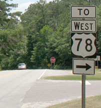
US 178 was commissioned in 1932, and its east end has always been at its junction with its parent route (US 78) in Dorchester: |
Prince, 2000
|
Straight ahead is eastbound US 78, towards Charleston. The fork to the right goes to westbound 78; "central" Dorchester is about two miles in that direction.
|
|
US 78 heads northwest out of Charleston, paralleling I-26 for about 20 miles until Dorchester. From there, US 78 heads more westerly, towards Aiken and Augusta GA... but there US 178 begins by continuing roughly along the same corridor as I-26 for another 30 miles or so to Orangeburg (at that point, it too bears west of I-26). All of these next shots were taken from westbound US 78:
|

Patriarca, 2003
|
Patriarca, 2003
|
Nitzman, May 2007
|
|
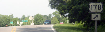
Heading east on US 78, the east beginning of US 178 is marked thus...
|
Nitzman, May 2007
|
...and travelers who take that turn soon encounter the first westbound sign on US 178:
|

Nitzman, May 2007
|
|
Originally US 178 ran only as far west as Anderson. This photo was taken looking east on River Street. During the 1930s, US 29 was routed along the crossroad (Main Street), and straight ahead on River was the west beginning of US 178:
|
Karner, May 2013
|
|
In about 1937 the US 178 designation was extended due north from Anderson to Rosman. Formerly US 64 was routed through Rosman, and for decades US 178 ended right in town:
|
Sanderson, Oct. 2000
|
|
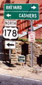
That was looking northeast, where Chestnut Street dead-ends at the high school on Church Street (old US 64). Notice that, for travelers wanting to head east from this point (towards Brevard), the sign still recommends that they use the old highway to the right (instead of going left to modern US 64). Historically US 178 ended there, but later it was extended about a half-mile further north (left) along old US 64, to its junction with the new US 64:
|
Sanderson, Oct. 2000 (unchanged as of 2017)
|
|
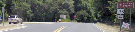
There was no "End" sign present to proclaim US 178's terminus at US 64. These shots show the north beginning of US 178, approaching via eastbound US 64:
|
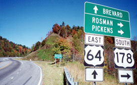
Sanderson, Oct. 2000
|
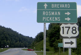
Nitzman, July 2004 (unchanged as of 2023)
|
|
The road cut through the hillside for the "new" US 64 is visible at left. That bypasses the town of Rosman, and it was not built until about 1980. Here is a shot from the opposite direction...
|
Nitzman, July 2004
|
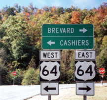
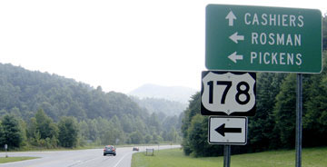
...and drivers who take that left turn will soon see the first southbound confirming marker:
|

Nitzman, July 2004
|
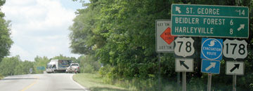
In 6.5 miles US 178 crosses into South Carolina, and then the road is signed "East" (even though Anderson is almost due south).
Research and/or photo credits: Martin Karner; Alex Nitzman; Chris Patriarca; Adam Prince; Dale Sanderson; Michael Summa; Charles Turner; Morgan Younce
Page originally created 2000;
last updated Dec. 9, 2023.
last updated Dec. 9, 2023.
