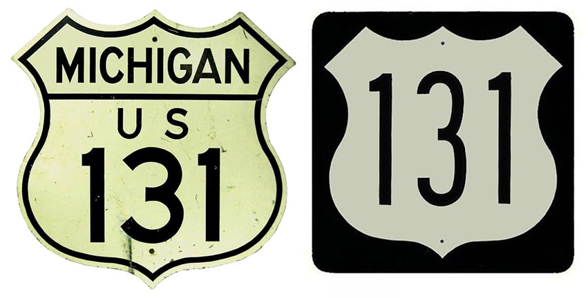
End of US highway 131 |
 |
|
1926-1939
|
1939-1958
|
1958-1971
|
1971-present
|
Summa
|
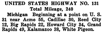
Mileage: in 1989 AASHTO listed a figure of 279 miles for US 131... however, that included the mileage of US 131's associated business route. According to the state subtotals on AASHTO's 1989 spreadsheet, mainline US 131's actual end-to-end total at the time was 271 miles. That closely matches our own 2020 measurement, which yielded 270.3 miles.
|
US 131 has always been essentially a Michigan intra-state route. Even after 1980 (when Indiana reluctantly agreed to allow the designation in their state), its Indiana segment is less than one mile in length. However -- despite the fact that its endpoints are small towns -- US 131 is an important corridor in Michigan, connecting such places as Kalamazoo, Grand Rapids, and Cadillac, and much of its length has been upgraded to freeway.
|
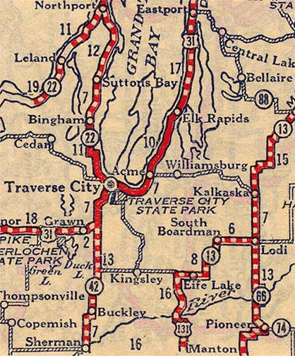
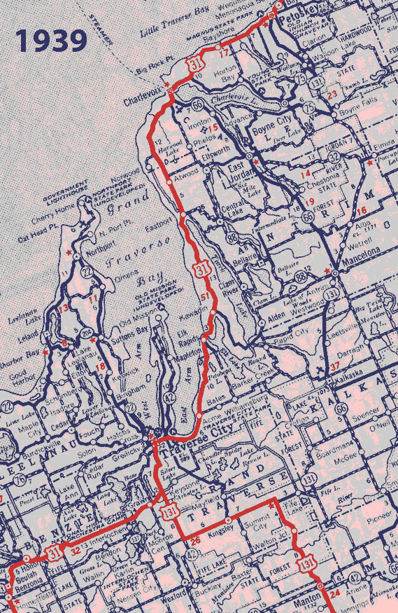
All of AASHO's early route logs (starting in 1927) noted that the north beginning of US 131 was near Acme, Michigan. That was still indicated on this one from 1935 (nearly a decade after the US route system was established):
|
|
Several maps from the late 1920s indicated the Acme terminus as well, including this one (which AASHO published when it inaugurated the US route system in 1926)...
c. 1926, AASHO
...and this one, published in the same year by a highway booster organization:
|
c. 1926, National Highways Assn.
|
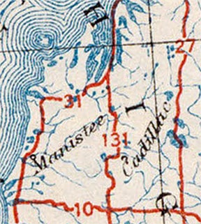
The truth is, Michigan had been planning to build a highway between Acme and Fife Lake, so they informed AASHO that the north terminus of US 131 would be in Acme. However, that road did not actually exist yet, so maps soon began indicating that US 131 had a temporary endpoint at Fife Lake:
c. 1927, Rand McNally
|
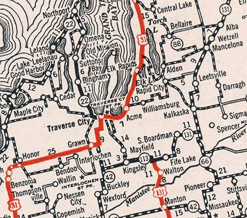
c. 1931, Clason
|
|
So for awhile, the defacto north endpoint of US 131 was at (or nearly at) the junction where M-186 ends today, between Fife Lake and Kingsley. This photo was looking west on M-186; US 131 originally began to the left (or possibly also continued to the right for one-half mile):
|

Meier, Sep. 2002
|
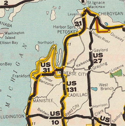
By 1934 it was becoming apparent that Michigan was not going to build the highway between Fife Lake and Acme after all. At least one commercial mapmaker started showing US 131 jogging west, then north, finally forming a connection with its ostensible "parent" route (US 31) just south of Traverse City...
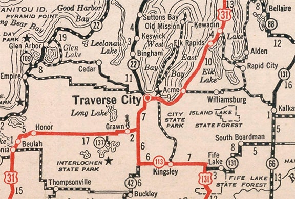
c. 1934, Rand McNally
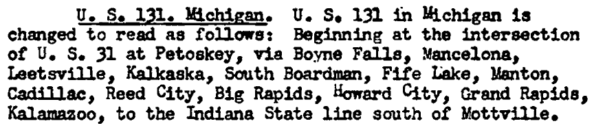
...but it appears that was not Michigan's idea (at least not initially), because their own official state highway maps did not show that change until the Winter 1938 edition. Furthermore, it is doubtful that the routing through Kingsley was ever signposted as US 131, because already by early 1939 Michigan had sent a request to have AASHO change the north terminus of US 131 to Petoskey. Permission was granted in June:
Michigan's 1939 maps reflected that change, as did commercial maps starting the next year:
|
Rand McNally, c. 1939 and 1940
|
|
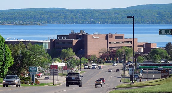
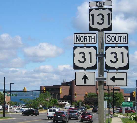
US 131 still terminates in Petoskey; it enters town from the south on Spring Street, and just before the terminus drivers are treated to an excellent view across Little Traverse Bay:
|
Sanderson, Jun. 2022
|
|
US 31 approaches Petoskey from the west via Charlevoix Avenue. At the intersection of the two, US 131 ends, and US 31 continues north into downtown via Spring...
|
Aho, May 2000
|
Ivy/Nitzman, 2009
|
Morrison, July 2018
|
Dienhart, Aug. 2020
|
Sanderson, Jun. 2022
|
|
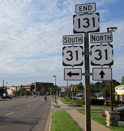
...although for the first year or two, northbound US 31 was to the right on Charlevoix.
In these photos, the view was east on Charlevoix, approaching Spring: 
Stilwell, Nov. 2005
|
Morrison, July 2018
|
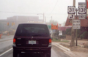
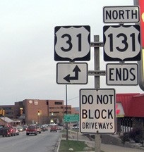
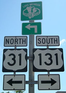
US 31 continues to the left on Spring, and to the right is the north beginning of US 131.
|
|
These next photos were taken looking south on Spring:
|
Morrison, July 2018
|
Sanderson, Jun. 2022
|
|
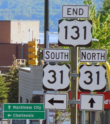
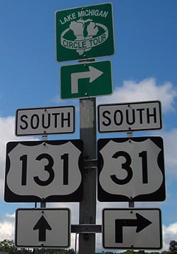
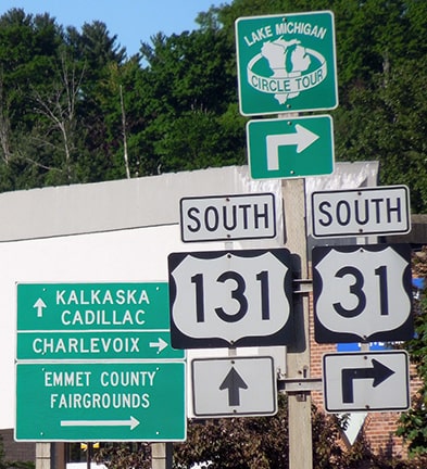
US 31 continues to the right on Charlevoix, but straight ahead on Spring is the north beginning of US 131. For travelers continuing straight, the first southbound US 131 confirming marker is posted shortly:
|
Stilwell, Nov. 2005
Morrison, July 2018
|
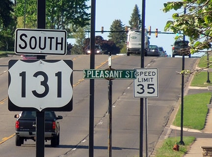
Sanderson, Jun. 2022
|
|
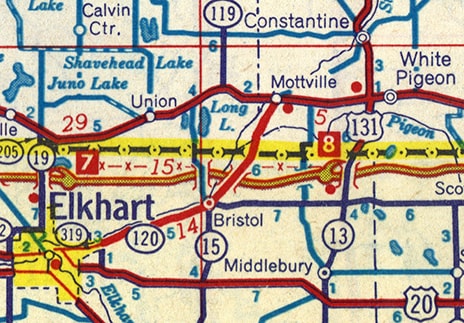
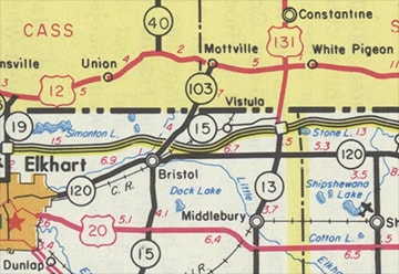
On its south end, US 131 originally continued west from White Pigeon with US 112 (today's US 12) to Mottville, and then south to the Indiana line (via today's M-103)...
|
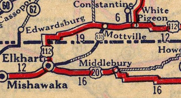
c. 1927, Rand McNally
|
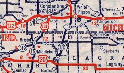
c. 1939, Rand McNally
|
|
...but Indiana steadfastly refused to sign US 131 in their state for decades. This photo was taken at the Indiana line about three miles south of Mottville:
|
Hargraves, Sep. 2002
|
|
There, northbound IN hwy. 15 becomes M-103. The smaller road heading off to the left is now known as "Old M-103"... but even before that, it was the original south beginning of US 131. That designation was switched over to modern M-103 (on the right) in 1942. Here we are looking south on Old M-103 where it meets modern M-103. The Indiana line is on the right edge, and that was the original south end of US 131:
|

Hargraves, Sep. 2002
|
|
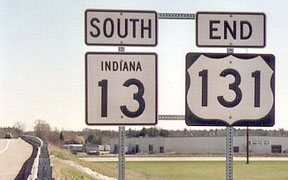
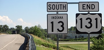
In 1959 the US 131 designation was changed such that it continued south (rather than west) from White Pigeon. However, it continued to end at the Indiana line for a couple more decades:
|
c. 1959, Gousha
|
|
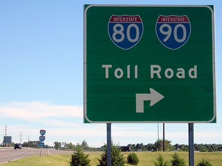
Finally in 1971, the US 131 designation was extended just barely into Indiana, ending at its junction with I-80/90 (or the Indiana East-West Toll Road), about five miles north of Middlebury (although Indiana may not have signposted this extension until 1980):
|
c. 1981, IN DoT
|
|
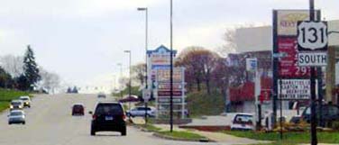
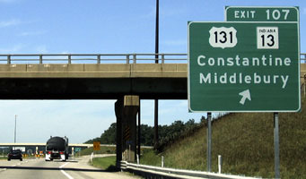
This view shows the exit to the south beginning of US 131, as seen from westbound I-80/90:
|
Field/Nitzman, Sep. 2005
|
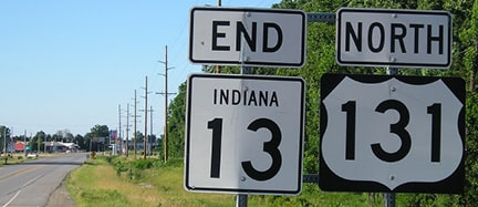
It is actually the overpass in the foreground which carries US 131 and IN 13 traffic; the interchange uses its own overpass (visible in the background). For drivers heading south on the first overpass, the signage shown here is posted...
Morrison, July 2018
|
Camp, Apr. 2003
|
Dienhart, Jun. 2016
|
|
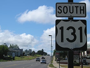
...and heading the opposite direction, one sees this assembly, including the first northbound confirming marker:
|
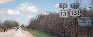
Enslin, 2001
|
Morrison, July 2018
|
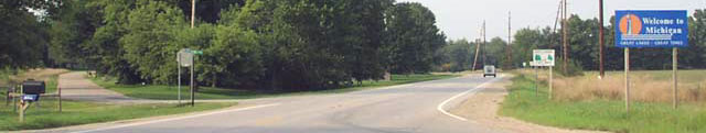
Barely visible in the distance is the big blue sign that marks the Michigan stateline. That is where US 131 began before it was extended a fraction of a mile into Indiana.
Research and/or photo credits: Jody Aho; Christopher Bessert; Barry Camp; Paul Dienhart; Jon Enslin; Andy Field; Don Hargraves; Brent Ivy; Eric Meier; Jeff Morrison; Alex Nitzman; Dale Sanderson; David Stilwell; Michael Summa
Page originally created 2000;
last updated Dec. 8, 2023.
last updated Dec. 8, 2023.
