US Ends .com
  • Home
  • Store
    • US highway book
    • US highway map
    • Florida US highway map
  • Endpoints
    • US 1 - US 9 >
      • 1 >
        • 201
        • 301
        • 401 [i]
        • 401 [ii]
        • 401
        • 501
        • 601
        • 701
      • 2w >
        • 102
      • 2e >
        • 202
        • 302
      • 3
      • 4 >
        • 104
      • 5
      • 6 >
        • 106
        • 206
      • 7
      • 8
      • 9 >
        • 109*
        • 209
        • 309
    • US 10 - US 19 >
      • 10 >
        • 110
        • 210
        • 310
        • 410
      • 11 >
        • 111
        • 211
        • 311
        • 411 [i]
        • 411 [ii]
        • 411
        • 511*
        • 611
        • 711*
      • 12 >
        • 112
        • 212
        • 312
      • 13 >
        • 113
        • 213
      • 14
      • 15
      • 16 >
        • 116
        • 216
      • 17 >
        • 17-1
        • 117 [i]
        • 117
        • 217
      • 18 >
        • 118
        • 218
      • 19 >
        • 119
        • 219
        • 319
    • US 20 - US 29 >
      • 20e >
        • 120
        • 220
        • 320
        • 420
      • 20w
      • 21 >
        • 121 [i]
        • 121
        • 221
        • 321
        • 421
        • 521
      • 22 >
        • 122 [i]
        • 122 [ii]
        • 222
        • 322
        • 422e
        • 422w
        • 522
        • 622*
      • 23 >
        • 123 [i]
        • 123
        • 223
      • 24 >
        • 124
        • 224
      • 25
      • 26 >
        • 126
      • 27 >
        • 127
        • 227
      • 28
      • 29 >
        • 129
    • US 30 - US 39 >
      • 30 >
        • 130
        • 230
        • 330
        • 430
        • 530
        • 630*
        • 730
        • 830
      • 31 >
        • 131
        • 231
        • 331 [i]
        • 331
        • 431
      • 32
      • 33
      • 34
      • 35
      • 36 >
        • 136
      • 38 >
        • 138
    • US 40 - US 49 >
      • 40 >
        • 140
        • 240
        • 340
      • 41 >
        • 141
        • 241 [i]
        • 241 [ii]
        • 341
        • 441 >
          • 441n
          • 441s
        • 541
        • 641
      • 42
      • 43
      • 44
      • 45
      • 46
      • 48 [i]
      • 48 [ii]
      • 48
      • 49
    • US 50 - US 59 >
      • 50 >
        • 150
        • 250
        • 350
        • 450
        • 550
        • 650
      • 51 - 55 >
        • 51 >
          • 151
        • 52 >
          • 152
        • 53
        • 54 >
          • 154
        • 55
      • 56 >
        • 156
      • 57
      • 58 >
        • 158
        • 258
      • 59 >
        • 159
        • 259
    • US 60 - US 69 >
      • 60 >
        • 160
        • 260
        • 360
        • 460
      • 61 - 65 >
        • 61 >
          • 161
        • 62
        • 63 >
          • 163 [i]
        • 64 >
          • 164 [i]
          • 164 [ii]
          • 264
        • 65 >
          • 165
      • 66 >
        • 166
        • 266
        • 366 [i]
        • 366 [ii]
        • 466 [i]*
        • 466 [ii]
        • 566
        • 666
      • 67 >
        • 167
      • 68 >
        • 168
      • 69 >
        • 169
    • US 70 - US 79 >
      • 70 >
        • 170
        • 270 [i]*
        • 270
        • 370
        • 470
      • 71 >
        • 171
        • 271
        • 371 [i]
        • 371 [ii]
        • 371
      • 72 - 76 >
        • 72
        • 73
        • 74
        • 75 >
          • 175
          • 275
        • 76 >
          • 176
          • 276
      • 77 >
        • 177
        • 277
        • 377
      • 78 >
        • 178
        • 278
        • 378
      • 79
    • US 80 - US 89 >
      • 80 - 84 >
        • 80 >
          • 180 [i]
          • 180
          • 280
          • 380
        • 81 >
          • 181
          • 281
        • 82
        • 83 >
          • 183
          • 283
          • 383
        • 84
      • 85 - 89 >
        • 85 >
          • 185
          • 285 [i]
          • 285
          • 385 [i]
          • 385
          • 485
        • 87 >
          • 187
          • 287n
          • 287s
        • 89n
        • 89s >
          • 189 [i]
          • 189
    • US 90 - US 99 >
      • 90 - 94 >
        • 90 >
          • 190
          • 290
        • 91 >
          • 191 >
            • 191n
            • 191s
          • 491
        • 92 >
          • 192
        • 93
        • 94
      • 95 -98 >
        • 95 >
          • 195
          • 295
          • 395
        • 96 [i]
        • 96
        • 97 >
          • 197
        • 98
      • 99 >
        • 199
        • 299
        • 399
    • Anomalies >
      • 101
      • 163
      • 400
      • 412
      • 425
  • Places
    • A-L >
      • A >
        • Aberdeen
        • Albuquerque
        • Amarillo
        • Apalachicola
        • Astoria
        • Atlantic
      • B >
        • Baltimore
        • Baton Rouge
        • Bay Area
        • Bishop
        • Boone
        • Brady
        • Bristol
        • Brownsville
        • Brunswick
      • C >
        • Charleston
        • Chattanooga
        • Chicago
        • Cincinnati
        • Cleveland
        • Cody
        • Corpus
        • Cortez
        • Council Bluffs
        • Covington
        • Crescent
        • Cumberland Gap
      • D-E >
        • Dallas
        • Des Moines
        • Detroit
        • Dothan
        • Douglas
        • El Paso
        • Erie
        • Eugene
      • F >
        • Farmington
        • Flagstaff
        • Florence
        • Fox Valley
        • Franklin
      • G >
        • Gallup
        • Georgetown
        • Grand Junction
        • Grand Portage
        • Grayling
        • Great Falls
        • Greeley
      • H-I >
        • Hardeeville
        • Harrisburg
        • Holbrook
        • Idaho Falls
        • Int'l Falls
      • J-K >
        • Jacksonville
        • Joplin
        • Junction
        • Kansas City
        • Keokuk
        • Key West
        • Kingman
      • L >
        • Laredo
        • Lewiston
        • Long Beach
        • Los Angeles
        • Louisville
        • Lubbock
    • M-R >
      • M >
        • Mackinaw
        • Madison
        • Maryhill
        • Maysville
        • Miami
        • Midway
        • Miles City
        • Milford
        • Milwaukee
        • Minneapolis
        • Mobile 31
        • Mobile 31-43-45
        • Montgomery
        • Monticello
        • Mount Vernon
      • N-O >
        • Nags Head
        • Naples
        • Natchez
        • New Castle
        • New Orleans
        • Niagara
        • Norlina
        • Ocean City
        • Oklahoma City
      • P >
        • Pee Dee
        • Pembina
        • Pensacola
        • Petersburg
        • Philadelphia
        • Piegan
        • Pineville
        • Port Arthur
        • Portsmouth
      • Q-R >
        • Quad Cities
        • Rapid City
        • Raton
        • Reading
        • Richmond
        • Rockingham
        • Rouses Point
    • S-Z >
      • S >
        • San Antonio
        • San Antonio NM
        • San Diego
        • Santa Fe
        • Savannah
        • Sioux
        • Springer
        • Springfield
        • St. Ignace
        • St. John
        • St. Paul
        • St. Pete
      • T-U-V >
        • Tallahassee
        • Tampa
        • Toledo
        • Trinidad
        • Tuba City
        • Ucolo
        • VA Beach
      • W >
        • Walterboro
        • Waverly
        • West Memphis
        • Wilmington
        • Wilson
        • Wrightsville
      • Y >
        • Yellowstone E
        • Yellowstone N
        • Yellowstone NE
        • Yellowstone S
        • Yellowstone W
  • Highways
    • Map of all endpoints
    • Sources
    • History
    • 1926 almost-routes
    • Intra-state routes
    • Numbering
    • Colors
    • Gaps
    • Blog
  • Bonus
    • Colorado >
      • Lowest point
      • Antipodes
      • Toponymy >
        • Roots
      • Colloquialisms
      • Populations
      • Denvers
    • Washington Meridian
    • Watersheds >
      • Headwaters Hill
      • Three Waters Mtn.
      • Parting of the Waters
    • Geo-centers >
      • 48 states
      • 50 states
      • North America
    • State corners >
      • AZ-CO-NM-UT
      • CO-UT-WY
      • CO-NE-WY
      • CO northeast
      • CO-KS-NE
      • CO-KS-OK
      • CO-NM-OK
      • NM-OK-TX
      • NM southeast
      • TX northwest
  • Connect
    • Author/history
    • Rationale
    • Contact
    • Contributors
    • Submissions

Lewiston

Current and historic US highways in Lewiston, ID

1927-present
Get your very own map showing all current and historic US routes!

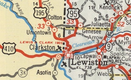
Maps from the earliest years of the US highway system show that both US 195 and US 410 terminated in (or at least near) Lewiston:
Get your copy of this epic book that commemorates the first century of the US route system!

Picture
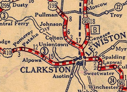
c. 1927, Rand McNally
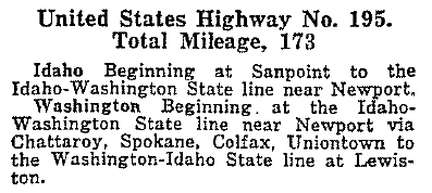
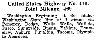
Where exactly did those routes end?  Today the south end of US 195 is about eight miles north of Lewiston, at the top of "the Hill".  But all maps and documentation from the early years indicate that US 195 did not originally end there, instead overlapping with US 95 down the Hill and into the Lewis-Clark Valley.  In fact, the entries in AASHO's earliest route log (from April 1927) suggest that the US 195 and US 410 designations shared a common terminus at the state line on the bridge connecting Lewiston and Clarkston:
Picture
Picture
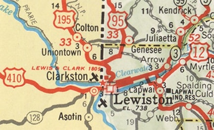
It is unclear whether the routes were ever actually signposted that way.  This is a commercial map from 1933, showing lots of interesting things: the Old Spiral Highway was still the main north-south road; the old bridge over the Clearwater River was still in use; and highway traffic in Clarkston was directed along Diagonal and Chestnut streets (instead of staying on Bridge Street).  But one thing this map does not make clear is exactly where US 410 ended and US 195 began:
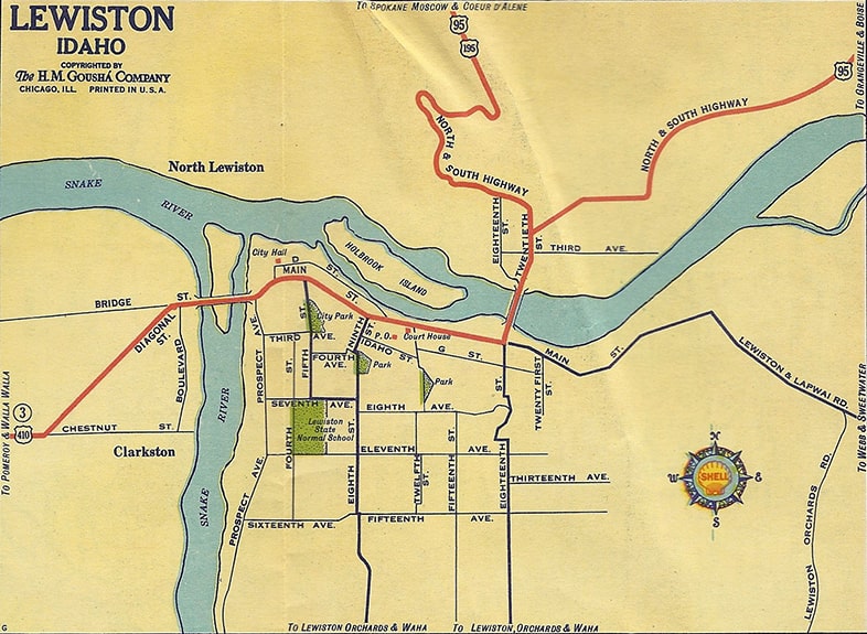
Picture
c. 1933, Gousha
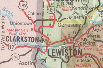
US 95 never went through downtown Lewiston.  Instead, at the bottom of the Hill in North Lewiston, US 95 makes a sharp turn.  Photos from the 1950s (below) prove that, from that junction, it was eventually US 410 that continued south across the river, then west through downtown Lewiston and crossing into Washington.  The 1948 USGS topo shown here is overlaid on top of a modern basemap, which is visible on the right edge, allowing us to reference the location of today's US 12-95 interchange:
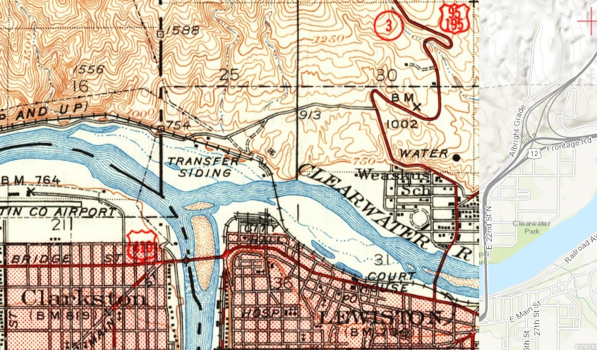
Picture
c. 1948, USGS
Despite the fact that both of those maps indicated that US 195 continued down the Hill into Lewiston, all photos that I have seen do not indicate that US 195 was actually signposted that far south.  We will start with this one, which was taken looking southwest on what is now Old North-South Highway, at its junction with Downriver Road:
Picture
c. 1955 (linked to source)
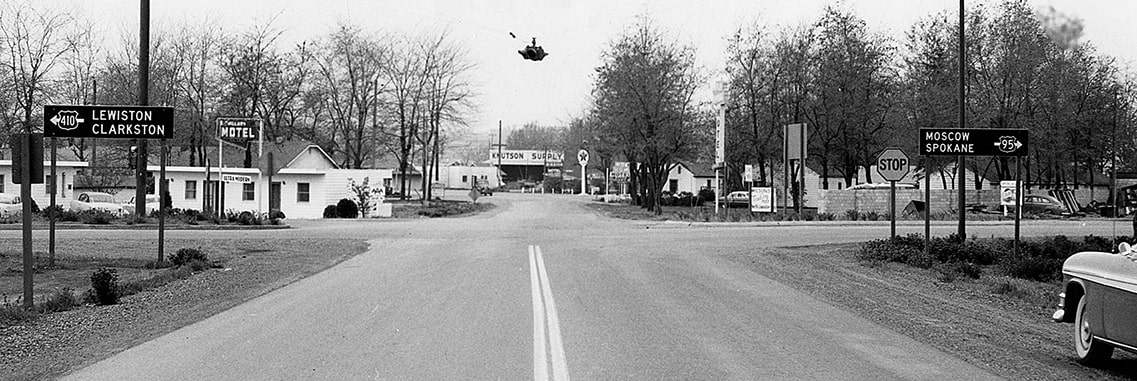
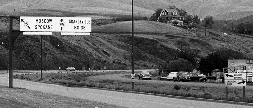
At the time that was northbound US 95, which continued to the right; note that there was no indication of US 195 in that direction.  To the left on Downriver was the east beginning of US 410... although not the original beginning.  By the time of these photos, the Memorial Bridge (the current bridge over the Clearwater River) had been open for a few years.  So from the junction pictured above, US 410 traffic was routed southeast to 22nd Street and the new bridge.  But prior to 1951, there was a different bridge.  It is no longer extant, but it was shown on the maps above, and it connected 18th Street in Lewiston to 20th Street in North Lewiston.  So from 1926 until a few years before the photo above was taken, the beginning of US 410 was straight ahead, curving to the left to merge with 20th St.  This next photo was looking southeast at the same intersection:
Picture
c. 1955 (linked to source)
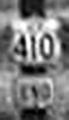
That was southbound US 95, which continued to the left on North-South Hwy.  Straight ahead on Downriver was the east beginning of US 410 (but a few years earlier, US 410 began to the right).  The sign visible at left is enlarged below:
Picture
(detail)
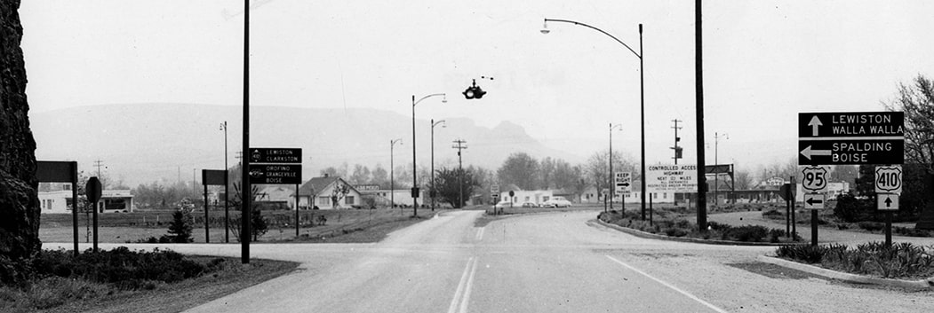
The photo below was looking north along 22nd in North Lewiston just a couple years after the Memorial Bridge opened, so it shows the original signage that was posted when that road first opened to traffic:
Picture
c. 1953 (linked to source)
Again, note that the road towards Spokane was marked only US 95, no mention of US 195.  In the center of that photo is a street lamp post, and towards its base was a sign assembly reading "US 410 END", enlarged here:
Picture
(detail)

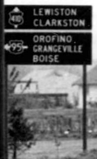
Within a year or two after that photo was taken, signage at that junction was replaced, as shown in this outstanding photo from roughly the same vantage point:
Picture
c. 1955 (linked to source)

This photo shows a US 410 shield looking east on Main, as viewed from the east end of the Interstate Bridge over the Snake River from Clarkston:
Picture
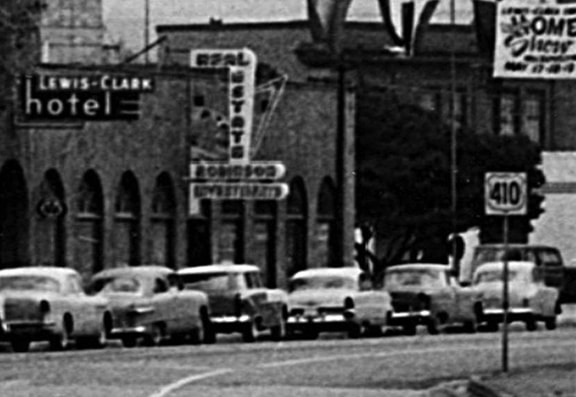
c. May 1957 (linked to source)
The endpoints for both US 410 and US 195 probably remained in their same locations for up to 40 years:
Picture
c. 1963, Idaho DoT

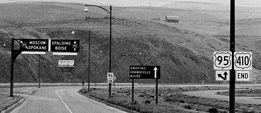
In 1963, the US 12 designation was extended west from Missoula MT, over Lolo Pass.  So for a brief time, three US routes ended in the Lewiston area; US 12 probably ended in North Lewiston, at the same place where US 410 began...
Picture
c. 1964, Idaho DoT
...but that did not last long: in 1967, the US 12 designation was extended west from Lewiston, replacing the former US 410:
Picture
c. 1968, Idaho DoT

This photo shows workmen in the Lewiston area taking down the 410 shields and replacing them with US 12 signs:
Picture
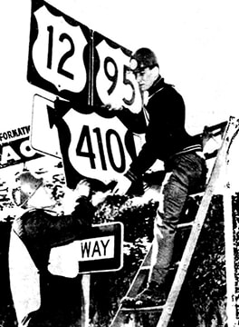
c. Jan. 1968 (linked to source)
So since 1967, only one US route has an endpoint in the Lewiston area.  Again, it is unclear whether the US 195 designation ever went all the way down the Hill into Lewiston, and if so, when it was truncated to its current terminus.  But if it ever went into Lewiston, the photos on this page suggest that it had already been truncated by the 1950s. 

In the mid-1970s, US 95 traffic was moved off what is now known as the Old Spiral Highway, and onto its current four-lane grade up the Hill.  At the top of the Hill, a new bridge over Hatwai Creek was built, such that US 95 now stays entirely within Idaho (the original US 95 crossed Hatwai Creek a little further upstream, so there was a one-mile segment that passed in and out of Washington).  At that time, US 195 was lengthened slightly along what had been US 95, terminating at its junction with the new US 95.
main US 12 page
Main US 195 page
main US 410 page
Research and/or photo credits: Mark Bozanich; Mike Roberson; Dale Sanderson
Page originally created 2001;
last updated Dec. 16, 2021.
Copyright © 1998-2025
Picture