US Ends .com
  • Home
  • Store
    • US highway book
    • US highway map
    • Florida US highway map
  • Endpoints
    • US 1 - US 9 >
      • 1 >
        • 201
        • 301
        • 401 [i]
        • 401 [ii]
        • 401
        • 501
        • 601
        • 701
      • 2w >
        • 102
      • 2e >
        • 202
        • 302
      • 3
      • 4 >
        • 104
      • 5
      • 6 >
        • 106
        • 206
      • 7
      • 8
      • 9 >
        • 109*
        • 209
        • 309
    • US 10 - US 19 >
      • 10 >
        • 110
        • 210
        • 310
        • 410
      • 11 >
        • 111
        • 211
        • 311
        • 411 [i]
        • 411 [ii]
        • 411
        • 511*
        • 611
        • 711*
      • 12 >
        • 112
        • 212
        • 312
      • 13 >
        • 113
        • 213
      • 14
      • 15
      • 16 >
        • 116
        • 216
      • 17 >
        • 17-1
        • 117 [i]
        • 117
        • 217
      • 18 >
        • 118
        • 218
      • 19 >
        • 119
        • 219
        • 319
    • US 20 - US 29 >
      • 20e >
        • 120
        • 220
        • 320
        • 420
      • 20w
      • 21 >
        • 121 [i]
        • 121
        • 221
        • 321
        • 421
        • 521
      • 22 >
        • 122 [i]
        • 122 [ii]
        • 222
        • 322
        • 422e
        • 422w
        • 522
        • 622*
      • 23 >
        • 123 [i]
        • 123
        • 223
      • 24 >
        • 124
        • 224
      • 25
      • 26 >
        • 126
      • 27 >
        • 127
        • 227
      • 28
      • 29 >
        • 129
    • US 30 - US 39 >
      • 30 >
        • 130
        • 230
        • 330
        • 430
        • 530
        • 630*
        • 730
        • 830
      • 31 >
        • 131
        • 231
        • 331 [i]
        • 331
        • 431
      • 32
      • 33
      • 34
      • 35
      • 36 >
        • 136
      • 38 >
        • 138
    • US 40 - US 49 >
      • 40 >
        • 140
        • 240
        • 340
      • 41 >
        • 141
        • 241 [i]
        • 241 [ii]
        • 341
        • 441 >
          • 441n
          • 441s
        • 541
        • 641
      • 42
      • 43
      • 44
      • 45
      • 46
      • 48 [i]
      • 48 [ii]
      • 48
      • 49
    • US 50 - US 59 >
      • 50 >
        • 150
        • 250
        • 350
        • 450
        • 550
        • 650
      • 51 - 55 >
        • 51 >
          • 151
        • 52 >
          • 152
        • 53
        • 54 >
          • 154
        • 55
      • 56 >
        • 156
      • 57
      • 58 >
        • 158
        • 258
      • 59 >
        • 159
        • 259
    • US 60 - US 69 >
      • 60 >
        • 160
        • 260
        • 360
        • 460
      • 61 - 65 >
        • 61 >
          • 161
        • 62
        • 63 >
          • 163 [i]
        • 64 >
          • 164 [i]
          • 164 [ii]
          • 264
        • 65 >
          • 165
      • 66 >
        • 166
        • 266
        • 366 [i]
        • 366 [ii]
        • 466 [i]*
        • 466 [ii]
        • 566
        • 666
      • 67 >
        • 167
      • 68 >
        • 168
      • 69 >
        • 169
    • US 70 - US 79 >
      • 70 >
        • 170
        • 270 [i]*
        • 270
        • 370
        • 470
      • 71 >
        • 171
        • 271
        • 371 [i]
        • 371 [ii]
        • 371
      • 72 - 76 >
        • 72
        • 73
        • 74
        • 75 >
          • 175
          • 275
        • 76 >
          • 176
          • 276
      • 77 >
        • 177
        • 277
        • 377
      • 78 >
        • 178
        • 278
        • 378
      • 79
    • US 80 - US 89 >
      • 80 - 84 >
        • 80 >
          • 180 [i]
          • 180
          • 280
          • 380
        • 81 >
          • 181
          • 281
        • 82
        • 83 >
          • 183
          • 283
          • 383
        • 84
      • 85 - 89 >
        • 85 >
          • 185
          • 285 [i]
          • 285
          • 385 [i]
          • 385
          • 485
        • 87 >
          • 187
          • 287n
          • 287s
        • 89n
        • 89s >
          • 189 [i]
          • 189
    • US 90 - US 99 >
      • 90 - 94 >
        • 90 >
          • 190
          • 290
        • 91 >
          • 191 >
            • 191n
            • 191s
          • 491
        • 92 >
          • 192
        • 93
        • 94
      • 95 -98 >
        • 95 >
          • 195
          • 295
          • 395
        • 96 [i]
        • 96
        • 97 >
          • 197
        • 98
      • 99 >
        • 199
        • 299
        • 399
    • Anomalies >
      • 101
      • 163
      • 400
      • 412
      • 425
  • Places
    • A-L >
      • A >
        • Aberdeen
        • Albuquerque
        • Amarillo
        • Apalachicola
        • Astoria
        • Atlantic
      • B >
        • Baltimore
        • Baton Rouge
        • Bay Area
        • Bishop
        • Boone
        • Brady
        • Bristol
        • Brownsville
        • Brunswick
      • C >
        • Charleston
        • Chattanooga
        • Chicago
        • Cincinnati
        • Cleveland
        • Cody
        • Corpus
        • Cortez
        • Council Bluffs
        • Covington
        • Crescent
        • Cumberland Gap
      • D-E >
        • Dallas
        • Des Moines
        • Detroit
        • Dothan
        • Douglas
        • El Paso
        • Erie
        • Eugene
      • F >
        • Farmington
        • Flagstaff
        • Florence
        • Fox Valley
        • Franklin
      • G >
        • Gallup
        • Georgetown
        • Grand Junction
        • Grand Portage
        • Grayling
        • Great Falls
        • Greeley
      • H-I >
        • Hardeeville
        • Harrisburg
        • Holbrook
        • Idaho Falls
        • Int'l Falls
      • J-K >
        • Jacksonville
        • Joplin
        • Junction
        • Kansas City
        • Keokuk
        • Key West
        • Kingman
      • L >
        • Laredo
        • Lewiston
        • Long Beach
        • Los Angeles
        • Louisville
        • Lubbock
    • M-R >
      • M >
        • Mackinaw
        • Madison
        • Maryhill
        • Maysville
        • Miami
        • Midway
        • Miles City
        • Milford
        • Milwaukee
        • Minneapolis
        • Mobile 31
        • Mobile 31-43-45
        • Montgomery
        • Monticello
        • Mount Vernon
      • N-O >
        • Nags Head
        • Naples
        • Natchez
        • New Castle
        • New Orleans
        • Niagara
        • Norlina
        • Ocean City
        • Oklahoma City
      • P >
        • Pee Dee
        • Pembina
        • Pensacola
        • Petersburg
        • Philadelphia
        • Piegan
        • Pineville
        • Port Arthur
        • Portsmouth
      • Q-R >
        • Quad Cities
        • Rapid City
        • Raton
        • Reading
        • Richmond
        • Rockingham
        • Rouses Point
    • S-Z >
      • S >
        • San Antonio
        • San Antonio NM
        • San Diego
        • Santa Fe
        • Savannah
        • Sioux
        • Springer
        • Springfield
        • St. Ignace
        • St. John
        • St. Paul
        • St. Pete
      • T-U-V >
        • Tallahassee
        • Tampa
        • Toledo
        • Trinidad
        • Tuba City
        • Ucolo
        • VA Beach
      • W >
        • Walterboro
        • Waverly
        • West Memphis
        • Wilmington
        • Wilson
        • Wrightsville
      • Y >
        • Yellowstone E
        • Yellowstone N
        • Yellowstone NE
        • Yellowstone S
        • Yellowstone W
  • Highways
    • Map of all endpoints
    • Sources
    • History
    • 1926 almost-routes
    • Intra-state routes
    • Numbering
    • Colors
    • Gaps
    • Blog
  • Bonus
    • Colorado >
      • Lowest point
      • Antipodes
      • Toponymy >
        • Roots
      • Colloquialisms
      • Populations
      • Denvers
    • Washington Meridian
    • Watersheds >
      • Headwaters Hill
      • Three Waters Mtn.
      • Parting of the Waters
    • Geo-centers >
      • 48 states
      • 50 states
      • North America
    • State corners >
      • AZ-CO-NM-UT
      • CO-UT-WY
      • CO-NE-WY
      • CO northeast
      • CO-KS-NE
      • CO-KS-OK
      • CO-NM-OK
      • NM-OK-TX
      • NM southeast
      • TX northwest
  • Connect
    • Author/history
    • Rationale
    • Contact
    • Contributors
    • Submissions

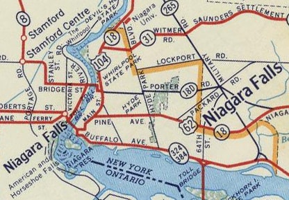
US highway endpoints in Niagara Falls, NY

1932-present
Get your very own map showing all current and historic US routes!

The US 62 designation was extended to Niagara Falls in 1932.  US 62 is routed north out of Buffalo on Niagara Falls Blvd.  By the time that road reaches Niagara, it is heading pretty much due west.  About two miles before its north end, US 62 originally followed what is now Business 62, or Pine Avenue:
Picture
c. 1956, Gousha
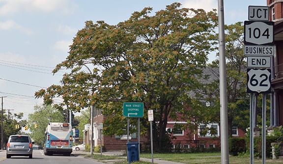
The US 104 designation was created two years later (1934), with its west terminus in Niagara.  Today Business 62 ends at its junction with Main, and the preceding map suggests that mainline US 62 could have ended there too, at its junction with US 104 (now NY hwy. 104):
Picture
Nitzman, Aug. 2021
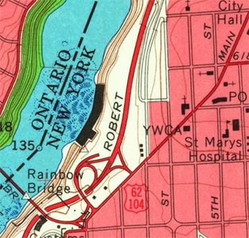
Since the City Hall is at that intersection, it is possible that mainline US 62 could have ended there historically, and that notion is not ruled out by this early topo map:
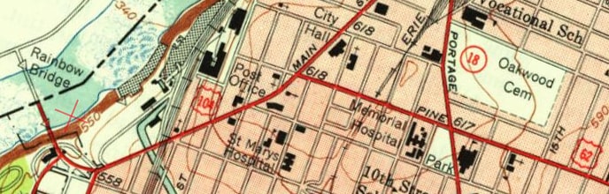
Picture
c. 1949, USGS
Get your copy of this epic book that commemorates the first century of the US route system!

This photo was looking north on Main at Pine; originally US 62 may have begun to the right:
Picture
Nitzman, Aug. 2021
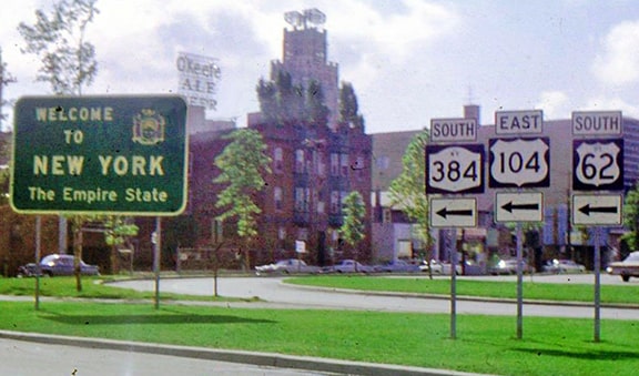
However, it would have made sense for US 62 to be signed all the way to the international bridge to Canada (which was the Honeymoon Bridge until 1938, replaced by the Rainbow Bridge in 1941).  And at some point that did happen: USGS maps from 1965, 1980, and 1995 all show US 62 on Main to the Bridge...
Picture
c. 1965, USGS
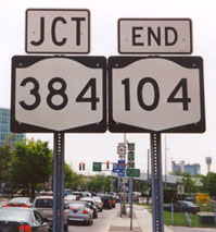
...and this photo proves that at one time both routes were signed at the border crossing:
Picture
c. 1970? (attribution unknown)
This photo was looking south on Main Street, where it splits into Rainbow Boulevard and meets Niagara Street:
Picture
Nitzman, 2000
Just to the right is a junction with Robert Moses Parkway, and then the toll bridge across to Canada, just downstream from the famous waterfalls.  Today the north beginning of US 62 is about a block behind the camera, but this was probably its original endpoint, and likely for decades US 62 overlapped with US 104 to a common endpoint there.  Nearby was the interesting sign shown here:
Picture
Nitzman, 2000 (unchanged as of July 2006)
Picture
Nitzman, Aug. 2021
​That was on northbound 2nd Avenue.  A hard right put drivers onto the north beginning of US 62, while going a bit further and taking an easy right put one at the east beginning of what was formerly US 104.  

​This shot was looking west on Niagara Street; straight ahead is customs for the Rainbow Bridge crossing to Niagara Falls, Ontario.  To the right on Main was historically the north beginning of US 62 and the west beginning of US 104:
Picture
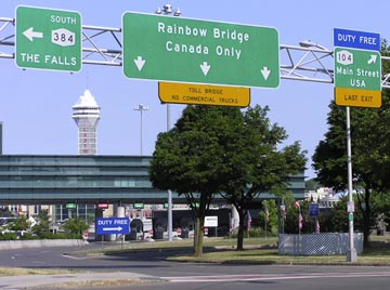
Elbert, Jul. 2006 (384 sign since removed)
In the 1960s, the two blocks to the south of Pine (Walnut Avenue and Ferry Avenue) were extended east to intersect Pine/US 62, and in the 1970s US 62 traffic was rerouted to follow these one-way roads.  (Initially Pine was re-designated as NY hwy. 62A, but in 2006 it was changed to Business US 62.)  The US 104 designation was replaced by NY 104 in 1971, and that may have been when the US 62 designation was truncated to its current terminus.  At any rate, here is the final northbound sign:
Picture
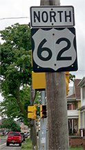
Karner, Jun. 2013 (same as of 2021)
That was posted on Walnut at 7th Street.  About two blocks ahead we reach the north end, which is at the intersection with Main:
Picture
Nitzman, 2000 (same as of July 2006)
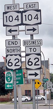
Picture
Karner, June 2013
Picture
Prestley, Jul. 2019
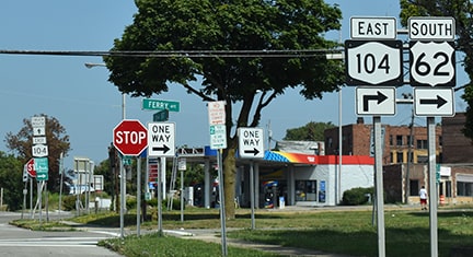
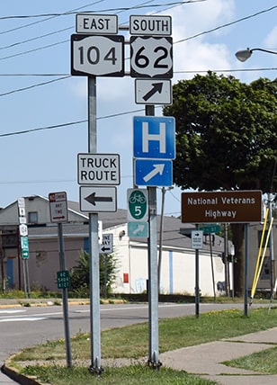
In that first photo, that "US 62A" sign was a mistake: at the time it should have been NY 62A.  But when that designation was changed to Business US 62, what did the replacement sign say?  NY 62.  Kind of funny.  Now the signage is correct, except the "Business" and "TO" tabs should be switched.  But I digress: at least there is an "End" sign at US 62's northern terminus.  This shot was looking north on Main (or east on NY 104).  To the right is eastbound Ferry Avenue, which is the north beginning of US 62:
Picture
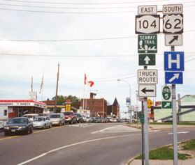
Nitzman, 2000 ("Seaway Trail" signage gone by 2013)
Picture
Nitzman, Aug. 2021
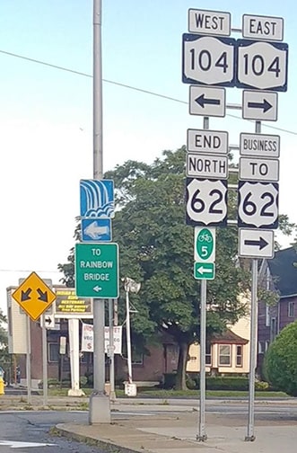
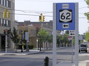
The traffic light in the background is Walnut, the north end of US 62.  If a driver takes that right turn onto Ferry, they will soon see the first southbound US 62 marker:
Picture
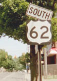
Morrison, Aug. 2002 (unchanged as of 2006)
Picture
Nitzman, Aug. 2021
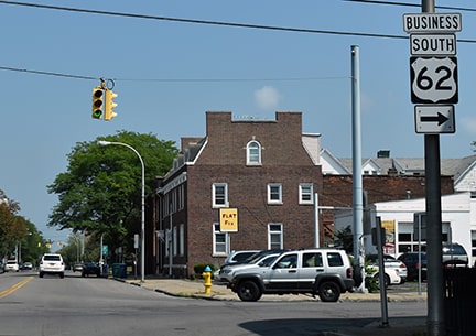
​Below is a photo from southbound Main:
Picture
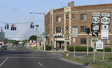
Elbert, Jul. 2006 (104 sign gone as of 2021)
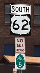
There, signs do not direct traffic all the way to Ferry Av.  Instead, that left turn takes one south on 3rd Street, and then at the Ferry intersection drivers encounter the sign shown here: 
Picture
Elbert, July 2006
Of course that is actually US 62 (not NY 62), but that appears to be a common problem with signs in this area.
main US 62 page
main US 104 page
Research and/or photo credits: Chris Elbert; Martin Karner; Jeff Morrison; Alex Nitzman; Robert Prestley; Dale Sanderson; Michael Summa
Page originally created 1999;
last updated Oct. 14, 2021.
Copyright © 1998-2025
Picture