US Ends .com
  • Home
  • Store
    • US highway book
    • US highway map
    • Florida US highway map
  • Endpoints
    • US 1 - US 9 >
      • 1 >
        • 201
        • 301
        • 401 [i]
        • 401 [ii]
        • 401
        • 501
        • 601
        • 701
      • 2w >
        • 102
      • 2e >
        • 202
        • 302
      • 3
      • 4 >
        • 104
      • 5
      • 6 >
        • 106
        • 206
      • 7
      • 8
      • 9 >
        • 109*
        • 209
        • 309
    • US 10 - US 19 >
      • 10 >
        • 110
        • 210
        • 310
        • 410
      • 11 >
        • 111
        • 211
        • 311
        • 411 [i]
        • 411 [ii]
        • 411
        • 511*
        • 611
        • 711*
      • 12 >
        • 112
        • 212
        • 312
      • 13 >
        • 113
        • 213
      • 14
      • 15
      • 16 >
        • 116
        • 216
      • 17 >
        • 17-1
        • 117 [i]
        • 117
        • 217
      • 18 >
        • 118
        • 218
      • 19 >
        • 119
        • 219
        • 319
    • US 20 - US 29 >
      • 20e >
        • 120
        • 220
        • 320
        • 420
      • 20w
      • 21 >
        • 121 [i]
        • 121
        • 221
        • 321
        • 421
        • 521
      • 22 >
        • 122 [i]
        • 122 [ii]
        • 222
        • 322
        • 422e
        • 422w
        • 522
        • 622*
      • 23 >
        • 123 [i]
        • 123
        • 223
      • 24 >
        • 124
        • 224
      • 25
      • 26 >
        • 126
      • 27 >
        • 127
        • 227
      • 28
      • 29 >
        • 129
    • US 30 - US 39 >
      • 30 >
        • 130
        • 230
        • 330
        • 430
        • 530
        • 630*
        • 730
        • 830
      • 31 >
        • 131
        • 231
        • 331 [i]
        • 331
        • 431
      • 32
      • 33
      • 34
      • 35
      • 36 >
        • 136
      • 38 >
        • 138
    • US 40 - US 49 >
      • 40 >
        • 140
        • 240
        • 340
      • 41 >
        • 141
        • 241 [i]
        • 241 [ii]
        • 341
        • 441 >
          • 441n
          • 441s
        • 541
        • 641
      • 42
      • 43
      • 44
      • 45
      • 46
      • 48 [i]
      • 48 [ii]
      • 48
      • 49
    • US 50 - US 59 >
      • 50 >
        • 150
        • 250
        • 350
        • 450
        • 550
        • 650
      • 51 - 55 >
        • 51 >
          • 151
        • 52 >
          • 152
        • 53
        • 54 >
          • 154
        • 55
      • 56 >
        • 156
      • 57
      • 58 >
        • 158
        • 258
      • 59 >
        • 159
        • 259
    • US 60 - US 69 >
      • 60 >
        • 160
        • 260
        • 360
        • 460
      • 61 - 65 >
        • 61 >
          • 161
        • 62
        • 63 >
          • 163 [i]
        • 64 >
          • 164 [i]
          • 164 [ii]
          • 264
        • 65 >
          • 165
      • 66 >
        • 166
        • 266
        • 366 [i]
        • 366 [ii]
        • 466 [i]*
        • 466 [ii]
        • 566
        • 666
      • 67 >
        • 167
      • 68 >
        • 168
      • 69 >
        • 169
    • US 70 - US 79 >
      • 70 >
        • 170
        • 270 [i]*
        • 270
        • 370
        • 470
      • 71 >
        • 171
        • 271
        • 371 [i]
        • 371 [ii]
        • 371
      • 72 - 76 >
        • 72
        • 73
        • 74
        • 75 >
          • 175
          • 275
        • 76 >
          • 176
          • 276
      • 77 >
        • 177
        • 277
        • 377
      • 78 >
        • 178
        • 278
        • 378
      • 79
    • US 80 - US 89 >
      • 80 - 84 >
        • 80 >
          • 180 [i]
          • 180
          • 280
          • 380
        • 81 >
          • 181
          • 281
        • 82
        • 83 >
          • 183
          • 283
          • 383
        • 84
      • 85 - 89 >
        • 85 >
          • 185
          • 285 [i]
          • 285
          • 385 [i]
          • 385
          • 485
        • 87 >
          • 187
          • 287n
          • 287s
        • 89n
        • 89s >
          • 189 [i]
          • 189
    • US 90 - US 99 >
      • 90 - 94 >
        • 90 >
          • 190
          • 290
        • 91 >
          • 191 >
            • 191n
            • 191s
          • 491
        • 92 >
          • 192
        • 93
        • 94
      • 95 -98 >
        • 95 >
          • 195
          • 295
          • 395
        • 96 [i]
        • 96
        • 97 >
          • 197
        • 98
      • 99 >
        • 199
        • 299
        • 399
    • Anomalies >
      • 101
      • 163
      • 400
      • 412
      • 425
  • Places
    • A-L >
      • A >
        • Aberdeen
        • Albuquerque
        • Amarillo
        • Apalachicola
        • Astoria
        • Atlantic
      • B >
        • Baltimore
        • Baton Rouge
        • Bay Area
        • Bishop
        • Boone
        • Brady
        • Bristol
        • Brownsville
        • Brunswick
      • C >
        • Charleston
        • Chattanooga
        • Chicago
        • Cincinnati
        • Cleveland
        • Cody
        • Corpus
        • Cortez
        • Council Bluffs
        • Covington
        • Crescent
        • Cumberland Gap
      • D-E >
        • Dallas
        • Des Moines
        • Detroit
        • Dothan
        • Douglas
        • El Paso
        • Erie
        • Eugene
      • F >
        • Farmington
        • Flagstaff
        • Florence
        • Fox Valley
        • Franklin
      • G >
        • Gallup
        • Georgetown
        • Grand Junction
        • Grand Portage
        • Grayling
        • Great Falls
        • Greeley
      • H-I >
        • Hardeeville
        • Harrisburg
        • Holbrook
        • Idaho Falls
        • Int'l Falls
      • J-K >
        • Jacksonville
        • Joplin
        • Junction
        • Kansas City
        • Keokuk
        • Key West
        • Kingman
      • L >
        • Laredo
        • Lewiston
        • Long Beach
        • Los Angeles
        • Louisville
        • Lubbock
    • M-R >
      • M >
        • Mackinaw
        • Madison
        • Maryhill
        • Maysville
        • Miami
        • Midway
        • Miles City
        • Milford
        • Milwaukee
        • Minneapolis
        • Mobile 31
        • Mobile 31-43-45
        • Montgomery
        • Monticello
        • Mount Vernon
      • N-O >
        • Nags Head
        • Naples
        • Natchez
        • New Castle
        • New Orleans
        • Niagara
        • Norlina
        • Ocean City
        • Oklahoma City
      • P >
        • Pee Dee
        • Pembina
        • Pensacola
        • Petersburg
        • Philadelphia
        • Piegan
        • Pineville
        • Port Arthur
        • Portsmouth
      • Q-R >
        • Quad Cities
        • Rapid City
        • Raton
        • Reading
        • Richmond
        • Rockingham
        • Rouses Point
    • S-Z >
      • S >
        • San Antonio
        • San Antonio NM
        • San Diego
        • Santa Fe
        • Savannah
        • Sioux
        • Springer
        • Springfield
        • St. Ignace
        • St. John
        • St. Paul
        • St. Pete
      • T-U-V >
        • Tallahassee
        • Tampa
        • Toledo
        • Trinidad
        • Tuba City
        • Ucolo
        • VA Beach
      • W >
        • Walterboro
        • Waverly
        • West Memphis
        • Wilmington
        • Wilson
        • Wrightsville
      • Y >
        • Yellowstone E
        • Yellowstone N
        • Yellowstone NE
        • Yellowstone S
        • Yellowstone W
  • Highways
    • Map of all endpoints
    • Sources
    • History
    • 1926 almost-routes
    • Intra-state routes
    • Numbering
    • Colors
    • Gaps
    • Blog
  • Bonus
    • Colorado >
      • Lowest point
      • Antipodes
      • Toponymy >
        • Roots
      • Colloquialisms
      • Populations
      • Denvers
    • Washington Meridian
    • Watersheds >
      • Headwaters Hill
      • Three Waters Mtn.
      • Parting of the Waters
    • Geo-centers >
      • 48 states
      • 50 states
      • North America
    • State corners >
      • AZ-CO-NM-UT
      • CO-UT-WY
      • CO-NE-WY
      • CO northeast
      • CO-KS-NE
      • CO-KS-OK
      • CO-NM-OK
      • NM-OK-TX
      • NM southeast
      • TX northwest
  • Connect
    • Author/history
    • Rationale
    • Contact
    • Contributors
    • Submissions

End of historic US highway 260
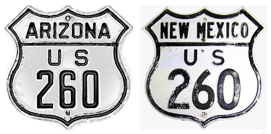
View a map showing this route.
Get your very own map showing all current and historic US routes!
Picture
Summa
1931-1935
  • East: Springerville, AZ
  • West: Holbrook, AZ
1935-1961
  • East: Deming, NM
  • West: Holbrook, AZ
At its maximum extent, US 260 measured approx. 290 miles in total length.
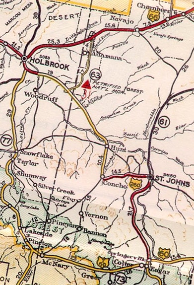
Get your copy of this epic book that commemorates the first century of the US route system!

Picture
c. 1935, AZ DoT
In the original 1926 route plan, it was US 70 that began at US 66 in Holbrook and headed east.  But in 1931, US 70 was drastically rerouted, far to the south of Holbrook.  So US 260 was commissioned to replace the former US 70 starting at Holbrook. 

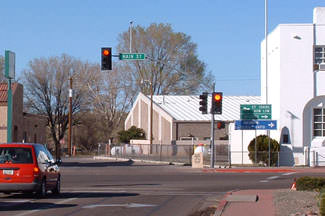
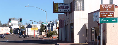
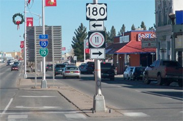
​Originally the east end of US 260 was in Springerville, at the junction with its implied "parent" route, US 60.  During this timeframe, however, US 60's current route between Springerville and Globe was under construction and not yet open to traffic.  So from Globe, US 60 traffic was directed along what must have been an incredibly hellish road back in the 1930s: west to San Carlos; north and west to Ft. Apache; north along today's AZ hwy. 73 to McNary; and west along today's AZ 260 to Eagar.  In Eagar, US 60 was directed north on Mountain Avenue, until reaching the junction with Main Street Springerville:
Picture
Faye and Sandy, Mar. 2007
Picture
Faye and Sandy, Mar. 2007
There, eastbound US 60 traffic was directed to the right on Main, but to the left was the east beginning of US 260.
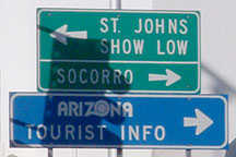
US 260 went through St. Johns on its way to US 66 at Holbrook.  These photos show the perspective at the historic east end of US 260, looking east on Main.  Straight ahead was eastbound US 60, while westbound was to the right on Mountain:
Picture
Faye and Sandy, Mar. 2007
Picture
Faye and Sandy, Mar. 2007
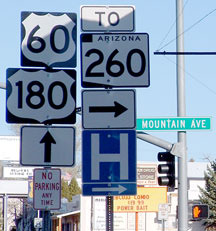
Today Main carries US 60-180-191, but they neglected to sign US 191 on that post.  After modern US 60 was complete between there and Globe, old US 60 (to the right on Mountain) was signed as AZ 260.  But today mainline AZ 260 is signed along Central Avenue in Eagar, the junction with which is about 1.5 miles to the right.
Picture
c. 1937, NM DoT
It was not long before US 260 was extended southward out of Springerville; this photo was taken looking that direction, only about four years after the east end of US 260 had been extended down to US 70-80 at Deming:
Picture
Lee, c. 1940 (detail; Library of Congress photo)
US 260 came into Deming via Gold Avenue; its final resting place in was at Pine Street (which carries Business I-10)...
...but for the majority of its existence, US 260 continued one block further ahead, ending at Spruce Street:
DSCN6690
DSCN6692
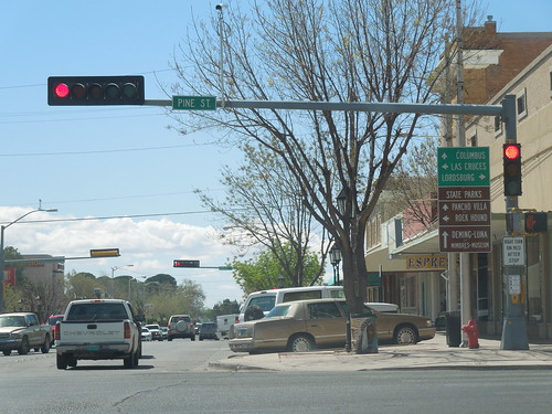
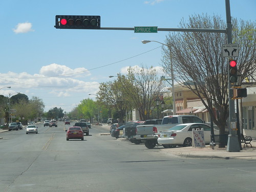
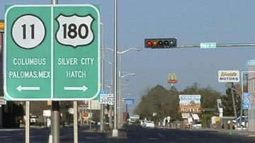
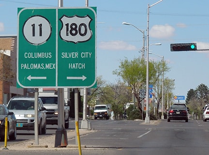
This image was taken looking west on Spruce.  Originally US 70-80 traffic was directed to use Spruce through town.  So Deming's first US 260 terminus was to the right on Gold...
DSCN6724
...but at some point, US 70-80 traffic was moved to Pine Street, which runs one block to the north (right).  ​The photo from this old postcard was taken looking east on Pine, back when US 260 began to the left on Gold:
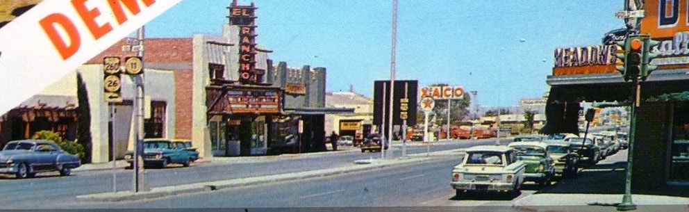
Picture
attribution unknown
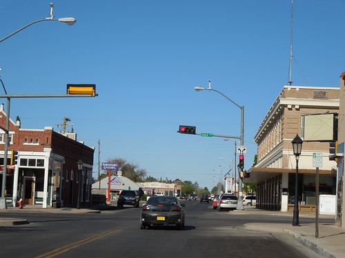
In 1961, the US 180 designation was extended west from its former terminus in El Paso.  It was (and still is) overlapped with other routes along the entire distance between El Paso and Deming.  Then the designation heads north out of Deming -- it goes all the way up to Holbrook, and then beyond (to the Grand Canyon), so that is how the US 260 designation became unnecessary and was eliminated.  These more recent shots were looking the same direction:
Picture
Hamilton, Aug. 2000
Picture
Karners, Dec. 2011
The rationale for that change is unclear: the El Paso-to-Deming corridor already had a route number, so what was the purpose in having US 180 make a sharp change in direction at El Paso just to get to Deming, over 100 miles distant?  Would it not have made more sense to simply extend the US 260 designation west from Holbrook to the Grand Canyon?  Maybe AASHTO wanted to conserve route numbers... but US 260 has never been recycled.  Or maybe Arizona wanted the number "260" for one of its state routes... but they could have come up with an equally valid number.
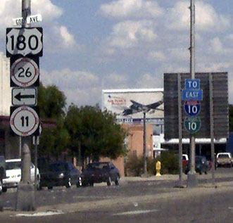
At any rate, these photos were looking the opposite direction (west on Pine).  Today that is westbound US 70 (and also US 180 and Business I-10); US 260 began to the right:
Picture
Faye and Sandy, Apr. 2006
Picture
Sanderson, Mar. 2016

Research and/or photo credits: Nathan Edgars; Alan Hamilton; Karin and Martin Karner; Russell Lee; Mike Roberson; Dale Sanderson; Faye and Sandy; Michael Summa
Page originally created 2004;
last updated Dec. 3, 2023.
Copyright © 1998-2025
Picture