Historic US highway endpoints in the Albuquerque area, NM
|
Including Willard and Moriarty
1927-1938
|
 |
|
During the nascent years of the US highway system, US 70 ran through New Mexico along what is now US 60. Just west of Willard, US 470 split off to serve Albuquerque by heading north on what is now NM hwy. 41, and then west along today's I-40 corridor:
|
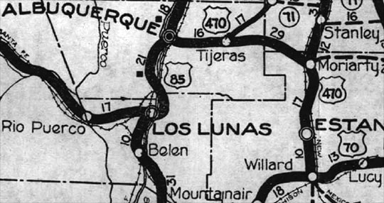
c. 1927, NM DoT
|
|
In 1931, US 70 was rerouted, and its former corridor through Willard became part of an extended US 60. When that happened, the number "470" was no longer appropriate (since the highway no longer connected to US 70)...
|
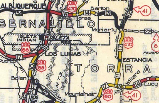
c. 1931, NM DoT
|
|
...so also in 1931 the US 470 designation was changed to US 366, based on its connection to US 66 in Albuquerque (that number had become available because the newly-rerouted US 70 swallowed up the original US 366):
|
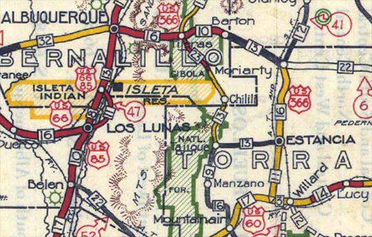
c. 1934, NM DoT
|
|
But then in 1937, US 66 was realigned along a more direct route through New Mexico, taking over what had been US 366 between Albuquerque and Moriarty. That left only a 28-mile segment of US 366 between Moriarty and Willard:
|
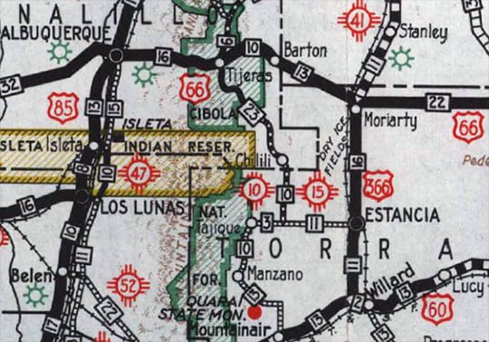
c. 1938, NM DoT
|
...so the next year US 366 was decommissioned, and instead designated as a southern extension of NM 41. These photos were taken in Willard, looking west on US 60 (historically US 70):
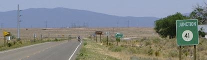
Sanderson, June 2006
|
Sanderson, June 2006
|
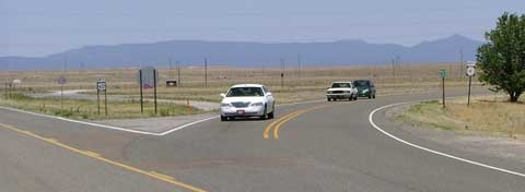
Initially the east beginning of US 470 (and later US 366) was to the right. The white car at the stop sign was at the former east end of US 470-366... or rather, an east end. To clarify, these photos were looking south on NM 41:
Sanderson, June 2006
|
Sanderson, June 2006
|
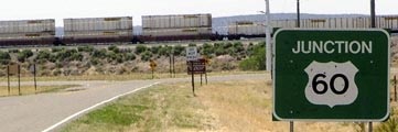
At the time those shots were taken, NM 41 actually had a "Y" intersection with US 60. Mainline US 60 is in the background, running just this side of (and parallel to) the elevated railroad bed. And it is likely that junction was also configured as a "Y" in the 1930s, back when it served as a US highway terminus. If so, then US 470-366 had two east ends: one to the left and one to the right. However, in about 2007, that junction was reconfigured to a more standard "T" intersection.
When US 66 was first commissioned in 1926, it ran north/south through Albuquerque along 4th Street (it was concurrent with US 85 from near Las Vegas NM all the way through Santa Fe and Albuquerque to Los Lunas). Originally, Central Avenue east of 4th was designated US 470, but it was renumbered to US 366 in 1931. In 1937, US 66 was rerouted along a new alignment which bypassed Las Vegas, Santa Fe, and Los Lunas. In other words, it essentially followed the route of today's I-40. In Albuquerque, US 66 traffic was redirected to follow Central Av, thus running through the city in a direction perpendicular to its original route.
|
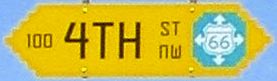
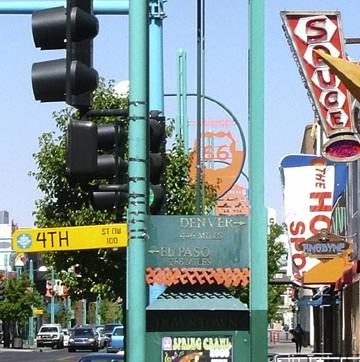
That is a fact not lost on Albuquerque's urban planners: the intersection of these two former alignments (4th and Central) has become "ground zero" for the city's enthusiastic celebration of its fortune to be located on historic route 66. Note the design on the route 66 emblem found on street signs in this area:
|
Sanderson, June 2006
|
|
Note also the art deco typeface used on the street sign -- that was a trendy style during the early years of the US route system. This photo was taken looking north on 4th:
|
Sanderson, June 2006
|
|
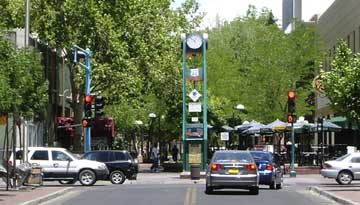
Originally that was northbound US 85/eastbound US 66. To the right on Central was the west beginning of US 470, and later US 366. Today 4th north of Central is not open to vehicle traffic -- it is more of a pedestrian mall. Visible in the photo is the large clock tower that has been installed there. That is something of an outdoor art piece commemorating historic highways in general, and US 66 in particular:
|
Sanderson, June 2006
|
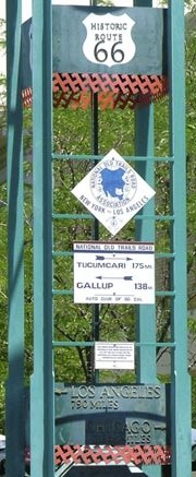
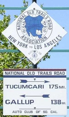
At the bottom, an arrow points left (west) to Los Angeles (790 miles), and right (east) to Chicago (1345 miles). The two signs in the middle are replicas of typical signs that were installed in 1914 by AAA clubs along the National Old Trails Road, which later became US 66:
|
Sanderson, June 2006
|
|
This photo shows the opposite side of the tower (looking south on 4th). From this perspective, US 470-366 began to the left:
|
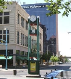
Sanderson, June 2006
|
|
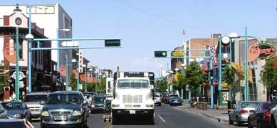
This shot was taken looking west on Central. US 470 (and later US 366) ended at the light (4th):
|
Sanderson, June 2006
|
|
Just to the right of the camera was a "Historic Route" marker:
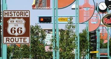
Sanderson, June 2006
Other references to US 66 are also visible in these photos, as is part of the tower in the distance:
|
Sanderson, June 2006
|
From that direction, the arrows point right (north) to Denver (446 miles) and left (south) to El Paso (268 miles). Those are points along "El Camino Real", which later became US 85, but of course that route is not nearly as well-known as US 66.
|
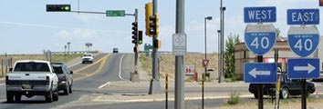
In 1937, US 366 was truncated to Moriarty. Here, we are looking west on historic US 66 (now officially NM hwy. 333):
|
Sanderson, June 2006
|
|
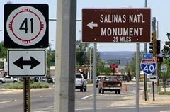
From 1931-1937, US 366 came from the left (via what is now NM hwy. 41) and then continued straight ahead on NM 333. But when US 66 was rerouted along today's NM 333, the north beginning of US 366 was to the left. The view in this photo was northbound on NM 41 at NM 333:
|
Sanderson, June 2006
|
Originally, US 470 (and later US 366) turned left there to serve Albuquerque. But in 1937 that segment became part of US 66, so the trucks in the foreground were at what then became the north end of US 366. (The signage in the foreground was misleading: the quickest way to I-40 is to simply continue ahead to interchange 196. To the left and right is actually Business 40, but poor signage is nothing unusual in New Mexico.) That remaining segment of US 366 was presumably deemed too short to be a US route; it survived for only about one more year before it was completely decommissioned.
Research and/or photo credits: Steve Riner; Dale Sanderson
Page originally created 2005;
last updated Dec. 7, 2023.
last updated Dec. 7, 2023.
