Parting of the Waters
A National Natural Landmark in Wyoming
|
Most people grasp the basic concept of the Great Divide: some watersheds flow eastward to the Atlantic, while other basins flow westward to the Pacific, and the Great Divide is the ridge that separates them. However, when one looks at it more closely, they find that things are a little more complex.
|
|
As it turns out, there are several endorheic (or "closed") basins in the U.S. These are watersheds that have no outlet, and therefore do not drain to any ocean. Conceptually one can think of closed basins as bowls: water flowing from the rim of the bowl down to the inside reaches the lowest point and then has nowhere to go. In a closed basin, the water may pool up in a lake, where it will often evaporate.
|
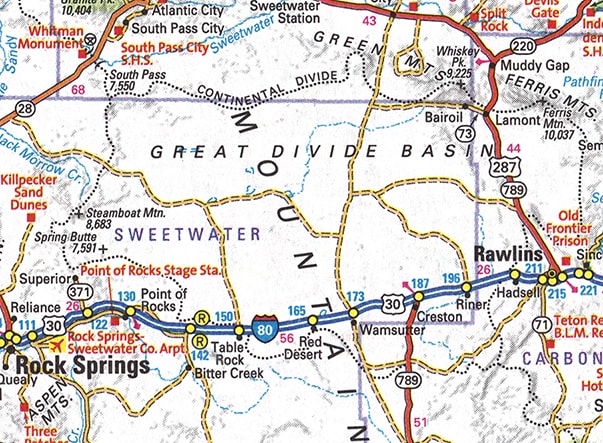
Some closed basins happen to be adjacent to the Great Divide, forming what could be described as bowls or "holes" in the Divide: to the east of the bowl is Atlantic drainage, and water to the west of the bowl flows into the Pacific, but water inside the bowl itself does not drain out at all. Some of these holes are in Wyoming, and one of them -- the "Great Divide Basin" -- is quite well-known, partly because I-80 runs through it between Rock Springs and Rawlins. Alert travelers along this highway might find it curious that they pass two roadsigns marking the Divide. The reason is that they are traveling through a basin that does not drain to any ocean. On this map, the Great Divide is indicated by a thin, dashed, black line running from the upper left corner to the lower right. But in the center of the map, the line splits, going around opposite sides of the Great Divide Basin. Inside those lines is a "hole" that drains only into itself:
|
|
Wyoming has another type of "hole" in the Great Divide: it could be described as the opposite kind of hole from a closed basin. This hole in the Divide is there because of North Two Ocean Creek. This stream flows down from a plateau, and then squarely hits a ridge that forms the summit of Two Ocean Pass. This ridge also happens to be a segment of the Great Divide. Upon hitting this ridge, Two Ocean Creek splits, distributing some of its water down each side of the Divide. This spot is known as the "Parting of the Waters" National Natural Landmark. As far as I know, North Two Ocean Creek is the only stream in the country that sends its water to two oceans. (Some would argue that Isa Lake in Wyoming is similar, but the situation there is not exactly the same as Two Ocean Creek.)
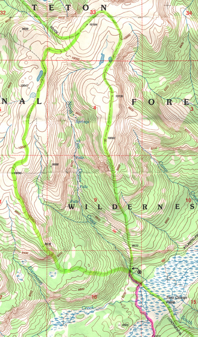
One fork of Two Ocean Creek becomes Pacific Creek: it flows into the Snake River near Moran Jct. in Grand Teton National Park. The Snake eventually flows into the Columbia, which drains into the Pacific Ocean. The other stream is called -- you guessed it -- Atlantic Creek. It flows into the Yellowstone, not far from that river's own headwaters. The Yellowstone is a tributary of the Missouri, which of course flows into the Mississippi and the Atlantic Ocean. In my opinion, an accurate map should show North Two Ocean Creek's entire watershed as a "hole" in the Continental Divide. Not the kind of hole that drains only into itself. But a hole in which any molecule of water may flow into either ocean -- depending simply upon which way it splashes when it hits the Parting of the Waters: |
The basemap is the "Two Ocean Pass" quad from the USGS 7.5 minute series, dated 1996. Their line marking the Continental Divide runs along the east side of North Two Ocean Creek's watershed. I submit that there should also be a line on the west rim. There is no question that any water in this basin will flow to an ocean. However, to which ocean any given drop will flow is arbitrary.
|
I drew in my best estimate of the western limit of the watershed, and I highlighted both lines in green. I also drew the tiny "X" in a circle, which marks the location of the Parting of the Waters. The pink line shows the trail that two of my nephews and I took to see the spot. In this photo, Two Ocean Creek is flowing down from behind the camera. My nephews were standing on the ridge that splits the creek; Rich (on the left) was pointing down Atlantic Creek, and Ken was pointing down Pacific Creek:
|
|
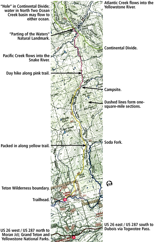
The preceding map shows the entire length of our hike to Two Ocean Pass (the basemap was scanned from the Bridger-Teton National Forest map; I added the highlights and annotation). It was about 30 miles round-trip, which explains why everyone else we saw was on horseback. I don't think I have ever been more exhausted in my life.
Fast-forward about 12 years: a researcher from the British game show QI Presented by Stephen Fry found this web page and contacted me, asking for permission to use some of the photos on their show. I agreed, but then did not hear anything for awhile, so I began to assume nothing would come of it... and even if my photos did get used, I couldn't imagine how I would ever learn about it. However, about six months later one of my colleagues in the US was watching online videos of this UK quiz show, and just happened to recognize me in the photo that shows the sign at the Parting. Thanks to QI, these have turned out to be the most financially-profitable photos in my collection. |
Research and/or photo credits: Dale Sanderson
Page originally created 2002;
last updated Dec. 1, 2016.
last updated Dec. 1, 2016.


