Corner of Arizona-Colorado-New Mexico-Utah
a.k.a. "the Four Corners"
|
According to the Congressional definition of the boundary of Colorado, this point is theoretically where the 37th parallel north latitude intersects 32 degrees west longitude as measured from the Washington Meridian*.
|
|
Notice that definition does not mention anything about 109 degrees west of Greenwich -- this boundary was not defined in reference to today's Prime Meridian. This monument was first set by Chandler Robbins during his 1875 survey -- and due to the technological limitations of his day, it is not exactly in the intended spot. But Robbins' survey was accepted as the border between the states, and his monument was accepted as the point where four state boundaries converge. Today, our ability to more accurately pinpoint where the marker should have been placed is irrelevant, because the legally-accepted location of the Four Corners is exactly where the monument is positioned.
|
* Many American surveys between 1850-1884 were based on the Washington Meridian, which was officially abolished by Congress in favor of the Greenwich Prime Meridian in 1912. "32 degrees west of Washington" is a few miles away from the 109th degree of longitude west of Greenwich.
Note: The book "Colorado Mapology" (Erl H. Ellis, 1983, Jende-Hagan Book Corporation) is an excellent resource, from which I obtained much of the information presented on these pages. The 1908 photos on this page are courtesy of Denver Public Library, Western History Collection. In 1899 this monument was found broken and was reset by Hubert Page and James Lentz; this photo shows what it looked like after that: |
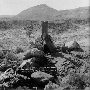
H.S. Poley, 1908 (call number P-1150)
|
|
The text on the photo reads "The Stake at Four Corners Where Colorado-New Mexico-Arizona and Utah Come Together." This is the only point in the U.S. that is common to four states. People have been posing for photos here for a long time, as evidenced by this shot:
|
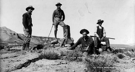
H.S. Poley, 1908 (call number P-1149)
|
|
The view there was to the northwest, so from left to right, the men were in Arizona, Utah, New Mexico, and Colorado. The text at bottom right reads "At Four Corners".
That "stake" was again found broken in 1931, and the monument was rebuilt in concrete by Everett Kimmell. Recognizing the unique character of this location, the Department of the Interior placed a concrete slab around the marker in 1962, and I imagine some of the improvements to the site that we see today took place after that. Here is a photo that was printed on the 1967 official state highway map... |

c. 1967
|
|
...but numerous additional changes to the site have taken place since then. This is undoubtedly the most well-known boundary point in the country, and the most-visited, and probably the only state corner for which visitors must pay an admission fee. The Navajo Nation occupies the corners of three states (all except Colorado, whose corner is part of the Ute Mountain Ute Reservation). A map showing the extent of the Navajo lands is visible on the right side of this photo:
|

Sanderson, July 2004
|
|
On the left side is a close-up view of the area immediately surrounding the monument. That map is oriented with northwest to the top. The road providing access to the monument is NM state highway 597 (a very short spur off US 160), and that is where the Navajo have set up an entrance station to this tribal park. Along the edge of the parking area are all kinds of shops where visitors can buy fry bread and other food, or jewelry and other souvenirs. In other words, this monument provides a striking contrast to the quietness and solitude that one usually finds at almost any other state corner. This photo shows an overview of the monument area:
|
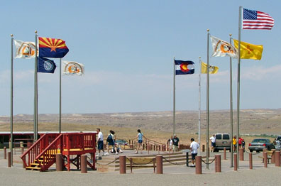
Sanderson, July 2004
|
|
The flags represented there include the four states, as well as four tribal flags. In that view, the camera is on the Arizona/New Mexico line, looking due north. Here is a closer view from the same perspective:
|
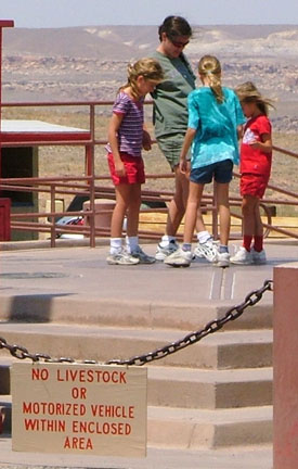
Sanderson, July 2004
|
|
Straight ahead, beginning at the point where the ladies are gathered, that line becomes the boundary between Utah and Colorado. Just be sure you leave your livestock in the car before ascending the platform. Probably the most common photos taken here are of the "four people in four states" theme...
|

Sanderson, July 2004
|
|
...and the "one person in four states" theme:
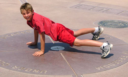
Sanderson, July 2004
|
In the center of that circle can be seen the metal plate that marks the actual point where the four states converge:

Sanderson, July 2004
|
Research and/or photo credits: Dale Sanderson
Page originally created 2003;
last updated Nov. 17, 2016.
last updated Nov. 17, 2016.
