End of US highway 66 |
 |
Summa
|
Summa
|
|
1926-1935
|
1935-1963
|
1963-1972
|
|
1972-1974
|
1974-1979
|
1979-1985
|
|
Note: this page contains information about the mileage of US 66 during some of those timeframes, and the shifting location of its midpoint during those years.
|
|
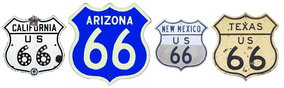
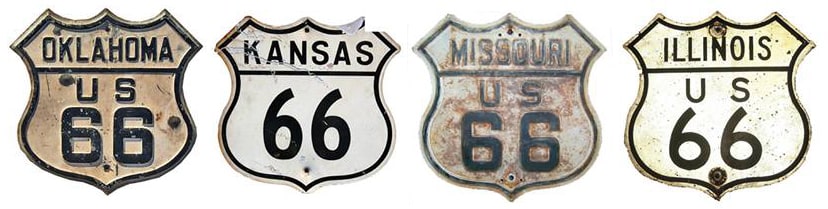
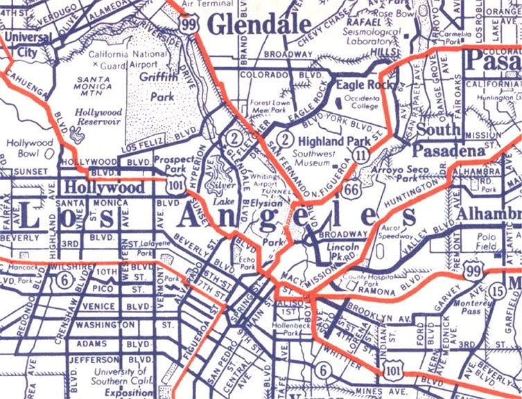
"Route 66" is the most famous of all the US highways. It was officially decommissioned in 1985, but that had the unexpected effect of increasing public awareness of the old "Mother Road". It has since enjoyed tremendous popularity, and many segments of its historic alignments are signed with "Historic Route 66" markers. This map showing the original extent of US 66 was included in a 1931 US Dept. of Agriculture Office of Information press release, issued shortly after the US routes were commissioned:
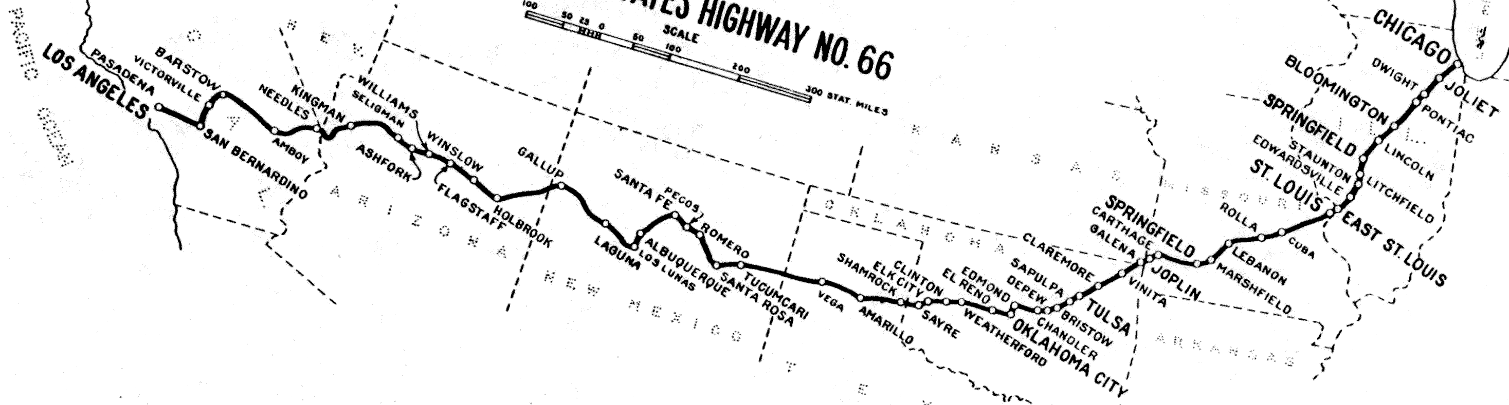
c. 1927, US Government Printing Office
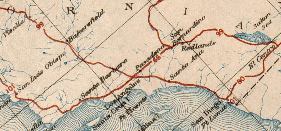
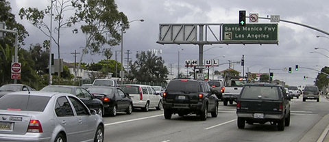
At the time, Los Angeles was the western terminus, but a few years later US 66 was extended to Santa Monica. Route 66 is popular across a broad spectrum, so wouldn't it be lovely if all of its terminus points had a nice, clean history that is easy to comprehend?
If only.
For about 50 years the east end of US 66 was in Chicago. Those endpoints were a little messy, but that was nothing compared to US 66's Los Angeles/SoCal endpoints. I am going to go pretty deep into this topic, because there are a lot of people who are interested in Route 66 and who want to know the facts. But I am also aware that many people are not going to want to wade through all the details below, so I will make it easy by starting out with a simple timeline of US 66's various western endpoints over the years:
But now some questions arise, such as: where does that information come from? And what about the conventional wisdom that US 66 ended at 7th and Broadway in downtown Los Angeles? The answers are all part of a very long story. Where to begin? I think we need to start with the various organizations that were involved, and the types of decisions they were authorized (and not authorized) to make.
If only.
For about 50 years the east end of US 66 was in Chicago. Those endpoints were a little messy, but that was nothing compared to US 66's Los Angeles/SoCal endpoints. I am going to go pretty deep into this topic, because there are a lot of people who are interested in Route 66 and who want to know the facts. But I am also aware that many people are not going to want to wade through all the details below, so I will make it easy by starting out with a simple timeline of US 66's various western endpoints over the years:
- 4 years (Nov. 1926 - Jan. 1931): authorized to Los Angeles, but the specific endpoint was undefined and the route was not signposted anywhere in L.A.
- 4 months (Jan. 1931 - May 1931): signposted to Santa Monica (S.M. Boulevard at Ocean Avenue) but this terminus was not authorized.
- 8 months? (May 1931 - Jan. 1932?): authorized and signposted to Los Angeles (Fletcher Drive at San Fernando Road, jct. US 99).
- 4.5 years (Jan. 1932? - Jun. 1935): authorized and signposted to Los Angeles (Broadway at Sunset Boulevard, jct. US 101).
- 28 years (Jun. 1935 - 1963): authorized and signposted to Santa Monica (Lincoln Boulevard at Olympic Boulevard, jct. US 101A).
- 9 years (1963 - 1972): designation truncated to Needles, but reportedly signage remained posted from Pasadena eastward.
- 7 years (1972 - 1979): signage removed throughout all of California.
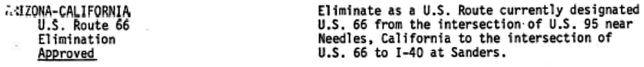
- 6 years (1979-1985): designation truncated to Sanders AZ.
- 1985: the US 66 designation was entirely decommissioned.
But now some questions arise, such as: where does that information come from? And what about the conventional wisdom that US 66 ended at 7th and Broadway in downtown Los Angeles? The answers are all part of a very long story. Where to begin? I think we need to start with the various organizations that were involved, and the types of decisions they were authorized (and not authorized) to make.
- AASHO (American Association of State Highway Officials): organized in 1914 to coordinate road standards between the states. After significant involvement from BPR (see below), in 1926 AASHO was authorized to make the final determination regarding which routes would be included in the US highway system, and the numbers by which they would be known. AASHO also produced a route log (with input from the state highway departments) which specified the control cities through which each US route would pass between its endpoints. However, AASHO was typically not involved with decisions about the specific routings of US highways, particularly through larger cities. These types of decisions were better left with local officials, so AASHO usually delegated this authority to the various state highway departments. (AASHO became AASHTO in 1973.)
- BPR (Bureau of Public Roads): this was a Federal agency which (among other functions) oversaw cooperative road construction carried out by both the U.S. government and the state highway departments. In 1924 AASHO recommended that BPR work with the state highway departments to determine which highways should be included in a premier national network that they envisioned. In response, BPR commissioned the Joint Board on Interstate Highways. In 1925 this Board passed along their recommendations to AASHO, and also granted that organization the authority to flesh out the details on the routes that would be included in the US highway system. (BPR's functionality has since been transferred to the Federal Highway Administration).
- CHC (California Highway Commission): beginning in 1911, this entity was tasked with determining the best routes for a continuous and connected state highway system. This is the organization that BPR and AASHO worked with to determine which routes in California were the best candidates for inclusion in the US highway system. Normally AASHO also would have deferred to the CHC's authority in matters involving specific intra-city routings in California. However, until 1933 CHC's focus was limited to intercity routes, i.e. the more rural segments of highways that ran between cities. So until then, CHC delegated the authority to determine intra-city routings to the municipal governments of the cities through which the highways passed. Then, in 1933, CHC was given the additional authority to maintain and signpost intra-city routes as well. (CHC can be thought of as a predecessor to today's CalTrans.)
- Municipal governments: until 1933, officials in cites like Los Angeles and Santa Monica were granted the authority to determine the specific routing of state highways that CHC had defined as passing through their city limits. Then in 1933 this became the responsibility of CHC.
- ACSC (Automobile Club of Southern California): while municipal governments had the authority to determine highway routings inside their boundaries, many cities in Southern California authorized the ACSC to take responsibility for posting the highway markers and other directional signage along those routes. Then in 1933 this too became the responsibility of CHC.
Now, with that background in place, we will move on to a history of the decisions and actions taken by these agencies that were relevant to US 66 in Southern California. (Note: admittedly this page is quite lengthy, but despite that, the following is really only a summary of the key points. There are many additional details, and if you are interested in digging deeper then I recommend this extensively-researched Gribblenation blog post.)
- 1912: The National Old Trails Road Association (NOTR) was established to promote a transcontinental auto route. The western terminus of the route was to be at Los Angeles.
- 1914: ACSC completed directional markings along the westernmost segment of the NOTR, which terminated on Broadway at 7th Street in downtown Los Angeles.
- 1925: BPR and the state highway departments had been working towards the goal of replacing the loosely-organized National Auto Trails system (of which NOTR was a part) with a network that was more standardized, reliable, and objective. At this time, after providing much in the way of guidance and preliminary suggestions, the Joint Board passed the baton to AASHO for finalization and implementation. They had in mind the number "60" for the Chicago-L.A. highway, indicating that they considered it to be among the major cross-country routes, therefore meriting one of the US x0 designations:

from Oct. 1925 Joint Board report
- 1926, July: Since most other US x0 routes were proposed to run essentially due east-west across the country, some states objected to using one of those designations (US 60) for the more diagonal Chicago-L.A. route (particularly Kentucky, which occupied a position on the nationwide "grid" where an east-west US 60 should have run). In response to this controversy, AASHO worked out a compromise to which all states agreed: the US 60 designation would be applied to a route along its expected location in the grid, while the Chicago-L.A. route would be changed to US 66.
|
1926, BPR and AASHO
|
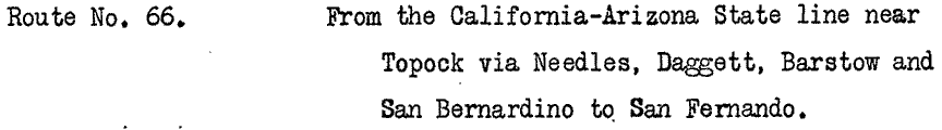
- 1927, February: One of AASHO's next steps was to produce and publish a log that described all of the routes that were included in the brand-new US highway system. In order to accomplish that, they sent a draft listing for each route to the state highway departments for review, correction, and approval. Below is an excerpt from the letter AASHO sent to CHC, showing the proposed description of US 66:
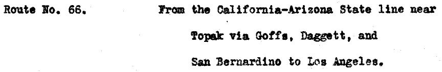
from AASHO to CHC
|
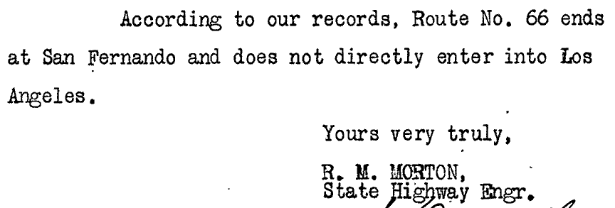
Mar. 1927, from CHC to AASHO
|
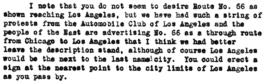
At this point we should pause and reflect on that statement. As far as I know, all material prior to this time consistently affirmed that the Chicago-L.A. route would end in, well... Los Angeles, obviously. Yet the above letter from CHC indicated their opinion that the route did not end in L.A. but rather in San Fernando, and furthermore that the route did not serve L.A. at all. Quite remarkable. It seems clear (and we will see more of this below) that CHC wanted US 66 to go to San Fernando, because that would create a US route that bypassed central L.A. by going directly between the San Fernando Valley and San Bernardino (via the San Gabriel Valley). However, CHC did not have the authority to change US 66's terminus from Los Angeles to San Fernando. I believe that disconnect is a key to understanding the confusion that ensued about where, exactly, US 66 was supposed to go... and why it was not signposted in Los Angeles for the first four years. As for AASHO, they did not seem to immediately grasp the import of CHC's statement. I am not sure they even paid much attention to the actual location of San Fernando (which is 22 miles north of downtown Los Angeles). As we will see below, AASHO may have erroneously assumed San Fernando was just a town somewhere between San Bernardino and Los Angeles, and just figured that CHC had their own reasons why they thought it was important to add San Fernando to the route description.
|
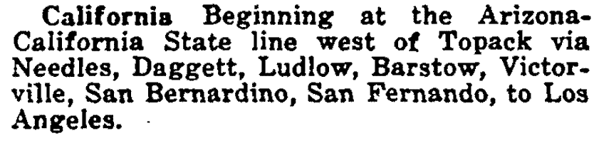
from Apr. 1927 American Highways (an AASHO publication)
|
|
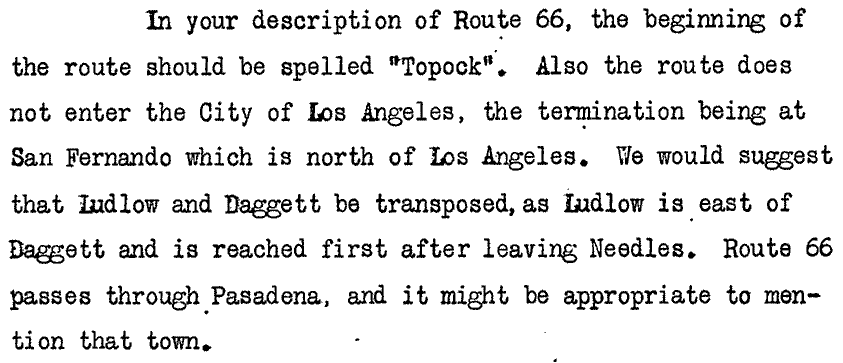
Apr. 1927, from CHC to AASHO
|
|
Apr. 1927, from CHC to AASHO
|
- 1927, April (cont'd): In response to those statements from CHC, it would have been within AASHO's authority to say something along the lines of, "AASHO has already determined that US 66 ends in Los Angeles. CHC does not have the authority to claim that it ends in San Fernando." But the actual response that AASHO sent to CHC was quite a bit more restrained than that, and they still did not attempt to understand the reason why CHC believed that US 66 needed to go to San Fernando:
Apr. 1927, from AASHO to CHC
|
from May 1927 AASHO route log
|
But there was still a disconnect: AASHO continued to show Los Angeles as a control point, whereas CHC was still insisting that US 66 did not serve Los Angeles.
|
from Jan. 1928, California Highways and Public Works
|
- 1928, May: already by this time Santa Monica boosters were advocating to have the US 66 designation extended westward from Los Angeles, such that it would terminate in their city on the Pacific shoreline. Newspaper articles from the following year indicate that the Los Angeles city council intended to cooperate with Santa Monica to have US 66 extended as desired.
|
from 1929 AASHO route log (same description in 1935 issue)
|
|
1930, CHC
|
|
...but in a sense all of that was academic, because up to this point no US routes had been signposted within the Los Angeles city limits. And that is why US 66 never ended at 7th and Broadway in downtown L.A. Sure, there are many publications that assumed 7th/Broadway was the terminus (various tour books and travel guides, for example, as well as some commercial maps). In the absence of any official proclamations or data, these publishers had no choice but to make their own conclusions, and many of them just assumed US 66 would precisely overlap the NOTR. But prior to 1931, no organization with the authority to determine US 66's western terminus ever corroborated that idea: not AASHO, not CHC, and not the City of Los Angeles. Here is a photo that was taken from 7th, looking north on Broadway:
|
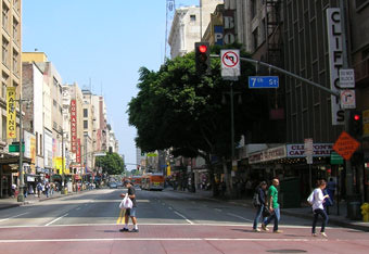
Resch, Sep. 2007
|
|
Straight ahead was the west beginning of the National Old Trails Road, but never officially US 66. Heading the opposite direction on Broadway (south), one can view the sign shown here:
|
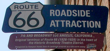
Resch, Sep. 2007
|
Despite what that sign says, it was actually 1935 (not 1939) when the terminus of US 66 was extended west of L.A. (as we will see below). But more to the point, that intersection was actually never an official terminus of US 66 at all. So then, where did US 66 end prior to 1931? I think the best answer is: it had no endpoint, because its terminus was not defined. AASHO specified that US 66 ended in L.A. but did not define exactly where. CHC and/or the City of Los Angeles had the authority to define the exact endpoint, but they did not do that until 1931. Prior to that, US 66 signage just petered out somewhere east of L.A. Drivers wanting to continue west to downtown L.A. may well have followed NOTR signs to get there, but the route they were following had not been defined as US 66 by any organization with the authority to do so. However, things were about to get even more interesting:
- 1930, February: the Los Angeles city council minutes reveal that the City was only then getting around to determining how US 101, 99, and 66 traffic should be directed through the city. And at this meeting they still did not decide on a routing for US 99 west of US 101, and they avoided making a decision on US 66 altogether, for the explicitly-stated reason that there was "uncertainty as to the location of this Federal Highway". It is unknown exactly when ACSC carried out the Council's directive to signpost US 101 (and part of US 99) through Los Angeles, but we can reasonably assume it was later in that same year (1930).
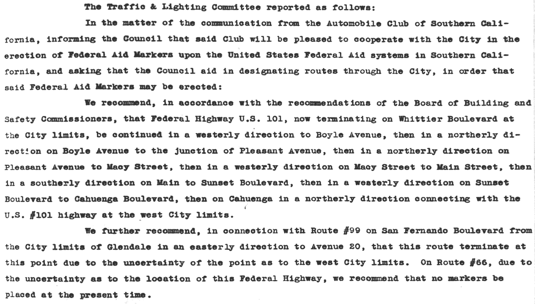
Feb. 1930, L.A. city council minutes
- 1930, December: the L.A. City Council voted to make good on their 1929 pledge to work with the City of Santa Monica by authorizing ACSC to signpost US 66 through the L.A. city limits and beyond, to a terminus in Santa Monica. Local newspapers reported that US 66 signposting was completed in January 1931, and that the terminus of this signage was on Santa Monica Boulevard at Ocean Avenue.
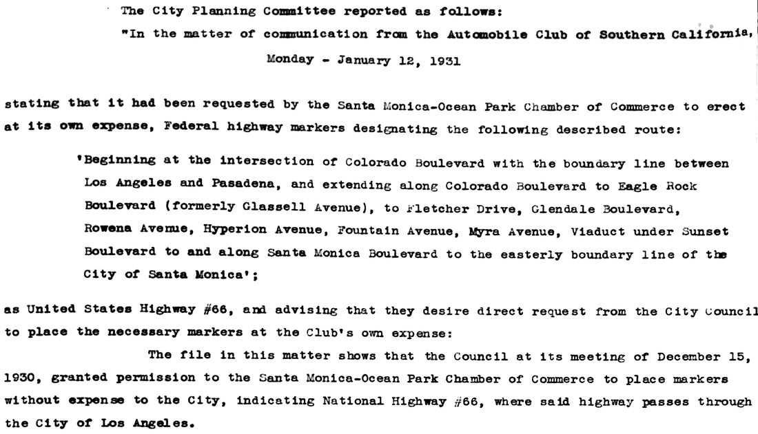
Jan. 1931, L.A. city council minutes
|
So that was the first signposted endpoint of US 66, but that terminus was never approved by any organization that had the authority to do so. This photo was taken looking west down Santa Monica Boulevard, where it ends at Ocean Avenue:
|

Elbert, Mar. 2005
|
Nearby is a Will Rogers/US 66 historical marker. Perhaps for both of those reasons, that intersection is often cited as the west terminus for historic US 66, but that was never an official endpoint, and even unofficially it lasted for only a few months. (Incidentally, the Santa Monica Pier was also never an endpoint of Route 66.)
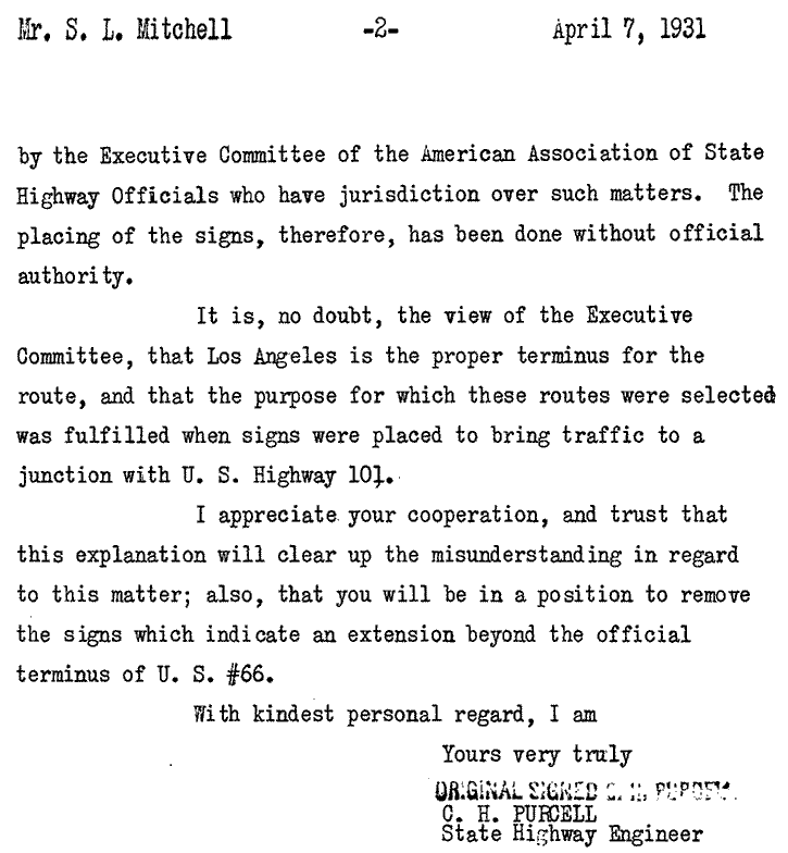
- 1931, March: CHC became aware of US 66 signage to Santa Monica, and responded by asking ACSC to remove all US 66 signs west of the Los Angeles city limits. CHC reported the incident to AASHO in April, and Santa Monica newspapers show that the US 66 signs had been removed by May 1931.
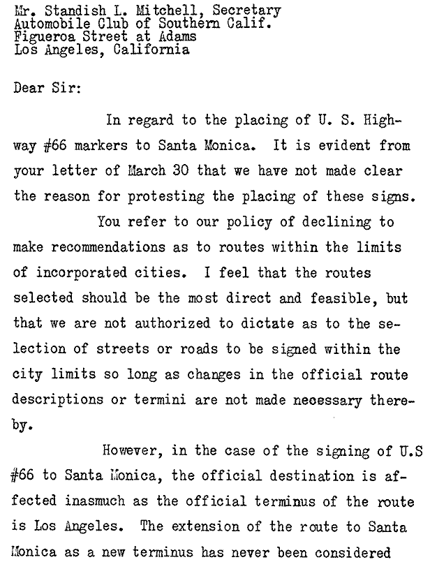
Apr. 1931, from CHC to ACSC (p.1)
|
Apr. 1931, from CHC to ACSC (p.2)
|
Sep. 1931, from CHC to AASHO
|
Nov. 1931, from CHC to AASHO
|
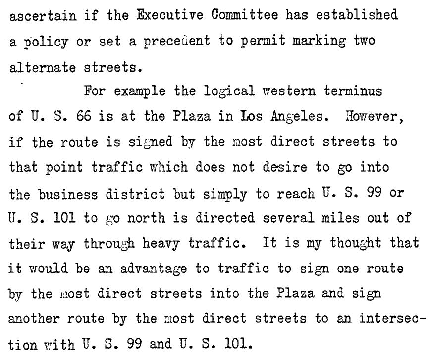
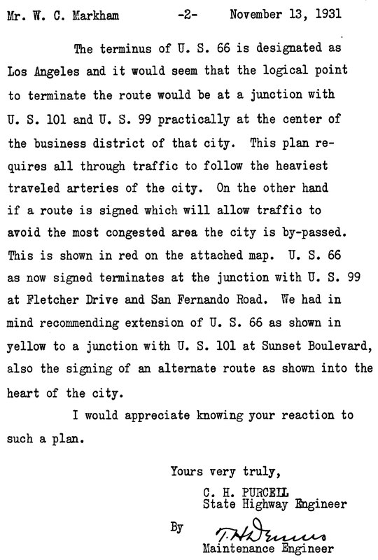
Note that the western terminus of US 66 as then-signed was explicitly stated to be on Fletcher Drive at its junction with US 99 (San Fernando Road), and that was also illustrated on the included map:

Nov. 1931, CHC to AASHO
|
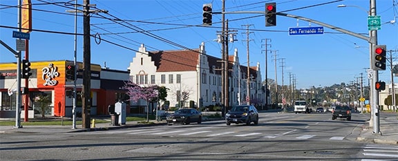
So Fletcher at San Fernando was the first west terminus of US 66 that was both authorized and signposted. Here is a modern photo looking southwest on Fletcher; US 66 ended here at San Fernando, at its junction with US 99. Today no signed highways pass through this intersection, and it is rather generic and non-descript, except for the 1930 Van de Kamps Holland Dutch Bakery building visible in the background:
|
Fearer, Mar. 2023
|
This 1936 photo was taken from roughly the same perspective; part of the Van de Kamps building is visible at upper left, as well as a Dutch windmill that sat on the southwest corner of the intersection. This was a few years after US 66 had been rerouted away from this intersection, but it still gives a good idea of how the intersection looked when US 66 ended here. At the time, CA hwy. 2 continued ahead on Fletcher (that designation has long since been shifted a block or so to the south, along the Glendale Freeway):
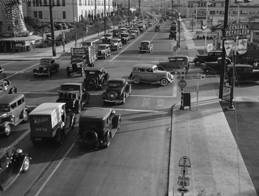
c. 1936 (attribution unknown)
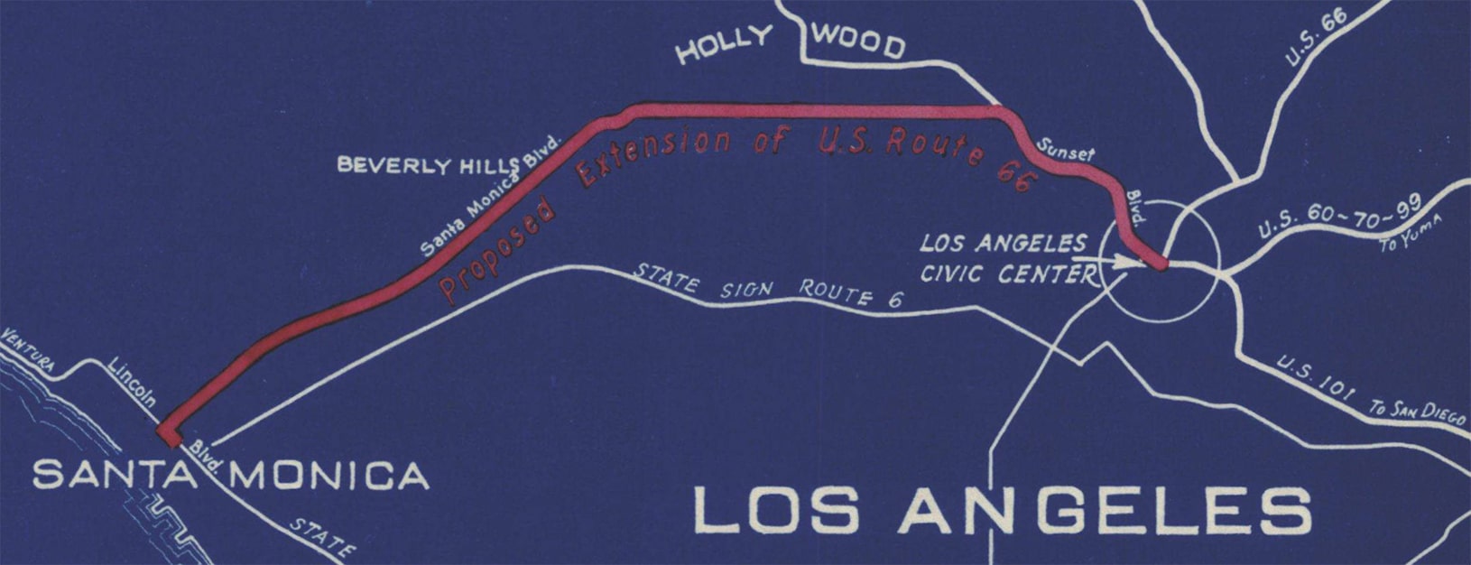
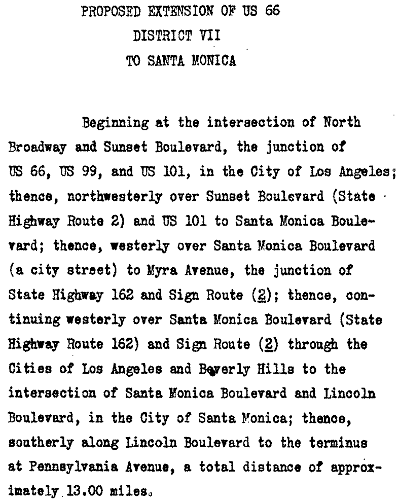
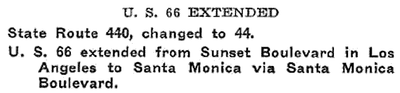
It is interesting to note that the northern fork of US 66 shown on the preceding map -- combined with an obvious extension along Santa Monica Blvd -- was the same route that had been briefly signposted as US 66 to Santa Monica earlier that same year. So it appears that when ACSC was instructed to remove US 66 signage west of L.A. city limits, they retracted signage all the way back to the junction with US 99 (San Fernando Rd). It is unknown why they would not have left US 66 signs up between there and US 101 (via Fletcher and Hyperion, the short segment shown in yellow). At any rate, the concern expressed by CHC could have been easily addressed by signposting the proposed southern fork as "Business US 66" and the northern route as "Bypass US 66". However, I think the concept of bannered routes had not yet been fully developed, because AASHO simply responded with a concern that two endpoints for US 66 could prove confusing for travelers. They instead suggested that CHC extend one of the US 66 forks to Santa Monica, and extend the other fork such that it junctioned the first fork somewhere between L.A. and Santa Monica. That way one of the forks could carry mainline 66 traffic and the other could be designated Alternate 66. But CHC expressed their opinion that would not solve their issue, and asked again if AASHO would approve their proposal as outlined above.
|
AASHO was somewhat vague and non-committal in their response, but it was clear they were opposed to a split terminus for US 66. Because of that, and because I have not seen evidence suggesting that CHC ever implemented their "dual-prong" solution, I suspect in about January 1932 US 66 was signposted along the southern fork only, and that the route terminated on Broadway at its junction with US 101 (Sunset Boulevard). That was certainly the case by 1935, as illustrated on this commercial map (and we will see additional evidence of this endpoint below):
|
c. 1935, Gousha
|
|
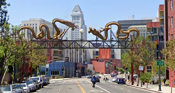
This image was looking south on Broadway; Cesar Chavez (nee Sunset Blvd) is the traffic signal in the background (and beyond that is the iconic L.A. City Hall building).
|
Google Maps Street View, Jun. 2022
|
|
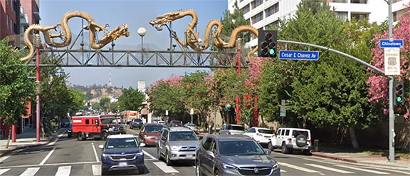
That was the second official west terminus of US 66, and it lasted a little longer than the first, about four years. This next image was looking the opposite direction (north on Broadway); US 66 began straight ahead:
Google Maps Street View, Sep. 2021
At far right a Route 66 marker is visible, it is shown close-up here:
|
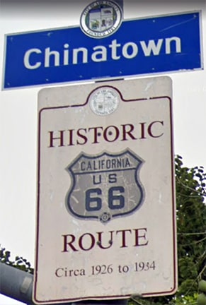
Google Maps Street View, Dec. 2021
|
|
1934, CHC to AASHO
|
1935, CHC to AASHO
1935, CHC to AASHO
|
|
|
|
|

c. 1956, Gousha
|
|
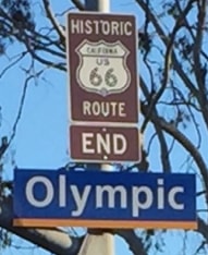
Route 66 traffic was directed southeast on Lincoln Boulevard to Olympic, where the designation ended at US 101A. These photos were taken from that perspective; "End" and "Begin" signage was added to this intersection in 2016:
|
Elbert, Mar. 2005
|
Maximous, Nov. 2016
|
As an aside, just past Olympic today is the interchange with I-10. Known locally as the Santa Monica Freeway, I-10 runs from here to Jacksonville FL: a distance of over 2400 miles.
This photo was taken looking southwest on Olympic (CA hwy. 26); US 66 began to the right on Lincoln: |
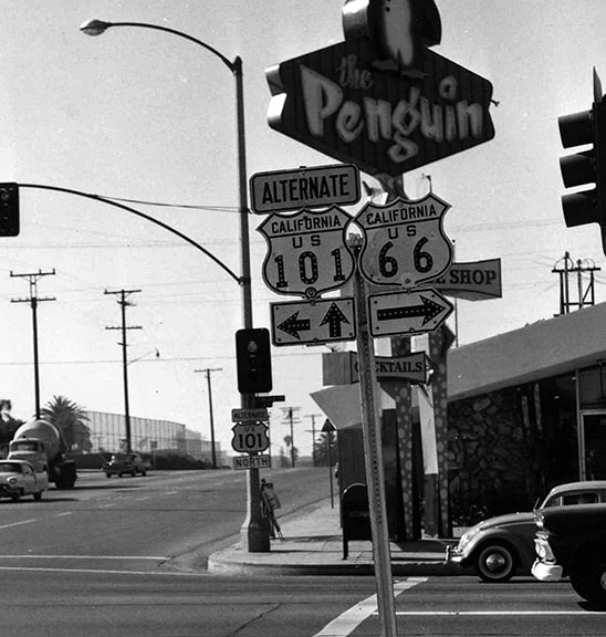
c. 1964, Caltrans
|

|
(Incidentally, "The Penguin" shown in that photo no longer exists, but that building still stands, and as of 2018 its outdoor signage still featured a penguin.)
That was the west terminus of US 66 for nearly 30 years, but later that same year (1964) CalTrans received permission to decommission US 66 to the Arizona state line. However, they did not immediately remove all US 66 signage; rather they only removed signs between Santa Monica and Pasadena: |
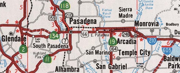
c. 1970, Caltrans
|
|
This interactive image is looking east on Colorado Boulevard in Pasadena. For a time, this was the east end of CA 134, while CA 11 began to the right on Arroyo Parkway, and the signposted segment of US 66 began straight ahead:
|
|
|
But ultimately Caltrans didn't want US 66 at all, and within ten years they had removed the designation from their state completely, such that its west end was at the Arizona state line.
It was not long before Arizona started to remove US 66 signage along I-40 in their state too. In fact, there is evidence that by the mid-1970s the only place in Arizona where US 66 was still signposted was the stretch that diverged from the I-40 corridor (between Seligman and Kingman). Someone wrote with their recollection that there was an "End US 66" assembly posted in Kingman at I-40's exit 53 (where AZ 66 ends today)... |

Teresco, Oct. 2003
|
...however, Arizona did not make that official with AASHTO until 1979, when they obtained permission to truncate the route all the way to Sanders (which is not far from the New Mexico line):
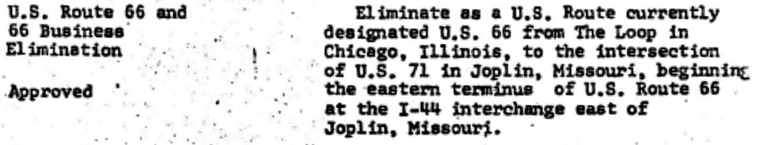
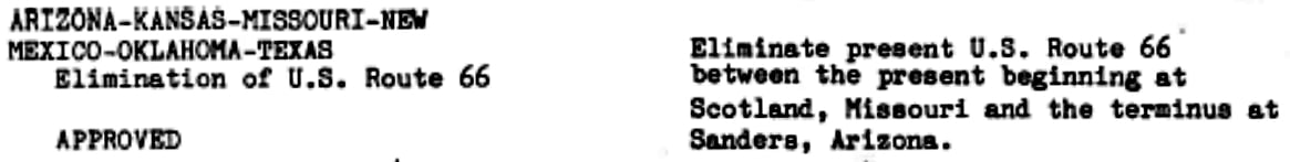
That was the final western terminus of US 66, until the route was decommissioned in its entirety in 1985. Meanwhile, the east end of US 66 was becoming obsolete as well: in 1974 Illinois and Missouri obtained AASHTO's permission to truncate the route between Chicago and Scotland (outside of Joplin)...
...although apparently signage between those points was not removed until 1977. East of Joplin, US 66 originally went up through Webb City and Carthage, then followed what is now MO 96 to Springfield. At the time, US 166 followed I-44 out of Joplin (roughly), and then today's MO 174 from Mt. Vernon to Springfield.
|
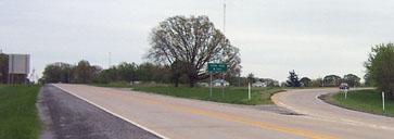
But when US 66's replacement route was complete (I-44 to St. Louis and I-55 to Chicago), it was re-routed such that it went straight east from Joplin (along old US 166) and ended at I-44's interchange 15 (where MO hwy. 66 ends today). This photo shows that spot:
|
Maness
|
|
That is in Scotland, about eight miles east of downtown Joplin. Business I-44 and MO 66 traffic are directed onto the ramp at right, which leads to eastbound I-44. Ahead was US 166, but now it serves as an off-ramp from westbound I-44. That is where US 66 ended from 1979 to its decommissioning in 1985.
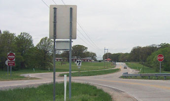
If one were to continue ahead about a quarter-mile and then turn around, this photo shows that perspective: |
Maness
|
|
That is looking the opposite direction (west). Westbound I-44 exits and comes in from the lower left, and aligns due west ahead on what becomes 7th Street Joplin in a few miles. At lower right is old US 166, which is now just a frontage road for I-44 (or "outer road", as they are referred to in Missouri). That was the east beginning of US 66 for its final six years.
This photo shows a work crew replacing US 66 shields with Missouri 66 signs: |
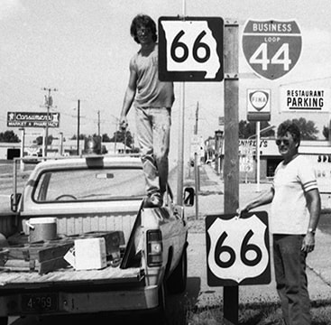
July 1985, Joplin
|
That was only about one month after AASHTO's June 1985 meeting, which is when they approved the elimination of the US 66 designation, from Missouri all the way to Arizona:
Research and/or photo credits: Chris Elbert; Tom Fearer; Scott Maness; Andrew Maximous; Dan Resch; Mike Roberson; Dale Sanderson; Joe Sonderman; Michael Summa; Jim Teresco
Page originally created 2000;
last updated Dec. 17, 2023.
last updated Dec. 17, 2023.
