US Ends .com
  • Home
  • Store
    • US highway book
    • US highway map
    • Florida US highway map
  • Endpoints
    • US 1 - US 9 >
      • 1 >
        • 201
        • 301
        • 401 [i]
        • 401 [ii]
        • 401
        • 501
        • 601
        • 701
      • 2w >
        • 102
      • 2e >
        • 202
        • 302
      • 3
      • 4 >
        • 104
      • 5
      • 6 >
        • 106
        • 206
      • 7
      • 8
      • 9 >
        • 109*
        • 209
        • 309
    • US 10 - US 19 >
      • 10 >
        • 110
        • 210
        • 310
        • 410
      • 11 >
        • 111
        • 211
        • 311
        • 411 [i]
        • 411 [ii]
        • 411
        • 511*
        • 611
        • 711*
      • 12 >
        • 112
        • 212
        • 312
      • 13 >
        • 113
        • 213
      • 14
      • 15
      • 16 >
        • 116
        • 216
      • 17 >
        • 17-1
        • 117 [i]
        • 117
        • 217
      • 18 >
        • 118
        • 218
      • 19 >
        • 119
        • 219
        • 319
    • US 20 - US 29 >
      • 20e >
        • 120
        • 220
        • 320
        • 420
      • 20w
      • 21 >
        • 121 [i]
        • 121
        • 221
        • 321
        • 421
        • 521
      • 22 >
        • 122 [i]
        • 122 [ii]
        • 222
        • 322
        • 422e
        • 422w
        • 522
        • 622*
      • 23 >
        • 123 [i]
        • 123
        • 223
      • 24 >
        • 124
        • 224
      • 25
      • 26 >
        • 126
      • 27 >
        • 127
        • 227
      • 28
      • 29 >
        • 129
    • US 30 - US 39 >
      • 30 >
        • 130
        • 230
        • 330
        • 430
        • 530
        • 630*
        • 730
        • 830
      • 31 >
        • 131
        • 231
        • 331 [i]
        • 331
        • 431
      • 32
      • 33
      • 34
      • 35
      • 36 >
        • 136
      • 38 >
        • 138
    • US 40 - US 49 >
      • 40 >
        • 140
        • 240
        • 340
      • 41 >
        • 141
        • 241 [i]
        • 241 [ii]
        • 341
        • 441 >
          • 441n
          • 441s
        • 541
        • 641
      • 42
      • 43
      • 44
      • 45
      • 46
      • 48 [i]
      • 48 [ii]
      • 48
      • 49
    • US 50 - US 59 >
      • 50 >
        • 150
        • 250
        • 350
        • 450
        • 550
        • 650
      • 51 - 55 >
        • 51 >
          • 151
        • 52 >
          • 152
        • 53
        • 54 >
          • 154
        • 55
      • 56 >
        • 156
      • 57
      • 58 >
        • 158
        • 258
      • 59 >
        • 159
        • 259
    • US 60 - US 69 >
      • 60 >
        • 160
        • 260
        • 360
        • 460
      • 61 - 65 >
        • 61 >
          • 161
        • 62
        • 63 >
          • 163 [i]
        • 64 >
          • 164 [i]
          • 164 [ii]
          • 264
        • 65 >
          • 165
      • 66 >
        • 166
        • 266
        • 366 [i]
        • 366 [ii]
        • 466 [i]*
        • 466 [ii]
        • 566
        • 666
      • 67 >
        • 167
      • 68 >
        • 168
      • 69 >
        • 169
    • US 70 - US 79 >
      • 70 >
        • 170
        • 270 [i]*
        • 270
        • 370
        • 470
      • 71 >
        • 171
        • 271
        • 371 [i]
        • 371 [ii]
        • 371
      • 72 - 76 >
        • 72
        • 73
        • 74
        • 75 >
          • 175
          • 275
        • 76 >
          • 176
          • 276
      • 77 >
        • 177
        • 277
        • 377
      • 78 >
        • 178
        • 278
        • 378
      • 79
    • US 80 - US 89 >
      • 80 - 84 >
        • 80 >
          • 180 [i]
          • 180
          • 280
          • 380
        • 81 >
          • 181
          • 281
        • 82
        • 83 >
          • 183
          • 283
          • 383
        • 84
      • 85 - 89 >
        • 85 >
          • 185
          • 285 [i]
          • 285
          • 385 [i]
          • 385
          • 485
        • 87 >
          • 187
          • 287n
          • 287s
        • 89n
        • 89s >
          • 189 [i]
          • 189
    • US 90 - US 99 >
      • 90 - 94 >
        • 90 >
          • 190
          • 290
        • 91 >
          • 191 >
            • 191n
            • 191s
          • 491
        • 92 >
          • 192
        • 93
        • 94
      • 95 -98 >
        • 95 >
          • 195
          • 295
          • 395
        • 96 [i]
        • 96
        • 97 >
          • 197
        • 98
      • 99 >
        • 199
        • 299
        • 399
    • Anomalies >
      • 101
      • 163
      • 400
      • 412
      • 425
  • Places
    • A-L >
      • A >
        • Aberdeen
        • Albuquerque
        • Amarillo
        • Apalachicola
        • Astoria
        • Atlantic
      • B >
        • Baltimore
        • Baton Rouge
        • Bay Area
        • Bishop
        • Boone
        • Brady
        • Bristol
        • Brownsville
        • Brunswick
      • C >
        • Charleston
        • Chattanooga
        • Chicago
        • Cincinnati
        • Cleveland
        • Cody
        • Corpus
        • Cortez
        • Council Bluffs
        • Covington
        • Crescent
        • Cumberland Gap
      • D-E >
        • Dallas
        • Des Moines
        • Detroit
        • Dothan
        • Douglas
        • El Paso
        • Erie
        • Eugene
      • F >
        • Farmington
        • Flagstaff
        • Florence
        • Fox Valley
        • Franklin
      • G >
        • Gallup
        • Georgetown
        • Grand Junction
        • Grand Portage
        • Grayling
        • Great Falls
        • Greeley
      • H-I >
        • Hardeeville
        • Harrisburg
        • Holbrook
        • Idaho Falls
        • Int'l Falls
      • J-K >
        • Jacksonville
        • Joplin
        • Junction
        • Kansas City
        • Keokuk
        • Key West
        • Kingman
      • L >
        • Laredo
        • Lewiston
        • Long Beach
        • Los Angeles
        • Louisville
        • Lubbock
    • M-R >
      • M >
        • Mackinaw
        • Madison
        • Maryhill
        • Maysville
        • Miami
        • Midway
        • Miles City
        • Milford
        • Milwaukee
        • Minneapolis
        • Mobile 31
        • Mobile 31-43-45
        • Montgomery
        • Monticello
        • Mount Vernon
      • N-O >
        • Nags Head
        • Naples
        • Natchez
        • New Castle
        • New Orleans
        • Niagara
        • Norlina
        • Ocean City
        • Oklahoma City
      • P >
        • Pee Dee
        • Pembina
        • Pensacola
        • Petersburg
        • Philadelphia
        • Piegan
        • Pineville
        • Port Arthur
        • Portsmouth
      • Q-R >
        • Quad Cities
        • Rapid City
        • Raton
        • Reading
        • Richmond
        • Rockingham
        • Rouses Point
    • S-Z >
      • S >
        • San Antonio
        • San Antonio NM
        • San Diego
        • Santa Fe
        • Savannah
        • Sioux
        • Springer
        • Springfield
        • St. Ignace
        • St. John
        • St. Paul
        • St. Pete
      • T-U-V >
        • Tallahassee
        • Tampa
        • Toledo
        • Trinidad
        • Tuba City
        • Ucolo
        • VA Beach
      • W >
        • Walterboro
        • Waverly
        • West Memphis
        • Wilmington
        • Wilson
        • Wrightsville
      • Y >
        • Yellowstone E
        • Yellowstone N
        • Yellowstone NE
        • Yellowstone S
        • Yellowstone W
  • Highways
    • Map of all endpoints
    • Sources
    • History
    • 1926 almost-routes
    • Intra-state routes
    • Numbering
    • Colors
    • Gaps
    • Blog
  • Bonus
    • Colorado >
      • Lowest point
      • Antipodes
      • Toponymy >
        • Roots
      • Colloquialisms
      • Populations
      • Denvers
    • Washington Meridian
    • Watersheds >
      • Headwaters Hill
      • Three Waters Mtn.
      • Parting of the Waters
    • Geo-centers >
      • 48 states
      • 50 states
      • North America
    • State corners >
      • AZ-CO-NM-UT
      • CO-UT-WY
      • CO-NE-WY
      • CO northeast
      • CO-KS-NE
      • CO-KS-OK
      • CO-NM-OK
      • NM-OK-TX
      • NM southeast
      • TX northwest
  • Connect
    • Author/history
    • Rationale
    • Contact
    • Contributors
    • Submissions

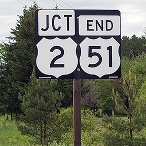
End of US highway 51

View a map showing this route.
Get your very own map showing all current and historic US routes!
Picture
Summa
Picture
Summa
Mileage: in 1989 AASHTO listed a figure of 1332 miles for US 51... however, that included the mileage of US 51's associated business routes.  According to the state subtotals on AASHTO's 1989 spreadsheet, mainline US 51's actual end-to-end total at the time was 1286 miles.  That is reasonably close to our own 2020 measurement, which yielded 1269.8 miles.  ​Want historic mileages?  Our handy reference book includes the mileages that were published in all 13 of AASHO/AASHTO's historic route logs (spanning the years 1927 to 1989).
1926-1951
  • North: Hurley, WI
  • South: New Orleans, LA
1951-present
  • North: Hurley, WI
  • South: Laplace, LA
Get your copy of this epic book that commemorates the first century of the US route system!

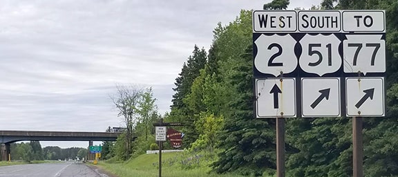
The north end of US 51 has always been in Hurley, although the endpoint has changed.  Today US 2 bypasses Hurley to the north, but until the mid-1930s it went right through the center of town, via Division, 5th, and Silver.  US 51 came in from the south, but instead of swinging over to 2nd Avenue (as it does today), traffic remained on 3rd Avenue, making a slight jog at Iron Street before continuing north and ending at Silver Street:
Picture
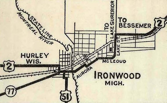
c. 1927, Michigan DoT (linked to source)

This image was looking east on Silver (which carries WI 77 today, but was historically US 2):
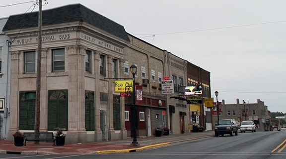
Picture
Wicks, Sep. 2012
At the pictured intersection, to the right on 3rd was the original north beginning of US 51.

​Today the junction with US 51 is one block ahead, at 2nd.  This photo was taken from westbound Silver at that intersection:
Picture
Morrison, July 2013

It appears US 51 began using 2nd in about 1935, and it probably never ended on 2nd at Silver.  That was about when US 2 was rerouted to stay on Cloverland Drive in Ironwood MI (the city directly across the Montreal River), which meant the new highway aligned to the north of downtown Hurley.  As a result, US 51 had to be extended north in order to junction the "new" US 2.  3rd was not a through road, so US 51 traffic was shifted over to 2nd, where it has remained ever since.  Here is how the "End" assembly looked historically...
Picture
Osbaldeston, June 2001
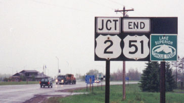
...but that was later replaced.  For awhile there was also a reference to the Lake Superior Circle Route...
Picture
Morrison, July 2013
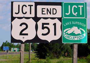
...and in case you missed that one, there was another just ahead...
Picture
Morrison, July 2013

...but those have since been replaced as well.  As of 2020 there was no reference to the Circle Tour, and apparently it was decided that just one "End" assembly was sufficient:
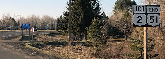
Picture
Johnson, Apr. 2020
Picture
June 2020, Laessig
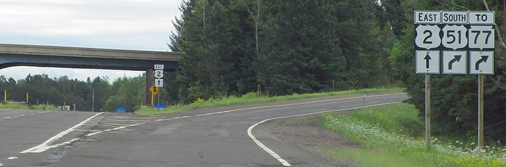
Just ahead was the actual terminus of the designation at the junction with US 2.  ​
In this photo, if one turned east (right) on US 2, they crossed the river into Ironwood MI.  If a driver went west (by going straight across an overpass, then curving left to merge with US 2), they were heading toward Ashland and the twin ports of Superior WI and Duluth MN...
Picture
Johnson, Apr. 2020
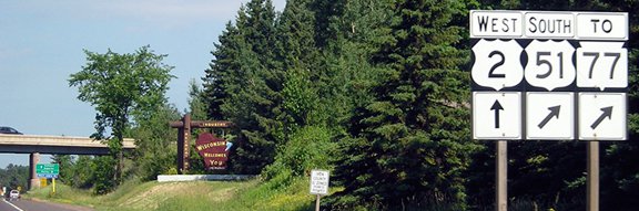
...although in 2021 the configuration of this intersection changed.  The overpass has been removed, and the two highways intersect at a roundabout (although signage has not changed much).  This photo was taken from eastbound US 2:
Picture
Dienhart, Aug. 2020
The north beginning of US 51 was to the right.  The overpass in the background (gone now) is also visible in the photos below, which were taken from the opposite direction (west on US 2):
Picture
Morrison, July 2013 (unchanged since at least 2003)
Picture
June 2020, Laessig
There we had just crossed a bridge over the river (which divides Ironwood and Hurley, as well as the states of Michigan and Wisconsin in this area; the Wisconsin welcome sign is shown in the background, and it still exists at the new roundabout).  ​
Southbound US 51 traffic passed under the bridge, exited right, and looped back over the bridge from right-to-left.  Drivers making that movement soon observed the first southbound marker:
Picture
Morrison, July 2013
Picture
Dienhart, Aug. 2020

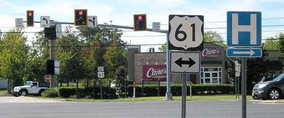
At its south end, US 51 was formerly signed further than it is now: from Laplace LA it was overlapped eastward with US 61 (and US 65) all the way down to New Orleans.  Those three routes ended at the same place where a fourth route (US 11) ended: the intersection of Broad Street and Canal Street (more info on the New Orleans page).
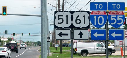
In 1951, US 51 was truncated to its junction with US 61 in Laplace (west of New Orleans).  Until fairly recently, US 51 traffic was routed along what is now Main Street, or "Old 51" according to some street signs in the area.  This photo was looking south on Main at its junction with US 61:
Picture
Karner, Jun. 2013
​That is where US 51 used to end (and now the east beginning of LA 44 is straight ahead).  Below we are looking west on Airline Highway (or north on US 61):
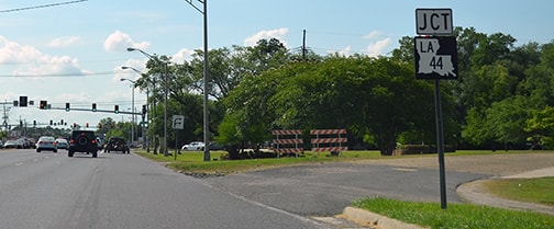
Picture
Nitzman, May 2015
Visible to the right is what was once a high-speed slip ramp leading to northbound US 51.  Today that only provides access to a business, and then it is barricaded.  But the road itself continues, and on the far side of the barricade it is now known as "Circle Drive".  It still connects to Main, but it is no longer a one-way ramp; it functions as a normal neighborhood street, providing access to a few private residences.  Continuing ahead on Airline, we come to the junction with Main itself:
Picture
Karner, Jun. 2013
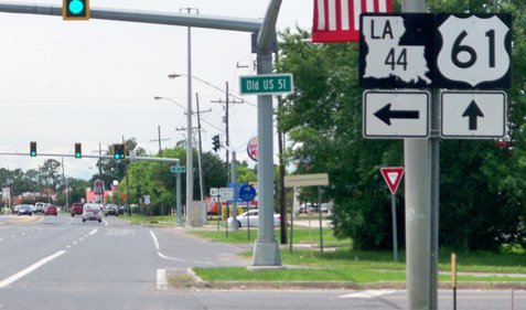
​The south beginning of US 51 was to the right.  But in 1986, US 51 was rerouted along a newer alignment which bypasses the "Old 51" neighborhood.  The newer highway begins at the next traffic signal; here is a close-up view of the signage there:
Picture
Karner, Jun. 2013

That's more of a standard 4-way intersection; one cannot make that right-hand turn at the same rate of speed as they could onto the old US 51.  The cars visible in the foreground of that photo are at the south end of US 51; they were viewing the perspective shown here:
Picture
Karner, Jun. 2013
In the background was a green sign pointing left to New Orleans.  By 2016 that had been replaced by a "JCT US 61" assembly...
Picture
Morrison, Oct. 2016
...but that location is way too late for a junction sign.  A more appropriate sign in that location would be an "END US 51" assembly.

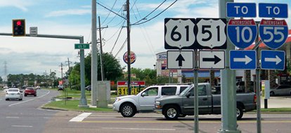
Now, heading back the opposite direction (east on Airline), here is the signage at the beginning of modern US 51:
Picture
Karner, Jun. 2013
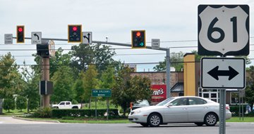
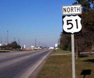
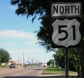
Going straight on US 61, the next intersection is the historic beginning of US 51.  But if a driver takes that left turn, they will soon see the first northbound confirming marker on current US 51:
Picture
Nitzman, 1999
Picture
Morrison, Oct. 2016

Research and/or photo credits: Paul Dienhart; Peter Johnson; Martin Karner; Joel Laessig; Jeff Morrison; Robert Mortell; Steven Nelson; Alex Nitzman; Greg Osbaldeston; Mike Roberson; Dale Sanderson; Michael Summa; Bruce Wicks
Page originally created 1999;
last updated Aug. 21, 2023.
Copyright © 1998-2025
Picture