Current and historic US highway endpoints in Chattanooga, TN
|
1928-present
|
 |
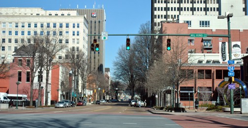
Several US routes end in Chattanooga (or have ended there historically). Many of these endpoints are/were common to more than one highway, so this page covers all Chattanooga endpoints. Rather than organizing these locations numerically or chronologically, in this case they are organized geographically. We will start at the current signed end of US 127 north of downtown, and work our way down to the south; then we will turn around and generally head back north to the point of beginning.
|
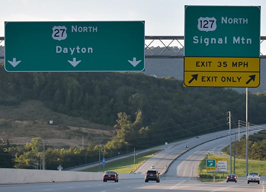
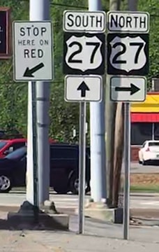
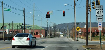
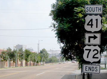
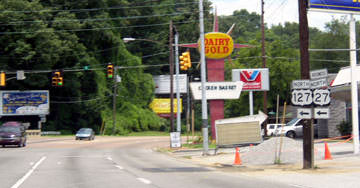
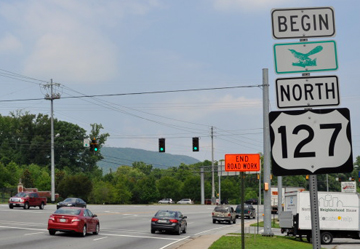
US 127 was extended to Chattanooga in 1958. It is routed along Signal Mountain Boulevard, and (according to signage anyway) begins at the US 27 freeway:

Nitzman, June 2005
|
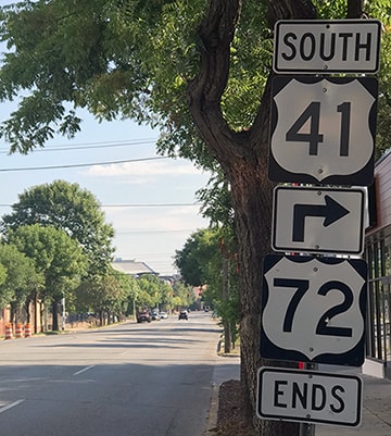
Nasiatka / Nitzman, Jul. 2022
|
|
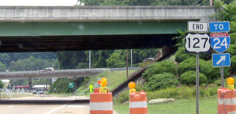
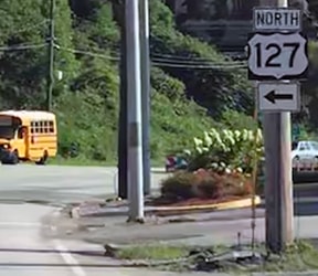
Those were from northbound US 27; note how US 127 is described as heading "North" only. According to TNDoT route descriptions, it actually continues south from there as well, ending downtown. But apparently TNDoT wants that to be kept secret from the driving public: heading south on US 127, there is no signage beyond the junction with the US 27 freeway. In fact, at one time there was an "End" assembly at the interchange with US 27:
Patriarca, summer 2003
|
Nasiatka / Nitzman, Jul. 2022
|
|
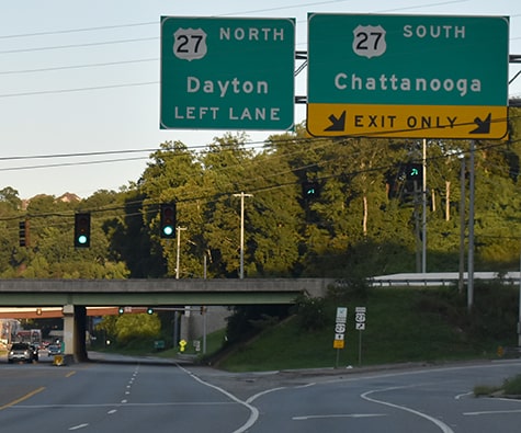
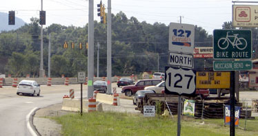
The overpass is the "new" US 27. That "End" sign (gone by 2007) was perplexing, because TNDoT documents indicate that US 127 officially continues ahead on Signal Mountain to Dayton Boulevard (which is the old US 27), and then south. But even heading south on Dayton, signage does not indicate that US 127 continues south of Signal Mountain:
|
Oct. 2011, Google Maps Street View
|
Sanderson, Aug. 2018
|
|
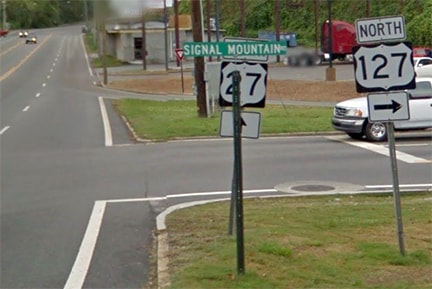
(Incidentally, the intention there is "TO South US 27", because there is a ramp to the US 27 freeway about a half-mile ahead.) It was 1928 when US 27 was first extended to Chattanooga. At the time, US 41 followed a different route than it does today east from Jasper, coming to this point via what is now US 127 (Signal Mountain). US 27 came south on Dayton, so it could have ended there at its junction with US 41. But it is more likely that the two routes overlapped straight ahead into downtown Chattanooga. Today, that is what US 127 does, according to TNDoT: officially it continues straight ahead on Dayton, which becomes Cherokee Boulevard. At Market Street, US 127 turns south to cross the Tennessee River... but there is no signage to indicate these movements. At 9th Street, or M.L. King Boulevard, we reach the official south end of US 127:
|
Sanderson, Aug. 2018
|
|
Formerly that junction made a somewhat reasonable endpoint, as US 11-64 was routed along MLK. But those routes no longer come through here. And at any rate, there is absolutely no highway signage at any approach to this intersection. Making this junction even more interesting is the fact that the west beginning of US 76 is straight ahead on Market (officially, that is... although again, there is no signage in this area for that route, either. And as a matter of fact, what signage does exist for US 76 is even more misleading than the signage for US 127, as we will see below).
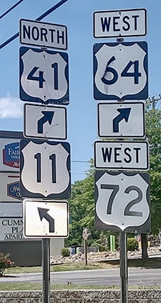
Two blocks ahead (at 11th Street), we reach the intersection which, at various times, has served as the terminus of US 27, US 64, US 72, and US 76: |
Sanderson, Aug. 2018
|
|
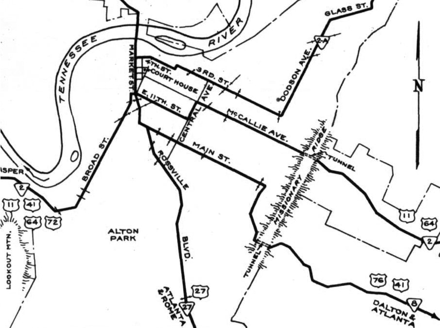
From about 1928-1934, that was the south end of US 27. From 1932-1958, US 76 began to the left on 11th. And from 1932-1933, US 64 began to the right on 11th. This map captured the brief moment in time where all three of those routes had a terminus at 11th and Market:
|
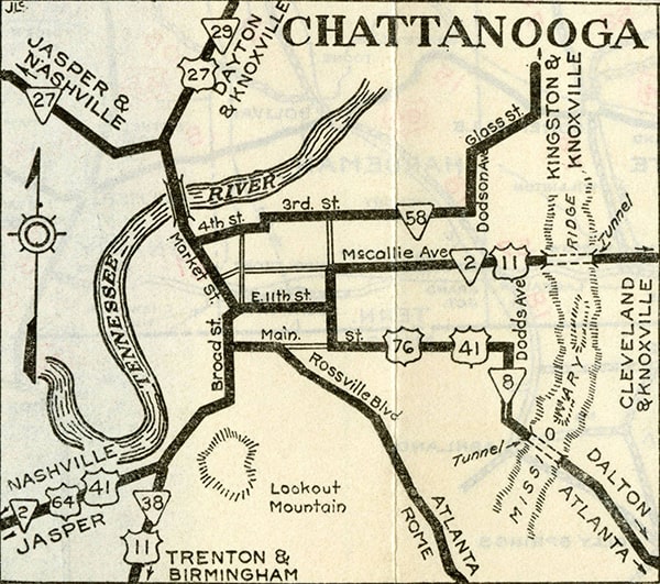
c. 1932, TNDoT
|
Then, starting in about 1935, US 72 began to the right (west) on 11th. That is the endpoint suggested by both of these next two maps...
|
c. 1938, TNDoT
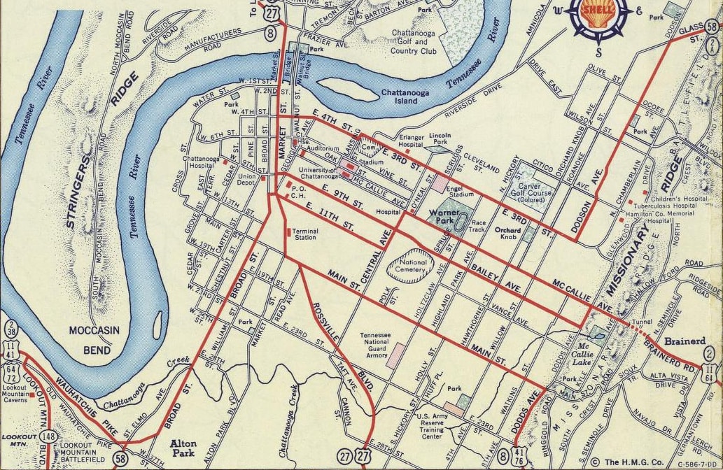
c. 1956, Gousha
...and we can be reasonably certain that US 76 was overlapped with US 27 north from Main because of this photo:
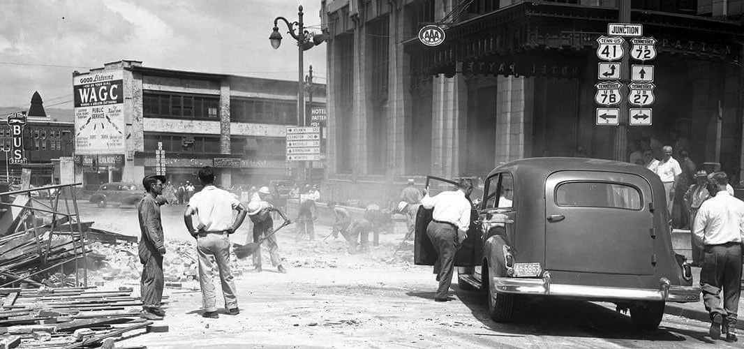
c. 1951, courtesy of Chattanooga History Center
|
That was looking west on 11th, which carried US 11-64. The junction assembly shown there indicates that at the upcoming intersection (Market), US 72 began straight ahead, and US 76 began to the left. In about three more blocks, Market has an intersection with Main, which carries US 41. Officially, US 76 joins US 41 by turning to the east on Main (but once again, no signage indicates this). About two blocks east on Main is the intersection with Rossville Avenue, where US 27 and US 76 diverged (Rossville is now closed to traffic at the railyards, but historically it was a through route). In about two more blocks (approaching Washington Street) is the first US 76 sign...
|
|
|
...or, more accurately: the first US 76 sign that is actually on US 76 (more on that below).
Now we will turn around and retrace our path back to the north. Directly across the street from the sign shown above is the last US 76 marker that is posted on the official US 76: |
|
|
In a couple blocks we arrive back at Rossville, where US 76 joined US 27. About two blocks that direction, US 76 officially turns north on Market... but, you guessed it: no signage to that effect. At this point, we are going to take a slight detour by continuing west on Main, where another perplexing sign was posted:
|
Google Maps Street View, 2008
|
|
That assembly was on Main at Cowart Street, and it implied that US 76 ended one block ahead, at Broad. However, that information had been incorrect since 2002, when the westernmost segment of US 76 was changed (and by 2013 that "End" sign had been removed). This photo shows the intersection at Broad, which is a former endpoint of US 76...
|
Nitzman, Jan. 2013 (same as of 2023)
|
|
...as well as the current terminus of US 72: the east beginning is to the left on Broad. But - no surprise - there is no signage indicating that at this intersection. If we turn left (south on Broad), the first reference to US 72 doesn't appear until several blocks later...
|
Turner, May 2023
|
...and heading the opposite direction (north on Broad), the last eastbound US 72 marker is posted at 18th Street:
|
Turner, May 2023
|
|
Continuing north on Broad, there is an assembly at 17th Street noting the end of US 72:
|
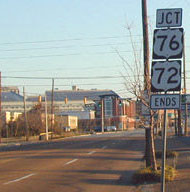
Wilson, Feb. 2002
|
Montgomery, July 2004 (same as of 2013)
|
Sanderson, Aug. 2018 (same as of 2023)
|
|
At the next block (16th Street), there is still a reference to US 76...
|

Nitzman, Jan. 2013 (same as of 2023)
|
...and if one makes that right turn onto Main, they are immediately greeted with a US 76 confirming assembly:
|
Nitzman, Jan. 2013 (same as of 2022)
|
The bottom line is: US 76 signage still abounds in the area surrounding its old endpoint, even though its routing was changed back in 2002. Now, if we continue about three blocks east, and then turn north on Market, we arrive at the perspective of this excellent historic photo:
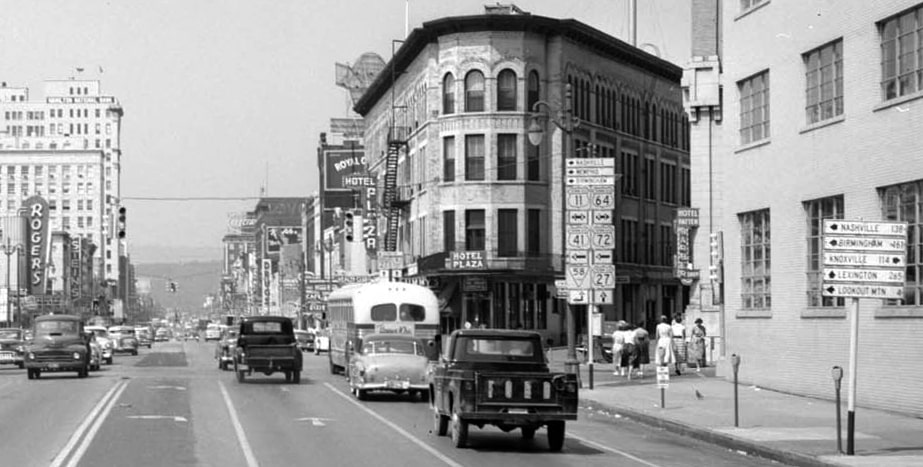
Mayo, date unknown, linked to source
At the time, that was the west end of US 76. Several years before this photo was taken, the south beginning of US 27 was straight ahead (the mileage sign at right indicated that Lexington was 265 miles in that direction). During that same timeframe (late 1920s to early '30s), the east beginning of US 64 was briefly to the left on 11th. And at the time of that photo, the east beginning of US 72 was still to the left on 11th (along with US 11-41-64; Nashville 138, Birmingham 161, and Lookout Mtn. 4). US 11-64 were also to the right (Knoxville 114). Next is a modern photo from that same perspective:

Sanderson, Aug. 2018
|
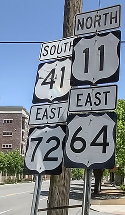
Wouldn't it be great if US routes through Chattanooga were still signposted as well as they were historically? This interactive image is looking east on 11th:
That is where US 64, and later US 72, ended at Market; US 76 began to the right.
|
|
Two blocks to the left (north on Market) we reach 9th (or MLK), which is the current official west end of US 76, and the official south beginning of US 127 is straight ahead:
|
Nitzman, Jan. 2013
|
|
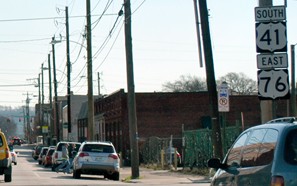
US 127 continues ahead, then turns left on Cherokee. That becomes Dayton, but there is no signage until the location shown in these photos:
|
Patriarca, summer 2003
|
Sanderson, Aug. 2018
|
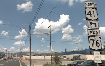
That was looking north on Dayton; Signal Mountain begins to the left. That is where original US 41 made a left turn -- US 27 may have begun straight ahead, but more likely that was simply where the two routes split. Likewise, when US 127 was later extended to Chattanooga, that is probably where it split from US 27. Old US 27 formerly continued northbound straight ahead. But now both northbound Business 27 and US 127 continue left to the interchange with the modern US 27 freeway. Just beyond that junction is the first US 127 confirming marker...
Nitzman, June 2005
|
Brian556, June 2012 (still there as of 2018)
|
The green sign below the "Begin" tab is a mockingbird, denoting one of Tennessee's official scenic routes. One more US route still needs to be mentioned: in 1987 the US 74 designation was officially extended to Chattanooga. However, signage ends in Cleveland TN; more info and photos on the main US 74 page.
Research and/or photo credits: Brian556; Robert Droz; Adam Froehlig; Eric Lachmiller; Perry Mayo; J.P. Nasiatka; Alex Nitzman; Chris Patriarca; Mike Roberson; Dale Sanderson; Jim Teresco; Charles Turner; Ed Wilson; Morgan Younce
Page originally created 2008;
last updated May 9, 2023.
last updated May 9, 2023.
