US Ends .com
  • Home
  • Store
    • US highway map
    • Florida US highway map
  • Endpoints
    • US 1 - US 9 >
      • 1 >
        • 201
        • 301
        • 401 [i]
        • 401 [ii]
        • 401
        • 501
        • 601
        • 701
      • 2w >
        • 102
      • 2e >
        • 202
        • 302
      • 3
      • 4 >
        • 104
      • 5
      • 6 >
        • 106
        • 206
      • 7
      • 8
      • 9 >
        • 109*
        • 209
        • 309
    • US 10 - US 19 >
      • 10 >
        • 110
        • 210
        • 310
        • 410
      • 11 >
        • 111
        • 211
        • 311
        • 411 [i]
        • 411 [ii]
        • 411
        • 511*
        • 611
        • 711*
      • 12 >
        • 112
        • 212
        • 312
      • 13 >
        • 113
        • 213
      • 14
      • 15
      • 16 >
        • 116
        • 216
      • 17 >
        • 17-1
        • 117 [i]
        • 117
        • 217
      • 18 >
        • 118
        • 218
      • 19 >
        • 119
        • 219
        • 319
    • US 20 - US 29 >
      • 20e >
        • 120
        • 220
        • 320
        • 420
      • 20w
      • 21 >
        • 121 [i]
        • 121
        • 221
        • 321
        • 421
        • 521
      • 22 >
        • 122 [i]
        • 122 [ii]
        • 222
        • 322
        • 422e
        • 422w
        • 522
        • 622*
      • 23 >
        • 123 [i]
        • 123
        • 223
      • 24 >
        • 124
        • 224
      • 25
      • 26 >
        • 126
      • 27 >
        • 127
        • 227
      • 28
      • 29 >
        • 129
    • US 30 - US 39 >
      • 30 >
        • 130
        • 230
        • 330
        • 430
        • 530
        • 630*
        • 730
        • 830
      • 31 >
        • 131
        • 231
        • 331 [i]
        • 331
        • 431
      • 32
      • 33
      • 34
      • 35
      • 36 >
        • 136
      • 38 >
        • 138
    • US 40 - US 49 >
      • 40 >
        • 140
        • 240
        • 340
      • 41 >
        • 141
        • 241 [i]
        • 241 [ii]
        • 341
        • 441 >
          • 441n
          • 441s
        • 541
        • 641
      • 42
      • 43
      • 44
      • 45
      • 46
      • 48 [i]
      • 48 [ii]
      • 48
      • 49
    • US 50 - US 59 >
      • 50 >
        • 150
        • 250
        • 350
        • 450
        • 550
        • 650
      • 51 - 55 >
        • 51 >
          • 151
        • 52 >
          • 152
        • 53
        • 54 >
          • 154
        • 55
      • 56 >
        • 156
      • 57
      • 58 >
        • 158
        • 258
      • 59 >
        • 159
        • 259
    • US 60 - US 69 >
      • 60 >
        • 160
        • 260
        • 360
        • 460
      • 61 - 65 >
        • 61 >
          • 161
        • 62
        • 63 >
          • 163 [i]
        • 64 >
          • 164 [i]
          • 164 [ii]
          • 264
        • 65 >
          • 165
      • 66 >
        • 166
        • 266
        • 366 [i]
        • 366 [ii]
        • 466
        • 566
        • 666
      • 67 >
        • 167
      • 68 >
        • 168
      • 69 >
        • 169
    • US 70 - US 79 >
      • 70 >
        • 170
        • 270 [i]*
        • 270
        • 370
        • 470
      • 71 >
        • 171
        • 271
        • 371 [i]
        • 371
      • 72 - 76 >
        • 72
        • 73
        • 74
        • 75 >
          • 175
          • 275
        • 76 >
          • 176
          • 276
      • 77 >
        • 177
        • 277
        • 377
      • 78 >
        • 178
        • 278
        • 378
      • 79
    • US 80 - US 89 >
      • 80 - 84 >
        • 80 >
          • 180 [i]
          • 180
          • 280
          • 380
        • 81 >
          • 181
          • 281
        • 82
        • 83 >
          • 183
          • 283
          • 383
        • 84
      • 85 - 89 >
        • 85 >
          • 185
          • 285 [i]
          • 285
          • 385 [i]
          • 385
          • 485
        • 87 >
          • 187
          • 287n
          • 287s
        • 89n
        • 89s >
          • 189 [i]
          • 189
    • US 90 - US 99 >
      • 90 - 94 >
        • 90 >
          • 190
          • 290
        • 91 >
          • 191 >
            • 191n
            • 191s
          • 491
        • 92 >
          • 192
        • 93
        • 94
      • 95 -98 >
        • 95 >
          • 195
          • 295
          • 395
        • 96 [i]
        • 96
        • 97 >
          • 197
        • 98
      • 99 >
        • 199
        • 299
        • 399
    • Anomalies >
      • 101
      • 163
      • 400
      • 412
      • 425
  • Places
    • A-L >
      • A >
        • Aberdeen
        • Albuquerque
        • Amarillo
        • Apalachicola
        • Astoria
        • Atlantic
      • B >
        • Baltimore
        • Baton Rouge
        • Bay Area
        • Bishop
        • Boone
        • Brady
        • Bristol
        • Brownsville
        • Brunswick
      • C >
        • Charleston
        • Chattanooga
        • Chicago
        • Cincinnati
        • Cleveland
        • Cody
        • Corpus
        • Cortez
        • Council Bluffs
        • Covington
        • Crescent
        • Cumberland Gap
      • D-E >
        • Dallas
        • Des Moines
        • Detroit
        • Dothan
        • Douglas
        • El Paso
        • Eugene
        • Erie
      • F >
        • Farmington
        • Flagstaff
        • Florence
        • Fox Valley
        • Franklin
      • G >
        • Gallup
        • Grand Junction
        • Grand Portage
        • Grayling
        • Great Falls
        • Greeley
      • H-I >
        • Hardeeville
        • Harrisburg
        • Holbrook
        • Idaho Falls
        • Int'l Falls
      • J-K >
        • Jacksonville
        • Joplin
        • Junction
        • Kansas City
        • Keokuk
        • Key West
        • Kingman
      • L >
        • Laredo
        • Lewiston
        • Long Beach
        • Los Angeles
        • Louisville
        • Lubbock
    • M-R >
      • M >
        • Mackinaw
        • Madison
        • Maryhill
        • Maysville
        • Miami
        • Midway
        • Miles City
        • Milford
        • Milwaukee
        • Minneapolis
        • Mobile 31
        • Mobile 31-43-45
        • Montgomery
        • Monticello
        • Mount Vernon
      • N-O >
        • Nags Head
        • Naples
        • Natchez
        • New Castle
        • New Orleans
        • Niagara
        • Norlina
        • Ocean City
        • Oklahoma City
      • P >
        • Pee Dee
        • Pembina
        • Pensacola
        • Petersburg
        • Philadelphia
        • Piegan
        • Pineville
        • Port Arthur
        • Portsmouth
      • Q-R >
        • Quad Cities
        • Rapid City
        • Raton
        • Reading
        • Richmond
        • Rockingham
        • Rouses Point
    • S-Z >
      • S >
        • San Antonio
        • San Antonio NM
        • San Diego
        • Santa Fe
        • Savannah
        • Sioux
        • Springer
        • Springfield
        • St. Ignace
        • St. John
        • St. Paul
        • St. Pete
      • T-U-V >
        • Tallahassee
        • Tampa
        • Toledo
        • Trinidad
        • Ucolo
        • VA Beach
      • W >
        • Walterboro
        • Waverly
        • West Memphis
        • Wilmington
        • Wilson
        • Wrightsville
      • Y >
        • Yellowstone E
        • Yellowstone N
        • Yellowstone NE
        • Yellowstone S
        • Yellowstone W
  • Highways
    • Map of all endpoints
    • Sources
    • History
    • 1926 almost-routes
    • Intra-state routes
    • Numbering
    • Colors
    • Gaps
    • Blog
  • Bonus
    • Colorado >
      • Lowest point
      • Antipodes
      • Toponymy >
        • Roots
      • Colloquialisms
      • Populations
      • Denvers
    • Washington Meridian
    • Watersheds >
      • Headwaters Hill
      • Three Waters Mtn.
      • Parting of the Waters
    • Geo-centers >
      • 48 states
      • 50 states
      • North America
    • State corners >
      • AZ-CO-NM-UT
      • CO-UT-WY
      • CO-NE-WY
      • CO northeast
      • CO-KS-NE
      • CO-KS-OK
      • CO-NM-OK
      • NM-OK-TX
      • NM southeast
      • TX northwest
    • ooss.space
  • Connect
    • Author/history
    • Rationale
    • Contact
    • Contributors
    • Submissions

Idaho
​falls

Historic US highway endpoints in Idaho Falls, ID

Get your very own map showing all current and historic US routes!

Today US 91 ends south of downtown Idaho Falls.  But during much of the route's existence, it continued north through downtown, and on to Montana.  This photo was taken looking north on Yellowstone Avenue:
Picture
Elbert, Mar. 2006 (unchanged as of 2017)

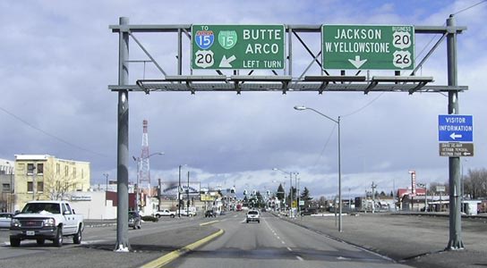
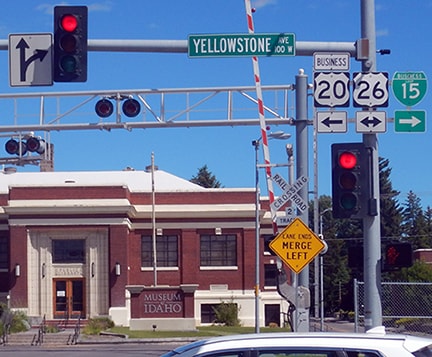
​That is now eastbound US 26 (which continues straight) and northbound Business Loop I-15 (which turns left at Broadway, the signal ahead).  Originally US 91 turned left on Broadway as well, crossing the Snake River and then continuing north along its west bank.  At the time, that direction was also westbound US 20, while eastbound was straight ahead.  Also straight ahead was the south beginning of US 191:
Picture
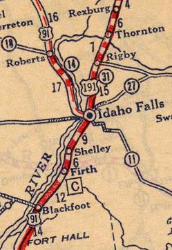
c. 1927, Rand McNally
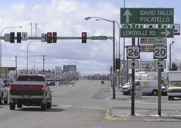
Just over a mile in that direction, travelers come to the junction pictured here: 
Picture
Elbert, Mar. 2006 (unchanged as of 2017)
By this point, Yellowstone Av has become "Northgate Mile".  Eastbound Business US 20 continues by angling to the left on Holmes Avenue, while US 26 continues straight via Northgate Mile.  Today's BL 20 used to be mainline US 20-191, and for a very brief time during the early 1950s, straight ahead may have been the west beginning of US 26 (although it seems more likely that US 26 would have been overlapped with US 20 to the US 91 junction, pictured above).  The next photo is looking the opposite direction (southwest on Northgate Mile):
Picture
Elbert, Mar. 2006 (unchanged as of 2017)

​That may have been a short-lived endpoint of US 26.  Before that, US 20 and US 191 came in together from the right, and continued ahead.  The US 191 designation would have ended at Broadway, where it junctioned with its "parent" route (US 91):
Picture
Elbert, Mar. 2006 (unchanged as of 2017)
Westbound US 20 continued to the right, and northbound US 91 was also that direction.  Straight ahead was southbound US 91.  ​​
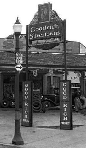
This historic photo was taken from the same intersection.  The US 191 shield was for traffic heading west on Broadway, indicating that route began to the right (north) on Yellowstone:
Picture
(date and attribution unknown)

This next photo shows that same intersection from the perspective of a driver heading the opposite direction (east on Broadway).  Historically, this would have marked the split between southbound US 91 (which continued to the right on Yellowstone) and eastbound US 20 (which continued to the left).  Also to the left was the south beginning of US 191:
Picture
Barnes, June 2017
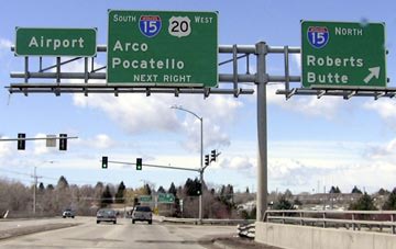
Later on, for about 30 years, US 191 was extended south into Utah.  But then in 1972, it was truncated once again to Idaho Falls.  It is possible that its endpoint was at one of the historic junctions shown above.  But if that was ever the case, it was probably short-lived, because by 1976 (maybe earlier), the US 20 freeway had been built along the north edge of town.  It seems likely that US 191 traffic would have been directed to stay on that road, and that the designation would have ended at the junction with I-15 (interchange 119):
Picture
Elbert, Mar. 2006
Westbound US 20 continues by heading south on I-15 to the next exit (Broadway), but US 191 probably ended here until 1981, which is when it was completely removed from Idaho and instead extended through Wyoming, Utah, and Arizona.  (By the way, the northbound control point is not "Roberts Butte" -- rather, the reference is to Roberts ID and Butte MT.)  Right about the same time US 191 was moved out of Idaho, the designation of its "parent" (US 91) was truncated to the Idaho Falls area:
Picture
Elbert, Mar. 2006
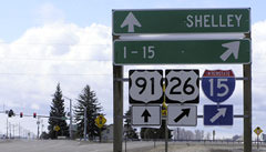
​That was looking north on Yellowstone Highway; the crossroad is 65th Street South.  Downtown Idaho Falls is about four miles ahead; and about two miles to the left is I-15's interchange 113.  Heading east from that interchange, the north beginning of US 91 was posted thus:
Picture
Elbert, Mar. 2006
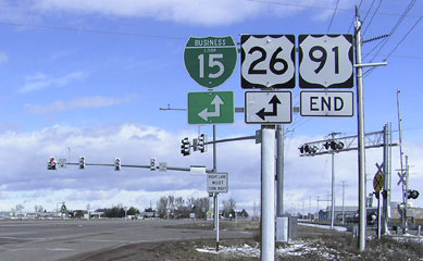
That was from the perspective of eastbound US 26/northbound BL 15.  To the right is a slip ramp to US 91, although the junction ahead is not grade-separated.  And if one were to continue straight, they would encounter a sign assembly with more complete information: 
Picture
Elbert, Mar. 2006
​The stop sign in the background is for traffic on the aforementioned slip ramp.  There was a similar setup heading south on Yellowstone:
Picture
Elbert, Mar. 2006
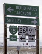
Southbound drivers wanting to continue on westbound US 26/southbound BL 15 could use the ramp to the right, but directions were also provided at the 65th Street intersection itself...
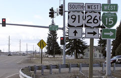
Picture
Elbert, Mar. 2006
...although that should have been "South BL 15".  If a driver continued straight ahead, they were on the north beginning of US 91, and were soon greeted with the first confirming sign:
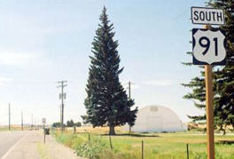
Picture
Elbert, 2003
​Even traffic heading west on 65th Street (which is not a signed highway) was made aware of the routes signed through this intersection:
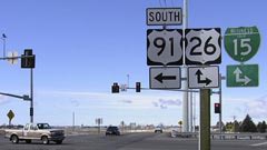
Picture
Elbert, Mar. 2006
Later that year (2006), the terminus of US 91 was moved to its current location (more info on the main US 91 page).
main US 26 page
main US 91 page
main US 191 page
Research and/or photo credits: Joseph Barnes; ​Chris Elbert; Mike Roberson; Dale Sanderson
Page originally created 2006;
last updated Sep. 1, 2019.
Copyright © 1998-2023
Picture