US Ends .com
  • Home
  • Store
    • US highway map
    • Florida US highway map
  • Endpoints
    • US 1 - US 9 >
      • 1 >
        • 201
        • 301
        • 401 [i]
        • 401 [ii]
        • 401
        • 501
        • 601
        • 701
      • 2w >
        • 102
      • 2e >
        • 202
        • 302
      • 3
      • 4 >
        • 104
      • 5
      • 6 >
        • 106
        • 206
      • 7
      • 8
      • 9 >
        • 109*
        • 209
        • 309
    • US 10 - US 19 >
      • 10 >
        • 110
        • 210
        • 310
        • 410
      • 11 >
        • 111
        • 211
        • 311
        • 411 [i]
        • 411 [ii]
        • 411
        • 511*
        • 611
        • 711*
      • 12 >
        • 112
        • 212
        • 312
      • 13 >
        • 113
        • 213
      • 14
      • 15
      • 16 >
        • 116
        • 216
      • 17 >
        • 17-1
        • 117 [i]
        • 117
        • 217
      • 18 >
        • 118
        • 218
      • 19 >
        • 119
        • 219
        • 319
    • US 20 - US 29 >
      • 20 >
        • 120
        • 220
        • 320
        • 420
      • 21 >
        • 121 [i]
        • 121
        • 221
        • 321
        • 421
        • 521
      • 22 >
        • 122 [i]
        • 122 [ii]
        • 222
        • 322
        • 422e
        • 422w
        • 522
        • 622*
      • 23 >
        • 123 [i]
        • 123
        • 223
      • 24 >
        • 124
        • 224
      • 25
      • 26 >
        • 126
      • 27 >
        • 127
        • 227
      • 28
      • 29 >
        • 129
    • US 30 - US 39 >
      • 30 >
        • 130
        • 230
        • 330
        • 430
        • 530
        • 630*
        • 730
        • 830
      • 31 >
        • 131
        • 231
        • 331 [i]
        • 331
        • 431
      • 32
      • 33
      • 34
      • 35
      • 36 >
        • 136
      • 38 >
        • 138
    • US 40 - US 49 >
      • 40 >
        • 140
        • 240
        • 340
      • 41 >
        • 141
        • 241 [i]
        • 241 [ii]
        • 341
        • 441
        • 541
        • 641
      • 42
      • 43
      • 44
      • 45
      • 46
      • 48 [i]
      • 48 [ii]
      • 48
      • 49
    • US 50 - US 59 >
      • 50 >
        • 150
        • 250
        • 350
        • 450
        • 550
        • 650
      • 51 - 55 >
        • 51 >
          • 151
        • 52 >
          • 152
        • 53
        • 54 >
          • 154
        • 55
      • 56 >
        • 156
      • 57
      • 58 >
        • 158
        • 258
      • 59 >
        • 159
        • 259
    • US 60 - US 69 >
      • 60 >
        • 160
        • 260
        • 360
        • 460
      • 61 - 65 >
        • 61 >
          • 161
        • 62
        • 63 >
          • 163 [i]
        • 64 >
          • 164 [i]
          • 164 [ii]
          • 264
        • 65 >
          • 165
      • 66 >
        • 166
        • 266
        • 366 [i]
        • 366 [ii]
        • 466
        • 566
        • 666
      • 67 >
        • 167
      • 68 >
        • 168
      • 69 >
        • 169
    • US 70 - US 79 >
      • 70 >
        • 170
        • 270 [i]*
        • 270
        • 370
        • 470
      • 71 >
        • 171
        • 271
        • 371 [i]
        • 371
      • 72 - 76 >
        • 72
        • 73
        • 74
        • 75 >
          • 175
          • 275
        • 76 >
          • 176
          • 276
      • 77 >
        • 177
        • 277
        • 377
      • 78 >
        • 178
        • 278
        • 378
      • 79
    • US 80 - US 89 >
      • 80 - 84 >
        • 80 >
          • 180 [i]
          • 180
          • 280
          • 380
        • 81 >
          • 181
          • 281
        • 82
        • 83 >
          • 183
          • 283
          • 383
        • 84
      • 85 - 89 >
        • 85 >
          • 185
          • 285 [i]
          • 285
          • 385 [i]
          • 385
          • 485
        • 87 >
          • 187
          • 287
        • 89 >
          • 189 [i]
          • 189
    • US 90 - US 99 >
      • 90 - 94 >
        • 90 >
          • 190
          • 290
        • 91 >
          • 191
          • 491
        • 92 >
          • 192
        • 93
        • 94
      • 95 -98 >
        • 95 >
          • 195
          • 295
          • 395
        • 96 [i]
        • 96
        • 97 >
          • 197
        • 98
      • 99 >
        • 199
        • 299
        • 399
    • Anomalies >
      • 101
      • 163
      • 400
      • 412
      • 425
  • Places
    • A-L >
      • A >
        • Aberdeen
        • Albuquerque
        • Amarillo
        • Apalachicola
        • Astoria
        • Atlantic
      • B >
        • Baltimore
        • Baton Rouge
        • Bay Area
        • Bishop
        • Boone
        • Brady
        • Bristol
        • Brownsville
        • Brunswick
      • C >
        • Charleston
        • Chattanooga
        • Chicago
        • Cincinnati
        • Cleveland
        • Cody
        • Corpus
        • Cortez
        • Council Bluffs
        • Covington
        • Crescent
        • Cumberland Gap
      • D-E >
        • Dallas
        • Des Moines
        • Detroit
        • Dothan
        • Douglas
        • El Paso
        • Eugene
        • Erie
      • F >
        • Farmington
        • Flagstaff
        • Florence
        • Fox Valley
        • Franklin
      • G >
        • Gallup
        • Grand Junction
        • Grand Portage
        • Grayling
        • Great Falls
        • Greeley
      • H-I >
        • Hardeeville
        • Harrisburg
        • Holbrook
        • Idaho Falls
        • Int'l Falls
      • J-K >
        • Jacksonville
        • Joplin
        • Junction
        • Kansas City
        • Keokuk
        • Key West
        • Kingman
      • L >
        • Laredo
        • Lewiston
        • Long Beach
        • Los Angeles
        • Louisville
        • Lubbock
    • M-R >
      • M >
        • Mackinaw
        • Madison
        • Maryhill
        • Maysville
        • Miami
        • Midway
        • Miles City
        • Milford
        • Milwaukee
        • Minneapolis
        • Mobile 31
        • Mobile 31-43-45
        • Montgomery
        • Monticello
        • Mount Vernon
      • N-O >
        • Nags Head
        • Naples
        • Natchez
        • New Castle
        • New Orleans
        • Niagara
        • Norlina
        • Ocean City
        • Oklahoma City
      • P >
        • Pee Dee
        • Pembina
        • Pensacola
        • Petersburg
        • Philadelphia
        • Piegan
        • Pineville
        • Port Arthur
        • Portsmouth
      • Q-R >
        • Quad Cities
        • Rapid City
        • Raton
        • Reading
        • Richmond
        • Rockingham
        • Rouses Point
    • S-Z >
      • S >
        • San Antonio
        • San Antonio NM
        • San Diego
        • Santa Fe
        • Savannah
        • Sioux
        • Springer
        • Springfield
        • St. Ignace
        • St. John
        • St. Paul
        • St. Pete
      • T-U-V >
        • Tallahassee
        • Tampa
        • Toledo
        • Trinidad
        • Ucolo
        • VA Beach
      • W >
        • Walterboro
        • Waverly
        • West Memphis
        • Wilmington
        • Wilson
        • Wrightsville
      • Y >
        • Yellowstone E
        • Yellowstone N
        • Yellowstone NE
        • Yellowstone S
        • Yellowstone W
  • Highways
    • Map of all endpoints
    • Sources
    • History
    • 1926 almost-routes
    • Intra-state routes
    • Numbering
    • Colors
    • Blog
  • Bonus
    • Colorado >
      • Lowest point
      • Antipodes
      • Toponymy >
        • Roots
      • Colloquialisms
      • Populations
      • Denvers
    • Washington Meridian
    • Watersheds >
      • Headwaters Hill
      • Three Waters Mtn.
      • Parting of the Waters
    • Geo-centers >
      • 48 states
      • 50 states
      • North America
    • State corners >
      • AZ-CO-NM-UT
      • CO-UT-WY
      • CO-NE-WY
      • CO northeast
      • CO-KS-NE
      • CO-KS-OK
      • CO-NM-OK
      • NM-OK-TX
      • NM southeast
      • TX northwest
    • ooss.space
  • Connect
    • Author/history
    • Rationale
    • Contact
    • Contributors
    • Submissions

US 197

End of US highway 197
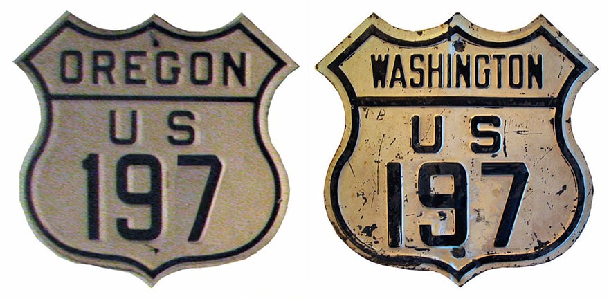
View a map showing this route.
Get your very own map showing all current and historic US routes!
Picture
Summa
1952-1968
  • North: near Maryhill, WA
  • South: Shaniko Jct. OR
1968-present
  • North: near Dallesport, WA
  • South: Shaniko Jct. OR
Mileage: in 1989 AASHTO listed a figure of 82 miles for US 197... but that was still assuming a Maryhill terminus.  US 197 had long since been truncated to Dallesport, and our own 2020 measurement yielded 63.3 miles.  

US 197 was commissioned in 1952 -- presumably at the suggestion of Oregon officials, who probably wanted a north-south US route to serve The Dalles.  From its junction with US 97 near Shaniko, US 197 went north through Maupin and The Dalles to US 830 (now WA hwy. 14), as it does today.  But from there, originally it was co-signed east with 830 to the junction with US 97, where both routes shared a common terminus (photos and more info on the Maryhill page).  At the time, US 97 traffic was still being ferried across the Columbia from Biggs OR, to continue north through Goldendale to Yakima.  But today's bridge was planned (if not already under construction).  So now there is no ferry, US 830 does not exist, and US 197 no longer serves Maryhill.  That is probably because WSDoT never had much interest in US 197 -- certainly not the segment that was overlapped with US 830.  Apparently they were a good neighbor to Oregon, and signed it anyway for the first 16-or-so years.  US 830 was decommissioned in 1967 and replaced by WA 14.  So it is possible that when WSDoT removed the US 830 signs, they also removed the US 197 signs between Maryhill and Dallesport at the same time.  However, the official state highway map continued to mark that segment as US 197 until 1970.  That was the same year that Washington changed some of its laws describing state highway routings, and that may have been the process that resulted in the truncation of US 197 to its present terminus.  At any rate, it was not until 2006 that WSDoT asked AASHTO to officially decommission that segment, so after almost 40 years the official endpoint of US 197 became the same as the signed endpoint.
So that explains why the north end of US 197 is at a junction with a state route.  Dallesport is across the Columbia River from The Dalles OR; these photos were taken from westbound WA hwy. 14:
Picture
Elbert, Aug. 2004
Picture
Morrison, Jan. 2019
That is between Murdock and Wishram; the north beginning of US 197 is to the left (despite that newer sign that mistakenly refers to US 197 as a state route).  Next we are looking the opposite direction:
Picture
Wiley
Turning right, one sees the view shown here, which includes the first southbound confirming marker:
Picture
Elbert, Aug. 2004
In about three miles, the highway crosses the Columbia (the banks of which are visible in the distance, with The Dalles on the far side).  Shortly after entering Oregon, travelers reach I-84's interchange 87.  

​This photo was taken from the opposite direction, and shows the north end of US 197:
Picture
Elbert, Aug. 2004 (unchanged as of 2019)

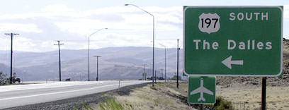
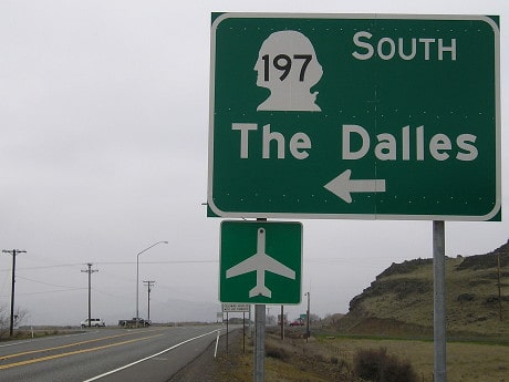
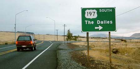
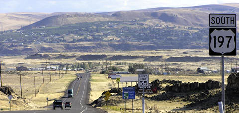
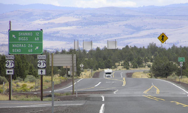
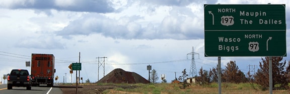
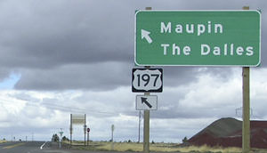
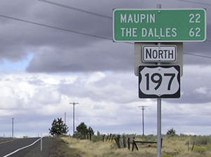
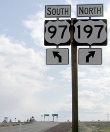
The route's south end is at a place called Shaniko Junction (which is not marked on most maps; the first town on 197 is Maupin, 22 miles north).  This photo was looking south at the end of US 197:
Picture
Elbert, Aug. 2004
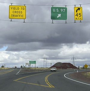
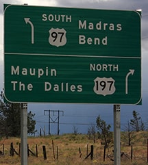
The RV shown in that photo was heading north on US 97; the driver was passing the signs shown here:
Picture
Elbert, Aug. 2004
Picture
Elbert, June 2016
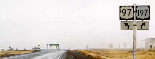
Note the three-digit number on a two-digit blank; additional examples are shown in some photos below.  But as of 2010, all of those have been replaced with more standard three-digit versions.  The signage in the distance is shown close-up here:
Picture
Elbert, Aug. 2004 (unchanged as of 2010)
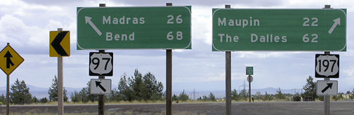
US 97 veers right; straight ahead is the south beginning of US 197 (but drivers must treat it as a left turn).  The sign in the distance is shown here:
Picture
Elbert, Aug. 2004
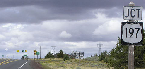
​The backside of the sign in the distance is the same sign shown in the first photo of Shaniko Jct.  Not far ahead from there is the first northbound confirming marker:
Picture
Elbert, Aug. 2004
These shots were looking southbound on US 97 at the same junction:
Picture
Wiley
Picture
Elbert, Apr. 2010
Picture
Elbert, June 2016
The signage in the distance is shown close-up here; to turn right is to head north at the south beginning of US 197:
Picture
Elbert, Aug. 2004 (US 197 shield replaced by 2010)

Research and/or photo credits: Mark Bozanich; Chris Elbert; Jeff Morrison; Dale Sanderson; Michael Summa; Mike Wiley
Page originally created 2000;
last updated Dec. 30, 2021.
Copyright © 1998-2023
Picture