Current and historic US Highway ends in Rouses Point and Champlain, NY
|
Rouses Point is notable in US highway history, because despite being a rather small town, its location was significant enough that three US highways converged and ended there: US 9, US 11, and US 2 [eastern segment].
|
 |
|
However, US 2[e] did not quite make it to Rouses Point initially. It was one of several US routes that New York refused to "accept" from neighboring states, so AASHO's 1927 route log described its endpoint as the state line:
|
c. 1927, AASHO
|
|
At the time, there was no bridge over Lake Champlain connecting Rouses Point and Alburgh VT. Instead there was a car ferry that crossed between Rouses Point and Windmill Point VT. This historical marker was posted near the former ferry landing in Rouses Point:
|
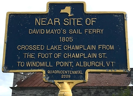
(attribution unknown)
|
|
So technically US 2's west terminus was in open water, in the middle of a ferry segment. But more practically we could describe US 2's endpoint as the Windmill Point ferry landing (no longer extant). That arrangement was illustrated on this early map:
|
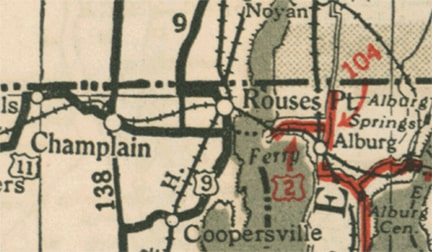
National Survey Co. (date unknown but pre-1935)
|
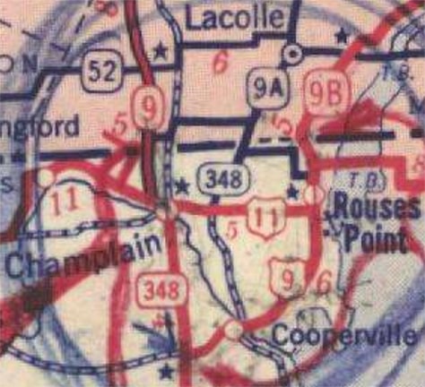
We will come back to US 2 later, but for now let us examine the original endpoints of the other two routes shown there: US 9 and US 11. Notice how US 9 was shown heading north of Rouses Point, then turning west along the Canada border, then crossing at a point between Rouses Point and Champlain (we will explore that again later). In the initial route log, US 9 was explicitly described as going to the Canada border, but US 11 was not...
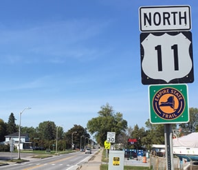
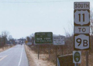
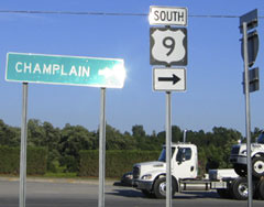
...so we conclude that US 11 must have ended at its junction with US 9. Where was that? US 11 came into Rouses Point from Champlain on the aptly-named Champlain Street (as it still does today), ending at Lake Street (which carried US 9). Here are some photos of modern signage looking east on Champlain:
|
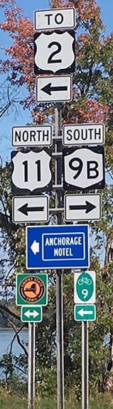
Bourey, Sep. 2019
|
|
US 11 originally ended there, while US 9 ran both directions along Lake (the crossroad).
These next photos were taken looking northbound on Lake (old US 9). Today northbound US 11 continues straight ahead, but originally its north beginning was to the left on Champlain, whereas US 9 continued ahead: |
Field/Nitzman, July 2000
|
Bourey, Sep. 2019
|
|
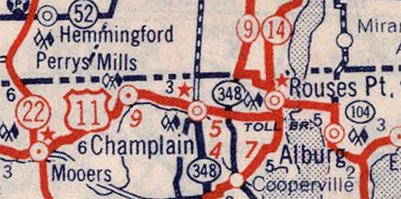
So where did US 9 end? It would be easy to assume that US 9 continued north on what is now US 11, ending at the Canada border crossing that connects with Quebec highway 223. However, historic maps actually do not bear that out. Remember in the map above we observed that US 9 was shown to cross into Canada at a location between Rouses Point and Champlain? That corresponds with the border crossing that connects today's NY hwy. 276 and Quebec hwy. 221. Early maps suggest that this western/221 crossing was actually the primary border crossing at the time. For example, this next map shows both border crossings north of Rouses Point. The road shown as Quebec 14 corresponds with today's eastern/223 crossing, and the highway shown as Quebec 9 corresponds with today's western/221 crossing. We can assume the red line shown at the western/221 crossing was US 9 because it is apparent that New York and Quebec coordinated their highway designations such that both Route 9's connected at a common border crossing:
|
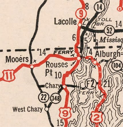
c. 1934, Rand McNally
|
|
So initially US 9 ended at the western/221 crossing. This image was looking west along the border (a boundary obelisk is visible in the lower right corner). US 9 ended at the stop sign: to the right is the border crossing, and to the left is NY hwy. 276 (formerly NY 348, as shown on several historic maps that follow):
|
Google Maps Street View, July 2012
|
Now, to briefly go back to US 2: the first bridge across Lake Champlain connecting Rouses Point to Alburgh opened in 1937. Although I have yet to find any proof of this, it is likely that is the timeframe when New York began signposting its one-mile segment of US 2. These photos were taken looking west on Bridge Road, approaching Lake St:
Field/Nitzman, July 2000
|
Bourey, Sep. 2019
|
Bourey, Sep. 2019
|
That is the current endpoint of US 2[e], and I suspect that has not changed since 1937 (I have not seen any evidence that US 2 was ever extended beyond that point, for example to the border crossing). But that brings up a question: what was the designation of this segment of Lake Street, where US 2 ended? It would have been unusual to have a US route ending at a junction with a state highway...
|
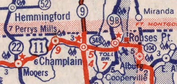
...and as a matter of fact I suspect that is precisely what prompted New York to extend the US 11 designation north to the eastern/223 border crossing. Maps from a few years later (1939 for example, as well as the 1940 shown next) illustrated the new US 2 bridge, and also began to suggest that both border crossings were served by US routes...
|
c. 1940, Rand McNally
|
|
...and that was explicitly depicted on this 1942 map, which not only showed that US 9 still served the western/221 border crossing, but also that US 11 had been extended to the eastern/223 crossing, with US 2 ending at US 11:
|
c. 1942, Clinton Co. NY
|
|
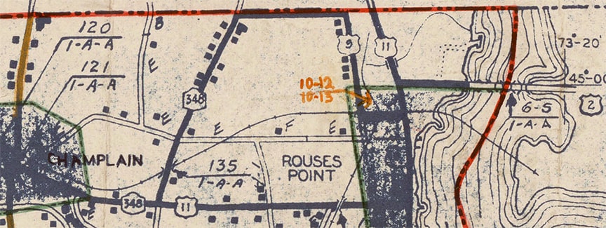
There are at least a couple maps from later in that same decade that suggest US 9 was moved away from the western/221 crossing, and instead shared the eastern/223 crossing with US 11. One example is the 1943 USGS topo:
|

c. 1943, USGS
|
|
Note that "1943" indicates the year that the aerial photos were taken, but the actual cartography could have been done a couple years later. There, US 9 was shown at the eastern border crossing, but curiously not US 11.
It appears this was the timeframe during which the eastern/223 border crossing became primary, and the western/221 crossing became secondary. That is suggested by this map, which clearly showed US route(s) at the eastern/223 crossing, but only state routes at the western/221 crossing... |
date unknown but probably 1946
|
|
...but at any rate US 9 did not last long in that location. The next year (1947), US 9 was rerouted north of Chazy NY. Instead of going northeast through Coopersville to Rouses Point (via today's NY 9B), US 9 traffic was redirected more northerly through Champlain, ending at the border crossing north of town. That change was made in response to Quebec's rerouting of hwy. 9 to the west. That was illustrated on the next edition of the USGS topo (1956; the solid red line running east-west was US 11's route at the time):
|

c. 1956, USGS
|
|
So US 9's new terminus was at essentially the same location as the modern terminus of I-87 at the Canada border. That change was illustrated on this map that was published the following year...
|
c. 1948, Rand McNally
|
|
...but that was not the only thing that changed. Notice to the north of Rouses Point, it was only state route 9B that went to the Canada border (no US route). That was corroborated on many maps for the next several years, including on the 1956 USGS topo as well as on commercial maps:
|

c. 1956, USGS
|
c. 1959, Gousha
|
In that Gousha map series, the legend clearly differentiated US routes as red lines with blue casing, while state routes were red or blue lines with no casing. So it seems clear that US 2 and US 11 ended at their common junction, while it was only NY 9B that actually served the border crossing. Why would New York retract the US 11 designation from the border crossing? Well, clearly Quebec and New York were continuing to coordinate their route numbers, as evidenced by the fact that both jurisdictions re-designated their route departing from the international boundary as "Route 9B". On the route heading south from the border crossing, New York opted to use only the 9B designation, eliminating the US 11 designation possibly in an attempt to minimize potential driver confusion.
|
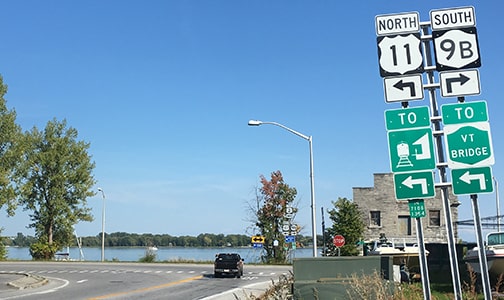
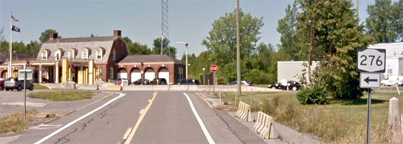
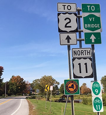
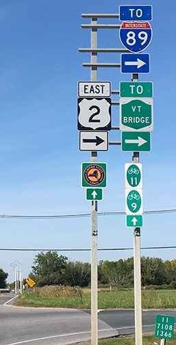
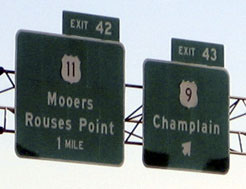
Here are some photos from that area. Heading north from Champlain on Lake is a reference to the upcoming junction with US 2:
Bourey, Sep. 2019
|
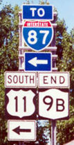
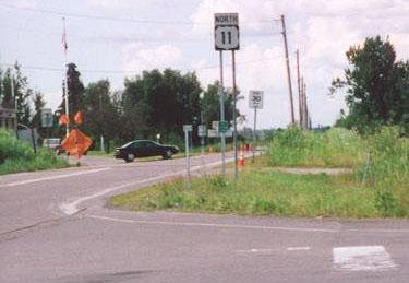
But first we reach what was the last US 11 marker as of 2019 (just past the jct. with NY 276 / original US 9):
Bourey, Sep. 2019
Shortly we come to the Bridge Road intersection, which is shown in these next photos:
|

Field/Nitzman, July 2000
|
Bourey, Sep. 2019
|
So US 2[e] begins to the right, and for several years that was also the perspective of a driver at the north end of US 11 (with only NY 9B continuing ahead). In roughly 1970, Quebec re-designated many of its highways. The former Route 9A heading north from the western border crossing became Route 221, and the former Route 9B heading north from the eastern crossing became Route 223.
|
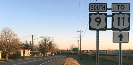
That removed any compelling reason for New York to use only the 9B designation at the eastern border crossing, so I suspect it was during this timeframe that New York re-extended the US 11 designation to the border, where it remains to this day. (For the first several years US 11 was co-signed with NY 9B, but that designation was truncated to its current terminus [shown previously] in roughly 1985.) Continuing north from the photos above, in the distance was a US 11 reassurance marker, shown close-up here...
|
Field/Nitzman, July 2000
|
|
...although the US 11 signs shown in both of those c. 2000 photos have been gone since at least 2005 (perhaps to cut down on non-border traffic). The customs house is just visible at far left. US 11 continues ahead about a half-mile to the Canada border:
|
Eisenstein, Apr. 2002
|
|
The Canada line is right about where the railroad crosses in the distance. And as mentioned above, it seems that was also a historic north terminus of US 9 (albeit only very briefly during the 1940s).
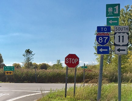
Heading the opposite direction, this was the first marker heading south from Canada: |
Mortell, 1996
|
|
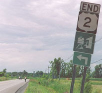
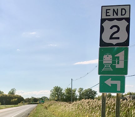
Not far ahead is the junction with US 2; these photos show signage posted at that intersection:
Mortell, 1996
|
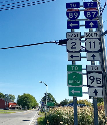
Bourey, Sep. 2019
US 2 begins to the left, and historically that junction marked the north beginning of US 11 (straight ahead).
|
Drivers who take that turn to the east immediately encounter the first confirming assembly for US 2[e]:
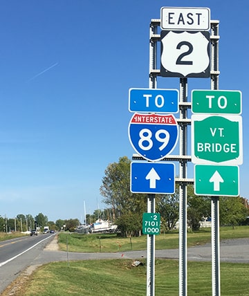
Bourey, Sep. 2019
|
Heading the opposite direction, as of 2019, the last westbound US 2 marker was four miles away, in Vermont, just past the junction with VT 225.
|
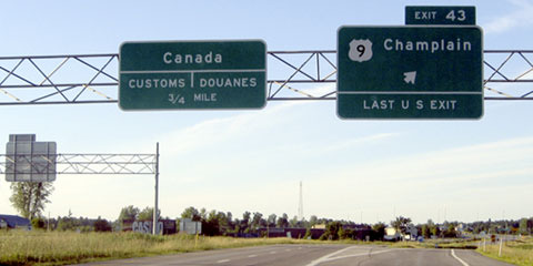
Now we need to turn our attention back to US 9 (which we left back in Champlain in 1947). US 9's original Champlain border station was torn down in 1967, right about the same time that I-87 was completed to the international boundary. Ever since then, US 9 no longer quite makes it to the Canada border. This photo shows the last northbound US 9 sign, heading north out of Champlain, with traffic on I-87 visible in the background:
|
Bourey, Sep. 2019
|
|
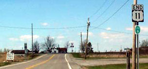
Just a bit further ahead, an "End" assembly is posted:
|
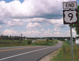
Field/Nitzman, July 2000
|
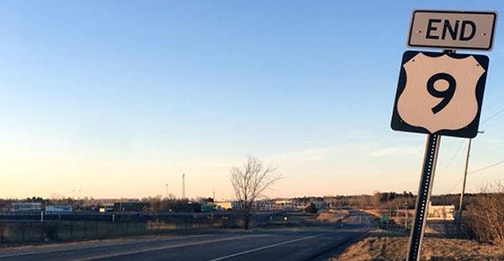
Bourey, Apr. 2018
|
|
The customs house is visible in the distance; to get there, one must enter I-87 (ahead to the left). I-87 bisects the original alignment of US 9, and that "End" sign happens to be right about where the original highway went slightly to the left, rather than along this newer frontage road, which dead-ends before reaching the border. This next shot was taken heading the same direction (northbound), but on I-87:
|
Nitzman, July 2005
|
|
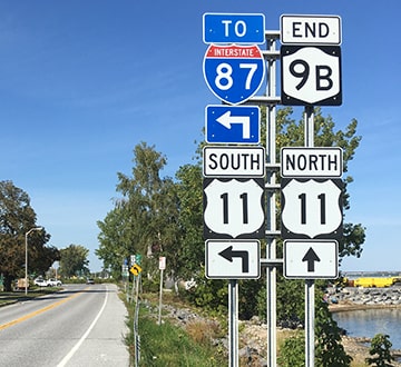
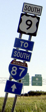
Drivers exiting there encounter this sign on the offramp:
Nitzman, July 2005
|
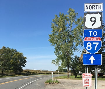
For drivers heading north on I-87, that is the north beginning of US 9; to the left leads only to a cul-de-sac adjacent to the customs house. These next photos show the first southbound signs:
Bourey, Apr. 2018
|
Nitzman, July 2005
|
|
In the background of that photo is the first exit sign for southbound I-87 coming from Canada; it is shown close-up here:
|
Nitzman, July 2005
|
Drivers exiting there are directed south on a service road, which soon passes underneath I-87 and connects to US 9, just south of the "End" sign shown previously.
Research and/or photo credits: George Bourey; Hank Eisenstein; Andy Field; Adam Froehlig; Dan Moraseski; Alex Nitzman; Chris Jordan; Robert Mortell; Mike Roberson; Dale Sanderson
Page originally created 2003;
last updated Jan. 21, 2023.
last updated Jan. 21, 2023.
