US Ends .com
  • Home
  • Store
    • US highway map
    • Florida US highway map
  • Endpoints
    • US 1 - US 9 >
      • 1 >
        • 201
        • 301
        • 401 [i]
        • 401 [ii]
        • 401
        • 501
        • 601
        • 701
      • 2w >
        • 102
      • 2e >
        • 202
        • 302
      • 3
      • 4 >
        • 104
      • 5
      • 6 >
        • 106
        • 206
      • 7
      • 8
      • 9 >
        • 109*
        • 209
        • 309
    • US 10 - US 19 >
      • 10 >
        • 110
        • 210
        • 310
        • 410
      • 11 >
        • 111
        • 211
        • 311
        • 411 [i]
        • 411 [ii]
        • 411
        • 511*
        • 611
        • 711*
      • 12 >
        • 112
        • 212
        • 312
      • 13 >
        • 113
        • 213
      • 14
      • 15
      • 16 >
        • 116
        • 216
      • 17 >
        • 17-1
        • 117 [i]
        • 117
        • 217
      • 18 >
        • 118
        • 218
      • 19 >
        • 119
        • 219
        • 319
    • US 20 - US 29 >
      • 20e >
        • 120
        • 220
        • 320
        • 420
      • 20w
      • 21 >
        • 121 [i]
        • 121
        • 221
        • 321
        • 421
        • 521
      • 22 >
        • 122 [i]
        • 122 [ii]
        • 222
        • 322
        • 422e
        • 422w
        • 522
        • 622*
      • 23 >
        • 123 [i]
        • 123
        • 223
      • 24 >
        • 124
        • 224
      • 25
      • 26 >
        • 126
      • 27 >
        • 127
        • 227
      • 28
      • 29 >
        • 129
    • US 30 - US 39 >
      • 30 >
        • 130
        • 230
        • 330
        • 430
        • 530
        • 630*
        • 730
        • 830
      • 31 >
        • 131
        • 231
        • 331 [i]
        • 331
        • 431
      • 32
      • 33
      • 34
      • 35
      • 36 >
        • 136
      • 38 >
        • 138
    • US 40 - US 49 >
      • 40 >
        • 140
        • 240
        • 340
      • 41 >
        • 141
        • 241 [i]
        • 241 [ii]
        • 341
        • 441 >
          • 441n
          • 441s
        • 541
        • 641
      • 42
      • 43
      • 44
      • 45
      • 46
      • 48 [i]
      • 48 [ii]
      • 48
      • 49
    • US 50 - US 59 >
      • 50 >
        • 150
        • 250
        • 350
        • 450
        • 550
        • 650
      • 51 - 55 >
        • 51 >
          • 151
        • 52 >
          • 152
        • 53
        • 54 >
          • 154
        • 55
      • 56 >
        • 156
      • 57
      • 58 >
        • 158
        • 258
      • 59 >
        • 159
        • 259
    • US 60 - US 69 >
      • 60 >
        • 160
        • 260
        • 360
        • 460
      • 61 - 65 >
        • 61 >
          • 161
        • 62
        • 63 >
          • 163 [i]
        • 64 >
          • 164 [i]
          • 164 [ii]
          • 264
        • 65 >
          • 165
      • 66 >
        • 166
        • 266
        • 366 [i]
        • 366 [ii]
        • 466
        • 566
        • 666
      • 67 >
        • 167
      • 68 >
        • 168
      • 69 >
        • 169
    • US 70 - US 79 >
      • 70 >
        • 170
        • 270 [i]*
        • 270
        • 370
        • 470
      • 71 >
        • 171
        • 271
        • 371 [i]
        • 371
      • 72 - 76 >
        • 72
        • 73
        • 74
        • 75 >
          • 175
          • 275
        • 76 >
          • 176
          • 276
      • 77 >
        • 177
        • 277
        • 377
      • 78 >
        • 178
        • 278
        • 378
      • 79
    • US 80 - US 89 >
      • 80 - 84 >
        • 80 >
          • 180 [i]
          • 180
          • 280
          • 380
        • 81 >
          • 181
          • 281
        • 82
        • 83 >
          • 183
          • 283
          • 383
        • 84
      • 85 - 89 >
        • 85 >
          • 185
          • 285 [i]
          • 285
          • 385 [i]
          • 385
          • 485
        • 87 >
          • 187
          • 287n
          • 287s
        • 89n
        • 89s >
          • 189 [i]
          • 189
    • US 90 - US 99 >
      • 90 - 94 >
        • 90 >
          • 190
          • 290
        • 91 >
          • 191 >
            • 191n
            • 191s
          • 491
        • 92 >
          • 192
        • 93
        • 94
      • 95 -98 >
        • 95 >
          • 195
          • 295
          • 395
        • 96 [i]
        • 96
        • 97 >
          • 197
        • 98
      • 99 >
        • 199
        • 299
        • 399
    • Anomalies >
      • 101
      • 163
      • 400
      • 412
      • 425
  • Places
    • A-L >
      • A >
        • Aberdeen
        • Albuquerque
        • Amarillo
        • Apalachicola
        • Astoria
        • Atlantic
      • B >
        • Baltimore
        • Baton Rouge
        • Bay Area
        • Bishop
        • Boone
        • Brady
        • Bristol
        • Brownsville
        • Brunswick
      • C >
        • Charleston
        • Chattanooga
        • Chicago
        • Cincinnati
        • Cleveland
        • Cody
        • Corpus
        • Cortez
        • Council Bluffs
        • Covington
        • Crescent
        • Cumberland Gap
      • D-E >
        • Dallas
        • Des Moines
        • Detroit
        • Dothan
        • Douglas
        • El Paso
        • Eugene
        • Erie
      • F >
        • Farmington
        • Flagstaff
        • Florence
        • Fox Valley
        • Franklin
      • G >
        • Gallup
        • Grand Junction
        • Grand Portage
        • Grayling
        • Great Falls
        • Greeley
      • H-I >
        • Hardeeville
        • Harrisburg
        • Holbrook
        • Idaho Falls
        • Int'l Falls
      • J-K >
        • Jacksonville
        • Joplin
        • Junction
        • Kansas City
        • Keokuk
        • Key West
        • Kingman
      • L >
        • Laredo
        • Lewiston
        • Long Beach
        • Los Angeles
        • Louisville
        • Lubbock
    • M-R >
      • M >
        • Mackinaw
        • Madison
        • Maryhill
        • Maysville
        • Miami
        • Midway
        • Miles City
        • Milford
        • Milwaukee
        • Minneapolis
        • Mobile 31
        • Mobile 31-43-45
        • Montgomery
        • Monticello
        • Mount Vernon
      • N-O >
        • Nags Head
        • Naples
        • Natchez
        • New Castle
        • New Orleans
        • Niagara
        • Norlina
        • Ocean City
        • Oklahoma City
      • P >
        • Pee Dee
        • Pembina
        • Pensacola
        • Petersburg
        • Philadelphia
        • Piegan
        • Pineville
        • Port Arthur
        • Portsmouth
      • Q-R >
        • Quad Cities
        • Rapid City
        • Raton
        • Reading
        • Richmond
        • Rockingham
        • Rouses Point
    • S-Z >
      • S >
        • San Antonio
        • San Antonio NM
        • San Diego
        • Santa Fe
        • Savannah
        • Sioux
        • Springer
        • Springfield
        • St. Ignace
        • St. John
        • St. Paul
        • St. Pete
      • T-U-V >
        • Tallahassee
        • Tampa
        • Toledo
        • Trinidad
        • Ucolo
        • VA Beach
      • W >
        • Walterboro
        • Waverly
        • West Memphis
        • Wilmington
        • Wilson
        • Wrightsville
      • Y >
        • Yellowstone E
        • Yellowstone N
        • Yellowstone NE
        • Yellowstone S
        • Yellowstone W
  • Highways
    • Map of all endpoints
    • Sources
    • History
    • 1926 almost-routes
    • Intra-state routes
    • Numbering
    • Colors
    • Gaps
    • Blog
  • Bonus
    • Colorado >
      • Lowest point
      • Antipodes
      • Toponymy >
        • Roots
      • Colloquialisms
      • Populations
      • Denvers
    • Washington Meridian
    • Watersheds >
      • Headwaters Hill
      • Three Waters Mtn.
      • Parting of the Waters
    • Geo-centers >
      • 48 states
      • 50 states
      • North America
    • State corners >
      • AZ-CO-NM-UT
      • CO-UT-WY
      • CO-NE-WY
      • CO northeast
      • CO-KS-NE
      • CO-KS-OK
      • CO-NM-OK
      • NM-OK-TX
      • NM southeast
      • TX northwest
    • ooss.space
  • Connect
    • Author/history
    • Rationale
    • Contact
    • Contributors
    • Submissions

End of US highway 425

View a map showing this route.
Get your very own map showing all current and historic US routes!
1989-2005
  • North: Pine Bluff, AR
  • South: Bastrop, LA
2005-present
  • North: Pine Bluff, AR
  • South: Natchez, MS
As of 2020, US 425 measured 215.4 miles in total length.

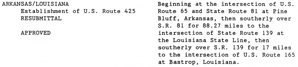
US 425 is one of three relatively-new US highways which commit serious breaches in an otherwise fairly logical numbering system.  Based on this system, US 425 should connect with US 25.  But it does not even come close.  When it was first commissioned, US 425 connected with US 65 on the north, and US 165 on the south... so the obvious solution would have been to number it US x65.  ​But here is the verbiage of the proposal that AASHTO approved in Oct. 1989:
Picture
Then in 2005, AASHTO approved an extension of US 425 which went down to US 65 at Clayton LA.  It was irksome enough that an illegitimate number got extended, but that was not the worst of it: the US 65 designation got truncated at Clayton, and US 425 replaced it from there to Natchez.  So now we have a nearly-1000-mile route (US 65) that has been around since the beginning (1926), terminating at a 200-mile branch route (US 425) that has been around only since 1989.  Sadly, it would seem that most state DoTs have no knowledge of the design behind (or respect for the integrity of) the US route system.  And even worse, the supposed guardian of this system (AASHTO's Special Committee on Route Numbering) doesn't either.  Instead, they usually just rubber-stamp any proposal that the states put before them.

There is a fix: US 425 is the shortest route between Natchez and Pine Bluff, and therefore the Arkansas and Louisiana DoTs consider it the primary route between their capital cities (Little Rock and Baton Rouge).  So US 65 should be changed to run southward out of Pine Bluff (along the current US 425) all the way to Natchez.  The existing US 65 between Pine Bluff and Clayton could be renumbered US 265.  That way, the primary highway would be signed with a "main" number (US 65); a "branch" number (265) would be applied to the secondary route; and we would be rid of the nonsensical number "425" (more on the anomalies page).
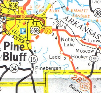
As it stands currently, the north end of US 425 is at Pine Bluff.  Heading north, there is no "End" sign, but there are no more US 425 signs beyond the junction with US 65.  In other words, signage heading northbound at this junction still reflects the original north end of US 425:
Picture
c. 1994, AHTD
This first photo was taken looking north on US 425 at that intersection.  ​The crossing highway is US 65; Pine Bluff is to the left (west):
Picture
Backlin, Oct. 2007
In 2002, when the I-530 bypass was completed, the US 425 designation was extended west with northbound US 65, such that it now ends at its junction with I-530.  However, travelers at the US 65 junction can easily assume that US 425 still ends there, because there are no more 425 signs.  When a driver makes that turn to the west, only US 65 is marked...
Picture
Backlin, Oct. 2007
...but technically that is also northbound US 425.  That designation ends where the I-530 designation begins:
Picture
Backlin, Oct. 2007
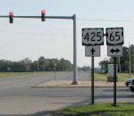
Incidentally, US 65 traffic is supposed to follow I-530, but Arkansas is one of a growing number of states that do not co-sign US routes where they overlap with interstates.  Heading the opposite direction (southbound on I-530), US 425 is well-signed:
Picture
Backlin, Oct. 2007
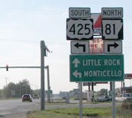
​Up ahead, after I-530 has ended, the first confirming assembly looks like this...
Picture
Backlin, Oct. 2007
...and this photo shows signage at the junction where US 65 and US 425 split:
Picture
Backlin, Oct. 2007
​But heading the opposite direction (west on northbound US 65), US 425 is shown running only to the south...
Picture
Backlin, Oct. 2007
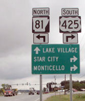
...and it is the same way at the south end of AR 81:
Picture
Backlin, Oct. 2007
​So, with regard to actual signage, it could be said that US 425 ends at one junction, but begins at another.

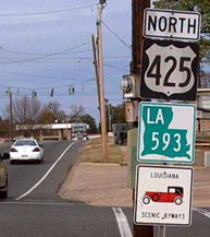
​Originally the south end of US 425 was at US 165 in Bastrop:
Picture
c. 2005, LADoTD
Both routes are split into one-way pairs through the central part of town. The photo below is looking east on Jefferson Avenue, which carries northbound US 165:
Picture
Nelson, Jan. 2006
The south beginning of US 425 was to the left on Franklin Street.  If a driver turned that direction, they would soon see the first northbound confirming assembly:
Picture
Nelson, Jan. 2006
​Southbound US 165 runs westward through town on Madison Avenue (one block to the north of Jefferson).  The beginning of US 425 as seen from that direction was posted thus: 
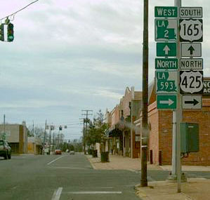
Picture
Nelson, Jan. 2006
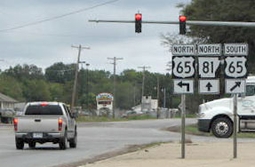
The next block ahead is Washington Street, which carries southbound US 425.  In 2005 the route was extended to Natchez.

Research and/or photo credits: David Backlin; Steven Nelson; Dale Sanderson
Page originally created 1999;
last updated July 2, 2020.

Copyright © 1998-2023
Picture