US Ends .com
  • Home
  • Store
    • US highway book
    • US highway map
    • Florida US highway map
  • Endpoints
    • US 1 - US 9 >
      • 1 >
        • 201
        • 301
        • 401 [i]
        • 401 [ii]
        • 401
        • 501
        • 601
        • 701
      • 2w >
        • 102
      • 2e >
        • 202
        • 302
      • 3
      • 4 >
        • 104
      • 5
      • 6 >
        • 106
        • 206
      • 7
      • 8
      • 9 >
        • 109*
        • 209
        • 309
    • US 10 - US 19 >
      • 10 >
        • 110
        • 210
        • 310
        • 410
      • 11 >
        • 111
        • 211
        • 311
        • 411 [i]
        • 411 [ii]
        • 411
        • 511*
        • 611
        • 711*
      • 12 >
        • 112
        • 212
        • 312
      • 13 >
        • 113
        • 213
      • 14
      • 15
      • 16 >
        • 116
        • 216
      • 17 >
        • 17-1
        • 117 [i]
        • 117
        • 217
      • 18 >
        • 118
        • 218
      • 19 >
        • 119
        • 219
        • 319
    • US 20 - US 29 >
      • 20e >
        • 120
        • 220
        • 320
        • 420
      • 20w
      • 21 >
        • 121 [i]
        • 121
        • 221
        • 321
        • 421
        • 521
      • 22 >
        • 122 [i]
        • 122 [ii]
        • 222
        • 322
        • 422e
        • 422w
        • 522
        • 622*
      • 23 >
        • 123 [i]
        • 123
        • 223
      • 24 >
        • 124
        • 224
      • 25
      • 26 >
        • 126
      • 27 >
        • 127
        • 227
      • 28
      • 29 >
        • 129
    • US 30 - US 39 >
      • 30 >
        • 130
        • 230
        • 330
        • 430
        • 530
        • 630*
        • 730
        • 830
      • 31 >
        • 131
        • 231
        • 331 [i]
        • 331
        • 431
      • 32
      • 33
      • 34
      • 35
      • 36 >
        • 136
      • 38 >
        • 138
    • US 40 - US 49 >
      • 40 >
        • 140
        • 240
        • 340
      • 41 >
        • 141
        • 241 [i]
        • 241 [ii]
        • 341
        • 441 >
          • 441n
          • 441s
        • 541
        • 641
      • 42
      • 43
      • 44
      • 45
      • 46
      • 48 [i]
      • 48 [ii]
      • 48
      • 49
    • US 50 - US 59 >
      • 50 >
        • 150
        • 250
        • 350
        • 450
        • 550
        • 650
      • 51 - 55 >
        • 51 >
          • 151
        • 52 >
          • 152
        • 53
        • 54 >
          • 154
        • 55
      • 56 >
        • 156
      • 57
      • 58 >
        • 158
        • 258
      • 59 >
        • 159
        • 259
    • US 60 - US 69 >
      • 60 >
        • 160
        • 260
        • 360
        • 460
      • 61 - 65 >
        • 61 >
          • 161
        • 62
        • 63 >
          • 163 [i]
        • 64 >
          • 164 [i]
          • 164 [ii]
          • 264
        • 65 >
          • 165
      • 66 >
        • 166
        • 266
        • 366 [i]
        • 366 [ii]
        • 466 [i]*
        • 466 [ii]
        • 566
        • 666
      • 67 >
        • 167
      • 68 >
        • 168
      • 69 >
        • 169
    • US 70 - US 79 >
      • 70 >
        • 170
        • 270 [i]*
        • 270
        • 370
        • 470
      • 71 >
        • 171
        • 271
        • 371 [i]
        • 371 [ii]
        • 371
      • 72 - 76 >
        • 72
        • 73
        • 74
        • 75 >
          • 175
          • 275
        • 76 >
          • 176
          • 276
      • 77 >
        • 177
        • 277
        • 377
      • 78 >
        • 178
        • 278
        • 378
      • 79
    • US 80 - US 89 >
      • 80 - 84 >
        • 80 >
          • 180 [i]
          • 180
          • 280
          • 380
        • 81 >
          • 181
          • 281
        • 82
        • 83 >
          • 183
          • 283
          • 383
        • 84
      • 85 - 89 >
        • 85 >
          • 185
          • 285 [i]
          • 285
          • 385 [i]
          • 385
          • 485
        • 87 >
          • 187
          • 287n
          • 287s
        • 89n
        • 89s >
          • 189 [i]
          • 189
    • US 90 - US 99 >
      • 90 - 94 >
        • 90 >
          • 190
          • 290
        • 91 >
          • 191 >
            • 191n
            • 191s
          • 491
        • 92 >
          • 192
        • 93
        • 94
      • 95 -98 >
        • 95 >
          • 195
          • 295
          • 395
        • 96 [i]
        • 96
        • 97 >
          • 197
        • 98
      • 99 >
        • 199
        • 299
        • 399
    • Anomalies >
      • 101
      • 163
      • 400
      • 412
      • 425
  • Places
    • A-L >
      • A >
        • Aberdeen
        • Albuquerque
        • Amarillo
        • Apalachicola
        • Astoria
        • Atlantic
      • B >
        • Baltimore
        • Baton Rouge
        • Bay Area
        • Bishop
        • Boone
        • Brady
        • Bristol
        • Brownsville
        • Brunswick
      • C >
        • Charleston
        • Chattanooga
        • Chicago
        • Cincinnati
        • Cleveland
        • Cody
        • Corpus
        • Cortez
        • Council Bluffs
        • Covington
        • Crescent
        • Cumberland Gap
      • D-E >
        • Dallas
        • Des Moines
        • Detroit
        • Dothan
        • Douglas
        • El Paso
        • Erie
        • Eugene
      • F >
        • Farmington
        • Flagstaff
        • Florence
        • Fox Valley
        • Franklin
      • G >
        • Gallup
        • Georgetown
        • Grand Junction
        • Grand Portage
        • Grayling
        • Great Falls
        • Greeley
      • H-I >
        • Hardeeville
        • Harrisburg
        • Holbrook
        • Idaho Falls
        • Int'l Falls
      • J-K >
        • Jacksonville
        • Joplin
        • Junction
        • Kansas City
        • Keokuk
        • Key West
        • Kingman
      • L >
        • Laredo
        • Lewiston
        • Long Beach
        • Los Angeles
        • Louisville
        • Lubbock
    • M-R >
      • M >
        • Mackinaw
        • Madison
        • Maryhill
        • Maysville
        • Miami
        • Midway
        • Miles City
        • Milford
        • Milwaukee
        • Minneapolis
        • Mobile 31
        • Mobile 31-43-45
        • Montgomery
        • Monticello
        • Mount Vernon
      • N-O >
        • Nags Head
        • Naples
        • Natchez
        • New Castle
        • New Orleans
        • Niagara
        • Norlina
        • Ocean City
        • Oklahoma City
      • P >
        • Pee Dee
        • Pembina
        • Pensacola
        • Petersburg
        • Philadelphia
        • Piegan
        • Pineville
        • Port Arthur
        • Portsmouth
      • Q-R >
        • Quad Cities
        • Rapid City
        • Raton
        • Reading
        • Richmond
        • Rockingham
        • Rouses Point
    • S-Z >
      • S >
        • San Antonio
        • San Antonio NM
        • San Diego
        • Santa Fe
        • Savannah
        • Sioux
        • Springer
        • Springfield
        • St. Ignace
        • St. John
        • St. Paul
        • St. Pete
      • T-U-V >
        • Tallahassee
        • Tampa
        • Toledo
        • Trinidad
        • Tuba City
        • Ucolo
        • VA Beach
      • W >
        • Walterboro
        • Waverly
        • West Memphis
        • Wilmington
        • Wilson
        • Wrightsville
      • Y >
        • Yellowstone E
        • Yellowstone N
        • Yellowstone NE
        • Yellowstone S
        • Yellowstone W
  • Highways
    • Map of all endpoints
    • Sources
    • History
    • 1926 almost-routes
    • Intra-state routes
    • Numbering
    • Colors
    • Gaps
    • Blog
  • Bonus
    • Colorado >
      • Lowest point
      • Antipodes
      • Toponymy >
        • Roots
      • Colloquialisms
      • Populations
      • Denvers
    • Washington Meridian
    • Watersheds >
      • Headwaters Hill
      • Three Waters Mtn.
      • Parting of the Waters
    • Geo-centers >
      • 48 states
      • 50 states
      • North America
    • State corners >
      • AZ-CO-NM-UT
      • CO-UT-WY
      • CO-NE-WY
      • CO northeast
      • CO-KS-NE
      • CO-KS-OK
      • CO-NM-OK
      • NM-OK-TX
      • NM southeast
      • TX northwest
  • Connect
    • Author/history
    • Rationale
    • Contact
    • Contributors
    • Submissions

End of US highway 63

View a map showing this route.
Get your very own map showing all current and historic US routes!
Picture
Summa
Picture
Summa
1926-1934
  • North: Des Moines, IA
  • South: Turrell, AR
1934-1940
  • North: Ashland, WI
  • South: Turrell, AR
1940-1999
  • North: near Ashland, WI
  • South: West Memphis, AR *
1999-present
  • North: near Ashland, WI
  • South: Ruston, LA
*During these years, Memphis TN was the south end of US 63 according to AASHTO.  However, I have not seen any evidence suggesting that US 63 was ever signposted anywhere in Tennessee.
Get your copy of this epic book that commemorates the first century of the US route system!

Mileage: in 1989 AASHTO listed a figure of 1036 miles for US 63... however, that included the mileage of US 63's associated business routes.  According to the state subtotals on AASHTO's 1989 spreadsheet, mainline US 63's actual end-to-end total at the time was 1001 miles.  However, US 63 ended in the Memphis area at the time; since then it has been extended to Ruston, and our own 2020 measurement yielded 1279.8 miles.  Want historic mileages?  Our handy reference book includes the mileages that were published in all 13 of AASHO/AASHTO's historic route logs (spanning the years 1927 to 1989).
US 63 was an original 1926 route, but it ran only from US 61 at Turrell to Des Moines (north from Oskaloosa, US 63 essentially followed what is now IA 163).  Photos and info about all of US 63's historic south endpoints in Arkansas are available on the West Memphis page. 

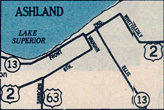
In 1934, the US 63 designation was truncated at Oskaloosa IA, and traffic was instead directed north along its current route: through Waterloo, Rochester MN, and northwest Wisconsin.  Originally US 63 was signed along the roads that are now designated WI hwys. 112 and 118, ending right in downtown Ashland:
Picture
c. 1935, Wisconsin DoT
It came north via Sanborn Avenue, and then went east with US 2 along 6th Street; the US 63 designation ended at the junction with WI 13 on Vaughn Avenue at 2nd Street.  Here is a vintage photo showing the classic gas station that was formerly on that corner: 
Picture
(date and attribution unknown)
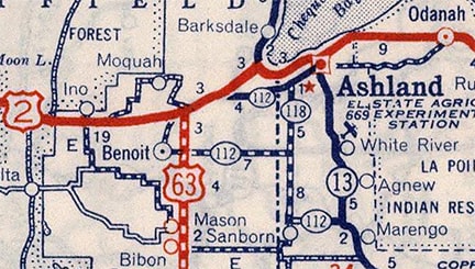
​In 1939, US 63 was truncated near Benoit, and instead redirected due north to the junction with US 2, about ten miles west of Ashland...
Picture
c. 1939, Rand McNally
Picture
c. 1940, Rand McNally
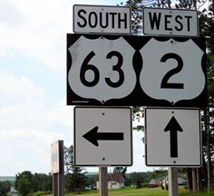
...however, US 63 was not immediately truncated to its junction with US 2.  Rather, for the next 50 years it was dual-signed with US 2 to its historic endpoint in Ashland.  At some point (possibly in the 1950s) US 2 was removed from Main Street (nee 2nd St) and instead followed Lake Shore Drive (nee Front St) all the way through town (its current routing).  At that time, US 63's terminus would have moved one block to the northwest, such that it ended on Lake Shore at Vaughn.  And when Wisconsin highway 13 moved to Ellis Avenue, US 63 may have been extended along Lake Shore to Ellis.  1990 was the year that the overlap with US 2 was eliminated, and US 63 was shortened to its current terminus:
Picture
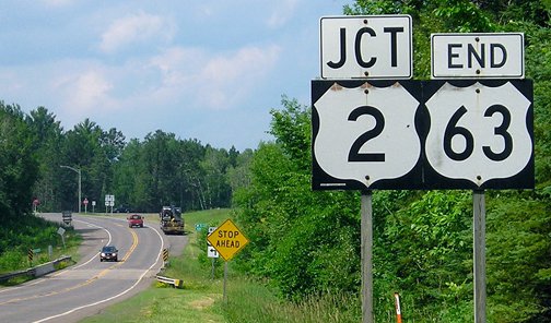
Morrison, July 2013 (unchanged since at least 2000)
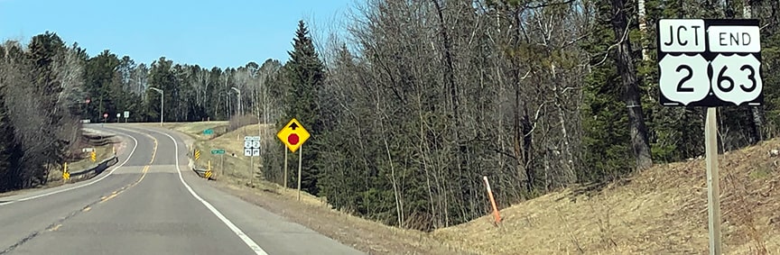
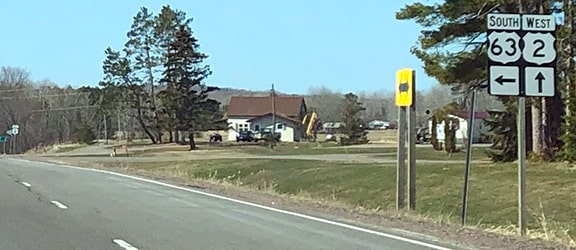
Picture
Johnson, Apr. 2020
These photos show signage ahead at the actual junction; Ashland is to the east (right), while to the west lie the twin ports of Superior WI and Duluth MN:
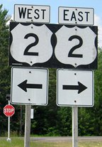
Picture
Morrison, July 2013
Picture
Johnson, Apr. 2020
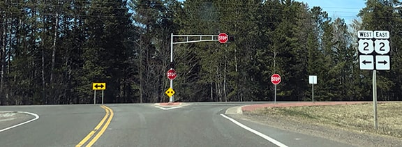
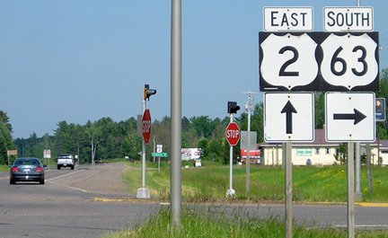
​These next photos show the north beginning of US 63 as seen from westbound and eastbound US 2, respectively:
Picture
Morrison, July 2013
Picture
Johnson, Apr. 2020
Picture
Morrison, July 2013 (unchanged since at least 2006)
Drivers turning onto US 63 will soon see the first southbound marker:
Picture
Morrison, July 2013

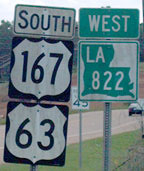
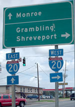
​In 1999, the US 63 designation was extended south (by taking a sharp turn at West Memphis and heading in an entirely different direction) to a new endpoint in Ruston.  To many highway enthusiasts, this seemed like an unnecessary and ill-advised move (commentary and photos on Jeff Morrison's page).  This photo shows one of the last US 63 signs heading south:
Picture
Bumgardner, June 2007
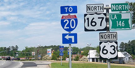
​The junction with I-20 is now the endpoint of US 63:
Picture
Bumgardner, June 2007
​Heading back the other way, the first northbound US 63 sign is also at that interchange: 
Picture
Karners, Apr. 2014 (unchanged since 2007)
​As of 2023, US 63 is still not mentioned on the exit signage from I-20.
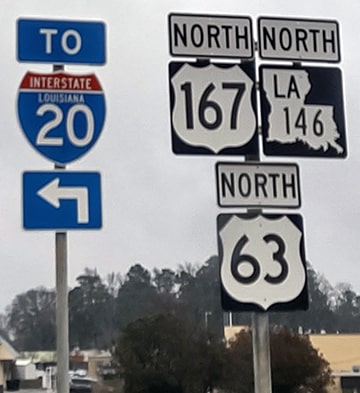
Picture
Turner, Feb. 2023

Research and/or photo credits: Chris Bessert; Josh Bumgardner; Peter Johnson; Karin and Martin Karner; Jeff Morrison; Dale Sanderson; Michael Summa; Charles Turner
Page originally created 2000;
last updated Dec. 17, 2023.
Copyright © 1998-2025
Picture