End of US highway 17 |
 |
Summa
|
Summa
|
|
1926-1931
|
1931-1964
|
1964-present
|
|
Mileage: in 1989 AASHTO listed a figure of 1429 miles for US 17... however, that included the mileage of US 17's associated business/bypass/alternate routes. According to the state subtotals on AASHTO's 1989 spreadsheet, mainline US 17's actual end-to-end total at the time was 1189 miles. That is reasonably close to our own 2020 measurement, which yielded 1205.4 miles (reroutings and realignments likely explain the difference).
|
|
|
US 17 was among the original 1926 routes; its original south end was in Jacksonville. Historically the north terminus was in Fredericksburg:
|
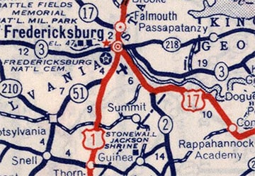
c. 1939, Rand McNally
|
|
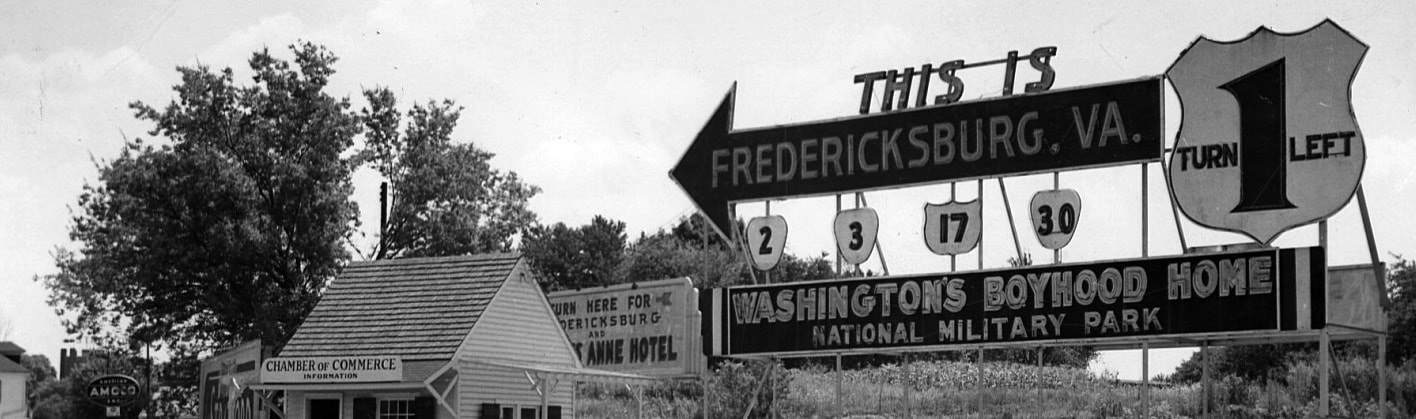
US 1 came into town from the north via Princess Anne Street, and then continued south by turning west on Lafayette Boulevard. US 17 came in from the south on Dixon Street, so it could have ended south of downtown, at its junction with US 1 (Princess Anne and Lafayette). However, there is photo evidence (not clear enough to post here) suggesting that US 17 was actually overlapped north with US 1 past the courthouse, ending at the junction with VA highway 3. At the time, VA 3 ran along William Street, and in the early days it was common for highways to be overlapped into central business districts. This interactive image is looking north on Princess Anne at William:
|
|
It seems likely that was the original endpoint of US 17. In about 1945, the Fredericksburg bypass was built (Jefferson Davis Highway), but for about 25 years that was designated Alternate US 1 (and, as we'll see below, it is still erroneously signed that way on southbound US 1). Meanwhile, mainline US 1 traffic continued to follow the original routing through downtown. So it is unclear whether US 17 was extended north on Princess Anne (along with US 1) to the bypass, or whether it continued to end downtown. But we do have this photo:
date and attribution unknown
That was looking south on US 1, just past the Rappahannock River bridge. Straight ahead was the bypass (Alt. US 1), but mainline US 1 turned left on Princess Anne. Note that US 17 traffic was also noted on that sign. Obviously it was not a VDoT sign, so we cannot assume it was technically accurate. And it should be noted that neither VA 3 nor VA 30 actually ran along the segment of Princess Anne to the left. Rather, the sign was communicating that travelers could reach those routes by turning left. So did US 17 actually begin to the left? Or was the sign to be interpreted as "TO US 17"?
|
Until more information is found, the answer is unknown... although there are a couple reasons why it would have made sense to extend US 17 to the bypass. This would have ensured that all US 1 traffic (mainline and bypass) had a connection to US 17. And it would have brought US 17 traffic closer to VA 17 (which began right across the river in Falmouth). Here is a more recent view from the same perspective:
|

Elbert, July 2006
|
|
At one time, the north beginning of US 17 may have been to the left. The backside of those signs are visible in this next photo, which was looking north on Princess Anne. This may have been the north terminus of US 17 prior to 1964:
|
Elbert, July 2006
|
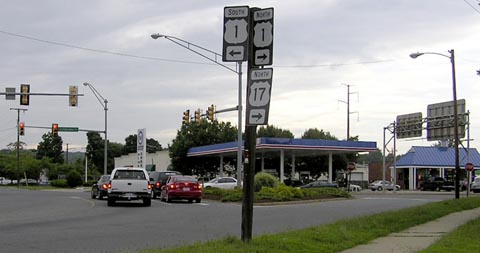
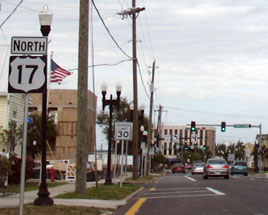
In 1931 the south end of US 17 was extended to Punta Gorda. In town today, both US 17 and US 41 are separated onto one-way pairs, but originally both directions of US 17 used Marion Avenue, and both directions of US 41 used the road originally known as King Street (but modern street signs simply label it "US 41 NB"). So the original Punta Gorda terminus of US 17 was on Marion at King.
|
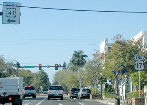
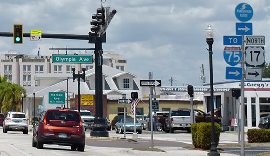
In 1976 a separate bridge over the Peace River was opened for southbound US 41 traffic. This bridge aligns with Cross Street, so at that time US 17 was extended about four blocks further south to its current terminus on Marion at Cross. Approach signage on Marion (southbound US 17) looks like this:
|
Cozart, Dec. 2003 (unchanged as of Apr. 2022)
|
|
As with many assemblies around this junction, there was an identical one on the opposite side of the road. Next is a close-up of the overhead signage (both historic and current, which is visible in the distance of the photo above):

Nasiatka, Jan. 2003
|
Ivy, Apr. 2022
|
|
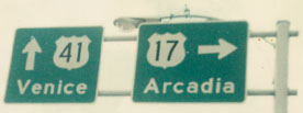
US 41, aka Tamiami Trail, is also split into a one-way pair here. About four blocks ahead is the left turn to southbound US 41. Historically there was an "End" sign just before one reached that intersection...
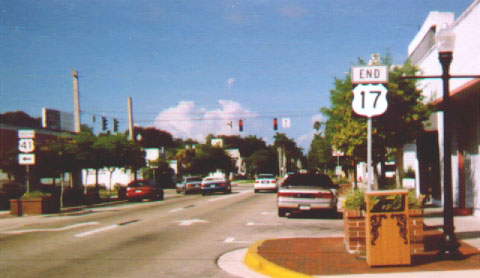
Droz, 2000
|
...but that had changed within a few years. First, the US 41 sign was reconfigured as an overhead...
Cozart, Dec. 2003
|
|
...and by June 2005, that "End" signpost had apparently become a casualty of Hurricane Charley. In its place was a redundant "South US 41 left turn" sign, as shown here:
|
Ivy, Apr. 2022
|
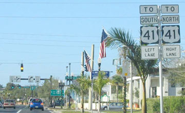
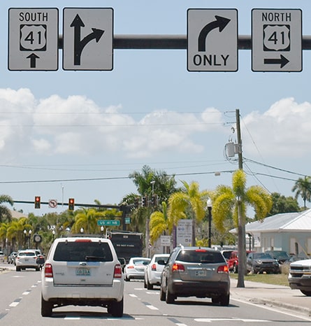
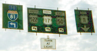
If a driver were to turn left from there onto southbound US 41, they would see this overhead and approach signage to the beginning of US 17:
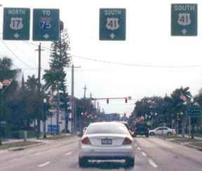
Nasiatka
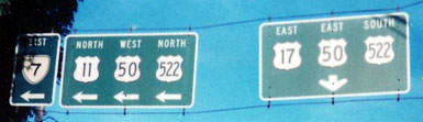
|
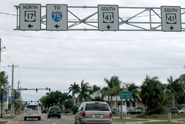
Nitzman, Mar. 2007 (unchanged as of 2022)
|
Nitzman, Mar. 2007 (unchanged as of 2022)
|
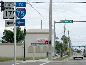
The south beginning of US 17 is to the left on Olympia Avenue. If a traveler were to make another left turn there, they would soon see the first northbound US 17 confirmation signs (one on each side of the road):
Nitzman, Mar. 2007 (unchanged as of 2022)
|
Ivy, Apr. 2022
|
|
That was looking northeast on Olympia; southbound US 41 is just behind the camera, and northbound is a few blocks ahead. Marion (southbound US 17) is one block to the left. Here is current and historic signage from northbound US 41:
|
Summa, 1975
|

Cozart, Dec. 2003
|
Ivy, Apr. 2022
|
|
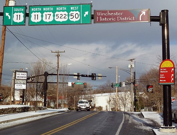
In 1964 US 17 was extended northward (along the former VA 17) to Winchester. There US 11, US 50, and US 522 all converge in the downtown area. At the time (and right up until 2010), all routes were directed onto a one-way pair consisting of Braddock Street (southbound) and Cameron Street (northbound). This shot was looking south on Braddock, approaching the intersection with Gerrard Street, where the routes begin to diverge. This was the first reference to US 17:
|
Prince, 2000
|
|
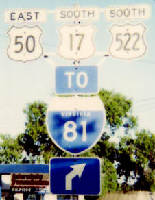
The sign on the right indicated that US 11 continued straight on Braddock, which immediately turns into Valley Avenue and heads toward Harrisonburg. (US 11 was the original highway serving the Shenandoah Valley, before I-81 was built.) The middle sign directs US 17, US 50, and US 522 traffic to the left, onto Gerrard. Signage heading east on Gerrard once looked like this:
|
Summa, 1995
|
|
At Gerrard and Cameron, there is a five-point intersection with Millwood Avenue, onto which all three routes are directed.
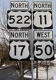
This was also looking east on Gerrard. Note the angled arrow -- that is because of the angle at which Millwood comes in from the southeast. (That I-81 shield was replaced by 2000, and the entire assembly is gone now. In fact, as of 2000 all references to US 17 on the mainline had been removed between here and I-81. US 522 splits off just past the I-81 interchange, while US 17 and US 50 are overlapped for another 20 miles or so, to Paris.) |
Summa, 1995
|
|
Now that reference to I-81 appears instead on the replacement overhead sign. Another way in which the information on that sign has changed is that US 17 is now shown to head north (in addition to south):

Karners, Jan. 2017
|
Based on those older signs, one could conclude that historically the north beginning of US 17 was at the intersection of Braddock and Gerrard, and the north end was formerly at the aforementioned five-way (Gerrard/Cameron/Millwood). This image was taken looking north on Millwood at the old north end of US 17...
Karners, Jan. 2017
|
|
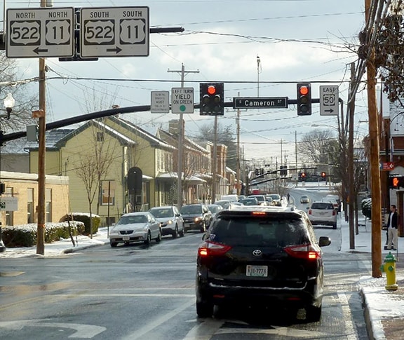
...and there is no reason why US 17 could not still end there, but signage clearly shows that the designation extends further north now. That change took place in 2010, when Cameron and Braddock were both changed back to two-way streets, and some of the highway designations downtown were changed as well. Today all four routes angle to the right on Cameron, and there the last northbound US 17 marker is posted:
|
Karners, Jan. 2017
|
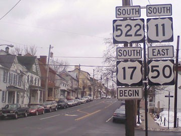
Now westbound US 50 traffic is directed to turn west on Cork Street (instead of Picadilly), and approaching that intersection an "End" assembly is posted for US 17:

Pannunzio, Mar. 2010 (unchanged as of 2020)
|
|
Heading east on US 50 (Cork), traffic is directed to turn south on Cameron, and signs are posted for US 11 and US 522 as well. However, there was no reference to US 17...
Karners, Jan. 2017
|
...but drivers taking that right turn will immediately encounter a "Begin" assembly for US 17:
Pannunzio, Mar. 2010 (unchanged as of 2020)
That is positioned directly across the road from the "End" sign shown above. So it would seem the US 17 designation has been extended north on Cameron, ending at Cork. Why that particular intersection is unclear, other than that junction marks a turn for US 50 traffic.
|
Research and/or photo credits: Robert Brooks; Justin Cozart; Robert Droz; Chris Elbert; Brent Ivy; Karin and Martin Karner; J.P. Nasiatka; Alex Nitzman; Charles Pannunzio; Adam Prince; Michael Roberson; Dale Sanderson; Michael Summa
Page originally created 2000;
last updated Dec. 15, 2023.
last updated Dec. 15, 2023.
