US Ends .com
  • Home
  • Store
    • US highway map
    • Florida US highway map
  • Endpoints
    • US 1 - US 9 >
      • 1 >
        • 201
        • 301
        • 401 [i]
        • 401 [ii]
        • 401
        • 501
        • 601
        • 701
      • 2w >
        • 102
      • 2e >
        • 202
        • 302
      • 3
      • 4 >
        • 104
      • 5
      • 6 >
        • 106
        • 206
      • 7
      • 8
      • 9 >
        • 109*
        • 209
        • 309
    • US 10 - US 19 >
      • 10 >
        • 110
        • 210
        • 310
        • 410
      • 11 >
        • 111
        • 211
        • 311
        • 411 [i]
        • 411 [ii]
        • 411
        • 511*
        • 611
        • 711*
      • 12 >
        • 112
        • 212
        • 312
      • 13 >
        • 113
        • 213
      • 14
      • 15
      • 16 >
        • 116
        • 216
      • 17 >
        • 17-1
        • 117 [i]
        • 117
        • 217
      • 18 >
        • 118
        • 218
      • 19 >
        • 119
        • 219
        • 319
    • US 20 - US 29 >
      • 20e >
        • 120
        • 220
        • 320
        • 420
      • 20w
      • 21 >
        • 121 [i]
        • 121
        • 221
        • 321
        • 421
        • 521
      • 22 >
        • 122 [i]
        • 122 [ii]
        • 222
        • 322
        • 422e
        • 422w
        • 522
        • 622*
      • 23 >
        • 123 [i]
        • 123
        • 223
      • 24 >
        • 124
        • 224
      • 25
      • 26 >
        • 126
      • 27 >
        • 127
        • 227
      • 28
      • 29 >
        • 129
    • US 30 - US 39 >
      • 30 >
        • 130
        • 230
        • 330
        • 430
        • 530
        • 630*
        • 730
        • 830
      • 31 >
        • 131
        • 231
        • 331 [i]
        • 331
        • 431
      • 32
      • 33
      • 34
      • 35
      • 36 >
        • 136
      • 38 >
        • 138
    • US 40 - US 49 >
      • 40 >
        • 140
        • 240
        • 340
      • 41 >
        • 141
        • 241 [i]
        • 241 [ii]
        • 341
        • 441 >
          • 441n
          • 441s
        • 541
        • 641
      • 42
      • 43
      • 44
      • 45
      • 46
      • 48 [i]
      • 48 [ii]
      • 48
      • 49
    • US 50 - US 59 >
      • 50 >
        • 150
        • 250
        • 350
        • 450
        • 550
        • 650
      • 51 - 55 >
        • 51 >
          • 151
        • 52 >
          • 152
        • 53
        • 54 >
          • 154
        • 55
      • 56 >
        • 156
      • 57
      • 58 >
        • 158
        • 258
      • 59 >
        • 159
        • 259
    • US 60 - US 69 >
      • 60 >
        • 160
        • 260
        • 360
        • 460
      • 61 - 65 >
        • 61 >
          • 161
        • 62
        • 63 >
          • 163 [i]
        • 64 >
          • 164 [i]
          • 164 [ii]
          • 264
        • 65 >
          • 165
      • 66 >
        • 166
        • 266
        • 366 [i]
        • 366 [ii]
        • 466
        • 566
        • 666
      • 67 >
        • 167
      • 68 >
        • 168
      • 69 >
        • 169
    • US 70 - US 79 >
      • 70 >
        • 170
        • 270 [i]*
        • 270
        • 370
        • 470
      • 71 >
        • 171
        • 271
        • 371 [i]
        • 371
      • 72 - 76 >
        • 72
        • 73
        • 74
        • 75 >
          • 175
          • 275
        • 76 >
          • 176
          • 276
      • 77 >
        • 177
        • 277
        • 377
      • 78 >
        • 178
        • 278
        • 378
      • 79
    • US 80 - US 89 >
      • 80 - 84 >
        • 80 >
          • 180 [i]
          • 180
          • 280
          • 380
        • 81 >
          • 181
          • 281
        • 82
        • 83 >
          • 183
          • 283
          • 383
        • 84
      • 85 - 89 >
        • 85 >
          • 185
          • 285 [i]
          • 285
          • 385 [i]
          • 385
          • 485
        • 87 >
          • 187
          • 287n
          • 287s
        • 89n
        • 89s >
          • 189 [i]
          • 189
    • US 90 - US 99 >
      • 90 - 94 >
        • 90 >
          • 190
          • 290
        • 91 >
          • 191 >
            • 191n
            • 191s
          • 491
        • 92 >
          • 192
        • 93
        • 94
      • 95 -98 >
        • 95 >
          • 195
          • 295
          • 395
        • 96 [i]
        • 96
        • 97 >
          • 197
        • 98
      • 99 >
        • 199
        • 299
        • 399
    • Anomalies >
      • 101
      • 163
      • 400
      • 412
      • 425
  • Places
    • A-L >
      • A >
        • Aberdeen
        • Albuquerque
        • Amarillo
        • Apalachicola
        • Astoria
        • Atlantic
      • B >
        • Baltimore
        • Baton Rouge
        • Bay Area
        • Bishop
        • Boone
        • Brady
        • Bristol
        • Brownsville
        • Brunswick
      • C >
        • Charleston
        • Chattanooga
        • Chicago
        • Cincinnati
        • Cleveland
        • Cody
        • Corpus
        • Cortez
        • Council Bluffs
        • Covington
        • Crescent
        • Cumberland Gap
      • D-E >
        • Dallas
        • Des Moines
        • Detroit
        • Dothan
        • Douglas
        • El Paso
        • Eugene
        • Erie
      • F >
        • Farmington
        • Flagstaff
        • Florence
        • Fox Valley
        • Franklin
      • G >
        • Gallup
        • Grand Junction
        • Grand Portage
        • Grayling
        • Great Falls
        • Greeley
      • H-I >
        • Hardeeville
        • Harrisburg
        • Holbrook
        • Idaho Falls
        • Int'l Falls
      • J-K >
        • Jacksonville
        • Joplin
        • Junction
        • Kansas City
        • Keokuk
        • Key West
        • Kingman
      • L >
        • Laredo
        • Lewiston
        • Long Beach
        • Los Angeles
        • Louisville
        • Lubbock
    • M-R >
      • M >
        • Mackinaw
        • Madison
        • Maryhill
        • Maysville
        • Miami
        • Midway
        • Miles City
        • Milford
        • Milwaukee
        • Minneapolis
        • Mobile 31
        • Mobile 31-43-45
        • Montgomery
        • Monticello
        • Mount Vernon
      • N-O >
        • Nags Head
        • Naples
        • Natchez
        • New Castle
        • New Orleans
        • Niagara
        • Norlina
        • Ocean City
        • Oklahoma City
      • P >
        • Pee Dee
        • Pembina
        • Pensacola
        • Petersburg
        • Philadelphia
        • Piegan
        • Pineville
        • Port Arthur
        • Portsmouth
      • Q-R >
        • Quad Cities
        • Rapid City
        • Raton
        • Reading
        • Richmond
        • Rockingham
        • Rouses Point
    • S-Z >
      • S >
        • San Antonio
        • San Antonio NM
        • San Diego
        • Santa Fe
        • Savannah
        • Sioux
        • Springer
        • Springfield
        • St. Ignace
        • St. John
        • St. Paul
        • St. Pete
      • T-U-V >
        • Tallahassee
        • Tampa
        • Toledo
        • Trinidad
        • Ucolo
        • VA Beach
      • W >
        • Walterboro
        • Waverly
        • West Memphis
        • Wilmington
        • Wilson
        • Wrightsville
      • Y >
        • Yellowstone E
        • Yellowstone N
        • Yellowstone NE
        • Yellowstone S
        • Yellowstone W
  • Highways
    • Map of all endpoints
    • Sources
    • History
    • 1926 almost-routes
    • Intra-state routes
    • Numbering
    • Colors
    • Gaps
    • Blog
  • Bonus
    • Colorado >
      • Lowest point
      • Antipodes
      • Toponymy >
        • Roots
      • Colloquialisms
      • Populations
      • Denvers
    • Washington Meridian
    • Watersheds >
      • Headwaters Hill
      • Three Waters Mtn.
      • Parting of the Waters
    • Geo-centers >
      • 48 states
      • 50 states
      • North America
    • State corners >
      • AZ-CO-NM-UT
      • CO-UT-WY
      • CO-NE-WY
      • CO northeast
      • CO-KS-NE
      • CO-KS-OK
      • CO-NM-OK
      • NM-OK-TX
      • NM southeast
      • TX northwest
    • ooss.space
  • Connect
    • Author/history
    • Rationale
    • Contact
    • Contributors
    • Submissions

US 630

Please note:

As of Jan. 2019, this page is no longer a public-facing part of the usends.com website, because we have determined that US 630 was probably never a signposted route. More info is available on this page, and some of the images below have been added to the US 95 page.  This US 630 page is no longer maintained, and is kept only for archival purposes.

End of historic US highway 630

View a map showing this route.
Get your very own map showing all current and historic US routes!
1927-1933
  • North: Weiser, ID
  • South: Weiser Jct. OR

Note: this page also discusses the original south end of US 95.

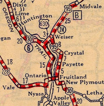
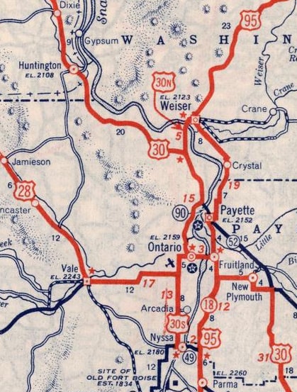
US 630 was the shortest mainline US route ever, weighing in at a whopping 3 miles.  Its history also involves US 30 and US 95, and there is some question whether it was ever signposted, because old maps have conflicting info.  When the US routes were first commissioned in 1926, US 630 was not included on the list.  US 30 followed what is now Business 30 between Fruitland ID and Ontario OR, and then OR hwy. 201 up to Weiser Jct. OR, and across to Farewell Bend.  At that time, there was also a "US 30N" in the area: it departed US 30 at Fruitland and followed today's US 95 north through Payette to Weiser.  Routings through town have changed a bit over the years, but from Weiser it was essentially directed along what is now signed as "Spur US 95" across the river into Oregon, where it reconnected with US 30 at Weiser Jct.  Originally the south beginning of US 95 was at its junction with US 30N in Weiser.
All of that is according to route logs.  However, the earliest maps tell a different story:
Picture
c. 1927, Rand McNally
Picture
c. 1927, Teminal Hotels
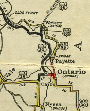
Apparently in 1927, US 630 was commissioned, in a move that may have been an attempt to get rid of the US 30N designation: some maps (such as the ones above) indicate that US 630 replaced US 30N from Weiser ID to Weiser Jct, and that US 95 was extended down to US 30 at Fruitland, replacing US 30N between there and Weiser.  Other information suggests that US 30N was never decommissioned, but that US 630 and US 95 were co-signed with it.

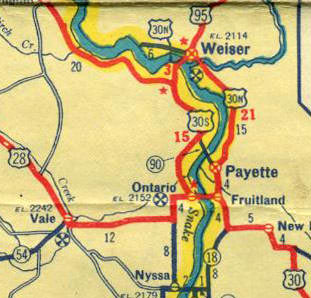
However, if the intent was to get rid of US 30N, it was unsuccessful: it was actually US 630 that ended up getting decommissioned -- just six years later, in 1933 -- while US 30N lasted for another 50 years.  It is unclear whether US 95 was cut back to its original terminus in Weiser, or whether it had ever been signed down to Fruitland at all.  Most maps from that timeframe seem to indicate that US 95 still ended in Weiser.  This first one had an error "US 30S" shield north of Ontario, but beyond that they all showed the same arrangement:
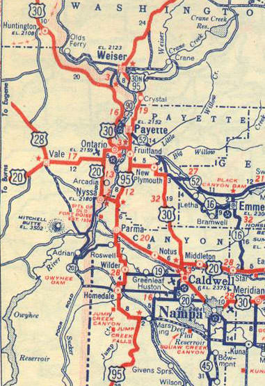
Picture
c. 1937, Texaco
Picture
c. 1937, Smiling Associated
Picture
c. 1939, Rand McNally
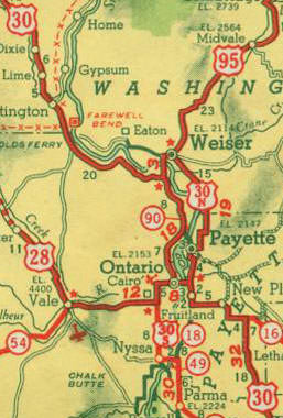
If US 95 had not been signed down to Fruitland beforehand, it certainly was by 1940, because that year the designation was extended far to the south of Idaho.  This 1940 map avoided the issue of the designation of the highway between Weiser and Fruitland...
Picture
c. 1940, Rand McNally
Picture
c. 1944, State Farm
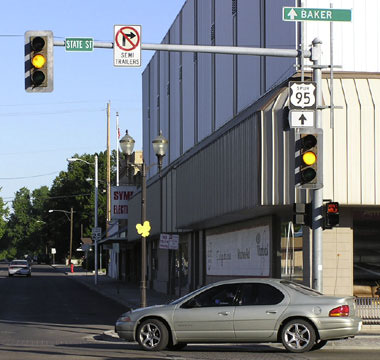
...and that 1944 map is the earliest I've seen that explicitly labels that segment as both US 30N and US 95.  This photo shows the historic junction in Weiser, as seen from what used to be southbound US 95:
Picture
Elbert, July 2005
Originally US 95 followed State Street to this point and ended.  It is possible that westbound US 30N was to the right on Main Street, although some maps indicate that it may have gone ahead two blocks before turning right on Commercial Street.  Either way, eastbound US 30N was to the left (a movement that cannot be made anymore, because Main is one-way through downtown.  Today the next block [Idaho Street] is used for eastbound traffic.)  Starting the next year (1927), the north beginning of US 630 was either straight ahead or to the right on Main.  (Much later, when Spur 95 was introduced, its north beginning was to the right, and the signs shown in these photos are leftovers from that arrangement.)
If US 95 was ever extended down to Fruitland before 1940, it would have turned left here on Main and then followed the Snake River south to US 30:
Picture
Elbert, July 2005
That is in Fruitland, looking south on Whitley Drive at 16th Street.  That was the east end of US 30N... and if US 95 ever replaced US 30N, then its south end would have been here too.  Here we are looking the opposite direction:
Picture
Sanderson, Mar. 2001
That is westbound US 30, which turns left on 16th.  The east beginning of US 30N was straight ahead, and it is possible that was the south beginning of US 95 as well.  Both routes passed through Payette and came to the junction in Weiser described above and shown again here:
Picture
Elbert, July 2005
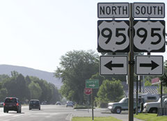
That was looking west on Main at State.  That used to be westbound US 30N (which continued either by turning left or going straight ahead).  Also going one of those two directions was the north beginning of US 630.  Northbound US 95 originally began to the right.  At the time, Spur 95 (the designation that now serves in place of both US 30N and US 630 south and west from here) was well-signed through Weiser. 
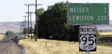
​Ahead about a mile or so is where the highway crosses the Snake River and exits the state of Idaho.  Just before that bridge, there was an "End" sign in 2005...
Picture
Elbert, July 2005
Picture
Elbert, July 2013
...which was strange, because Spur 95 certainly continues ahead into Oregon (and by the time of the 2013 photo, it had been removed).  In fact, almost all signs had been replaced by then:
Picture
Elbert, July 2005
Picture
Elbert, July 2013
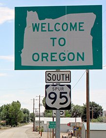
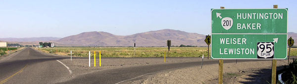
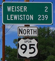
​Those were looking into the little community of Annex, just across the river from the photos above.  About a mile ahead, we reach the true south end of Spur 95...
Picture
Elbert, July 2005
Picture
Elbert, July 2013
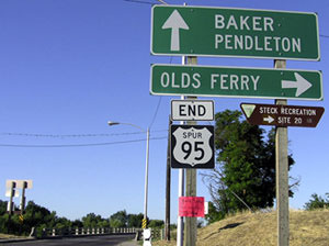
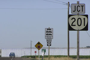
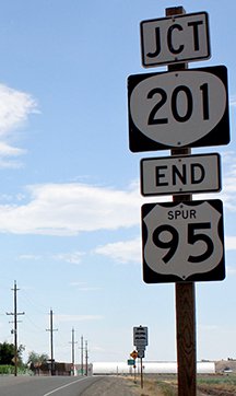
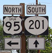
...and it is good to see that an "End" sign has been added.  Back when US 630 existed, it ended here because US 30 was routed along what is now OR hwy. 201.  This was also the west end of US 30N.  Signage in the distance is shown close-up here:
Picture
Elbert, July 2005
Picture
Elbert, July 2013
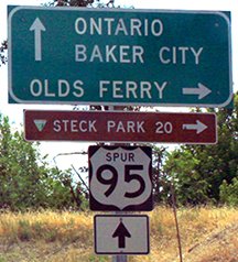
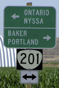
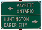
Interesting how the control cities were changed.  From eastbound historic US 30, the former south beginning of US 630 (and west beginning of US 30N) looks like this...
Picture
Elbert, July 2005
Picture
Elbert, July 2013
...and here is the signage from westbound:
Picture
Elbert, July 2005
Picture
Elbert, July 2013
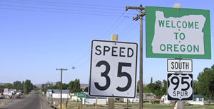
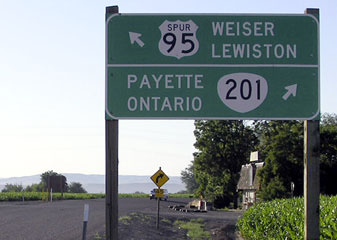
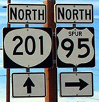
That is the original US 30 heading off into the distance, and US 630 used to begin to the right.  Upon turning that direction, one soon sees this sign:
Picture
Elbert, July 2005
Picture
Elbert, July 2013
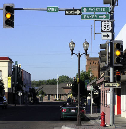
Today in Weiser, Spur 95 goes a few blocks beyond its original north end (and the historic north end of US 630), because in the 1990s US 95 was rerouted such that it bypasses downtown to the east via East 7th Street.  Here is where Spur 95 ends now:
​That was looking east on Main at 7th.  At various times, this was also eastbound US 30N and southbound US 95, both of which continued to the right.
Picture
Elbert, July 2005
That was looking east on Main at 7th.  At various times, this was also eastbound US 30N and southbound US 95, both of which continued to the right.
Back to main US 95 page

Research and/or photo credits: Christ Elbert; Dale Sanderson
Page originally created 2003;
last updated Apr. 30, 2016.
Copyright © 1998-2023
Picture