US Ends .com
  • Home
  • Store
    • US highway map
    • Florida US highway map
  • Endpoints
    • US 1 - US 9 >
      • 1 >
        • 201
        • 301
        • 401 [i]
        • 401 [ii]
        • 401
        • 501
        • 601
        • 701
      • 2w >
        • 102
      • 2e >
        • 202
        • 302
      • 3
      • 4 >
        • 104
      • 5
      • 6 >
        • 106
        • 206
      • 7
      • 8
      • 9 >
        • 109*
        • 209
        • 309
    • US 10 - US 19 >
      • 10 >
        • 110
        • 210
        • 310
        • 410
      • 11 >
        • 111
        • 211
        • 311
        • 411 [i]
        • 411 [ii]
        • 411
        • 511*
        • 611
        • 711*
      • 12 >
        • 112
        • 212
        • 312
      • 13 >
        • 113
        • 213
      • 14
      • 15
      • 16 >
        • 116
        • 216
      • 17 >
        • 17-1
        • 117 [i]
        • 117
        • 217
      • 18 >
        • 118
        • 218
      • 19 >
        • 119
        • 219
        • 319
    • US 20 - US 29 >
      • 20 >
        • 120
        • 220
        • 320
        • 420
      • 21 >
        • 121 [i]
        • 121
        • 221
        • 321
        • 421
        • 521
      • 22 >
        • 122 [i]
        • 122 [ii]
        • 222
        • 322
        • 422e
        • 422w
        • 522
        • 622*
      • 23 >
        • 123 [i]
        • 123
        • 223
      • 24 >
        • 124
        • 224
      • 25
      • 26 >
        • 126
      • 27 >
        • 127
        • 227
      • 28
      • 29 >
        • 129
    • US 30 - US 39 >
      • 30 >
        • 130
        • 230
        • 330
        • 430
        • 530
        • 630*
        • 730
        • 830
      • 31 >
        • 131
        • 231
        • 331 [i]
        • 331
        • 431
      • 32
      • 33
      • 34
      • 35
      • 36 >
        • 136
      • 38 >
        • 138
    • US 40 - US 49 >
      • 40 >
        • 140
        • 240
        • 340
      • 41 >
        • 141
        • 241 [i]
        • 241 [ii]
        • 341
        • 441
        • 541
        • 641
      • 42
      • 43
      • 44
      • 45
      • 46
      • 48 [i]
      • 48 [ii]
      • 48
      • 49
    • US 50 - US 59 >
      • 50 >
        • 150
        • 250
        • 350
        • 450
        • 550
        • 650
      • 51 - 55 >
        • 51 >
          • 151
        • 52 >
          • 152
        • 53
        • 54 >
          • 154
        • 55
      • 56 >
        • 156
      • 57
      • 58 >
        • 158
        • 258
      • 59 >
        • 159
        • 259
    • US 60 - US 69 >
      • 60 >
        • 160
        • 260
        • 360
        • 460
      • 61 - 65 >
        • 61 >
          • 161
        • 62
        • 63 >
          • 163 [i]
        • 64 >
          • 164 [i]
          • 164 [ii]
          • 264
        • 65 >
          • 165
      • 66 >
        • 166
        • 266
        • 366 [i]
        • 366 [ii]
        • 466
        • 566
        • 666
      • 67 >
        • 167
      • 68 >
        • 168
      • 69 >
        • 169
    • US 70 - US 79 >
      • 70 >
        • 170
        • 270 [i]*
        • 270
        • 370
        • 470
      • 71 >
        • 171
        • 271
        • 371 [i]
        • 371
      • 72 - 76 >
        • 72
        • 73
        • 74
        • 75 >
          • 175
          • 275
        • 76 >
          • 176
          • 276
      • 77 >
        • 177
        • 277
        • 377
      • 78 >
        • 178
        • 278
        • 378
      • 79
    • US 80 - US 89 >
      • 80 - 84 >
        • 80 >
          • 180 [i]
          • 180
          • 280
          • 380
        • 81 >
          • 181
          • 281
        • 82
        • 83 >
          • 183
          • 283
          • 383
        • 84
      • 85 - 89 >
        • 85 >
          • 185
          • 285 [i]
          • 285
          • 385 [i]
          • 385
          • 485
        • 87 >
          • 187
          • 287
        • 89 >
          • 189 [i]
          • 189
    • US 90 - US 99 >
      • 90 - 94 >
        • 90 >
          • 190
          • 290
        • 91 >
          • 191
          • 491
        • 92 >
          • 192
        • 93
        • 94
      • 95 -98 >
        • 95 >
          • 195
          • 295
          • 395
        • 96 [i]
        • 96
        • 97 >
          • 197
        • 98
      • 99 >
        • 199
        • 299
        • 399
    • Anomalies >
      • 101
      • 163
      • 400
      • 412
      • 425
  • Places
    • A-L >
      • A >
        • Aberdeen
        • Albuquerque
        • Amarillo
        • Apalachicola
        • Astoria
        • Atlantic
      • B >
        • Baltimore
        • Baton Rouge
        • Bay Area
        • Bishop
        • Boone
        • Brady
        • Bristol
        • Brownsville
        • Brunswick
      • C >
        • Charleston
        • Chattanooga
        • Chicago
        • Cincinnati
        • Cleveland
        • Cody
        • Corpus
        • Cortez
        • Council Bluffs
        • Covington
        • Crescent
        • Cumberland Gap
      • D-E >
        • Dallas
        • Des Moines
        • Detroit
        • Dothan
        • Douglas
        • El Paso
        • Eugene
        • Erie
      • F >
        • Farmington
        • Flagstaff
        • Florence
        • Fox Valley
        • Franklin
      • G >
        • Gallup
        • Grand Junction
        • Grand Portage
        • Grayling
        • Great Falls
        • Greeley
      • H-I >
        • Hardeeville
        • Harrisburg
        • Holbrook
        • Idaho Falls
        • Int'l Falls
      • J-K >
        • Jacksonville
        • Joplin
        • Junction
        • Kansas City
        • Keokuk
        • Key West
        • Kingman
      • L >
        • Laredo
        • Lewiston
        • Long Beach
        • Los Angeles
        • Louisville
        • Lubbock
    • M-R >
      • M >
        • Mackinaw
        • Madison
        • Maryhill
        • Maysville
        • Miami
        • Midway
        • Miles City
        • Milford
        • Milwaukee
        • Minneapolis
        • Mobile 31
        • Mobile 31-43-45
        • Montgomery
        • Monticello
        • Mount Vernon
      • N-O >
        • Nags Head
        • Naples
        • Natchez
        • New Castle
        • New Orleans
        • Niagara
        • Norlina
        • Ocean City
        • Oklahoma City
      • P >
        • Pee Dee
        • Pembina
        • Pensacola
        • Petersburg
        • Philadelphia
        • Piegan
        • Pineville
        • Port Arthur
        • Portsmouth
      • Q-R >
        • Quad Cities
        • Rapid City
        • Raton
        • Reading
        • Richmond
        • Rockingham
        • Rouses Point
    • S-Z >
      • S >
        • San Antonio
        • San Antonio NM
        • San Diego
        • Santa Fe
        • Savannah
        • Sioux
        • Springer
        • Springfield
        • St. Ignace
        • St. John
        • St. Paul
        • St. Pete
      • T-U-V >
        • Tallahassee
        • Tampa
        • Toledo
        • Trinidad
        • Ucolo
        • VA Beach
      • W >
        • Walterboro
        • Waverly
        • West Memphis
        • Wilmington
        • Wilson
        • Wrightsville
      • Y >
        • Yellowstone E
        • Yellowstone N
        • Yellowstone NE
        • Yellowstone S
        • Yellowstone W
  • Highways
    • Map of all endpoints
    • Sources
    • History
    • 1926 almost-routes
    • Intra-state routes
    • Numbering
    • Colors
    • Blog
  • Bonus
    • Colorado >
      • Lowest point
      • Antipodes
      • Toponymy >
        • Roots
      • Colloquialisms
      • Populations
      • Denvers
    • Washington Meridian
    • Watersheds >
      • Headwaters Hill
      • Three Waters Mtn.
      • Parting of the Waters
    • Geo-centers >
      • 48 states
      • 50 states
      • North America
    • State corners >
      • AZ-CO-NM-UT
      • CO-UT-WY
      • CO-NE-WY
      • CO northeast
      • CO-KS-NE
      • CO-KS-OK
      • CO-NM-OK
      • NM-OK-TX
      • NM southeast
      • TX northwest
    • ooss.space
  • Connect
    • Author/history
    • Rationale
    • Contact
    • Contributors
    • Submissions

Current and historic US highway endpoint in Pensacola, FL

1927-present
Get your very own map showing all current and historic US routes!

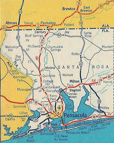
When the US routes were first commissioned in 1926, Pensacola was served by east-west US 90, and by north-south US 331 (which branched off US 31 at Flomaton AL).  In 1935 the US 29 designation was extended south from Tuskegee AL; it met US 331 at Flomaton and the two routes were overlapped down to a common terminus in Pensacola.  This concurrency lasted two years, until US 331 was decommissioned (today's US 331 is a different route).

The earliest detailed map of Pensacola with US highways that I have seen is the inset from Florida's 1936 official.  Its quality is not good enough to reproduce here, but US 29 was shown on Palafox Street, ending at US 90, which ran along Cervantes Street.  Even though downtown Pensacola is several blocks south of there, to my knowledge US 90 traffic was never directed down that way.  So presumably US 29 has always ended at that intersection, and probably US 331[i] did as well.

​Meanwhile, in 1933 the US 98 designation was created; its west end was in Pensacola.  It was shown that way on this map...
Picture
c. 1935, Gousha
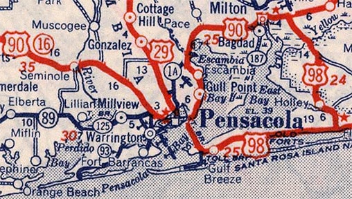
...but originally that may not have been correct, or else it was soon changed.  FDoT maps as early as 1936 indicate that US 98 traffic was not directed across the Pensacola Bay Bridge (as it is today).  The first bridge over the bay was opened in 1931; initially it was tolled, and that probably explains why US 98 could not use it (at least not without a free alternative).  Instead, traffic was directed north from Navarre (via today's FL 87) to the Milton area, where US 98 joined US 90 westward into Pensacola.  US 98 almost certainly ended on Cervantes at Palafox, sharing a terminus with US 331 for a few years, and then with US 29.  Some maps from the 1930s and '40s show a US 98 shield on both routes:
Picture
c. 1940, Rand McNally
Presumably that is because mainline US 98 used the inland route, while the shoreline route was "Toll US 98".  The first FDoT map to show US 98 only along the shoreline route was the 1947 issue.  (The following year, the Pensacola Bay Bridge was christened the Thomas A. Johnson Bridge, after a man who was instrumental in having the tolls removed.)  The Pensacola inset on that edition of the map showed US 98 continuing north on 17th Avenue, joining US 90 at Cervantes.  Formerly there was a cool blue shield posted at that intersection:
Picture
Nitzman, Aug. 1999 (replaced by 2004, gone by 2013)
But did US 98 actually end there?  It seems more likely that it would have been co-signed with US 90 to the west (left), continuing to end at its junction with US 29 at Palafox.  That arrangement is better illustrated on FDoT's 1950 inset:
Picture
c. 1950, FDoT

The first inset to show US 98 turning west off the bridge via Gregory Street (as it does today) was the 1953 issue.  Traffic was then directed north on Alcaniz Street to Cervantes.  But again, did US 98 end at that junction?  Possibly, but it is probable that it continued west a few blocks, ending at Palafox:
Picture
c. 1953, FDoT
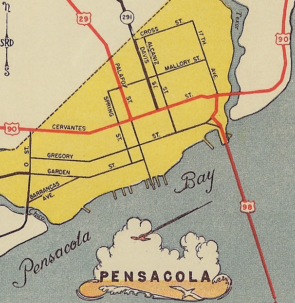
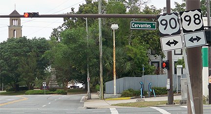
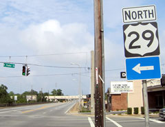
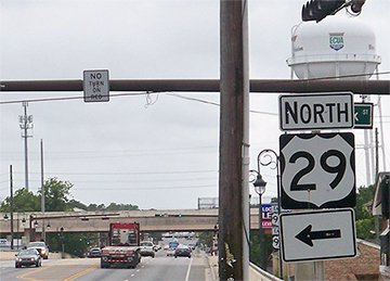
Note that, at the time, the route of today's US 98 was designated FL 298.  The US 98 designation was extended west from Pensacola in 1955, and since then only US 29 has a terminus in the city.  US 90 and US 98 are still twinned along a short segment, and those routes continue to use Cervantes through town.  These photos show the last southbound US 29 marker on Palafox, and (not far beyond that) junction signage approaching its south end:
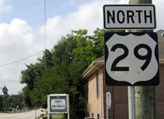
Picture
Karner, May 2013
Picture
Nitzman, May 2004
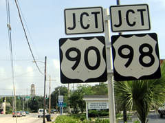
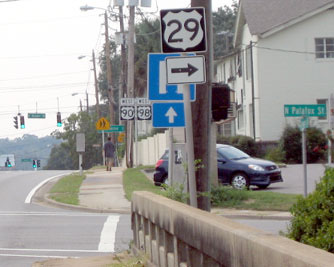
The US 29 designation ends where it intersects Cervantes (US 90-98), which is the cross street in this photo.  Formerly only US 90 (not 98) was noted there, but that was corrected sometime after 2010:
Picture
Nitzman, May 2004
Picture
Karner, May 2013
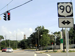
That intersection has marked the south end of US 29 since 1935, and probably US 331[i] before that.  Also, US 98 began to the left on Cervantes, probably from 1933 to 1955.  These photos were looking the opposite direction (north from Cervantes, up Palafox) at the first northbound confirming marker:
Picture
Nitzman, 1999
Picture
Nitzman, May 2004 (unchanged as of 2013)
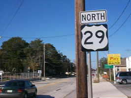
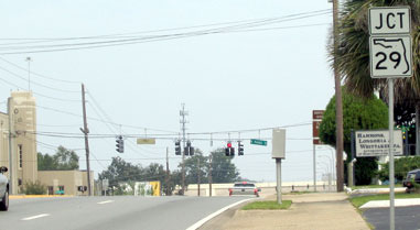
These shots show signage for the south beginning of US 29 from US 90-98.  This first one was looking westbound, but this sign may have been the victim of a hurricane, because unfortunately it was gone by 2006, and still no replacement as of 2015:
Picture
McDonald, Sep. 2003
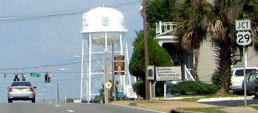
Most likely that was the historic west end of US 98.  Today US 29 begins to the right, and that was probably the south beginning of historic US 331 as well.  FDoT got the sign correct there, but check out the signage that was formerly on eastbound US 90-98:
Picture
McDonald, Sep. 2003
Picture
Nitzman, May 2004
That was approaching Palafox; formerly the state route shield error was repeated at the intersection itself, but by 2004 both of those assemblies had been replaced...
Picture
McDonald, Sep. 2003
Picture
Nitzman, May 2004
Picture
Karner, May 2013 (unchanged as of 2018)
...and by 2006 that "interstate" arrow (white-on-blue) had been replaced with a "state route" arrow (black-on-white).  Straight ahead was probably the west beginning of US 98 for a couple decades.
main US 29 page
main US 98 page
main US 331 page
Research and/or photo credits: Martin Karner; Josh Lintz; Larry McDonald; Alex Nitzman; Dale Sanderson
Page originally created 2003;
last updated Oct. 16, 2020.
Copyright © 1998-2023
Picture