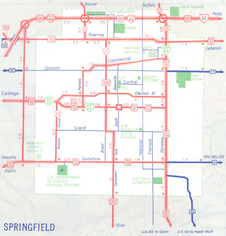
Historic US highway endpoints in Springfield, MO
|
1927-1965
|
 |
|
US 60 was among the original routes commissioned in late 1926, but for the first few years the designation ran only as far west as Springfield:
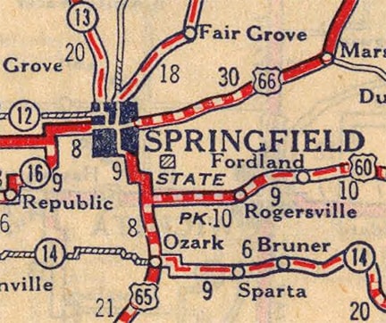
c. 1927, Rand McNally
|
That map suggests that US 60 could have ended at its junction with US 65 south of town, but Missouri official state highway maps from the same timeframe explicitly show that US 60 overlapped with US 65 further north:
c. 1930, MODOT
|
|
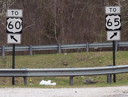
Today US 60 traffic uses the James River Freeway, while US 65 is routed along the Schoolcraft Freeway. But historically those two routes met at what is now the junction of Farm Road 181 and River Road, just to the south and east of the modern interchange. In fact, in the gore where those two highways historically diverged, an assembly referencing each route is still posted:
|
Sanderson, Mar. 2018
|
|
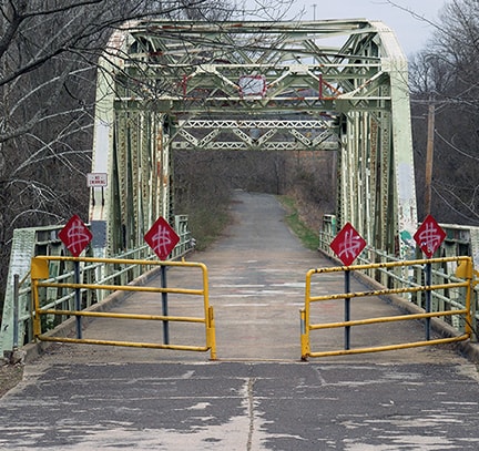
From there US 60-65 traffic was directed northwest on River Road, over the James River via an old bridge which is no longer open to automobile traffic, but which is still in use as a segment of the Galloway Creek trail system:
|
Sanderson, Mar. 2018
|
|
On the opposite (north) side of the bridge, the old road has been wiped out because of the modern interchange, but historically it went on to connect with Lone Pine Avenue. US 60-65 continued up past Sequiota Park, then made a broad curve west onto Seminole Street. This curve has been vacated and is now used for a church parking lot, but it is still surfaced with the old concrete. It is visible to the left in this image, looking north on Lone Pine (in these interactive images, click the + button to zoom in):
|
|
|
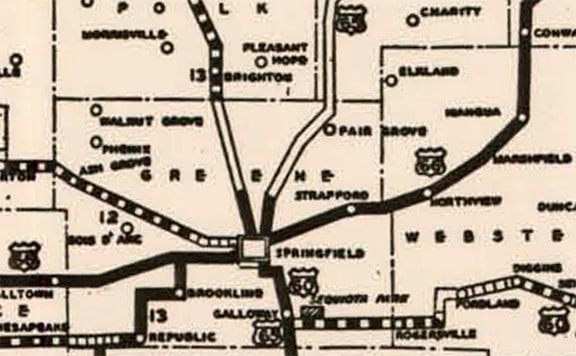
An old USGS topo suggests that the US 60-65 overlap went west on Seminole as far as the National Cemetery, but that Glenstone Avenue heading north from there carried only US 65. And the route log on Missouri's 1928 official state highway map also indicated that US 60 ended at the cemetery:
|
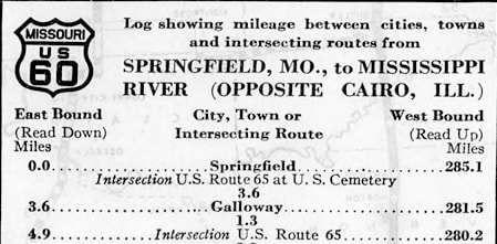
c. 1928, Missouri DoT
|
|
This photo was taken looking south on Glenstone (historic US 65, now Business 65). On the right is the National Cemetery; to the left on Seminole was possibly the north beginning of US 60 for a brief time:
|
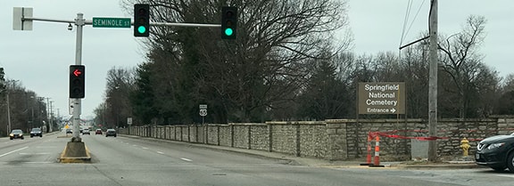
Sanderson, Mar. 2018
|
|
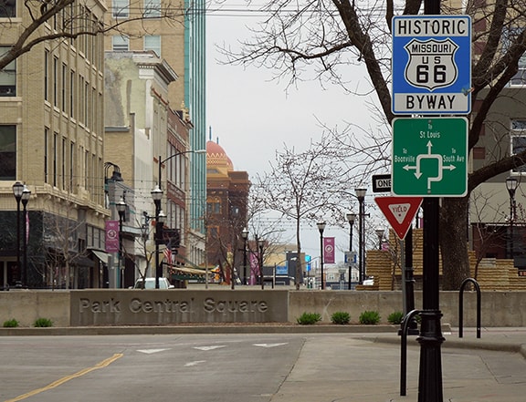
It is a little difficult to believe that US 60 terminated there for long, because during those early years, it was common to co-sign routes to a central location in the downtown area. It is clear that US 60 did not end at its junction with US 65 south of town; it was co-signed northward. It would have been pointless to carry the overlap only as far as the cemetery (which at the time was on the outskirts of town), but not the rest of the way into Springfield. So it is conjectured that US 60 traffic would have been directed to the "route center" of Springfield, which was most likely Park Central Square. This image is looking west on Park Central:
|
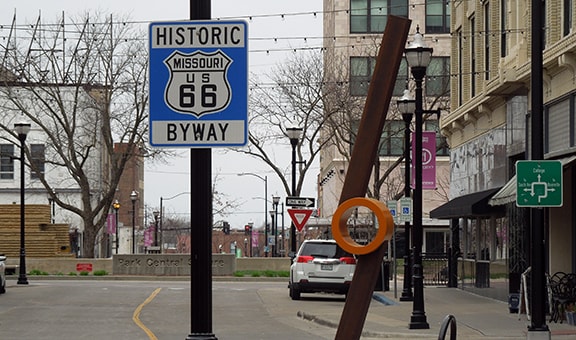
Sanderson, Mar. 2018
|
|
Behind the camera, Park Central becomes St. Louis Street. Just ahead, the original route of US 66 went around the Square, and Park Central heading that direction becomes College Street. It seems logical that in the 1920s and '30s, US 60 would have been co-signed with US 66 to this point. In fact, even a couple decades later, the "City US 60" designation was still routed through Park Central Square:
|
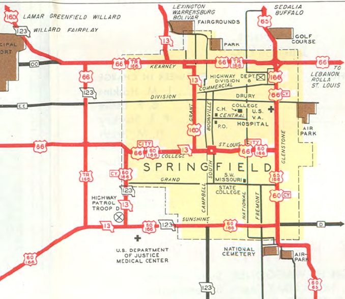
c. 1953, MODOT
|
|
That map is also useful for pinpointing the termini of two other routes that historically ended in Springfield: US 160 and US 166. US 160 was commissioned in 1930, and its east end was in Springfield until 1953. It is likely that traffic was always directed downtown, even though some inset maps after 1936 suggest it ended on Kearney Street at the West Bypass (because US 66 had been redirected around the city using those roads). But the map above shows it continuing east on Kearney, then heading south on Grant Avenue. It could have ended at College, but again, in the 1930s it is more likely that it would have been co-signed with US 66 a few blocks east, ending at Park Central Square. This shows the perspective coming from that direction:
|
Sanderson, Mar. 2018
|
That was the east end of US 160, and straight ahead was the historic west beginning of US 60 (although by the time US 160 was commissioned, US 60 had already been extended west from Springfield). The map above showed that Campbell south of town was SH 123, but the map from the following year (1954) indicated that the US 160 designation had been extended out of town along that route.
|
And finally, in the upper right corner of the map above, the east terminus of US 166 is shown at the junction of Kearney and Glenstone. That was the case for about a 20-year period (1945 to 1965). This photo shows how that intersection looked during that timeframe:
|
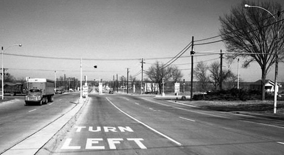
c. 1958 (linked to source)
|
|
That area was quite a bit more rural than it is today; this is a current image looking west on Kearney, or historic westbound US 66:
|
|
|
Historically, the signage posted approaching that intersection from the same direction looked like this:
|
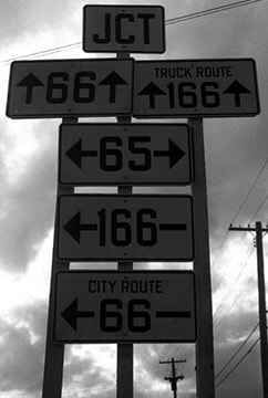
c. 1954 (linked to source)
|
|
To the right on Glenstone was northbound US 65. Southbound was to the left, as was City US 66, and the east beginning of US 166. Mainline US 66 was straight ahead on Kearney, as was the east beginning of Truck US 166 (which joined mainline 166 on the opposite end of town, at the intersection of Sunshine Street and the West Bypass).
This photo was taken approaching the same intersection from the south: |
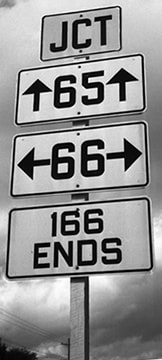
c. 1954 (linked to source)
|
|
When I-44 was completed across the north side of town in about 1961, the US 166 designation was extended about a half-mile north on Glenstone, ending at I-44's interchange 80:
|
c. 1963, MODoT
|
|
Shown here is a view from westbound I-44, taken during the brief timeframe during which US 166 began by heading south on Glenstone with US 65:
|
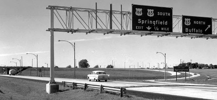
c. 1962 (linked to source)
|
A few years later, in 1965, US 166 was truncated to its current terminus near Joplin, and since then no US routes have endpoints in Springfield.
Research and/or photo credits: Nathan Edgars; Mike Roberson; Dale Sanderson
Page originally created 2014;
last updated Apr. 4, 2018.
last updated Apr. 4, 2018.
