End of US highway 285 |
 |
|
1934-1969
|
1969-1978
|
1978-present
|
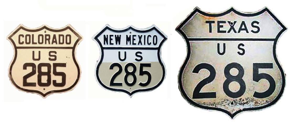
Summa
|
Mileage: in 1989 AASHTO listed a figure of 835 miles for US 285. That is reasonably close to our own 2022 measurement, which yielded 845.8 miles (5.3 miles of that difference is explained by the Roswell bypass). Its midway point is within a mile or two of Clines Corners NM. Historically, when US 285 went to Aurora, it was 854.5 miles long.
|
|
There was a US 285 commissioned along with the first US routes of 1926. It began in Denver (as does the current US 285), but that original route actually went north from the city, essentially along what is now US 287; more info on the US 285 [i] page.
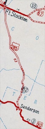
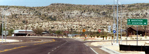
In 1934 changes were made to many western US highways; that was when the designation "US 285" was applied to the current corridor. From Denver, US 285 continues through central Colorado, then New Mexico, ending in west Texas. US 285's south terminus has always been at its junction with US 90 in Sanderson... but at first, along some segments, it would have been a stretch to call it a "highway". On this map, the 120-mile section between Sanderson and Pecos was shown as an "earth road", which was a lower classification than even a "gravel-surfaced road": |
c. 1936, TXDoT
|
c. 1936, TXDoT
|
|
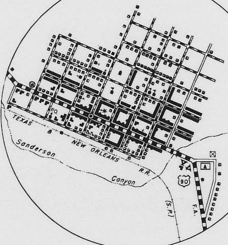
That map suggests that US 90 originally used Legion Street on the east side of town, and Cargile Avenue on the west end. If so, then the original south end of US 285 would have been on Cargile, just to the north and east of its current terminus. But the north end of Cargile was vacated in the 1960s or earlier, and modern aerial photos show no trace of a former highway junction there. At the current junction, southbound US 285 traffic turning westbound onto US 90 is directed onto a slip ramp prior to the stop sign at the mainline:
|
Taylor, Sep. 2000
|
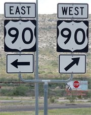
Sanderson, Aug. 2013
|
|
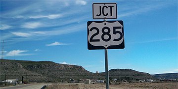
In 1988 there was no "End" sign posted at the junction with US 90, but by 2000 one had been added, and as of 2013 an assembly was still there:
|
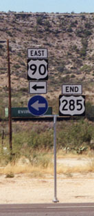
Heading east on US 90, there was only a junction sign for US 285, but nothing beyond that:
Karners, Dec. 2014
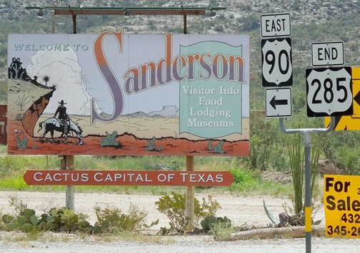
From there, Sanderson's business district is about a half-mile straight ahead on US 90.
|
|
These shots were taken looking the opposite direction (west on US 90):
|
Taylor, Sep. 2000
|
Sanderson, Aug. 2013
|
|
The south beginning of US 285 is to the right; travelers taking that turn will immediately see the first northbound confirming marker:
|
Taylor, Sep. 2000
|
Sanderson, Aug. 2013
|
|
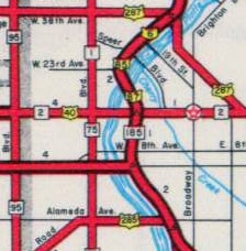
Additional photos can be seen on the Sanderson page. From there, it is 64 miles to the next town, and US 285 passes through a sparsely-populated region of rugged and quiet beauty -- quite a contrast from the highway's other terminus in Denver, 845 miles to the north. Through the mountains southwest of the city, the road was not paved until about 1938; this photo illustrates what it looked like prior to then. Originally US 285 was routed into central Denver via Alameda Avenue, ending at its junction with its "parent" route (US 85), which ran along Broadway:
|
c. 1937, CDoT
|
In 1958, when the "Valley Highway" (today's I-25) was completed through Denver, US 85-87 traffic was removed from Broadway and instead redirected along the new freeway. So the US 285 designation was truncated by about a half-mile, such that it ended at the "new" US 85-87:
c. 1959, CDoT
|
|
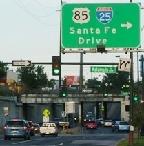
This photo was looking east on Alameda. I-25 runs directly underneath the camera location; access is to the right on Kalamath Street (which is the southbound counterpart to Santa Fe Dr). US 285 ended here for about ten years...
|
Sanderson, Aug. 2006
|
...but until 1958 it continued a bit further ahead. This shot was looking east on Alameda. Broadway is the cross street; it is now one-way southbound, but it ran both ways when it carried US 85 traffic, and when US 285 ended here:
|
Sanderson, Aug. 2006
|
|
These photos are looking the opposite direction (west on Alameda). Here, the cars stopped at the light (Broadway) were about to enter what was once the beginning of southbound US 285:
|
Sanderson, Aug. 2005
|
Barely visible in the distance is the I-25 overpass. When that was built, US 285 was truncated to that location. Today CO hwy. 26 begins there, but during the 1960s that was the north beginning of US 285:
|
Sanderson, Aug. 2006
|
|
This shot was looking north on Broadway at Alameda. Today Broadway is one-way southbound, but when it carried US 85 traffic, it ran both directions. So until about 1958 this was the perspective of a driver on northbound US 85, and to the left on Alameda was the north beginning of US 285:
|
Sanderson, Aug. 2006
|
|
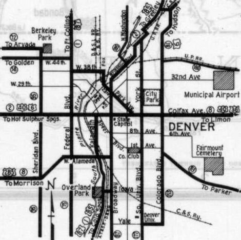
From there, US 285 continued another two miles west, to the five-way intersection of Knox Court and Morrison Road. Then traffic was routed southwest for about 1.5 miles on Morrison, to another five-point intersection: that of Sheridan Boulevard and Mississippi Avenue. From there it was west on Mississippi for a mile to Pierce Street; south for a mile to Jewell Avenue; west for a half-mile to Wadsworth Boulevard; and south for a half-mile to Morrison Road (same name, different segment). Today CO hwy. 8 begins there; it follows Morrison Rd west to the town of Morrison, and then heads south to its junction with modern US 285 near the mouth of Turkey Creek Canyon. Essentially that represents the original route of US 285, except for the part that skirts around the maximum pool area of the more recently-constructed Bear Creek Reservoir.
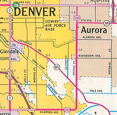
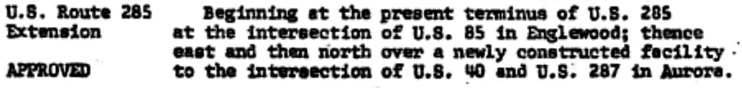
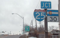
But in 1968, US 285 was re-routed onto Hampden Avenue, through the southern city limits. For the next ten years, the designation continued three miles east of its current terminus at I-25, to where Hampden rounds into Havana Street (bottom center), and then went six more miles north to its intersection with Colfax Avenue: |
c. 1969, CDoT
|
At the time, Colfax carried US 36-40-287, plus Business Loop 70. But for some reason CDoT waited until 1973 to have AASHTO approve that change in the routing of US 285, and by that time US 36 had been moved off Colfax, as was reflected in the agenda item from the minutes of AASHTO's meeting in June of that year:
|
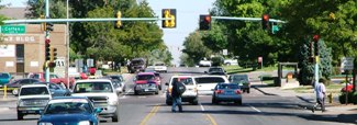
It is also interesting to note that the former terminus of US 285 was said to be at its junction with US 85 in "Englewood", even though the route never entered Englewood city limits prior to the 1969 reroute. Anyway, this photo shows that intersection in Aurora, looking north on Havana at Colfax, where US 285 ended starting in 1969:
Sanderson, Apr. 2006
|
This photo was looking west on Colfax; historically US 285 began to the left (south) on Havana:

Sanderson, June 2001
|
At their June 1978 meeting, AASHTO approved CDoT's request to eliminate the US 285 designation between I-25 and Colfax...
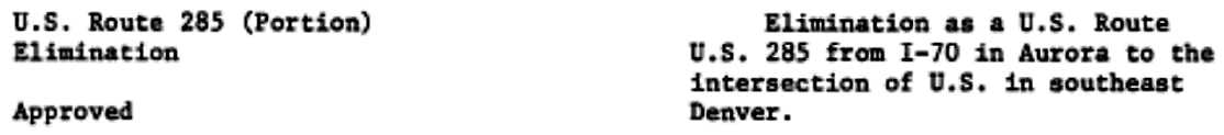
Again, poorly worded: US 285 never went all the way to I-70 (the reference may have been to Business 70). Also, the intersection in southeast Denver should have been described as a junction with I-25 and US 87.
|
Formerly the west end of CO hwy. 30 was on 6th Avenue at Havana, shown on the map above at upper right. But when the 285 designation was truncated to its current terminus, all of the decommissioned segment (except the northernmost mile) became part of an extended CO 30:
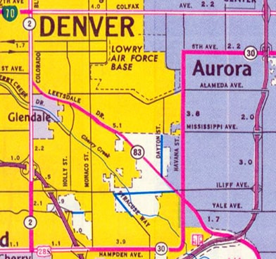
c. 1979, CDoT
|
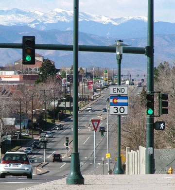
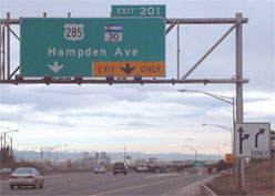
In these photos, we are heading east on Hampden, or "north" on the final segment of US 285. The last northbound 285 shield was just past the five-way intersection with Dahlia Street/Happy Canyon Road:
That was the final reference to US 285 (although it was gone by 2016, and now the last marker is almost four miles west of the terminus). In the distance is visible the ridge atop which I-25 runs through the south metro area. Today that is where the US 285 designation ends, and the CO 30 designation begins:
Sanderson, Feb. 2001
|
|
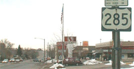
Approaching that interchange, these sign assemblies were on the gore that splits eastbound Hampden traffic from the onramp to southbound I-25:
|

Sanderson, Feb. 2001
|
Sanderson, Nov. 2006
|
|
In the background of that 2001 photo, a large green overhead sign is visible; it directed downtown Denver traffic left towards Fort Collins via northbound I-25. That is shown close-up here:
|
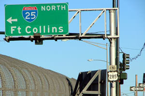
Sanderson, Jan. 2004
|
Sanderson, Oct. 2008
|
|
The Hampden overpass was rebuilt; construction began in 2004, and was complete in 2006. At that time, all signage at the interchange was replaced. Prior to that, Hampden was signed as if it were more of a high-speed highway, but now it is signed more like an average city arterial... and unfortunately the "End" assembly was not replaced:
|
Sanderson, Jan. 2004
|
Sanderson, Jan. 2004
|
|
Note the 3-digit number on a 2-digit shield; that may have dated back to 1979. In January 2004 the whole assembly was removed for construction; in that photo it had been disassembled and was lying on the ground by the northbound offramp. Next, we will head the opposite direction (west on Hampden):
|
Sanderson, Feb. 2001
|
Sanderson, Nov. 2006
|
|
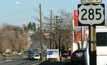
Those were posted just west of Monaco Street. The interchange ahead is where CO 30 ends and US 285 begins... although US 285 is under-signed for traffic heading this direction (west). Ahead there are signs for drivers who want I-25, but there is no indication that US 285 traffic should continue straight ahead:
|
Sanderson, Jan. 2022
|
On a clear day, the vista from the Hampden overpass is spectacular. In that part of town, I-25 runs along a ridge separating two of Denver's major watersheds, and then Hampden sits on top of that freeway. So there is a nice view of downtown to the north, as well as just about the entire Front Range to the west (but unfortunately there is usually too much traffic to do any rubbernecking).
|
|
This photo was taken from just a bit further ahead, in the median just east of the terminus:
|
Sanderson, Jan. 2004
|
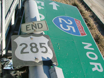
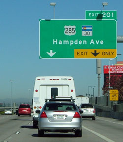
In the photo above, the Mt. Evans massif is visible on the left. In the middleground, the first mile or so of US 285 is visible (the traffic light way off in the distance is the aforementioned Dahlia/Happy Canyon intersection). At the time, auxiliary traffic lights had been installed for the construction that was about to begin at that interchange. Below is a closer shot of the green sign, and the "End" signage mounted on its support:
Sanderson, Jan. 2004
|
Sanderson, Nov. 2006
|
Sanderson, Jan. 2022
|
|
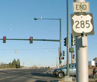
In the middleground of those first two photos, an "End CO 30" assembly was visible; those are shown close-up in these shots (although the "End" sign has been gone since 2017):
|
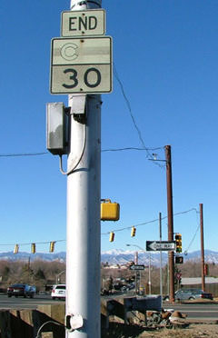
Sanderson, Jan. 2004
|
Sanderson, Nov. 2006 (removed in 2017)
|
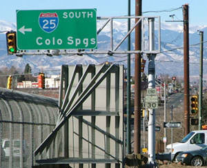
The CO 30 designation ends at the I-25 interchange, and that is where US 285 begins. In that first photo, the colored pigment in the paint was just about gone -- possibly that sign had been there since 1979. Or maybe it was moved from its original location on 6th at Havana, which is where CO 30 ended when it was commissioned in 1955. At the time Havana was CO 70, but US 285 replaced that in 1969... and then when US 285 was cut back to I-25 in 1979, CO 30 was extended south and west along former US 285/CO 70, ending at that interchange.
|
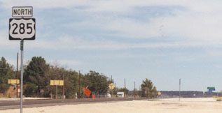
During the 1990s, the first southbound US 285 sign was posted just west of that "End" assembly. But as of early 2001, only a tall, empty post stood there. So at the time, the first 285 sign heading "south" (west on Hampden) was about 3/4 mile further west from there. This photo was looking west on Hampden, just past the intersection with Dahlia and Happy Canyon:
|
Sanderson, Feb. 2001
|
|
When new signage was initially installed in 2006, there was no US 285 confirming assembly. But within a few months after that, one had been added. It is good that there is a 285 marker there now, but it was a little misleading when viewed in the context of the "600 FT" sign (it could be misconstrued to mean that one must make a turn in 600 feet in order to continue following US 285). Actually that sign existed prior to the construction, and it referred to the fact that the right lane ends in 600 feet:
|
Sanderson, Jan. 2007
|
|
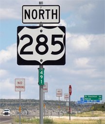
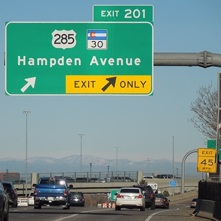
That minor issue was corrected in about 2016; here is a more recent photo of the first southbound sign, along with a view of the "northernmost" half-mile of US 285, plus Mt. Evans in the background:
|
Sanderson, Jan. 2022
|
|
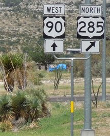
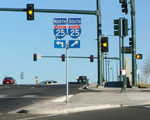
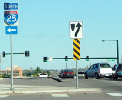
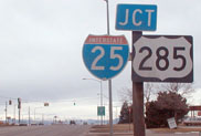
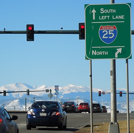
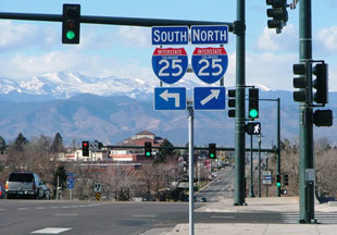
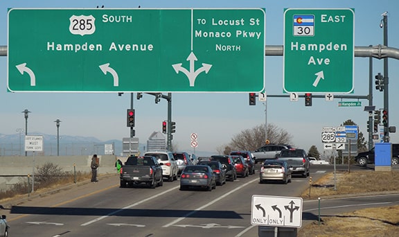
Next are some shots from northbound I-25. Note that no cardinal directions were given for the highways on these signs. Likely that was intentional, to prevent confusion: US 285 is technically "South", but it starts out by heading west on Hampden...
Sanderson, Feb. 2001
|
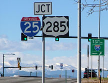
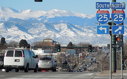
...and CO 30 is kind of a directionless route which very few people would have a reason to follow from end to end:
Sanderson, Oct. 2008
|
Sanderson, Jan. 2022
|
|
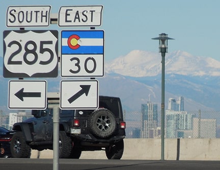
In 2014-15, CDoT added a very large sign bridge to the northbound offramp; the north beginning of US 285 is (quite obviously) to the left:
|
Sanderson, Jan. 2022
|
At far right, in the gore, a ground-level assembly is also posted. That has been around for a much longer period of time, as you can see in this next series of photos. Note how CO 30 formerly had a "North" tab here. Maybe that was because the route obviously heads the opposite direction of US 285. But the other terminus of CO 30 is on Gun Club Road at Quincy Avenue, which is mainly east but also slightly south of this point. So "East" is the more appropriate way to sign that route, and that is what was done on the new assembly:
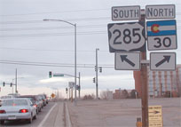
Sanderson, Feb. 2001
|
Sanderson, Oct. 2008
|
Sanderson, Jan. 2022
|
Formerly US 285 itself was not signed with directionals until ten miles west of that interchange. However, directional signage is used on some of the intersecting highways, and more of it has now appeared along Hampden itself. Knowing how best to sign Hampden has probably always been a challenge for CDoT. It can be confusing for people who come to an interchange with Hampden, knowing it is an east/west road, but seeing that their options are to go either "North" or "South" on 285. Personally, I think signage for US 285 should transition to "East/West" at Kenosha Pass: signs along 285 south of there would not change, but east of Kenosha it would be considered an east/west route and signed accordingly. Since US 285 terminates in Colorado, this is a viable option for CDoT, because it would not affect any other state, and there are precedents for this type of situation in other states (more about that on this blog post).
For those interested in more than just the endpoints of US 285, photos taken along the entire 846-mile route are available, and this image shows the eco-regions through which US 285 passes.
For those interested in more than just the endpoints of US 285, photos taken along the entire 846-mile route are available, and this image shows the eco-regions through which US 285 passes.
Research and/or photo credits: Karin and Martin Karner; Dale Sanderson; Michael Summa; Stephen Taylor
Page originally created 1997;
last updated Jan. 16, 2022.
last updated Jan. 16, 2022.
