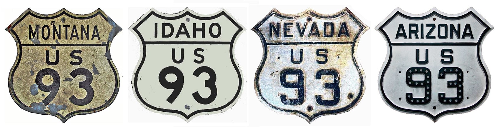
End of US highway 93 |
 |
|
1926-1931
|
1931-1935
|
1935-1965
|
1965-1992
|
1992-present
|
Summa
|
|
Mileage: in 1989 AASHTO listed a figure of 1457 miles for US 93... however, that included the mileage of US 93's associated alternate route. According to the state subtotals on AASHTO's 1989 spreadsheet, mainline US 93's actual end-to-end total at the time was 1340 miles. That is reasonably close to our own 2020 measurement, which yielded 1353.4 miles (reroutings and realignments likely explain the difference).
|
The north end of US 93 has always been at the Canadian border north of Eureka MT, but maps from the earliest years show that the crossing was at the town of "Gateway":
|
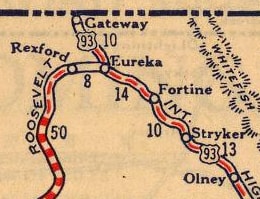
c. 1927, Rand McNally
|
|
It is not possible to get photos from there anymore, because the townsite is submerged beneath Lake Koocanusa, which began to fill in 1975 upon the completion of Libby Dam. But US 93 had already been routed away from Gateway decades earlier; maps as early as 1934 show US 93 serving the current port of entry, called Roosville, which is about five miles east of where Gateway stood:
|
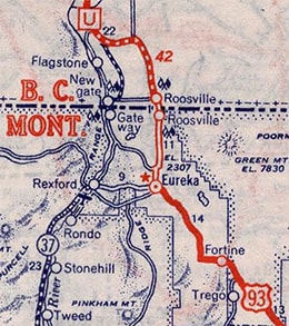
c. 1939, Rand McNally
|
|
There the original road through the original ports (Gateway and Newgate) is still shown, but US 93 had already been moved up out of the valley. This photo was looking north on US 93 at the border:
|
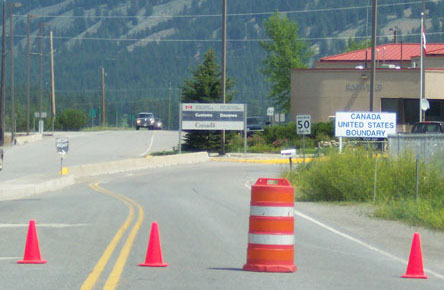
Hamilton, July 2004
|
|
Ahead is British Columbia provincial hwy. 93. Below we are looking south into the US, at the north beginning of US 93...
|
Hamilton, July 2004
|
...and Eureka is about 9 miles ahead.
|
|
Originally US 93 ran from the Canada line only to US 50 in Wells NV:
|
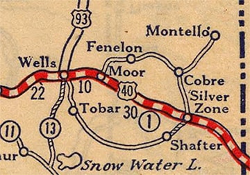
c. 1927, Rand McNally
|
|
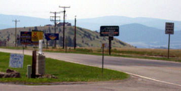
This photo shows the historic terminus, or at least the modern equivalent: this is looking south on US 93. I-80's interchange 352 is visible in the middleground, and part of the East Humboldt Range is visible in the distance. The pickup is travelling west on 6th Street, or historic US 40:
|
Elbert, July 2005
|
|
That segment of US 93 bypasses town to the east. A 1937 map shows that it already existed by then... but did it exist in 1927, when US 93 ended in Wells? It is unclear, but it does seem likely that north-south traffic originally would have been routed through town. If so, US 93 traffic may have crossed the railroad via Lake Avenue, ending at 6th. That intersection is about a half-mile to the west (right) of the intersection shown above. This photo is looking south on Lake at 6th:
|
Elbert, Mar. 2006
|
|
That is possibly where original US 93 intersected US 40 and ended. At any rate, it was only six years later that US 93 was extended south to US 91 in Glendale:
|
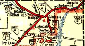
c. 1937, NV DoT
|
|
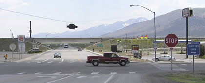
US 93 no longer directly serves Glendale; it has been rerouted to join I-15 southwest of there (roughly where "Dry Lake" is shown at lower left on the map above). Its old route is now designated NV hwy. 168. This photo shows the south end of 168 at I-15's interchange 90:
|

Sanderson, July 2004
|
The road running across the foreground probably carried historic US 91 traffic, so this spot would have marked the south end of US 93. Then, in 1935 (coinciding with the completion of Hoover Dam and the road on its crest), another southern extension brought US 93 to Kingman AZ.
That terminus lasted for around 30 years, but then US 93 was once again extended southward, this time to US 89 at Congress Jct. AZ, just outside Wickenburg. These photos were looking southeast on US 93 at its former south end:
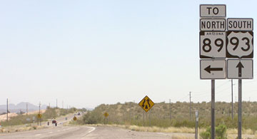
Elbert, Apr. 2008
|
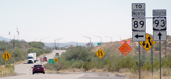
Sanderson, Oct. 2023
|
|
Until 1992, southbound US 89 came in from the left, and then continued straight ahead. This next shot shows the former south beginning of US 93, as seen from the junction with today's AZ hwy. 89:
|
Sanderson, Oct. 2023
|
|
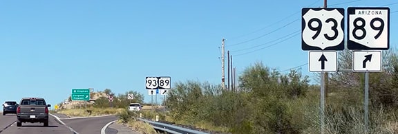
Northbound US 89 took a right there, and northbound US 93 began straight ahead. This photo was taken from what was once southbound US 89...
|

Elbert, Apr. 2008
|
...which continued to the left (or actually straight, then curving left). To the right was the south beginning of US 93. Then in 1992, when US 89 was decommissioned in Arizona, US 93 was extended along its former route to meet US 60 in Wickenburg. So there was a period during which US 93 seemed to be growing southward on an average of every 16 years or so. In the late 1990s I jokingly suggested that we might see it in Gila Bend or Lukeville by 2008. But now it seems like more of a possibility that US 93 could be extended to Phoenix, replacing the current US 60 designation. This would create better route continuity between Phoenix and Las Vegas, which is a segment of the developing Canamex Corridor. As a matter of fact, in 1979 AZDoT did petition AASHTO to have the US 93 designation extended south to Phoenix, but that proposal was not approved (more details on this page).
|
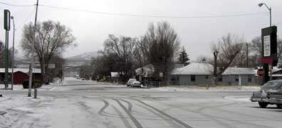
US 93's original Wickenburg terminus is shown in these photos:
|
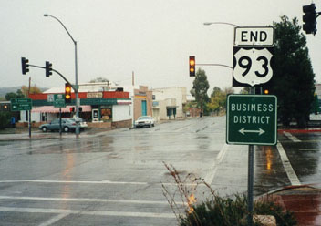
Sanderson, Dec. 1998
|
Elbert, Apr. 2008
|
|
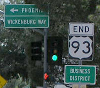
US 93 was formerly routed along Tegner Street. The designation ended at its junction with US 60, or Wickenburg Way, which is the cross street shown in the photos above. These next photos show some of the signs that were posted for the benefit of traffic heading east on US 60:
|
Elbert, Apr. 2008
|
Elbert, Apr. 2008
|
|
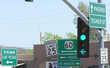
Next we are looking the opposite direction (west on US 60, or Wickenburg Wy):
|
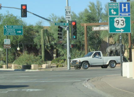
Field, Oct. 2003
|
|
At the time, US 93 began to the right on Tegner. But here is what signage on that traffic signal looks like now:
|
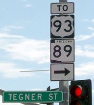
Schecter, Aug. 2010
|
As of 2010, US 93 traffic has been routed off Tegner and onto a new roadway skirting the Hassayampa River. The junction marking the current south terminus of US 93 is now about five blocks behind the camera, and the new highway rejoins US 93's old alignment a ways to the right.
|
|
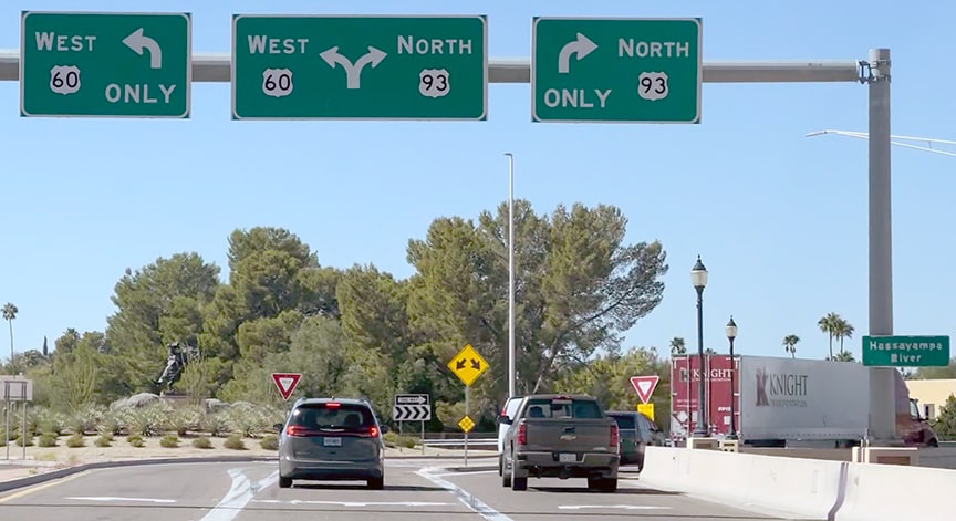
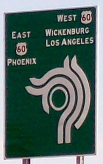
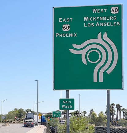
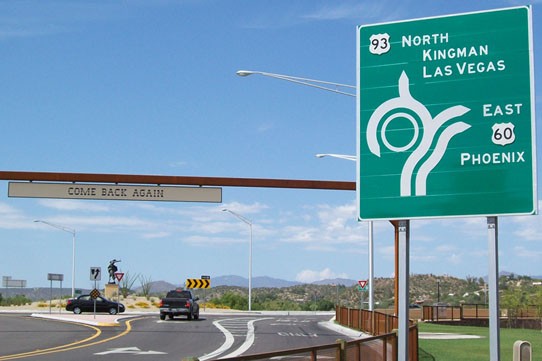
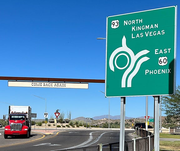
A new traffic circle was constructed where this highway junctions US 60, and that rotary now marks the south terminus of US 93. Here are some views of the new signage posted on westbound US 60:
|
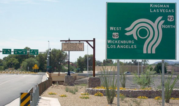
Schecter, Aug. 2010
|
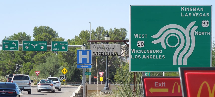
Sanderson, Oct. 2023
|
The diagram is a good idea, but personally, there seems to be something about the execution that makes it a little difficult to decipher... maybe the white lines are a little too thick, or maybe the circle itself should be solid white, or else removed completely. The sign bridge in the distance is shown close-up here:
|
Schecter, Aug. 2010
|
Sanderson, Oct. 2023
|
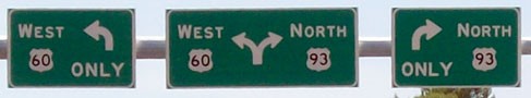
The south beginning of US 93 is to the right. That is indicated one more time in the traffic circle, and if a driver heads that direction, they will soon see the first northbound confirming assembly:
|
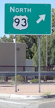
Sanderson, Oct. 2023
|
Schecter, Aug. 2010
|
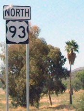
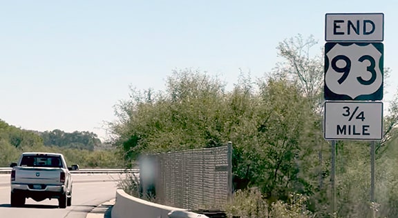
About six miles in that direction is US 93's former Congress Jct. terminus (mentioned previously). Heading the opposite direction (south from Congress Jct.), the last reassurance marker is at the north junction with Tegner (which also has a traffic circle), and then not far beyond that is an "End" assembly that is posted well before the actual terminus:
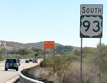
Sanderson, Oct. 2023
|
Sanderson, Oct. 2023
|
|
Continuing south on US 93, the upcoming roundabout is diagrammed thus:
|
Schecter, Aug. 2010
|
Sanderson, Oct. 2023
|
|
There is room for improvement there, too, but the next sign (at the rotary itself) is even worse:
|

Schecter, Aug. 2010
|
Sanderson, Oct. 2023
|
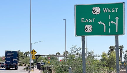
The dashed line there does more harm than good. And finally, here are a couple views of the diagrammatic sign for traffic on eastbound US 60:
Schecter, Aug. 2010
|
Sanderson, Oct. 2023
|
Research and/or photo credits: Nathan Edgars; Chris Elbert; Andy Field; Alan Hamilton; Dale Sanderson; James Schecter; Michael Summa
Page originally created 1999;
last updated Oct. 24, 2023.
last updated Oct. 24, 2023.
