Colorado's land antipodes
What is on the opposite side of the world from Colorado?
|
First, let's quickly define the word antipode*. Picture a globe that rotates on an axis. Imagine this axis is a long rod that enters the globe at the North Pole. Now: where does the rod emerge on the other side of the globe? The South Pole, correct? That's an illustration of an antipode: it's the point on the exact opposite side of the globe. So we can say that the antipode of the North Pole is the South Pole. Likewise, the South Pole's antipode is the North Pole.
|
*My understanding is that the singular "antipode" is pronounced AN-ti-pode, but the plural "antipodes" is pronounced "an-TIP-uh-deez".
|
Of course, one can determine the antipode of any location on the globe (not just the poles). And the concept of antipodes can be applied not only to globes, but also to an actual planet. Wherever you happen to be right now, imagine if you could dig a hole straight down, all the way through the center of the Earth, and come back out the opposite side. Where would you emerge? It seems to me that those of us in the United States commonly believe the answer is "China". (I don't know why - maybe it has something to do with certain books we read as children.) But the truth is, if you live in the US, you wouldn't come out anywhere near China. Drilling down from just about any location in the continental US, you'd actually come out in the South Indian Ocean, somewhere between Africa and Australia.
But there are three exceptions... that is, three tiny areas in the continental US whose antipodes are not in the ocean, but rather on dry land. From a small area of north-central Montana, you would emerge on Kerguelen Island. However, the majority of Kerguelen corresponds to an area across the Canadian border (mostly southeast Alberta, and partially southwest Saskatchewan). There are only two land masses whose antipodes fall entirely within the continental US: Amsterdam Island and St. Paul Island. In fact, the antipodes for both of these islands fall entirely within southeastern Colorado.
But there are three exceptions... that is, three tiny areas in the continental US whose antipodes are not in the ocean, but rather on dry land. From a small area of north-central Montana, you would emerge on Kerguelen Island. However, the majority of Kerguelen corresponds to an area across the Canadian border (mostly southeast Alberta, and partially southwest Saskatchewan). There are only two land masses whose antipodes fall entirely within the continental US: Amsterdam Island and St. Paul Island. In fact, the antipodes for both of these islands fall entirely within southeastern Colorado.
|
Amsterdam and St. Paul are two volcanic islands in the Indian Ocean. They are relatively close to each other (about 50 miles), but they are among the most remote lands on Earth. The next-closest land is the aforementioned Kerguelen Island, an equally remote place about 800 miles to the southwest. Reunion and Mauritius are over twice that far; Madagascar is about 2000 miles away; and continental Africa is over 2500 miles distant. In the opposite direction, Perth (Australia) is about 2200 miles to the east. Amsterdam and St. Paul are administered by France, officially belonging to the Territory of the French Southern and Antarctic Lands. There is no permanent human population on either of these islands (although there is a base on Amsterdam that serves as short-term living quarters for a variety of scientists and researchers). Here is an aerial photo:
|
|
|
If you look slightly east of the northern tip of the island, you can just make out the research base (labeled "La Roche Godon"). Amsterdam Island is oval in shape: about six miles long (from north to south), and about four miles wide, giving it a circumference of about 17 miles, and an area of about 21 square miles. This is not a large area -- for comparison, it is roughly equal in size to what I would call "central Denver" (that is, I-70 on the north to Mississippi Avenue on the south; and Federal Blvd. on the west to Colorado Blvd. on the east):
|
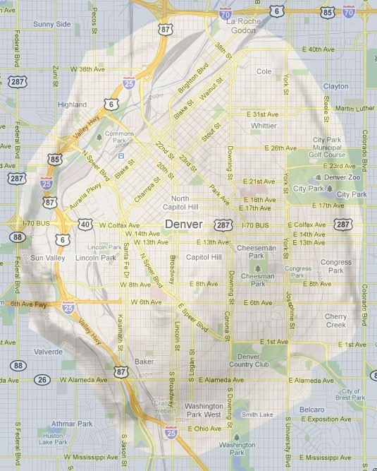
|
|
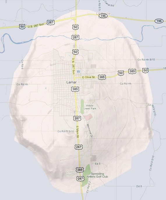
In elevation, Amsterdam rises from sea level to about 2800 feet at its highest point (Mont de la Dives, which may translate to "Mount of the Gods"). The antipodal coastline of Amsterdam falls within Prowers County, Colorado, about 20 miles southeast of Lamar, indicated by the red oval on this map. (As an interesting side note: it just so happens the Granada Branch of the Santa Fe Trail passed right through the antipodal area of Amsterdam.)
|
|
|
Since Lamar is antipodal to Amsterdam, I thought it might be interesting to compare them in size:
|
|
|
St. Paul Island, much smaller than Amsterdam, rises from sea level to about 900 feet. The island could be described as roughly the shape of a right triangle, with the south and west sides each about two miles in length, and the hypotenuse (the northeast side) about three miles long. However, in the middle of the "hypotenuse", the sea has eroded through the wall of the central crater, allowing the crater to form something of a natural harbor (although apparently the channel is too shallow to admit any but the smallest watercraft):
|
|
|
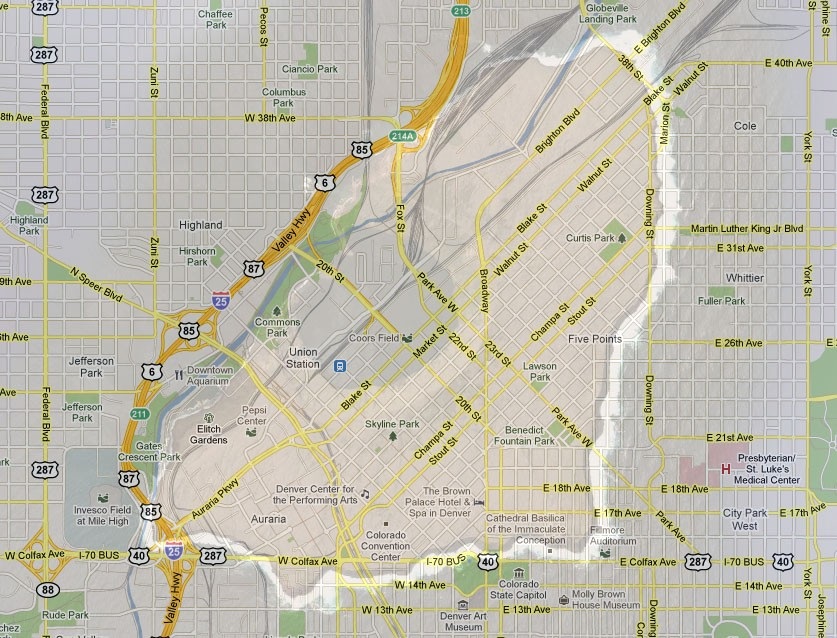
By default, that photo is at the same scale as the one of Amsterdam, above (but of course that's no longer the case if you've zoomed in or out). St. Paul has a total area of only about 2.3 square miles. For comparison, the size and shape of St. Paul almost exactly corresponds to downtown Denver (that is, the triangular area bounded by Colfax Avenue on the south, Downing Street on the east, and the Platte River on the north and west):
|
|
|
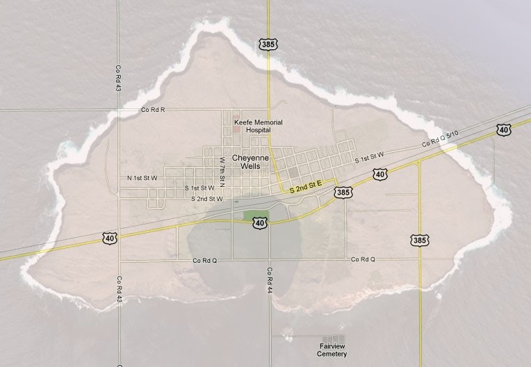
The antipodal coastline of St. Paul is in Cheyenne County, about ten miles southwest of Cheyenne Wells, represented here by the blue polygon:
|
|
|
Speaking of Cheyenne Wells, let's see how that compares in size to St. Paul:
|
|
Except for those dual-image illustrations, all other maps and aerial photos on this page are "live", embedded Google maps, so you can click-and-drag to pan; double-click to zoom in; change the view mode in the upper right; etc. If you zoom in, those maps can give a pretty good idea of the two-dimensional "footprint" of the islands, superimposed on their antipodal locations... but they don't take into consideration the third dimension: elevation. Initially I was thinking: if you were to plop Amsterdam Island on top of its antipodal footprint in southeastern Colorado, it would be pretty impressive to see a mountain rising 2800 feet above the plains outside Lamar. But then, when I considered that this part of southeast Colorado is not at sea level, but rather about 4100 feet above, I realized that a geographically-accurate representation of the antipodal Amsterdam would actually be buried deep beneath the prairie. Standing at an observation point on the ground in Prowers County would be the same as flying 1300 feet above the summit of Mont de la Dives!
It is interesting to consider that Amsterdam and St. Paul are surrounded by water, 800 miles away from the nearest land... while their antipodal area in southeastern Colorado could hardly be more of a contrast: deep in the arid interior of the North American continent, almost 800 miles away from the nearest ocean.
It is interesting to consider that Amsterdam and St. Paul are surrounded by water, 800 miles away from the nearest land... while their antipodal area in southeastern Colorado could hardly be more of a contrast: deep in the arid interior of the North American continent, almost 800 miles away from the nearest ocean.
Research and/or photo credits: Dale Sanderson
Page originally created 2010;
last updated Nov. 17, 2016.
last updated Nov. 17, 2016.
